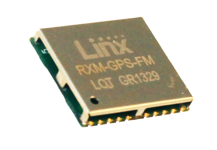
Linx Technologies announces its launch of the self-contained, high-performance FM GPS receiver modules. At 15 x 13 millimeters in size, the MediaTek MT3339-based FM Series gives the module fast lock times and high position accuracy even at low signal levels, the company said.
The module’s very low power consumption helps maximize run times in battery powered applications, such as positioning and navigation, location tracking, marine, and asset management, according to Linx Technologies.
Using the built-in MediaTek MT3339 chipset, The FM module can simultaneously acquire on 66 channels and track on up to 22 channels, providing standard NMEA data messages through a UART interface. A simple serial command set can be used to configure optional features.
The GPS receiver is completely self-contained and only requires an antenna. It powers up and outputs position data without any software set-up or configuration. As a result, the FM Series is easy to integrate, the company said.
With built-in hybrid ephemeris prediction technology, the FM Series predicts satellite positions for up to three days and delivers start times of less than 15 seconds under most conditions.
In addition, the available GPS Master Development System connects a FM Series Evaluation Module to a prototyping board with a color display that shows coordinates, speedometer and compass for mobile evaluation. A USB interface allows simple viewing of satellite data and Internet mapping, as well as custom software application development.
The new Hemisphere GNSS logo uses only the word Hemisphere.
Today, Hemisphere GNSS introduced its new “Hemisphere” corporate branding and logo to reflect its global GNSS focus. The company is also announcing a new website that has been built from the ground up based on customer and partner input.
In February 2013, Hemisphere GPS was renamed and incorporated as Hemisphere GNSS Inc. The company owns both names, but in order to reflect the company’s support of all Global Navigation Satellite Systems (GNSS) and update the company image, Hemisphere GNSS Inc. will be adopting the use of the new “Hemisphere” logo.
“We are pleased to have completed our transition from a GPS agriculture-focused organization to a truly global GNSS Technology and Applications company. Today we are reaffirming our commitment to offering the best value in GNSS OEM boards, antennas, marine positioning, survey, mapping, and machine control products,” said Phil Gabriel, president at Hemisphere GNSS. “We are now introducing our new stylized globe logo and our updated branding to simply read ‘Hemisphere,’ as well as our new website and URL; www.HemisphereGNSS.com.”
The new website is easier to navigate and will assist customers in finding the information they need in a shorter amount of time, the company said. Employee email addresses are also being updated to first name initial, last name @HemisphereGNSS.com, though old email addresses will continue to work for the foreseeable future.
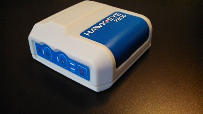
Blue Sky Network’s HawkEye 7200 Portable M2M Tracking Solution.
Blue Sky Network, a supplier of satellite tracking and communication solutions for aviation, land and marine, has launched the HawkEye 7200 portable M2M tracking solution. The HawkEye 7200 includes features such as multinational GNSS receiver support and integrated Bluetooth for Iridium connectivity to smart devices. Designed in a small form factor, the HawkEye 7200 can be powered by battery or via an external power source and is a key addition to Blue Sky Network’s solutions portfolio extending the reach of smart device communications globally anywhere in the world.
The HawkEye 7200 is Blue Sky Network’s first product to incorporate a multinational GNSS receiver. It combines the major GNSS providers into a single location-based chip that can be used in other parts of the world including GLONASS for Russia and the Galileo for the European Union. This multinational GNSS receiver feature enables fleet operators with globally dispersed assets to obtain position reports with increased accuracy and performance. When used with New SkyRouter, Blue Sky Network’s cloud-based web-portal, the HawkEye 7200 offers portable tracking and resource management of any asset type across the globe. The HawkEye 7200 hosts an RS232 interface and digital inputs/outputs for connectivity and control of external sensors or other telematics devices.
With the integrated Bluetooth connectivity, the HawkEye 7200 supports Blue Sky Network’s new iPhone/iPad application. The application allows users to send emails, short-code messages and customizable electronic forms through the Iridium network. With the ability for operators to build and fully customize forms — such as flight plans, maintenance records and logistic records of remote assets — HawkEye 7200 supports the industry’s movement toward paperless fleet operations.
“Blue Sky Network is a long-time member of the Iridium partner ecosystem and is continuously delivering cutting-edge M2M communication solutions targeting new markets,” said Bryan Hartin, executive vice president, commercial sales and marketing of Iridium. “The HawkEye 7200 is yet another solution from Blue Sky Network that offers powerful capabilities and applications that utilize the Iridium network. Together we are providing customers with critical connectivity worldwide.”
“The HawkEye 7200 further bolsters our leadership position in the mobile resource management and tracking industry,” said Blue Sky Network’s CEO and founder, Jon Gilbert. “Combining our HawkEye 7200 with our iPhone/iPad application and our industry-leading backend web portal, New SkyRouter, our customers have a complete end-to-end solution to link the far reaches of the world right in the palm of their hand. We are shrinking the global communication barrier and improving the methods by which people anywhere make connections to manage critical assets and communicate.”
Blue Sky Network is showcasing the HawkEye 7200 at the Helitech International Helicopter Expo & Conference, in London on September 24-26, in booth #B59.
The new HawkEye 7200 is in process of being certified by Iridium, with production expected in Q4 2013.
Kongsberg Seatex has given users of the eBird System the ability to equip SmartWing instrumentation with two additional features — a compass and a GNSS receiver. eBird is a bird concept for lateral, vertical and roll streamer control in marine seismic acquisition that enables fault tolerant and efficient multi-streamer steering by employing a wide range of innovative and patented technological solutions.
The innovative approach of placing a GNSS receiver in the wings opens new opportunities for improving the efficiency of an operation – in particular during launch and recovery but also when running lines.
The built-in GNSS receiver has been implemented based on Kongsberg Seatex’ extensive competence within GNSS technology. Transmission of satellite data from the seismic vessel to eBird reduces the time to first position fix considerably – giving eBird a position with one wing semi-surfaced. The built-in compass has been developed based on Kongsberg Seatex’ deep knowledge and experience within sensor technology and is fully integrated with SmartWing. The compass provides heading information from a submerged eBird.
These add-ons represent further improvements to the eBird streamer positioning and control concept.
“We always try to find improvements to our solutions and these new features are excellent examples of how we combine our core technology and expertise to create improved value for our customers,” says Gard Ueland, President of Kongsberg Seatex AS. “This is one step further in our offering to the seismic market, and we will continue to improve our solutions in close cooperation with our customers.”
eBird has, since its introduction at SEG in 2009, gained high attention within the seismic acquisition community with its sleek and functional design and utilisation of innovative technology together with proven performance in large seismic streamer spreads.
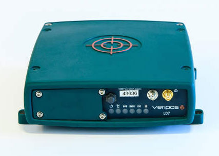
Veripos, supplier of high-precision GNSS positioning services to the offshore industry, has extended its range of integrated mobile receiver units with introduction of a multi-frequency system featuring GNSS heading, L-band positioning and wireless communication capabilities, the LD7.
Typical use is for the provision of high accuracy heading output combined with high accuracy positioning data for vessel systems.
Compatible with both GPS and GLONASS networks, the fully ruggedized 272-channel system includes an additional processor for on-board configuration and customized applications separate from its GNSS engine. Integral wireless options include Bluetooth for simple configuration in addition to an optional full-band UHF radio modem for transmission and reception of RTCM or RTK corrections.
With 2GB internal memory and provision for remote Ethernet access, the LD7 also features an extended range of interface facilities for data output, timing and event marks in addition to a second antenna port for GNSS heading.
Raven Aerostar has integrated Septentrio’s AsteRX2eH into its tethered aerostat system.
Septentrio announced today that Raven Aerostar, a manufacturer of Lighter-Than-Air (LTA) platforms, has successfully integrated Septentrio’s AsteRx2eH, a single-board dual-antenna GPS/GLONASS heading receiver, into its tethered aerostat systems.
Raven Aerostar recently completed a maritime persistent surveillance solution demonstration, deploying a TIF-25K aerostat system aboard the High-Speed Vessel — SWIFT (HSV-2), during which the AsteRx2eH performed remarkably, according to the companies. Integrating the single-board AsteRx2eH dual-antenna receiver to replace a solution based on two separate GNSS receivers allowed Raven Aerostar to achieve a reliable and accurate heading solution while also decreasing deployment time and total cost of GNSS sensors.
The AsteRx2eH provides a compact and low-power solution for precise positioning combined with accurate heading information, produced at a high output rate. The tracking of both GLONASS and GPS satellites allows the receiver to improve the availability and robustness of a solution in challenging environments.
The AsteRx2eH is a globally acclaimed OEM solution with field proven performance for land, marine and aerial applications, Septentrio said. It is used onboard helicopters and aerostats during stabilized flights hovering at low dynamics, where inertial sensors cannot easily provide a drift free solution. Another application is delivering reliable heading information for driverless ground vehicles, even at very low speeds.
“From its user interface to its accuracy and durability, Septentrio’s AsteRx2eH receiver has proven to be an exceptionally stable system,” commented Patrick Lokken, Engineering Technician at Raven Aerostar. “We have integrated the AsteRx2eH into our lighter-than-air applications in multiple environments including desert and maritime, and have yet to see it falter.”
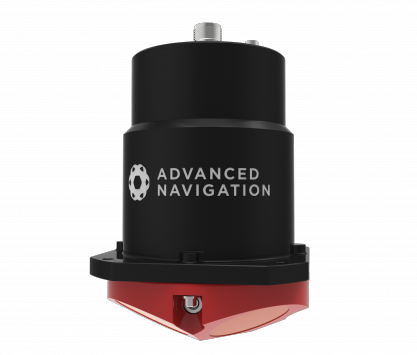
The Sublocus underwater inertial navigation system by Advanced Navigation features high-accuracy north-seeking fiber-optic gyroscopes and accelerometers with a GPS receiver and pressure depth sensor, fused to deliver positional accuracy of 0.08 percent of distance traveled. The system also provides highly accurate roll, pitch, heading, heave, depth, and altitude.
Sublocus is also available with an integrated RDI Workhorse Navigator DVL for combined acoustic and inertial navigation in the one product. Both models are supplied with a subsea GPS antenna and are rated to 3,000 meters depth.
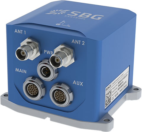
SBG Systems has added a new inertial system to its Ekinox Series. With integrated Dual Antenna GPS + GLONASS receiver, the Ekinox-D is a ready-to-use survey-grade inertial navigation system that provides consistent true heading (0.05°), SBG Systems said.
The Ekinox-D is a high-performance inertial navigation system that embeds a dual-antenna L1/L2 GNSS receiver to deliver more robust heading and position, while increasing satellite reception availability. Ekinox-D is an integrated system: GNSS data and inertial information are fused by an Extended Kalman Filter (EKF) to improve data integrity. This computation allows the system to achieve 0.05° roll, pitch, and true heading; 5-cm heave; and 2-cm RTK GNSS position.
The Ekinox-D is an all-in-one Solution for demanding applications. Instead of mounting separate GNSS receiver and inertial systems on a boat, car, or plane, the Ekinox-D can be installed and connect it to a camera, SONAR, or LiDAR system. With its 8-GB datalogger and its high output rate (200 Hz), Ekinox-D joins simplicity and performance for applications where robust heading is required such as surveying and hydrographic applications, unmanned system navigation, and auto testing.
The IP68 Ekinox Series brings robust, maintenance free, and cost-effective MEMS to the next level thanks to a drastic selection of high-end MEMS sensors, an advanced calibration procedure, and powerful algorithm design, SBG Systems said, adding that compromise is no longer required between high accuracy and cost.
Hemisphere GNSS has launched its new Crescent Vector H200 GNSS compass module, a high-performance receiver for heading, positioning, heave, and attitude. Vector H200 is designed for professional marine, navigation, and land applications in challenging and dynamic environments.
Vector H200 processes L1 GPS and GLONASS signals to deliver precise heading, greater positioning reliability, and better performance in challenging environments, Hemisphere GNSS said. Through using two separate antennas, Hemisphere GNSS’ patented Vector technology computes the heading and pitch or roll angle while stationary or in motion. Vector H200 can compute heading accuracy to 0.02 degrees using a 5-meter antenna separation. A variety of differential correction methods also make it possible for Vector H200 to provide sub-meter to centimeter position accuracy.
Marine industry developers can maximize performance by integrating Vector H200 into their systems for hydrographic and bathymetric surveys, auto-pilots, dredging, and buoys. For land applications, Vector H200 is ideal for aligning cameras, antennas and projectiles, and for machine control applications in agriculture, construction, and mining.
“System integrators have a lot to gain from Vector H200’s powerful combination of navigation and machine control orientation capabilities,” said Ron Ramsaran, Sr. Product Marketing Manager at Hemisphere GNSS. “They will appreciate the performance and value from such a small board package.”
Vector H200 supports SBAS, L-Band and RTK differential positioning solutions and features our exclusive SureTrack technology optimizing the use of GPS and GLONASS signals. Hemisphere GNSS offers precise GNSS antennas to fit a variety of Vector H200 applications.
C-Nav, supplier of international GNSS Precise Point Positioning services, has launched its latest GNSS real-time tide measurement package, C-Tides.
The C-Tides suite combines the vertical accuracy of C-Nav’s GNSS Precise Point Positioning service with the latest advanced ocean and coastal tides models, the company said.
C-Tides Online features real-time filters and vessel dynamics, a choice of worldwide Mean Sea Surface or regional reference frame models, and tidal prediction for mission planning.
C-Tides Offline utilities include data smoothing and outlier rejection, harmonic analysis, Doodson X0 filter, and a LAT option.
“It’s been a privilege working with our academic partners to develop what is probably the worlds’ most advanced real-time GNSS tide solution,” said Russell Morton, C-Nav head of development.
C-Tides is a fully supported C-Nav utility. The results are suitable for combining with other suitably calibrated vertical components to achieve IHO SP44 Order 1 or better.
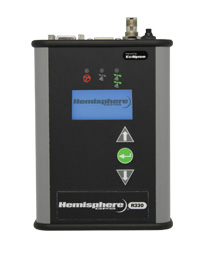
Hemisphere GNSS has rolled out the R330 GNSS receiver, a versatile, fully featured positioning system. R330 delivers accurate and robust positioning through a variety of differential correction methods including SBAS, L-Band, Beacon and RTK, the company said. With its wide range of functionality and ease of use, the R330 is suitable for a variety of land and marine applications.
The R330 GNSS receiver combines the functionality and front panel display of all previous R-series products. Customers can start with sub-meter positioning accuracy and upgrade the receiver with subscriptions that add functionality and improves performance capability to centimeter-level accuracy. To provide the most reliable solutions, R330 is capable of tracking multiple frequencies and multiple constellations including GPS and GLONASS. Users can easily switch between the various DGPS correction options without any downtime. The R330 GNSS receiver is compatible with many of the Hemisphere GNSS’ multi-frequency antennas.
The small, rugged receiver includes a display and status indicators for a user-friendly experience, Hemisphere GNSS said. A standard USB flash drive can be used for data logging.
“The functionality and performance of the R330 receiver can be custom-fit to positioning applications such as pipeline, marine, and volumetric surveys, GIS mapping, vehicle tracking, machine control, meter monitoring and many others,” said Ron Ramsaran, senior product marketing manager at Hemisphere GNSS. “R330 customers will benefit from the reliability, value, and upgrade options that can be added to meet changing needs.”
R330 features Hemisphere GNSS’ exclusive Eclipse SureTrack technology, enabling a more robust RTK solution with fewer dropouts in congested environments and a fast reacquisition when dropouts do occur. Long-range RTK baselines of up to 50 km are achievable with R330.
The R330 GNSS receiver will be available in June through the Hemisphere GNSS Precision Products global dealer network.
Topcon Positioning Systems has released the MR-1 Heading System, an OEM GNSS solution for high-performance positioning and heading.
Using the MR-1 receiver and Topcon’s MG-A8 antenna, the system provides “centimeter-accurate RTK positioning and better than 1/10 of a degree heading accuracy in challenging environments,” said Doug Langen, TPS GNSS product manager. “The rugged MR-1 receiver is water and dustproof and operates at a robust operational temperature range of -40°C to 75°C.”
When combined with Topcon’s Quartz Lock Loop technology, the MR-1 offers continuous operation during “extreme vibration and shock, typical of intense dynamic environments,” he said.
The MG-A8 antenna of the MR-1 Heading System is designed for moving platforms and provides multipath rejection. It also offers increased resistance to near-band interference from satellite communications systems commonly found in marine applications.