Tag: marine

  • Cobham Launches Two ‘Sailor’ Marine Receivers

    Cobham Launches Two ‘Sailor’ Marine Receivers

    SAILOR 6560 GNSS_500x500
    The Sailor 6560 GNSS System is delivered with the Sailor 6004 Control Panel and the corresponding Sailor 6285 GNSS Antenna or Sailor 6286 DGNSS Antenna.

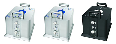
    Cobham SATCOM has launched two new Sailor satellite navigation receivers. Both the Sailor 656X GNSS and new Sailor 657X DGNSS (Differential GNSS) are black-box products designed to be part of a system Cobham SATCOM refers to as its “multi-function universe.”

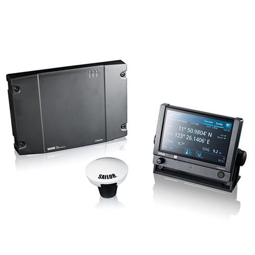
    The advanced touchscreen Sailor 6004 Control Panel at the heart of the Multi-Function Universe provides full control for all products connected to it from a single device. The Sailor 656X GNSS and Sailor 657X DGNSS join the Sailor 6391 Navtex and Sailor 628X AIS as new generation Sailor products designed to work with the Sailor 6004 Control Panel. Operation of all systems connected to the Sailor 6004 Control Panel is done by selecting the icon for the product on the touchscreen, providing access to set-up, functions and diagnostics.

    “The Multi-Function Universe approach means that a variety of products can all be accessed from a single screen on the bridge and anywhere else a repeater is needed, making installation far more flexible than with traditional products that all require their own screen. The approach also saves space on the bridge, and importantly, makes the life of maintenance engineers easier as they have a single point of entry to the network,” explains Claus Hornbech, Business Manager, Cobham SATCOM.

    The Sailor 656X GNSS and the Sailor 657X DGNSS collect satellite data from any available navigation satellites including GPS and GLONASS and distribute it to a variety of on board systems such as; ECDIS (Electronic Chart DISPlay System), INS (Integrated Navigation System), GMDSS (Global Maritime Distress & Safety System), SATCOM (Satellite Communication System), MCS (Master Clock Systems) and PABX (Telephone Exchanges).

    Cobham SATCOM offers four variants of its new satellite navigation products, all of which are designed 100% in house. The Sailor 6560 GNSS System and Sailor 6570 DGNSS System are delivered with the Sailor 6004 Control Panel and the corresponding Sailor 6285 GNSS Antenna or Sailor 6286 DGNSS Antenna, while the Sailor 6561 GNSS Basic and Sailor 6571 DGNSS Basic are delivered with the antennas only.

    All four variants use the same proprietary Sailor 6588 DGNSS Receiver, which provides highly accurate data, enhanced by means of Satellite Based Augmentation System (SBAS) from various areas including WAAS (Wide Area Augmentation System) for the United States, EGNOS (European Geostationary Navigation Overlay Service) in Europe, and systems from Japan, India and Russia. The Sailor 6285 GNSS Antenna and Sailor 6286 DGNSS Antenna are also both new, designed and manufactured according to Cobham SATCOM’s quality standards.

    “The accuracy and availability of satellite positioning and timing data is vital to vessel safety as so many critical navigation and communication systems rely on it to operate,” adds Jan Kragh Michelsen, VP Maritime Business Development, Cobham SATCOM. “All elements, from the black-box to the antennas, multi-function display and the user-interface of the systems are new and developed 100 percent in house at Cobham SATCOM, so customers can be confident in the reliability of our new GNSS and DGNSS products, in addition to our revolutionary Multi-Function Universe operating concept.”

  • Septentrio Launches AsteRx-U and AsteRx-U Marine

    AsteRxU_left_orientation-W

    Septentrio this week is launching two successors to its APS-U: The AsteRx-U and the AsteRx-U Marine multi-constellation dual-antenna receivers. The AsteRx-U will be presented to the public for the first time at two trade shows this week. ION GNSS+ takes place Sept.14-18 in Tampa, Fla., and INTERGEO 2015 will be held in Stuttgart, Germany, Sept. 14-18.

    The AsteRx-U and the AsteRx-U Marine incorporate the latest GNSS tracking and positioning algorithms and interference mitigation. Machine-control users in the agricultural and construction industries, as well as users in marine and mining industries, benefit from a complete system with integrated UHF radio, Wi-Fi, USB, Bluetooth and cellular connectivity and a spectrum analyzer, Septentrio said. All configurations can be done via the on-board web interface.

    The AsteRx-U and AsteRx-U Marine feature a full range of positioning techniques and algorithms to ensure that users have the highest accuracy and reliability. The spectrum analyzer enables users to visualize the RF spectrum. Based on its extensive experience with real-life interference sources and their mitigation, Septentrio has developed interference mitigation technology that automatically counteracts various kinds of ambient intentional and unintentional RF interference.

    The AsteRx-U family of receivers is built around Septentrio’s latest ASIC, GReCo4, which was introduced in 2014. It incorporates built-in jamming detection and countermeasures, multi-path rejection, fast acquisition and other advanced features. Both receivers have more than 500 hardware channels to track all available constellations (GPS, GLONASS, Galileo, Beidou, IRNSS and QZSS) and feature many algorithms: LOCK+ technology to maintain tracking during heavy vibration machine use and IONO+ technology to assure the accuracy of the position even in regions of elevated ionospheric activity.

    The AsteRx-U has decimeter- and centimeter-level RTK positioning including TerraStar. The AsteRx-U Marine also supports Veripos PPP augmentation services. It includes extra anti-jamming technology to counter Iridium and INMARSAT-uplink interference, as well as an extra antenna connector for a dedicated L-band antenna to optimize L-band reception at high latitudes.

    Straightforward to set up and integrate with existing systems, the AsteRx-U and AsteRx-U Marine use any device with a web browser to facilitate usability and configuration for the user.

    “We want to make it easy for our customers to use high-accuracy positioning in their work,” said Jan Leyssens, Septentrio product manager. “Using the integrated communication functionality in the compact and portable AsteRx-U, users won’t have to worry about adding their own modems or UHF radios to get access to corrections.”

    Leyssens continued, “The receiver web interface is available wirelessly on any mobile device. It was designed together with several of our key customers, resulting in an interface that is not only easy to use by field operators, but also provides many useful troubleshooting tools, such as the spectrum analyzer, to solve problems in the field and minimize downtime.”

    Septentrio will be at Booth 318 at ION GNSS+, and at Hall: 4, Booth: D4.014, at INTERGEO.

  • NDGPS Destined for the Technological Boneyard

    Let us not exaggerate — nor prematurely announce — the death of a subsystem. However, the demise of the U.S. Nationwide Differential GPS (NDGPS) network can be confidently foretold. Although a Federal Register notice dated Aug. 18 merely seeks public comment on plans to shut down a large portion of NDGPS, the handwriting is on the wall. Once having writ, the hand of fate moves on.

    We should neither lament nor applaud. NDGPS, like many other technologies, has seen its time come and go, while competitors have arisen to perform its role and take its place. Such is evolution in the industrial world as well as in the biological kingdoms.

    In 2016, three quarters of the currently operating NDGPS reference stations will be taken down and decommissioned. That’s not what the federal notice states, but that’s what it effectively says. The document’s comment period ends on Nov. 16. It is difficult to conceive of a public outcry that might reverse the intended course of the U.S. Coast Guard, Department of Transportation and Army Corps of Engineers.

    The NDGPS network had its birth in the 1980s, as a tool to provide real-time positioning accuracy for harbor entrances and coastal navigation. Inland components were added over the years to improve river navigation, NDGPS use in precision agriculture began to grow, and a role in railroad positive train control (PTC) was much discussed. But all these efforts could not gather enough momentum to firmly establish the network’s viability. Meanwhile, satellite-based differential services from both commercial providers and the U.S. government’s own Wide Area Augmentation System (WAAS), and a network of continuously operating reference stations (CORS) from the National Geodetic Survey continually nibbled away at NDGPS’s potential customer base. Consequently, industry fielded a meager range of radiobeacon DGPS receivers.

    The real death blow came in 2013, when the Federal Railroad Administration (FRA) eliminated an NDGPS requirement from its PTC program. The railroads, never a nimble industry nor one receiving the governmental support it enjoys in other countries, had by that time become the last hope of NDGPS. Ag users had already for the most part moved over to WAAS and commercial SBAS providers. Marine users did not by themselves form a sufficiently large constituency, and even they were not fully equipped nor wholesale adopters of the system.

    The story of Loran bears some similarities to NDGPS, but Loran now enjoys a resurgence that NDGPS will never see. It is destined for the technological graveyard. There is an ecosystem of positioning, navigation and timing (PNT) tools and applications. Operating in a free market, with some measure of governments’ interference and manipulation, it has its own patterns of natural selection. We will continue to see the rise and fall of species. NDGPS has now been branded a dinosaur. It will be interesting to see how other technologies, competing for the same finite range of resources, will interact, thrive, or decline.

  • Harris, exactEarth Form Alliance for Global Maritime Tracking

    exactEarth Ltd. and Harris Corporation have formed an alliance to provide a new level of Satellite Automatic Identification System (AIS) data service that will deliver real-time global coverage for maritime vessel tracking. The new service will leverage the persistent global coverage and real-time connectivity of the Iridium NEXT constellation through the implementation of 58 hosted payloads covering the Maritime VHF frequency band.

    Harris is a space, geospatial and remote sensing company, and exactEarth is a provider of AIS data services.

    Compatibility testing of the hosted payload with the Iridium satellites has been completed. The first launch is scheduled for early 2016, with the completed constellation expected in 2017. The new service will provide customers with the fastest, most accurate vessel information available. With revisit times and latency under one minute, the service expansion represents a leap forward in the ability for both Harris and exactEarth to offer global ship tracking and maritime information solutions, the companies said in a statement.

    The alliance leverages exactEarth’s proven and patented signal de-collision detection technology and Harris’ expertise in satellite hosted payloads, advanced radio frequency technology and antenna solutions. Harris becomes the exclusive provider to the US government of AIS products and services produced under the alliance, including exactEarth’s exactAIS product portfolio, while exactEarth continues to serve all other global markets.

    “This alliance will expand our IntelliEarth family of innovative solutions, which leverage Harris’ world-class remote sensing capabilities to help customers around the globe make smarter operational and business decisions,” said Bill Gattle, vice president and general manager, National Programs, Harris Government Communications Systems. “Harris is committed to exploring new technologies and partnering with world-leading organizations to provide our customers with the greatest value.” 

    “As the recognized Satellite AIS industry leader, this announcement further strengthens our commitment to provide best-in-class maritime intelligence solutions to our customers worldwide,” said Peter Mabson, Ppresident of exactEarth.  “We are thrilled to be able to offer the shortest revisit times and lowest latency for developing true maritime domain awareness. This partnership with Harris will allow us to significantly expand the range of advanced value-added services and information solutions that we can bring to the global maritime market.”

  • DeepOcean Hires Fugro for Fleet Positioning

    DeepOcean Hires Fugro for Fleet Positioning

    Credit: DeepOcean/Fugro
    Credit: DeepOcean/Fugro

    Fugro has been awarded a contract by subsea contractor DeepOcean for the provision of precise satellite positioning for its fleet.

    The contract is valid for three years and also includes the new vessels in DeepOcean’s expanding fleet. The DeepOcean fleet will be equipped with hardware and software developed by Fugro, providing independent positioning solutions on each vessel.

    Under the contract, Fugro will supply DeepOcean with three independent decimeter-level satellite navigation systems. Also part of the contract delivery are Fugro’s Starfix.G2+ system, which has a 3D accuracy approaching that of GNSS RTK systems, and Fugro’s Starfix.G4 satellite correction service.

    Starfix.G2 is a GPS and GLONASS positioning system based on orbit and clock corrections generated from Fugro’s own expanded network of dual system reference stations. Starfix.G2 is a precise point positioning (PPP) technology, which distinguishes itself from the traditional differential approach as satellite errors are not lumped together but estimated per source, per satellite. The GPS/GLONASS orbit and clock corrections are computed separately, free of ionospheric and tropospheric effects.

    Starfix.G4 is a GPS, GLONASS, Galileo and BeiDou positioning system based on orbit and clock corrections generated from Fugro’s network of reference stations. Like Starfix.G2, Starfix.G4 also uses PPP technology. The GPS/GLONASS/Galileo/BeiDou orbit and clock corrections are computed separately, free of ionospheric and tropospheric effects.

    DeepOcean is an integrated provider of services and technologies for the subsea industry, including offshore services for oil and gas, offshore renewables and electrical power transmission industries, with offices in Norway, UK, Holland, Brazil, Mexico and Singapore.


  • NovAtel Offers Marine Antenna that Blocks Inmarsat Interference

    NovAtel Offers Marine Antenna that Blocks Inmarsat Interference

    GPS-713 pinwheel antenna.
    GPS-713 pinwheel antenna.

    NovAtel Inc. has introduced the GPS-713 pinwheel antenna, available in two configurations: the standard GPS-713-GGG-N and the L-Band capable GPS-713-GGGL-N. 

    Both antennas provide enhanced Inmarsat interference rejection, allowing tracking of GNSS signals in the presence of high-powered Inmarsat transmitters typically found on marine vessels. The antennas receive GPS L1, L2, L5; GLONASS L1, L2, L3; BeiDou B1, B2; and Galileo E1, E5a/b frequencies, optimizing global satellite tracking capabilities. Customers can use either antenna for GPS-only or multi-constellation applications, providing excellent flexibility and reduced equipment costs, NovAtel said.

    Designed for baselines of any length and easy installation, the phase center offset of these antennas remains constant as the azimuth and elevation angle of the satellites change. The antenna shares the same form factor as other NovAtel GPS-700 series antennas, and is enclosed in a durable, waterproof housing.  Its compact, lightweight size makes it suitable for a wide variety of environments and applications.

  • Applanix Unveils Expanded Marine Product Portfolio

    Applanix Unveils Expanded Marine Product Portfolio

    Applanix has introduced an expanded portfolio of marine georeferencing and motion compensation solutions. Taking advantage of Applanix proprietary technology, the new line-up of marine products offers high-performance solutions to a broader cross-section of the hydrographic survey industry.

    All Applanix Marine products benefit from the optimal integration of GNSS and inertial observables, with access to Trimble GNSS technology for performance advantages.

    The Applanix POS MV Surfmaster.
    The Applanix POS MV Surfmaster.

    The announcement was made at Ocean Business 2015, an exhibition of more than 300 of the world’s leading manufacturers and service providers in the industry.

    “Advances in Applanix inertial technology enable us to offer the high performance levels we are known for at even more attractive price points. By introducing this new product portfolio, we are able to deliver solutions suited to all types of bathymetric mapping,” said Peter Stewart, director of Marine Products. “This revised product lineup demonstrates Applanix’ continued commitment to provide customers with options that best fit their budget and requirements.”

    At the entry level of the expanded product portfolio, Applanix introduced the new POS MV SurfMaster. Incorporating Applanix’s proprietary SmartCal inertial calibration techniques, POS MV SurfMaster delivers robust georeferencing for small platforms, both manned and unmanned. SurfMaster is fully supported by Applanix’ post-processing software POSPac MMS, and can deliver roll and pitch accuracy to 0.03 degrees, regardless of latitude or rate of vessel motion.  

    Applanix’ new marine product lineup also includes POS MV WaveMaster II and POS MV OceanMaster. Using newly developed inertial technology, POS MV WaveMaster II delivers performance equal to the well-established and proven WaveMaster E, but at a new lower price point. POS MV OceanMaster replaces the POS MV 320 E as the georeferencing and motion compensation solution of choice for the hydrographic professional, integrating next generation inertial sensors, which enable performance and pricing previously unavailable with this class of technology. POS MV OceanMaster provides reliable and robust surveying in even the most demanding sea conditions. POS MV Elite remains the ultimate option for users seeking the highest level of performance available to the industry.

    The new POS MV SurfMaster, POS MV WaveMaster II and the POS MV OceanMaster are available now worldwide through the Applanix sales channel.

  • Hemisphere GNSS Offers RTK-Capable Compass Antenna

    Hemisphere GNSS Offers RTK-Capable Compass Antenna

    The Hemisphere GNSS V320 GNSS compass.
    The Hemisphere GNSS V320 GNSS compass.

    Hemisphere GNSS is offering a new RTK-enabled Vector V320 GNSS compass. The Vector V320 smart antenna supports multi-frequency GPS, GLONASS, Galileo (future firmware upgrade required) and BeiDou, and Hemisphere GNSS says it’s “the first of its kind.”

    Designed for the professional marine and marine survey markets, the Vector V320 is the a multi-frequency, multi-GNSS, all-in-one smart antenna capable of both RTK-level positioning accuracy and better than 0.2-degree heading accuracy in a simple-to-install package.

    “The Vector V320 combines our expertise in GNSS and smart antenna design,” said Lyle Geck, senior manager, Product Marketing, at Hemisphere GNSS. “With RTK performance that competes with current industry leaders, extremely accurate accelerometer-aided GNSS heading, and the simplicity of install offered by the smart antenna design, it is an incredible product.”

    The Vector V320 is the latest in a line of GPS/GNSS compasses, including the multi-frequency, multi-GNSS Vector VS330 receiver as well as the Vector V102, Vector V103 and Vector V104 compass smart antennas.

    “There has been a void in the market. Our customers have been looking for a product that provides RTK accuracy together with precision heading in an easy-to-install package,” said Andy Smith, managing director of Saderet Ltd. “The Vector V320 delivers.”

    The Vector V320 GNSS compass is being featured by Hemisphere GNSS at Ocean Business in Southampton, UK, April 14-16, at stand K12.

  • iXBlue Launches Marins M Series Inertial Nav System

    iXBlue Launches Marins M Series Inertial Nav System

    The MARINS M series INS by iXBlue.
    The Marins M series INS by iXBlue. Photo: iXBlue

    iXBlue unveiled its Marins M series inertial navigation system (INS) at EURONAVAL 2014, held October 27-31 in Paris, France. The series includes the Marins M3, M5 and M7 systems and is designed to address the needs of the world’s most advanced navies for surface-vessel and submarine operations close to shore and in open-sea environments.

    Accurate and reliable navigation, including missile alignment, is critical to the success of submarine and surface-vessel missions. The Marins M series raises the bar in performance and scalability by addressing the needs of surface ship navigation under a GPS-denied environment. For submarines, Marins M7 enables three times longer autonomous stealth navigation compared with any available system by offering drifts of less than 1 Nm/72 h.

    The Marins M series represents the state of the art in strap-down, fiber-optic gyroscope (FOG) technology, and is combat-ready against GNSS denial, iXBlue said. The military-specification units output position, heading, roll, pitch, depth and velocities, and are perfectly silent. The systems are compatible with a wide range of aiding sensors and can be up and running within minutes.

    The extended iXBlue product range, including Quadrans, Octans, Phins and Marins M series systems, now represents even higher scalability of solutions, from attack craft to aircraft carriers and submarines.

    More than 30 navies worldwide have selected the iXBlue product range, including previous generations of Marins systems. For example, the UK Royal Navy has adopted advanced iXBlue solutions for its Astute Class submarines.

  • Hemisphere GNSS Offers New Survey-Grade GNSS Antennas

    Hemisphere GNSS Offers New Survey-Grade GNSS Antennas

    The A25 and A45 antenna. Photo: Hemisphere GNSS
    The A25 and A45 antennas. Photo: Hemisphere GNSS

    Hemisphere GNSS has announced two low profile, multipurpose antennas that it says will exceed expectations in all GNSS applications. With unique filtering patterns and precise attention paid to mitigation of multipath and interference, the A25 and A45 antennas complement all GNSS products, from L1 GPS to multi-frequency, multi-constellation.

    Both antennas are being featured at the InterGeo 2014 Conference and Trade Show in Berlin this week, at stand C2.007.

    The A25 and A45 have been designed to support millimeter accuracy for land and marine applications. Both antennas support present and future GNSS signals, including GPS, GLONASS, BeiDou, QZSS, and Galileo. The A25 supports the previously mentioned signals at a single-frequency level, while the A45 supports these signals at a multi-frequency level.

    “We’ve designed these antennas to excel in challenging environments such as near buildings or under foliage,” said Lyle Geck, senior manager of product marketing at Hemisphere GNSS. “They have superior multipath mitigation, stable phase centers and strong SNR’s, even at low elevations.”

    The ruggedized housing used by both antennas is made of an aluminum base that has been pretreated for the marine environment and will withstand salt, fog, and spray. The antennas pass the two-meter pole drop test.

    The A25 is a multi-GNSS precision antenna, designed for a variety of applications including GIS, single-frequency RTK positioning and navigation, and precision guidance. The A45 is a survey-grade, multi-GNSS precision antenna for a variety of applications including surveying, RTK positioning and navigation, precision guidance, and machine control.

    For more information about Hemisphere GNSS’ antennas and other products, please visit www.hgnss.com/Products-Solutions.

  • Satlab Geosolutions Adds Americas Office, Appoints Phil Gabriel

    Satlab Geosolutions Adds Americas Office, Appoints Phil Gabriel

    Satlab products include (from left) the SL600 6G GNSS receiver, the SL300 6G GNSS receiver, and the SL55 controller. Photo: Satlab Geosolutions AB
    Satlab products include (from left) the SL600 6G GNSS receiver, the SL300 6G GNSS receiver, and the SL55 controller. Photo: Satlab Geosolutions AB

    Swedish-based survey and GIS equipment maker Satlab Geosolutions AB has expanded into the U.S. and Americas with the creation of a new sister company Satlab Geosolutions (USA), Inc., based in Scottsdale, Arizona. Phil Gabriel has been named managing director of the USA office.

    Setting up a formal base of operations in the U.S. will allow Satlab to better service their clients and expand their customer base in the U.S., Canada, Mexico and Latin America, a company release said. As past president of Hemisphere GNSS, Gabriel brings to the team his many years of experience in the survey, GIS, GNSS, machine control, marine and navigation industries, Satlab said.

    The U.S. location will sell, support and service the new product lineup being introduced at InterGeo in Berlin, Germany, on October 7.  Satlab is seeking dealers to expand its business throughout the Americas.

    “The addition of a U.S. office is an exciting next step for us, after successful expansion into Turkey and the Czech Republic in the last few years,” said Bjorn Agardh, CEO of Satlab Geosolutions AB.

    “Our products have been well received and continue to perform extremely well,” added Birol Gucluer, CTO and partner of Satlab.

    “I’m excited to join Bjorn and Birol, extending their success by ensuring their high standards in customer service are maintained here in the Americas,” Gabriel said.

    Satlab invites Survey and GIS dealers to meet the expanded team at InterGeo October 7-9 in Berlin, where they will be introducing several new models of their popular receivers and handhelds.

  • Royal Institute Hosts New Navigation Conference

    Royal Institute Hosts New Navigation Conference

    INC_2015_logoThe Royal Institute of Navigation is launching a new international conference series, tackling some of the biggest issues across the domains of modern navigation: land, sea, air and space.

    The RIN is now accepting abstracts for the conference.

    The International Navigation Conference 2015, set for February 24-26, 2-15, is planned as a first event in a new series of world-class conferences. The first conference will highlight the state of the art in fields such as GNSS and Galileo, indoor positioning, autonomous transport, security and resilience of navigation in the world of cyber attacks, and new quantum technologies. The event will be of special interest to the maritime, aviation, PNT, transport, research and development and security communities.

    Speakers, and the topics they will discuss, include:

    • Privacy In Tracking (smartphones and indoor navigation) – Google
    • Security and resilience — Dana Goward, president and executive director, U.S .Resilient Navigation and Timing Foundation
    • Multi-Constellation GNSS — Gian Gherado Calini, GSA
    • Multi-Sensor Integration — Professor Dorota Grejner-Brzezinska, The Ohio State University
    • Quantum Technologies — Sir Peter Knight, professor of Quantum Optics and Senior Research Investigator, Imperial College London
    • Emerging Trends and Current Challenges — Colin Beatty FRIN, CBiL
    • Autonomy in transport — BAE, ASTREA
    • Legal Aspects of Navigation — Professor Frans von der Dunk, Institute of Space Law, Leiden University

    To learn more, visit the conference website.