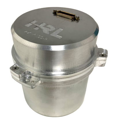
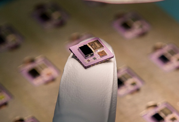
HRL Laboratories has introduced a new inertial measurement unit (IMU) that provides near navigation-grade accuracy in a palm-sized package.
Smaller and lighter than grade-equivalent conventional sensors, HRL’s AXI-R100 delivers range-extending accuracy for GPS-contested navigation. The product is now ready for pre-production orders.
Using silicon microelectro-mechanical systems (MEMS) technology, HRL’s gyros exceeds the performance of many tactical-grade IMUs in the same or smaller package size, and is manufactured in high volumes at wafer-scale. This near navigation-grade performance is available at a tactical-grade price.
The new IMU is suitable for use in defense, aerospace and automotive applications, including missile-guidance systems and drone navigation, as well as for commercial automotive applications with higher levels of autonomy. The product is ready for integration as it has been designed and tested against challenging vibration, shock and thermal conditions representative of those applications.
HRL will present product specifications at the 2026 Joint Navigation Conference, taking place this week in Cincinnati, Ohio, and is exhibiting in booth 129.
By leveraging high volume design automotive methodologies, HRL designed AXI-R100 navigation sensors to scale for high-volume automotive demand while maintaining performance superiority over traditional tactical-grade sensors. The result is a gyroscope compatible with foundry fabrication processes for high volume applications.
“Our gyroscopes and inertial sensors support navigation, pointing and stabilization systems for autonomous vehicles, aircraft and guided missile and munition applications,” said Jeff Dickman, director, Precision Sensing, HRL Laboratories. “We leveraged our extensive microelectronics legacy along with innovations in micromechanical and manufacturing processes to pave the way for AXI-R100 to address the urgent needs from our industrial base.”
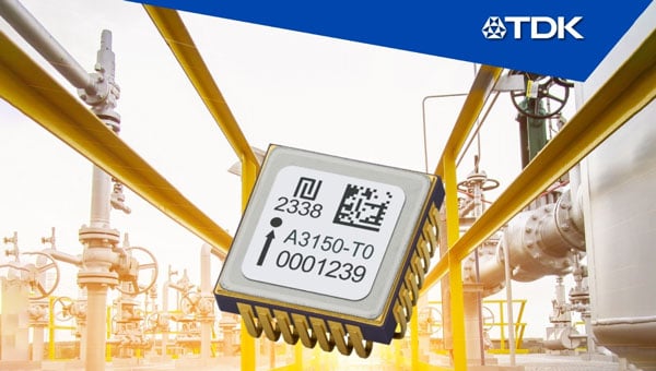
TDK Corporation has introduced the Tronics AXO315T0, a high-temperature MEMS accelerometer designed for measurement while drilling (MWD) applications in the energy sector. The new sensor features a ±14 g input range and a digital interface, expanding TDK’s MEMS inertial sensor portfolio.
The AXO315T0 uses TDK’s closed-loop architecture, which delivers advanced vibration rectification and resistance to operational shocks. The device maintains a bias residual error of 0.8 mg across its operating temperature range of minus 30°C to 150°C, enabling precise and continuous inclination measurements for directional drilling tools exposed to high temperatures.
To meet the demanding reliability requirements of complex drilling operations in harsh environments, TDK qualified the AXO315T0 through more than 1,000 hours of powered life testing at 165 degrees Celsius, temperature cycling from minus 55 degrees Celsius to 165 degrees Celsius, and high-temperature vibration tests at 20 g RMS random vibration combined with a 50 g sine sweep.
The AXO315T0 offers a typical bias drift of less than 1 mg without recalibration after 1,000 hours at high temperature, providing a digital, low size, weight and power (SWaP) alternative to traditional quartz accelerometers. This advancement supports a new generation of MWD tools capable of long-term operation at elevated temperatures without compromising performance.
AXO315T0 sensors and evaluation boards are available for sampling and customer evaluation. TDK plans to further expand its MEMS portfolio for the energy market with a new accelerometer capable of operating at temperatures up to 175 °C.
Main applications:
Measurement while drilling (MWD)
Logging while drilling (LWD)
Directional drilling
Wireline
Key features and benefits:
±14 g input range, single-axis accelerometer
Operating temperature range: minus 30 °C to 150 °C
In the mission-critical world of aerospace and defense, where reliability and resilience can mean the difference between success and failure, precision timing is an essential technology for increasingly sophisticated and connected systems. Every nanosecond matters, whether ensuring UAVs operate safely or enabling secure real-time communication in high-threat environments. At the heart of these systems is precision timing technology, which ensures precise synchronization within and between systems, enabling high data throughput with minimal latency.
Aerospace and defense systems operate in some of the harshest environments on the planet, where extreme temperatures, shock and vibration and electromagnetic interference (EMI) are commonplace. While quartz technology has historically been used to deliver timing references in aerospace and defense applications, precision timing based on microelectromechanical systems (MEMS) technology has recently proven to be a superior alternative due to its better performance, resilience and reliability.
To understand the key differences between MEMS and quartz technologies for timing devices used in aerospace and defense applications, let’s focus on size, weight and power consumption (SWaP), as well as the ability of these two distinct types of timing technologies to perform reliably and accurately in harsh, demanding operating environments.
The Rise of MEMS Oscillators in Aerospace and Defense
MEMS-based precision timing technology is proven and highly reliable, designed to perform reliably in the harsh environments in which aerospace and defense applications operate. Unlike quartz timing devices, MEMS-based timing devices such as resonators, oscillators and clock generators are manufactured using semiconductor processes. This silicon MEMS technology enables unparalleled miniaturization, better resilience, and higher performance across a variety of environmental conditions. By encapsulating a MEMS resonator in a vacuum-sealed cavity, these timing devices are protected from contamination, aging, and environmental disruptions such as shock and vibration.
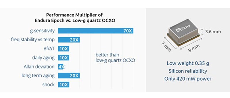
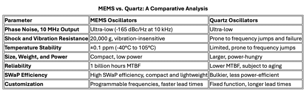
SiTime, a leader in MEMS-based precision timing technology, has developed a variety of MEMS-based oscillators and clocks that outperform quartz counterparts in key areas like stability, ruggedness, and SWaP. (See Figure 1.) These include popular devices such as temperature-compensated oscillators (TCXOs) and oven-controlled oscillators (OCXOs). The company’s MEMS-based Endura family of ruggedized Super-TCXOs and OCXOs, for example, is specifically designed for demanding aerospace and defense applications.
Figure 1. MEMS OCXOs surpass vibration-rated quartz OCXOs in performance, offering superior functionality with reduced SWaP. (Credit: all photos and tables provided by author)
Key Advantages of MEMS Precision Timing Devices
Low Phase Noise: MEMS Super-TCXOs deliver ultra-low phase noise, even in the presence of environmental stressors such as shock, vibration, and rapid temperature changes, which is essential for high-frequency RF systems such as tactical radios and satellite communication terminals. With low phase noise at 10 MHz output frequency of -165 dBc/Hz at 10 kHz offset and -175 dBc/Hz noise floor, these MEMS oscillators outperform typical quartz-based devices, ensuring cleaner signal transmission and better system performance.
Shock and Vibration Resistance: MEMS oscillators are qualified by SiTime to the highest MIL-STD-883 shock stress level of 30,000 g and customers have reported they can operate at 100,000 g shock levels. This extreme shock resistance in conjunction with ultra-low acceleration sensitivity, as low as 0.009 ppb/g total gamma, make them ideal for rugged environments including space missions, aircraft and military vehicles. In contrast, quartz oscillators are prone to failure or frequency jumps under similar conditions.
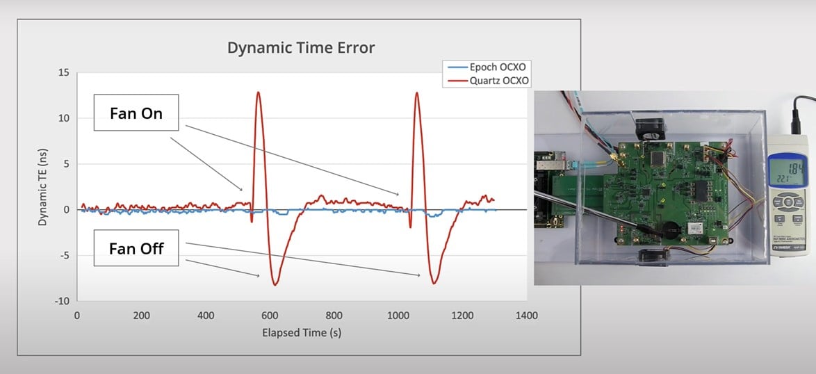
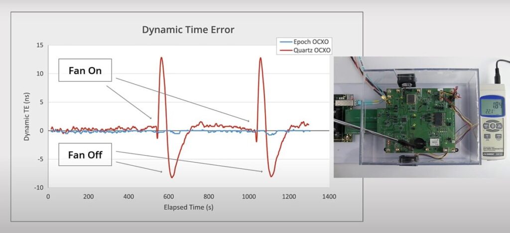
Temperature Stability: Super-TCXOs exhibit excellent temperature stability, with frequency stability of ±10 ppb across a temperature range of -40 °C to +105 °C. This stability is critical for aerospace and defense applications subject to rapid temperature changes, which cause traditional quartz oscillators to fail or experience frequency jumps. (See Figure 2.)
SWaP Efficiency: MEMS oscillators are significantly smaller, lighter, and more power-efficient than quartz devices, meeting the stringent SWaP requirements of modern aerospace systems. For example, OCXO-grade TCXOs (Elite-X) come in a compact 7.0 x 5.0 mm2 surface-mount package and consume less than 115 mW of power while delivering ±5ppb frequency stability over temperature performance. This makes them ideal for space-constrained, low-power applications like small satellites (SmallSats) and tactical communication systems.
Reliability: MEMS oscillators offer superior long-term reliability, with a mean time between failures (MTBF) of more than 1 billion hours – about 30 times greater than quartz-based oscillators. Additionally, MEMS devices exhibit lower aging rates than quartz, ensuring consistent performance over extended missions.
Figure 2. Endura Epoch OCXOs are unaffected by rapid temperature changes, as simulated by air flow that is turned on and off repeatedly.
Real-World Applications of Precision Timing Technology
Tactical Radios: Precision Timing is critical for secure data transmission in military communication systems. Super-TCXOs, offering low phase noise and vibration resistance, ensure signal integrity even in the harshest battlefield conditions, improving the reliability of tactical radios used by defense forces.
Satellite Communication Systems: Reliability, component size and power efficiency are paramount in satellite communications. MEMS oscillators enable high-bandwidth data transmission with minimal signal degradation, and their robust design ensures uninterrupted performance during mission-critical operations. Their small size and energy efficiency also make them ideal for space- and power-constrained satellite systems.
UAVs: UAVs are often deployed in dynamic environments where they are exposed to extreme temperatures and vibrations. MEMS oscillators, with their superior shock and vibration resistance, are a preferred timing solution for maintaining stable navigation and communications, ensuring UAVs can carry out their missions without interruption.
Radar Systems: Advanced radar systems depend on precise timing to synchronize signal processing, reduce interference, and optimize target detection. MEMS-based Precision Timing devices, with their high vibration resistance and temperature stability, deliver reliable performance in high-intensity environments, such as on naval vessels or fighter jets, where traditional quartz oscillators may struggle to maintain accuracy.
The Future of Precision Timing in Aerospace and Defense
As aerospace and defense systems become more advanced, the need for reliable precision timing solutions will continue to grow. MEMS-based oscillators, with their superior SWaP efficiency, rugged design, and inherent reliability, represent the future of Precision Timing technology in these critical sectors.
While quartz oscillators have served the aerospace and defense and industry for decades, MEMS technology is proving to be a more effective Precision Timing solution for next-generation systems. MEMS-based TCXOs and OCXOs are setting new benchmarks for Precision Timing, offering unmatched resilience, reliability, and performance in the most demanding environments.
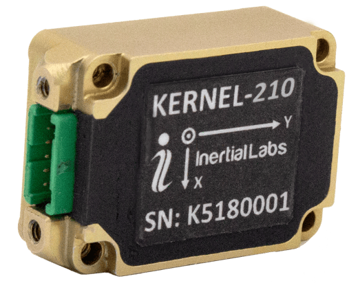
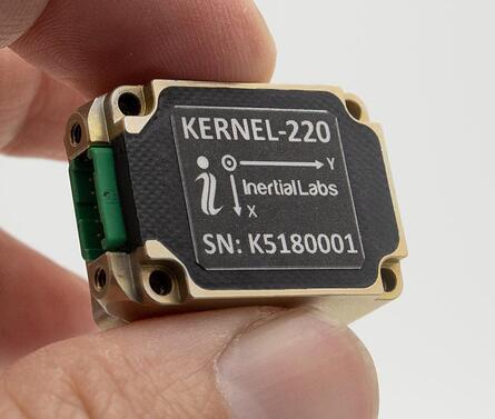
Inertial Labs has released its third generation of MEMS sensor-based inertial measurement units (IMU), MEMS KERNEL-210 and KERNEL-220.
The KERNEL-210 and KERNEL-220 are compact, self-contained, strapdown, tactical-grade IMUs that measure linear accelerations and angular rates using their aligned and calibrated three-axis MEMS accelerometers and three-axis MEMS gyroscopes.
Angular rates and accelerations are determined with low noise and good repeatability for both motionless and dynamic applications.
The KERNEL-220 model utilizes accelerometers with ±40g and ±90g measurement ranges. The IMU is fully calibrated, temperature compensated and mathematically aligned to an orthogonal coordinate system. The KERNEL-220 contains gyroscopes with a bias in-run stability of less than 1 deg/hr and accelerometers with an in-run stability bias of 0.005 mg.
Inertial Labs has announced new versions of its Kernel inertial measurement units (IMUs).
The Kernel 110, 120, 210 and 220 are a set of compact, self-contained, strapdown industrial-grade (100 series) and tactical-grade (200 series) IMUs that measure linear acceleration and angular rates with three-axis micro-electromechanical (MEMS) accelerometers and three-axis MEMS gyroscopes.
Fully calibrated, temperature compensated, mathematically aligned to an orthogonal coordinate system, the Kernel 210 and 220 contain 1 deg/hr bias in-run stability gyroscopes and 0.005 mg bias in-run stability accelerometers.
The new Kernel 110 and 120 IMUs will be superseding the existing Kernel 100 IMU. The Kernel 210 and 220 are miniaturized versions of the company’s IMU-P (Professional) tactical unit.
The Kernel series of inertial measurement units are a fully integrated inertial solution that combines the newest MEMS sensors technology. This seamless integration allows Inertial Labs to provide an inertial system with high performance while maintaining a high-value price point. With its compact design and low power consumption, the Kernel IMUs easily integrate in a wide range of higher order systems while consuming very little space and power.
With continuous Built-in Test (BIT), configurable communications protocols, electromagnetic interference (EMI) protection, and flexible input power requirements, the Kernel 110, 120, 210 and 220 are built to be used in a wide variety of environments and integrated system applications. Units have been thoroughly tested to perform in large variations in temperature, high vibration, and shock.
Designed to be used in air, marine and land environments, the Kernel series can be integrated into motion reference units (MRU), attitude and heading reference systems (AHRS) and GPS-aided inertial navigation systems (INS). As a result, Kernel IMUs are suitable for a wide variety of applications such as autonomous vehicles, antenna and line-of-sight stabilizations systems, as well as buoy or boat motion monitoring.
“The new Kernel IMUs represent the innovative approach at Inertial Labs,” said Jamie Marraccini, president and CEO of Inertial Labs. “The high performance and the flexibility to integrate into different systems and applications is what we have striven to provide to our clients with the new Kernel IMU release.”
A roundup of recent products in the GNSS and inertial positioning industry from the May 2022 issue of GPS World magazine.
SURVEYING
Measurement Workflows
Field-to-office inspection with survey-grade accuracy
Photo: Trimble
Trimble Access field software now connects with Infotech’s Appia service to streamline the workflow from survey to construction. Aimed at the inspection process for civil infrastructure projects, the software provides high-accuracy measurement workflows for daily work reports and inspection reporting for engineering, construction and public agencies. By streamlining the connection between data collected by Trimble GNSS rovers and simultaneously syncing Trimble Access, Infotech Mobile Inspector and Infotech Appia, inspectors can now complete their daily work reports more efficiently in the field and reduce errors. With manual processes removed, inspectors can more accurately represent infrastructure assets.
For surveying, mapping and construction professionals
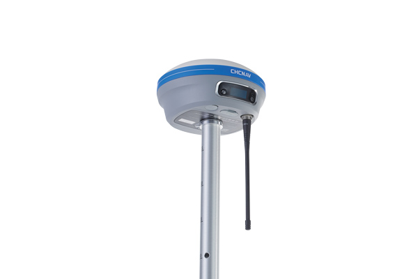
Photo: CHCNav
The i83 GNSS receiver is powered by a multi-band GNSS receiver, iStar technology, and a calibration-free, high-end inertial measurement unit (IMU) for faster and reliable field GNSS surveying. The third-generation high-gain antenna with advanced CHCNAV iStar algorithm improves GNSS satellite signal tracking efficiency by more than 30%. The i83 GNSS receiver features 1,408 GNSS channels for high performance across GPS, GLONASS, BeiDou, Galileo and QZSS constellations. Its onboard GNSS technology delivers centimeter-level positioning, maintains reliable fixed real-time kinematic (RTK) accuracy, and collects points faster than previous models, even in demanding conditions. The i83 receiver’s built-in IMU automatically compensates for pole tilt. In less than 5 seconds, the 200-Hz inertial module is initialized to ensure survey-grade accuracy over a pole-tilt range of up to 30 degrees. Productivity is dramatically increased, RTK usability greatly improved, and potential human error reduced, whether you are an engineer, site foreman or surveyor.
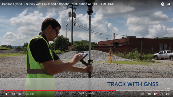
Simplifies surveying with both GPS and total station
Photo: Carlson Software
SurvPC Hybrid+ is a module for SurvCE version 6 software that enables surveying with mixed brands of GNSS receivers and total stations. SurvCE is a data-collection software package from Carlson Software. SurvPC Hybrid+ provides driver support for numerous devices, allowing the surveyor to interface with both types. Features include Follow Me, Smart Lock, Smart Staking, Cross Check, Backup Tracking, Hybrid-Resection, Auto-Localize, and Easy Setup Wizard.
SurPad 4.2 is designed to help surveyors work efficiently at all types of land surveying and road engineering projects in the field. It runs on eSurvey handhelds, Android smartphones and tablets, and third-party Android devices. It integrates with professional receiver control, point collection, stakeout, geographic information system (GIS) data collection, road measurement, road design, cross-section measurement and railway stakeout. SurPad 4.2 provides multiple operation and communication systems, has mapping and CAD functions, and has a coordinate system. It also includes a survey mode encompassing topo, control, quick point and COGO civil engineering programs.
The Leica AP20 AutoPole provides tilt compensation, automatic pole-height readings and unique target identification for automated total stations. It combines an intelligent sensor module with the AP Reflector Pole and operates with existing Leica Geosystems’ automated total stations to create a solution for autonomous workflows. Tilt compensation decreases measurement time and increases flexibility and safety on site by enabling measurement of points in inaccessible or risky locations. By updating the pole height automatically in the field software, the system ensures that the height on record is always correct.
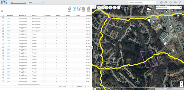
INSITE Data Reviewer moves geospatial data validation to the cloud, giving key stakeholders the ability to collaborate in real time. The third module in the INSITE Lifecycle suite of products, INSITE Data Reviewer provides reviewers real-time access to aerial imagery, lidar data and geographic information system (GIS) layers via the cloud to standardize quality control. This increases data validation speed and reduces costs of geospatial projects. The INSITE Lifecycle suite combines Project Tracker, Data Delivery and Data Reviewer modules through which users can see their projects executed on a map, from data acquisition through processing.
Eos Laser Mapping for ArcGIS is now available on Android devices. It allows mobile crews to capture high-accuracy laser offsets directly into ArcGIS Field Maps with Arrow Series GNSS receivers. The solution combines technology from geographic information system (GIS) provider Esri, laser rangefinders from Laser Tech, and Eos’ own Arrow Series GNSS receivers. The release supports three workflows: standard laser offset (range-azimuth), range-range (range-intersect) and range-backsight (a total station-like method).
The MV60 micro-electromechanical system (MEMS) accelerometer delivers high performance and reliability in a small, rugged and low-cost package. The MV60 measures the acceleration experienced by an object during movement and is designed for use in inertial measurement units and navigation systems deployed on land, air and sea vehicles to measure velocity. It has a compact footprint of 1.2 square inches and shock survivability of up to 5,000 g. It also offers bandwidth of greater than 300 Hz — important for environmentally demanding missions.
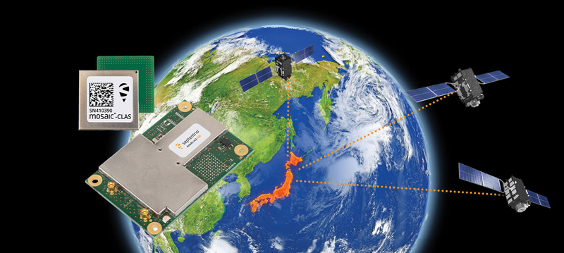
Receivers support Japan’s cm-level augmentation service
Photo: Septentrio
Three multi-frequency GNSS receivers now support the Centimeter-Level Augmentation Service (CLAS), receiving the L6 signal that transmits high-accuracy corrections from Japan’s QZSS constellation. The mosaic-CLAS receiver is in a small form-factor suitable for high-volume industrial applications. The AsteRx-m3 CLAS OEM board combines PPP-RTK CLAS with dual-antenna heading functionality. The AsteRx SB3 CLAS features a ruggedized IP68 enclosure to protect it in harsh environments.
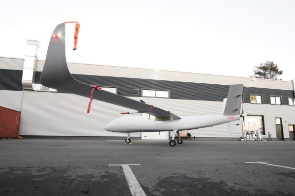
The S1-V300 medium-altitude long-endurance (MALE) unmanned aerial system (UAS) prototype is based on the Saker MALE UAS design that achieved operational capability in 2020. The prototype features a new design and a more powerful heavy fuel engine with 260 HP, offering greater speed, payload and endurance of 28 hours with a range of 4,020 km. The aircraft features unique UAVOS avionics solutions and a redundant flight control system that will enable complex missions, including overland and maritime intelligence, surveillance and reconnaissance (ISR) missions. The improved S1-V300 prototype is equipped with both line-of-sight and beyond-visual-line-of-sight (BVLOS) datalink systems for over-the-horizon operations. It can be integrated with multiple ISR sensors, including electro-optical infrared cameras and a synthetic aperture radar that offers all-weather, day/night performance for a wide-area search capability.
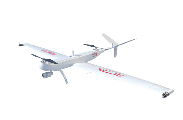
Dragonfish Lite and Pro now available in United States
Photo: Autel Robotics
The rugged Dragonfish UAVs are capable of vertical takeoff and landing (VTOL) with both multi-rotor and winged flight, with an endurance of up to 180 minutes. They are suitable for professional applications such as energy, mining, defense and surveillance. Maximum winged flight speed is 30 m/s (108 km/h, 67 mph), and maximum video transmission range is 30 km (18.6 miles) with a base station. The aircraft can make a smart decision to either land or return to base in case of issues such as loss of GPS signal, loss of operator communications, or low battery power. The tilt-rotor system will automatically transition to multi-rotor mode if adverse conditions cause fixed-winged flight to stall or become unsustainable. The Dragonfish battery, barometer, positioning system, compass and inertial measurement unit all have backup modules to ensure flight safety.
The SureCam connected dash camera system now features a method for capturing video footage from SureCam cameras using Geotab’s telematics device and rule-based system. This results in a seamless display of video within the MyGeotab platform. The enhanced SureCam fleet video solution leverages Geotab’s numerous data-based rules, such as improper seat belt usage and speeding. It also uses G-force triggered alerts that detect unsafe driving behaviors and automatically captures video footage that can be reviewed later. A new Video Request feature in GeoTab enables fleet managers to preview and download additional SureCam video, enabling them to investigate call-ins and other minor incidents that may not have been triggered by an event-based rule.
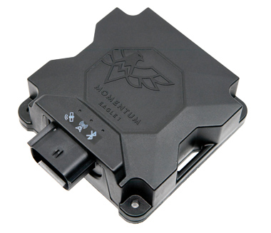
Momentum IoT’s long-life Eagle 1 tracker works without external power for more than six months after a single charge. The device switches on-the-fly between narrowband internet of things (NB-IoT) and LTE Cat-M. The Eagle 1 leverages Telit’s dual-mode ME310G1 module, which delivers low power consumption in a small footprint. The Eagle 1 detects movement with a built-in accelerometer. Using movement and signals from its GPS receiver to determine vehicle trip starts and stops, the device can go into hibernation mode during periods when the vehicle is not in use, further reducing power consumption. Applications include garbage and storage bins, portable toilets, roll-off containers, message-boards, coolers, and other equipment typically stationed in non-powered, remote places for extended periods.
Safran Electronics & Defense is taking a major step forward in its inertial navigation strategy by grouping two subsidiaries, Safran Colibrys (Switzerland) and the recently acquired Sensonor (Norway,) under a single banner, Safran Sensing Technologies.
The similarities in expertise, market position, customers and technologies result in clear synergy between these two companies, which produce accelerometers, gyrometers and inertial measurement units (IMUs). The creation of Safran Sensing Technologies shows Safran’s commitment to developing its micro-sensor business through these two companies.
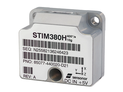
The STIM380H inertial measurement unit. (Photo: Sensonor)
The goal is to jointly offer a wider and comprehensive range of inertial technologies including vibrating sensors, optics and micro-electromechanical system (MEMS) for applications in aeronautics, defense, space and other industries.
The two subsidiaries have already delivered more than 20 million MEMS sensors to the aeronautics, defense, space, transport, mobility and industry sectors. For example, MEMS are used in the control accelerometers of automobile airbags, in high temperature accelerometers for guiding drill heads, and in seismic sensors measuring the structural health of buildings or civil engineering works. They are also used in IMUs for civil, military and space vehicles.
This change is part of a broader Safran Electronics & Defense strategy designed to strengthen the company’s position in the positioning, navigation and timing (PNT) market.
The two entities have been renamed Safran Sensing Technologies Norway AS and Safran Sensing Technologies Switzerland SA, respectively.
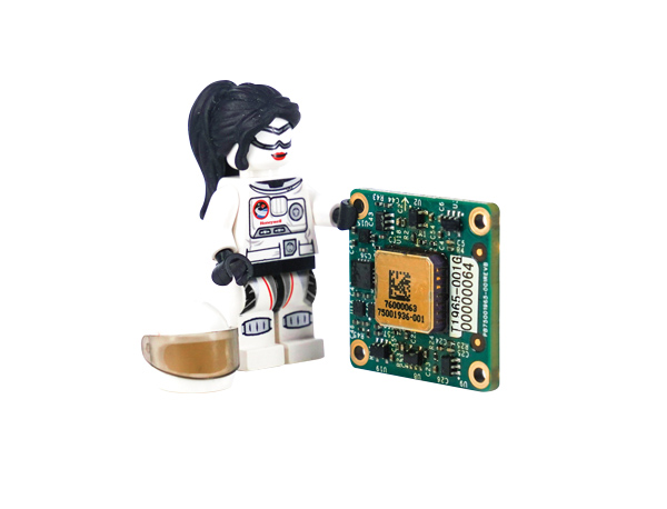
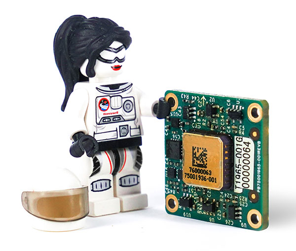
A LEGO Minifigure beside the MV60 shows its small size. (Photo: Honeywell)
Honeywell has unveiled a new accelerometer that delivers high performance and reliability in a small, rugged and low-cost package. The MV60 micro-electromechanical system (MEMS) accelerometer is designed for aerospace and defense, but also has potential uses in industrial and marine applications that require high-precision, navigation-grade accelerometers that are small, lightweight and require little power to operate.
The MV60 measures the acceleration experienced by an object during movement. These types of high-accuracy sensors are mainly used in inertial measurement units and navigation systems deployed on land, air and sea vehicles to measure velocity.
Additionally, inertial systems provide:
key orientation information for drilling operations
precision pointing and altitude determination for vehicles
platform stabilization
target location and surveying.
“The MV60 accelerometer is a technological breakthrough that leverages 50 years of Honeywell inertial sensor and MEMS experience to offer excellent reliability, ruggedness and performance,” said Matt Picchetti, vice president, Navigation and Sensors, Honeywell Aerospace. “Our customers in a wide range of markets will benefit from an accelerometer that is smaller, lighter and requires less power over similar offerings, and they won’t have to sacrifice performance.”
The highly reliable Honeywell MV60 accelerometer features a compact footprint of 1.2 square inches and has shock survivability of up to 5,000 g (g-force). It also offers bandwidth of greater than 300 Hz (hertz) — important for environmentally demanding missions.
The MV60 delivers accuracy and performance that previously had only been available in more expensive solutions. Now, customers have a more affordable, rugged, and small-scale offering suitable for the most demanding navigation applications.
Accelerometers are critical elements of navigation systems, and Honeywell provides a portfolio of precision accelerometers that deliver reliable performance at affordable prices to meet customer needs.
The Mayflower Autonomous Ship (MAS) is set to re-embark on its three-week trans-Atlantic journey in April 2022 equipped with two of Silicon Sensing’s AMU30 inertial measurement units (IMUs). These devices send highly precise motion data to the new ‘AI captain’ that guides the vessel. They also assist in measuring sea surface height as part of detailed scientific analysis of ocean topography.
AMU30 is a micro electro-mechanical system (MEMS) unit with excellent inertial performance, including very good bias stability and low noise characteristics, plus an embedded Kalman Filter-based AHRS (attitude and heading reference system) algorithm. It delivers precise 3-axis outputs of angular rate and acceleration, plus roll, pitch and heading angles, altitude and pressure, and temperature, at 200 Hz — all critical to precise maritime navigation.
“The two AMU30 are used to make real-time, precision measurements of the movement of the Mayflower Autonomous Ship in 6 degrees of freedom (DOF) so that the AI Captain may make minute manoeuvring adjustments to optimise vessel performance in a complex wavefield, while also providing redundant general navigation capability at sea,” said Brett Phaneuf, co-director of the project. “Furthermore, when coupled with optical and RTK (real time kinematics) GPS data, the AMU30 assists the ship in making highly accurate measurements of sea surface height, which are important for studying ocean tides, circulation and the amount of heat the ocean holds.”
The MAS journey across the Atlantic will celebrate the voyage of the original Mayflower some 400 years ago. It is just one element of an extensive scientific data gathering and research programme the vessel will complete in the coming years. The ship is guided by its new AI Captain, built using IBM cloud, artificial intelligence (AI) and edge computing technologies, and uses a hybrid engine that draws on solar power. Working with scientists and other autonomous vessels it provides a flexible platform for deepening understanding of issues such as climate change, ocean plastic pollution and marine mammal conservation. In parallel, the development of marine autonomous systems such as this will transform ocean-related industries such as shipping, oil & gas, telecommunications, security & defence, fishing & aquaculture.
A roundup of recent products in the GNSS and inertial positioning industry from the February 2022 issue of GPS World magazine.
OEM
GNSS Receiver
For tracking, telematics
Photo: u-blox
The LENA-R8 GNSS receiver is based on the u-blox M10 platform. The compact module balances cost and performance with a single antenna and primarily targets customer deployments in the Europe, Middle East, Africa, Asia, and South America regions. Designed for tracking and telematics, the module series was designed to minimize material costs and data charges. The LENA-R8 supports a broad range of frequency bands with 2G fallback, providing maximum roaming coverage for global tracking applications using a single stock keeping unit (SKU).
The low-profile triple-band HC997EXF embedded helical GNSS antenna features eXtended Filtering (XF). It is designed for precise positioning, covering the GPS/QZSS-L1/L2/L5, GLONASS-G1/G2/G3, Galileo-E1/E5a/E5b, BeiDou-B1/B2/B2a, and NavIC-L5 frequency bands. It also covers regional satellite-based augmentation systems (WAAS, EGNOS, MSAS, GAGAN) and L-band correction services. It is packaged in a light (11 g), compact form factor (60 x 25 mm). Its precision-tuned, high-accuracy helical element provides an excellent axial ratio and operates without a ground plane, making it suitable for lightweight unmanned aerial vehicle (UAV) navigation and a wide variety of precision applications.
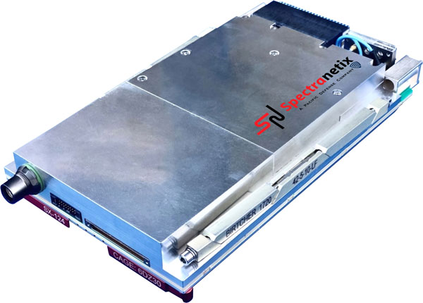
The SX-124 ruggedized 3U OpenVPX high-performance positioning, navigation and timing (PNT) card can provide timing and positioning information in a GPS-denied environment through sensor fusion. It is designed for highly integrated systems with a requirement for the U.S. Army’s C5ISR Modular Open Suite of Standards (CMOSS) and alignment with the Open Group Sensor Open Systems Architecture (SOSA) technical standard. The SX-124 can accept external sources or use its onboard GNSS receivers as reference inputs for timing and positioning data. The positioning data can be fused with internal and external inertial measurement units.
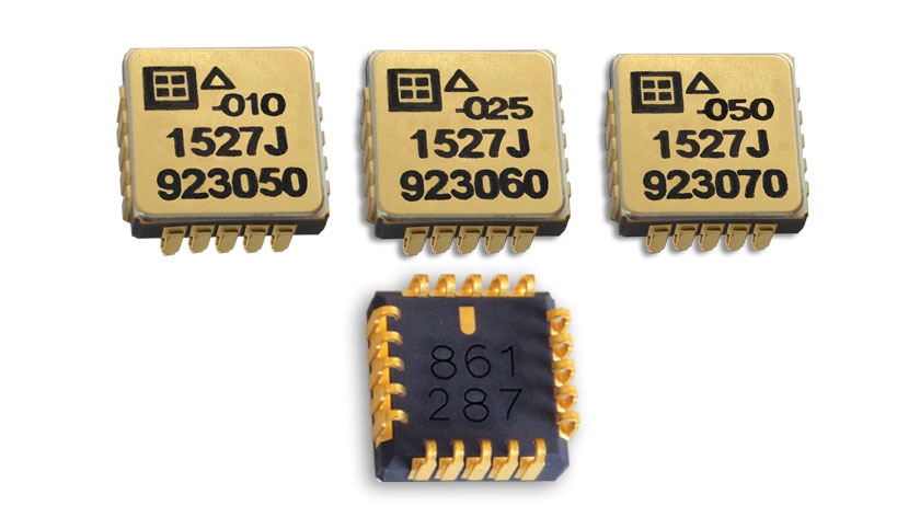
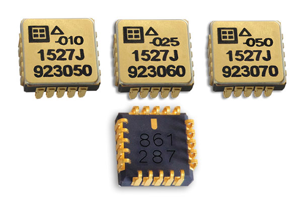
The Model 1527 series is a family of miniature, radiation-tested, tactical-grade micro-electromechanical (MEMS) accelerometers. Offered in three full-scale acceleration ranges — ±10 g, ±25 g and ±50 g — the series is designed to support a variety of critical space electronics testing requirements, including those of spacecraft, satellites and CubeSats. Their small bias and scale-factor temperature coefficients, excellent in-run bias stability and zero cross-coupling make the Model 1527 series particularly well-suited for spacecraft electronics testing applications requiring low power consumption (+5 VDC, 6.5 mA), low noise, long-term measurement stability in –55° C to +125° C environments, and performance reliability under intermittent radiation exposures.
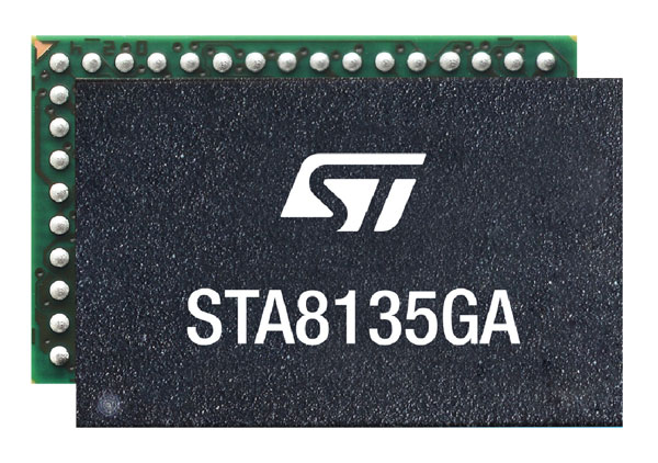
The STA8135GA automotive-qualified GNSS receiver is designed to deliver the high-quality position data needed by advanced driving systems. Part of the Teseo V family, the STA8135GA integrates a triple-band positioning measurement engine. It also provides standard multi-band position-velocity-time (PVT) and dead reckoning. The multi-constellation receiver delivers raw information for the host system to run any precise-positioning algorithm, such as PPP/RTK (precise point positioning/real-time kinematic). The receiver can track satellites in the GPS, GLONASS, BeiDou, Galileo, QZSS and NAVIC/IRNSS constellations.
Survey application 1Edit now has increased support for photos and 2.5D data. 1Edit 3.1 allows users to attach feature photos, including automated geotagging, which enables surveyors to visualize assets and fine tune observations. Also included are new validation functions and improved handling for heights (2.5D data), typically useful for detailed asset and land-management surveys. Enhanced styling, including bitmap fills and dashed lines, make it easier to identify and classify different asset types during surveys. Additional control of editable layers and fields provides protection for non-editable data and protects the data quality. Significant improvements to rendering of thematic mapping enhances the speed and fluidity of the intuitive user interface.
The latest version of Surfer surface mapping software has improved map-making functionality and data exporting capabilities. Surfer is used by more than 100,000 people worldwide, many involved in oil and gas exploration, environmental consulting, mining, engineering and geospatial projects. It provides fast and powerful contouring algorithms, enabling users to model data sets, apply an array of advanced analytics tools, and graphically communicate the results. Frames now have outlines and background fill colors to make them easier to read when placed on top of maps and attribute data can now be exported as numeric data.
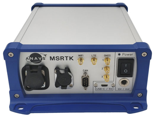
The Multi-Sensor (MS-) RTK/PPP device is a turnkey system easily integrated into surveying applications. The module includes up to three multi-frequency, multi-GNSS (GPS + Galileo + Glonass + BeiDou) receivers, a MEMS IMU, a barometer, a CAN interface for reception of vehicle data (wheel odometry and steering angle), and an LTE module for reception of RTK/PPP corrections. ANavS sensor fusion performs tight coupling of all sensor data with an Extended Kalman Filter (EKF). Various interfaces can connect additional sensors (such as camera or lidar) or output position information.
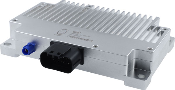
The HD-MapBox integrates high-precision map data based on high-precision positioning. Fusing data from a GNSS receiver, IMU, ADAS camera, vehicle dynamics and HD maps, the HD-MapBox can achieve a lateral error of less than 8 inches (0.2 meters) and a longitudinal error of less than 6.5 feet (2 meters) with a 95% confidence interval, providing an accurate reference for highway pilots and automated valet parking. Even if both GNSS and lane line detection are not available, the HD-MapBox can still enable vehicles to keep inside the lane for at least a quarter mile (400 meters).
Esri ArcGIS IPS is an indoor positioning system that adds a blue dot to indoor maps, enabling users to locate their current position inside a building in the same way GPS enables outdoor location indicators. It uses an alternative technology to enable real-time positioning and navigation inside buildings. It also provides live location sharing and tracking, location data capture and analytical insights. ArcGIS IPS is available for users of ArcGIS Indoors, an indoor mapping system for smart building management, and ArcGIS Runtime SDKs, which enable the indoor positioning capability in custom-built apps.
New radiation-tested, tactical-grade MEMS inertial accelerometers designed for spacecraft electronics testing
Silicon Designs Inc. has launched the Model 1527 series, a family of miniature, radiation-tested, tactical-grade micro-electromechanical (MEMS) inertial accelerometers.
Offered in three full-scale acceleration ranges — ±10 g, ±25 g and ±50 g — the series is designed to support a variety of critical space electronics testing requirements, including those of spacecraft, satellites and CubeSats.
In addition, their small bias and scale-factor temperature coefficients, excellent in-run bias stability, and zero cross-coupling make the Model 1527 series particularly well-suited for spacecraft electronics testing applications requiring low power consumption (+5 VDC, 6.5 mA), low noise, long-term measurement stability in –55° C to +125° C environments, and performance reliability under intermittent radiation exposures.
Radiation test report data, as generated during internal qualification testing, is available on request.
The rugged design of the Model 1527 series combines a tactical-grade MEMS inertial sense element with a custom integrated circuit, internal temperature sensor, onboard sense amplifier and ±4V differential analog output stage. The MEMS inertial sense element and internal components are housed within a lightweight, hermetically sealed, nitrogen-damped, miniature, RoHS compliant, J-lead LCC-20 surface mount ceramic package (U.S. Export Classification ECCN 7A994), weighing 0.68 grams.
Its compact and lightweight footprint allows for ease of accelerometer installation within space-constrained environments, as well as minimization of mass loading effects. Each Model 1527 Series accelerometer is marked with a serial number for traceability on both top and bottom surfaces.
All Silicon Designs’ Model 1527 Series tactical-grade MEMS inertial accelerometers are designed, manufactured, performance-verified and calibrated in-house at the company’s global corporate headquarters and R&D center outside of Seattle, Washington. Product performance documentation is supplied at the time of shipment, including residuals, thermal sensor model, acceleration model, bias, scale factor, linearity, operating current and frequency response data.
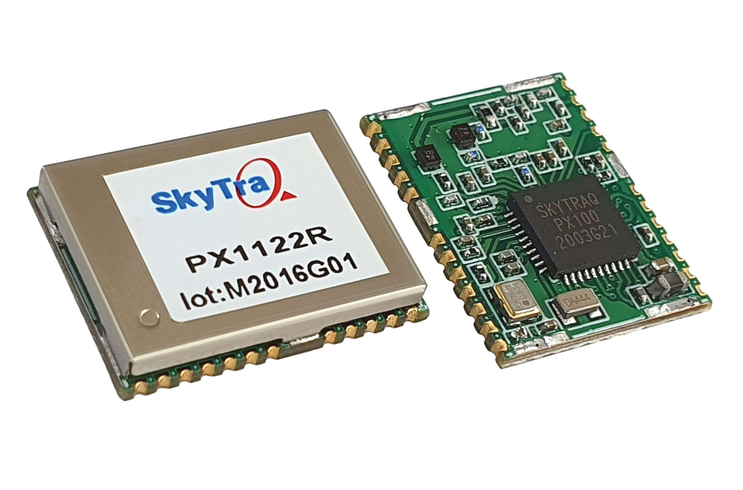
SkyTraq Technology, a fabless semiconductor company, develops GPS/GNSS chipsets and modules for meter-level accuracy vehicle navigation and tracking applications and for centimeter-level accuracy real-time kinematic (RTK) surveying and precision guidance applications.
Photo: SkyTraq
The company’s chipset design is driven by market trends, said Oliver Huang, the company’s general manager. He explained the company has moved from single-frequency to dual-frequency devices.
SkyTraq’s chipset is designed to be common hardware for different target applications enabled by customized software. Traditionally, in the automotive market, vehicle navigation systems have relied on fusing GNSS receivers with dead-reckoning technology that uses micro-electromechanical (MEMS) inertial measurement units (IMUs) and wheel-tick data.
“We are now seeing more aftermarket vehicle tracking applications that take advantage of superior GNSS/DR performance using untethered dead-reckoning technology that uses sensor fusion of GNSS receiver and MEMS IMUs without the need for wheel-tick data,” Huang said. “GNSS receivers with decimeter or better accuracy, combined with dead-reckoning that uses low drift IMUs, will be important in emerging autonomous vehicle applications.”
SkyTraq’s PX100 chipset for L1 meter-level accuracy applications and centimeter-level accuracy RTK applications uses L1 and L1/L2 signals from all four major GNSS constellations (GPS, GLONASS, Galileo and BeiDou).
Because of the trend toward high-precision, which requires good carrier-phase raw measurement data, the biggest challenge in receiver design is with the antenna, Huang explained. “Using an advanced semiconductor process, one can have low power, small size chipsets taking advantage of all the available GNSS signals, yet there is no small antenna capable of producing high-quality carrier phase data for high-precision GNSS applications. So far, we have only seen bulky RTK antennas capable of generating high-precision results.”