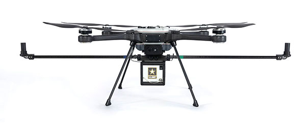
RedTail Lidar Systems has delivered six lidar systems to the 707th Ordnance Company stationed at Joint Base Lewis-McChord. The systems will provide explosive ordnance disposal (EOD) technicians an opportunity to assess how lidar can be used to enhance their operations.
The RedTail Lidar Systems RTL-450 was integrated onto the Teledyne FLIR SkyRaider unmanned aerial system (UAS) to address a broad range of the EOD community’s 3D mapping needs. Captain William R. Hartman, the commander of the 707th EOD Company, stated that the highlight of the testing was using the lidar system to map terrain.
The RTL-450 also can be used to calculate crater volumes from improvised explosive device (IED) blasts, perform route planning for unmanned ground vehicles, aid in mission planning, and conduct surveillance. The 3D point clouds generated allow operating areas to be viewed from any perspective using the rotation and zoom capabilities provided within the viewer software.
The underlying lidar technology used in the RTL-450 was licensed from the Army Research Laboratory (ARL). The micro-electromechanical (MEMS) mirror-based design provides enhanced 3D imagery suitable for applications where artificial intelligence and machine learning (AI/ML) algorithms can be used for target detection and classification, because of the high point density of the point clouds.
The system can operate in either a raster scan mode for surveillance missions or a side-to-side line scan mode for area mapping while the UAS is flying. The intuitive command and control, high brightness display integrated into the ground control station (GCS), and real-time 3D map generation allows operators to begin mission planning and analysis even before the mapping or surveillance missions are completed.
“Delivering these six lidar systems to EOD technicians for test and evaluation is a significant step forward in using MEMS mirror-based lidar technology to address a broad range of Department of Defense 3D mapping needs,” said said Brad DeRoos, president and CEO of RedTail Lidar Systems. In addition, this delivery represents a true success story in transitioning a technology out of a Department of Defense laboratory and back into the hands of military operators.”
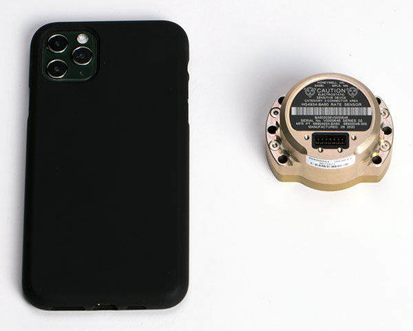
The HG4934 Space Rate Sensor is compared in size to a typical smartphone. (Photo: Honeywell)
New, smaller sensors provide high-performance navigation at a low cost with less power consumption, company said.
Honeywell has unveiled a new rate sensor to help small satellites navigate increasingly crowded orbits above the Earth’s surface. The new micro-electro-mechanical system (MEMS)-based product provides low cost and power consumption in a smaller size than previous Honeywell offerings, while maintaining high performance levels. It is suitable for customers building smaller and lower-cost satellites, according to Honeywell.
Honeywell’s HG4934 space rate sensor is roughly the same size and weight (145 grams) as a baseball. Compared to Honeywell’s previous rate sensors, it consumes only one-fifth the electric power, is more than 32 times lighter, and is 60 times smaller. It also is more tolerant of radiation, a key attribute in space.
“With this new sensor, our customers can build smaller, lower cost satellites that are just as capable and reliable as their traditional predecessors, which will allow them to field new satellite technologies like 5G telecommunications or high-bandwidth global Internet,” said Mike Elias, vice president and general manager, Space, Honeywell Aerospace. “Furthermore, the number of satellites is only increasing, which leads to more crowded orbits. It’s critical that our customers have highly precise navigation solutions to help prevent accidents, which could knock functional satellites out of orbit.”
A space rate sensor, also known as an inertial reference unit or IRU, is an inertial sensor composed of three gyroscopes that work together to sense rotation rates. They determine an aircraft or spacecraft’s change in rotational attitude over time and allow it to move from one location to another without using any external information. It can also serve as a backup solution to provide redundancy if other navigation systems fail.
Celestial navigation options like star trackers are a popular method of obtaining pointing directions for satellites and spacecraft. This form of navigation uses angular measurements between objects in space (stars, planets, etc.) and the horizon to calculate location. However, sometimes these star trackers are blinded by the sun or affected by thruster gases. In this case, Honeywell’s HG4934 can act as a secondary method of attitude determination.
Honeywell’s HG4934 Space Rate Sensor is available now for commercial, defense, and science applications. The first deliveries to customers began at the end of 2020.
The non-ITAR status greatly increases the marketability of the SDI500/SDI505 IMUs to international customers. Plus, Emcore releases new SDI170 IMU and is awarded defense contract.
Emcore’s dual-use SDI500/SDI505 Revision F inertial measurement units (IMUs) have received a determination that they are not subject to the International Traffic in Arms Regulations (ITAR) administered by the U.S. Department of State. Emcore has likewise determined that its SDN500 inertial navigation system (INS) is not subject to ITAR.
The determination of non-ITAR status is expected to dramatically increase the size of the market that Emcore can address with its quartz micro-electro-mechanical systems (QMEMs) IMU and INS devices.
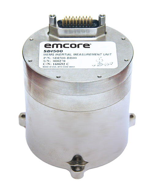
Photo: Emcore
Ranked Top in Trade Study. The SDI500/505 IMU was ranked first in overall accuracy, reported Emcore, in a U.S. military-commissioned trade study of 19 IMUs being evaluated as an alternative to the Honeywell HG1700 for various weapons systems.
The objective of the third-party independent study was to deliver a comprehensive report to the government and make a recommendation supported by clear and compelling technical, financial, and other relevant data collected regarding the most advantageous IMU products and services available in the market today. 19 IMUs of various technologies, complexity, cost, and developmental status, from leading manufacturers, were evaluated in short and long flyout simulations against the HG1700.
The dual-use non-ITAR SDI500/505 IMUs are designed to achieve the demanding performance levels required in sophisticated systems, including weapons guidance and targeting, commercial and defense fixed-wing aircraft and helicopters, unmanned autonomous vehicles (UAVs), and a wide variety of other high-precision commercial, industrial, marine, defense and space applications. They leverage quartz MEMS technology to deliver angle random walk (ARW) values of 0.02°/√hr with 1°/hr bias stability.
Defense Contract Award. In March, Emcore was awarded a development contract valued at $1.1 million by a major U.S. prime contractor to design and manufacture a high-end IMU for tactical intelligence and reconnaissance systems. The prototype phase has been successfully completed and as part of the contract in this follow-on phase, Emcore will deliver initial production units that will be used for proof of manufacturing and system level qualification.
The custom IMU will be based on Emcore’s proprietary closed-loop fiber-optic gyro (FOG) technology that delivers proven CSWaP (cost, size, weight and power) and performance advantages over other FOGs and competing technologies. It is designed to deliver the highest level of performance in Emcore’s tactical IMU product line, exceeding Emcore’s EN-300. Emcore’s FOG IMU technology delivers ten times the bias performance of legacy systems in compact form-, fit- and function-compatible packages.
New SDI170 IMU. Emcore also launched a replacement IMU. The new SDI170 quartz MEMS tactical-grade IMU is designed as a form-, fit- and function-compatible replacement for the HG1700-AG58 ring-laser gyroscope (RLG) IMU, but with superior overall performance, versatility and a significantly higher mean time between failures (MTBF) rating over ruggedized environments.
The SDI170 IMU is suitable for continuous-use applications with no wear-out components and delivers highly linear accelerometer performance and longer life compared to the HG1700 IMU. It is not ITAR controlled and has completed extensive internal and external customer testing to confirm compatibility to replace legacy products.
The unit is designed for a wide range of high-precision, integrated commercial and defense applications including aircraft Attitude Heading Reference Systems (AHRS), GPS-aided navigation, ground surveying, mobile mapping, ROVs, autonomous vehicles, tactical weapons, and stabilization platforms.
Non-ITAR Determination. As a result of this Commodity Jurisdiction (CJ) determination concluded by the U.S. Department of State, EMCORE’s SDI500/SDI505 Revision F commercial off-the-shelf (COTS) offerings were confirmed to be subject to the Export Administration Regulations (EAR) administered by the Department of Commerce (DOC). EAR classification typically results in fewer export-related restrictions and requirements. For this reason, this CJ determination for the SDI500/SDI505 will greatly increase the marketability of these IMUs to international customers.
The SDN500 is Emcore’s most advanced QMEMS INS/GPS tactical-grade system, combining the latest generation quartz gyros and accelerometers from the SDI500/SDI505, with high-speed signal processing and a 48-channel coarse/acquisition code GPS receiver into a powerful, tightly coupled guidance and navigation system.
“We would like to thank the U.S. Department of State for its evaluation of our commodity jurisdiction request and conclusion that our dual-use SDI500/SDI505 IMUs are not subject to ITAR,” said David Hoyh, Emcore’s director of sales and marketing for navigation products. “The determination of EAR status under the DOC enables more customers worldwide to benefit from these important, high-precision Emcore products.”
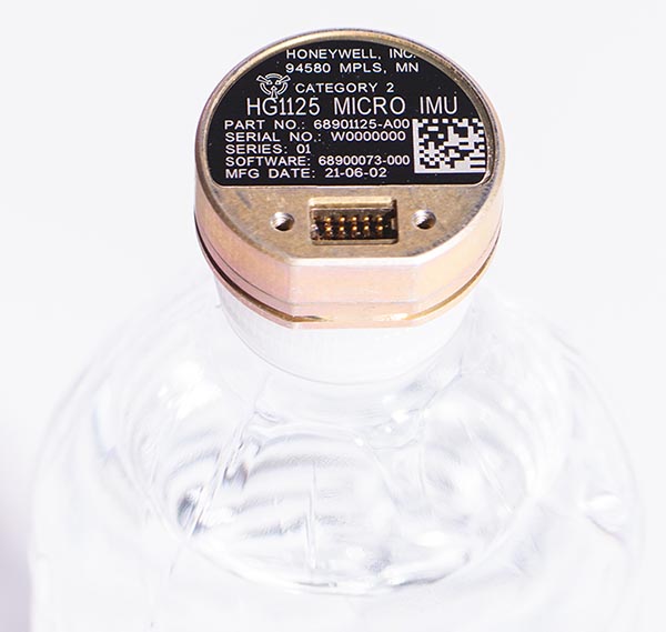
As illustrated here, the new HG1125 IMU is about the size of a water-bottle cap. (Photo: Honeywell)
Honeywell has launched a new series of miniature inertial measurement units (IMUs) ruggedized to offer high accuracy along with the durability to survive high-shock environments.
Roughly the size of a water-bottle cap, the new HG1125 and HG1126 IMUs are low cost and serve both commercial and military applications.
The new family of IMUs can survive shocks up to 40,000 G-force, making it one of Honeywell’s toughest IMU products to date. The HG1125 and HG1126 can be used for a variety of defense and commercial applications such as tactical military needs, drilling, unmanned aerial vehicles or navigation systems for general aviation aircraft.
“Low-cost, ultra-rugged IMUs are in high demand across a variety of market segments where customers need high-performance navigation, but they’re limited by size or cost constraints,” said Matt Picchetti, vice president and general manager, Navigation & Sensors, Honeywell Aerospace. “Our new HG1125 and HG1126 products meet all of these requirements, making them an ideal solution for customers operating in a wide variety of high-shock environments, including everything from military tactical operations to industrial applications such as drilling.”
An IMU uses gyroscopes, accelerometers and electronics to give precise rotation and acceleration data. This enables a vehicle system to calculate where it is, in what direction it is going, and at what speed, even when GPS signals are not available.
The HG1125 and HG1126 use sensors based on micro-electromechanical systems (MEMS) technology to precisely measure motion. They are the newest IMUs from Honeywell’s tactical IMU production facility, which delivers nearly 100,000 IMUs each year to customers across a wide range of segments.
The first deliveries of these new products are set to begin in June.
Honeywell’s lineage in navigation dates to the 1920s, and it has long been a pioneer in MEMS-based IMUs. Honeywell has developed and manufactured high-performance navigation solutions found on many aircraft and other vehicles worldwide.
Agreement focuses on increasing development and capacity for ultra-compact, low-power laser-beam scanners to expand the market
STMicroelectronics and OQmented, a startup focused on MEMS-mirror technology, have agreed to collaborate on the advancement of the technology for augmented reality and 3D-sensing markets. Micro-electro-mechanical systems (MEMS) combine tiny 3D mechanical structures and electrical circuits on a chip to sense and actuate activity.
The joint effort aims to build on the expertise of both companies to advance the technology and products behind the leading MEMS-mirror-based laser-beam scanning solutions in the market.
ST manufactures MEMS sensors, actuators and related components including drivers, controllers and laser-diode drivers. ST is contributing its MEMS design and manufacturing resources to the collaboration.
OQmented plans to further industrialize and mass produce its Bubble MEMS technology, a patented 3D glass-encapsulation method of hermetic vacuum sealing of MEMS micro-mirrors. The glass bubbles eliminate environmental contaminants and minimize light-refraction effects.
Automotive grade. Vacuum sealing is a key element for meeting automotive-grade requirements, while simultaneously reducing power consumption by an order of magnitude and enhancing performance for resonant, bi-axial scanners, where the MEMS mirrors move in both axes at their resonant frequency, creating an ultra-compact and power-efficient scanning solution. The resonant mirrors are suitable for display and 3D sensing applications in mobile devices.
“In teaming with ST, we’ve chosen a solid semiconductor partner that has demonstrated its leading position in design and manufacturing of MEMS products, particularly MEMS mirrors, over the past 20 years,” said Ulrich Hofmann, CEO/CTO and co-founder, OQmented. “Combining ST’s expertise in developing, marketing, and manufacturing key components for laser-beam scanning solutions with OQmented’s knowledge and intellectual property will contribute greatly to our product offering, manufacturing capacity, and marketing channels, while also expanding the market in numerous application areas.”
“Our goal in working with OQmented is to leverage our shared expertise and deep understanding of laser-beam scanning technologies with the mutual vision to continue the adoption and growth of laser-beam scanning in key applications, such as augmented reality and 3D sensing,” said Anton Hofmeister, vice president and general manager, MEMS Microactuator Division, STMicroelectronics.
From the joint effort, ST and OQmented plan to market a wide range of scanning solutions. These would include MEMS mirrors, MEMS drivers and controllers, and complete reference designs of laser-beam scanning engines for a range of applications. The companies also intend to collaborate on a laser-beam scanning roadmap and the development of future technologies and products.
Murata has developed a new (micro-electro-mechanical systems (MEMS) six-degrees-of-freedom (6DoF) inertial sensor for GNSS positioning support, autonomous off-highway vehicles and dynamic inclination sensing. Murata’s new SCHA63T sensor is a single package 6DoF component. It can enable centimeter-level accuracy in machine dynamics and position sensing, and can assist in ensuring safe, robust and verified designs.
The sensor enables further advancement in technology and novel solutions for GNSS-based measurement instruments, advanced driver/operator assistance systems, and autonomous vehicles.
The product delivers highest performance available on the component level in the key parameters of bias stability and noise. Murata calibrates orthogonality of all measurement axes, which allows customers and system integrators to skip that critical process step.
A key focus area in product development for SCHA63T has been to ensure operation during high mechanical shock and vibration. Within the same product family, sensor variants are qualified according to the automotive AEC-Q100 standard. The SHCA63T sensor includes advanced self-diagnostic features and can achieve full compliance with ASIL-D (Automotive Safety Integrity Level-D).
The SCHA63T sensor features extensive failsafe functions and error bits for diagnostics. These include internal reference signal monitoring, checksum techniques for verifying communication, and signal saturation/over range detection.
The diagnostic feature of Murata’s three-axis accelerometer is the continuously operating self-test function, which monitors the sensor during measurement. This patented self-test function verifies the proper operation of the entire signal chain, from MEMS sensor element movement to signal conditioning circuitry for every measurement cycle. Even if the system using SCHA63T is not required to follow international functional safety standards, the provided design support documentation enables for customers a cost effective, robust and fast design process.
Murata, based in Japan, has more than 20 years of experience of providing inertial sensors for safety-critical automotive applications like electronic stability control.
With a very good PNT device already installed for flying the aircraft, why not just tap into that one for the payload, right? This might not be a good idea, for several reasons.
By John Fischer Vice president, Advanced R&D, Orolia
John Fischer. (Photo: Orolia)
The navigation device in a UAV is very important, precisely because there is no pilot. It must navigate autonomously. It must also be optimally suited for the airframe, either fixed or rotary wing, providing the accuracy and reliability for all modes of flight, from takeoff to landing. A lot of engineering goes into the design and certification of each UAV’s navigation system to qualify it for flight.
UAVs can have multiple missions with interchangeable payloads: cameras for observation and inspection; communication equipment for relaying links or supplying emergency cellular base stations; or sensing equipment such as radar, lidar, spectrometers, etc. These payloads also need positioning, navigation and timing (PNT) sources for their missions, for example, to accurately geo-timestamp the collected data.
With a very good PNT device already installed for flying the aircraft, why not just tap into that one for the payload, right? Actually, this might not be a good idea, for several reasons.
Recertification. Modifying the navigation device, which is part of the flight control system, risks having to re-certify the aircraft for flight safety. Though a UAV has less severe restrictions on safety than a manned aircraft, it can still cause property damage or even injury and loss of life if it crashes in a populated area. The Federal Aviation Administration has numerous standards — DO-178 for software, DO-254 for hardware, DO-160 for testing — to ensure avionics are designed and tested for safe operation. Every modification, regardless of how small, must follow these standards and may require expensive re-certification of the aircraft’s airworthiness.
Performance Requirements. These vary with each mission. The flight control system includes a navigation device that was selected based on the aircraft’s special requirements. These will not necessarily match the needs of the payload. For example, consider pitch, roll, and yaw sensing accuracy. The accuracy required to determine the pointing angle of a camera might not be the same as what is needed for level flight.
Interchangeability. A particular UAV can have multiple payloads for different missions. Conversely, a particular mission payload can be adapted and installed on several different UAVs. Having a second PNT device matched to the payload allows it to stay with the payload as it is moved to different UAVs. This can lower the total cost of ownership and operation, since the extra cost of a second device is small compared to the adaption work and design changes necessary to make a single PNT device be suitable for all situations.
Missing the T in PNT. Typically, the navigation device for flying the aircraft doesn’t have a precise internal oscillator for supplying time and/or frequency — it doesn’t need it. However, most payloads can benefit from the time/frequency component to enhance mission performance. A low phase noise oscillator with low g-sensitivity that is disciplined by the precise time supplied by a GNSS receiver can substantially improve the performance of any payload radar or communication system.
A second device does not impact SWAP or cost significantly — GNSS receivers and inertial navigation systems are no longer large, expensive items. A second PNT device is typically small, weighing less than a kilogram and consuming only a few watts of power. There are also fewer connectors and cable harnesses when a removable payload is not sharing the aircraft’s PNT data, so the weight differential might be zero. PNT devices can share antennas on the aircraft via splitters, so there is no need to place additional antennas.
Technology upgrades. Micro-electromechanical systems (MEMS), inertial sensors, cameras, lidars, radars and other sensors are all evolving at a rapid pace with better technology available with each passing year. Flight control systems evolve at a different pace — mostly because of the flight certification process, but also for lack of a driving need. UAVs navigate just fine with the equipment they have today. A separate payload PNT device allows the system designer to keep pace with evolving technology, choosing the latest and best for the mission without disrupting the navigation system.
Just as “two heads are better than one” for problem solving, having two PNT devices in a UAV is often the better solution.
John Fischer is vice president, Advanced R&D, Orolia, and a member of GPS World’s Editorial Advisory Board.
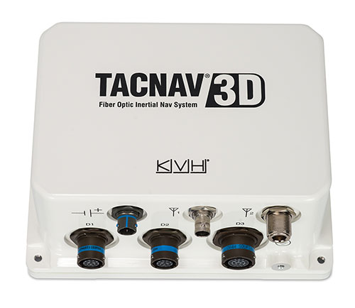
KVH has been developing and testing the PIC technology for more than three years and is continuing to roll the technology into existing product lines.
KVH’s PIC technology features an integrated planar optical chip that replaces individual fiber optic components to simplify production while maintaining or improving accuracy and performance. KVH’s IMUs with PIC technology are designed to deliver improved bias stability and 20 times higher accuracy than other micro-electromechanical systems (MEMS) IMUs.
The fiber-optic gyro (FOG)-based TACNAV 3D tactical navigation system provides an assured positioning, navigation and timing (A-PNT) solution with an embedded GNSS and optional chip-scale atomic clock (CSAC). TACNAV 3D’s modular tactical design enables it to function as a standalone inertial navigation solution and as the core of an A-PNT-capable multi-functional battlefield management system.
“We are pleased to incorporate our newest technology into the TACNAV 3D,” said Dan Conway, executive vice president of KVH’s inertial navigation group. “We are committed to ensuring that this battle-proven system provides the precise navigation that is vital to mission success and addresses the military demand for assured positioning, navigation, and timing (A-PNT) solutions.”
KVH’s TACNAV solutions are being used in vehicles that operate in demanding environments, from battle tanks and M-ATVs, to armored vehicles, reconnaissance and combat support vehicles.
Defense forces using TACNAV systems include the U.S. Army and Marine Corps, as well as many allied customers including Australia, Botswana, Brazil, Canada, Egypt, France, Germany, Great Britain, Italy, Malaysia, New Zealand, Poland, Romania, Saudi Arabia, Singapore, South Korea, Spain, Sweden, Switzerland, Taiwan and Turkey.
Findings show accuracy of new sensors is improved by greater than an order of magnitude over current offerings.
Honeywell, with funding from the U.S. Defense Advanced Research Projects Agency (DARPA), is creating the next generation of inertial sensor technology that will one day be used in both commercial and defense navigation applications.
The HG1930 IMU. (Photo: Honeywell)
Findings gathered in Honeywell labs have shown the new sensors to be greater than an order of magnitude more accurate than Honeywell’s HG1930 inertial measurement unit (IMU) product, a tactical-grade product with more than 150,000 units currently in use.
An IMU uses gyroscopes, accelerometers and electronics to give precise rotation and acceleration data to enable a vehicle system to calculate where it is, what direction it is going and at what speed, even when GPS signals aren’t available.
There are various types of IMUs on the market, and some — like the next-generation version currently under development — use sensors based on micro-electromechanical systems (MEMS) technology to precisely measure motion.
“Typically, MEMS inertial sensors have been on the lower end of the performance scale, but this latest milestone shows we are changing that paradigm,” said Jenni Strabley, director of offering management for Inertial Sensors, Honeywell Aerospace. “With this next-generation MEMS technology, we’re increasing performance without having to significantly change the size or weight of the IMU. This is a game-changer for the navigation industry, where customers need highly accurate solutions but cannot afford to compromise on weight or size.”
Over the past few years, Honeywell has been working with DARPA to develop the next generation of high-precision navigation-grade IMU technology, under the Precise Robust Inertial Guidance for Munitions: Thermally Stabilized Inertial Guidance for Munitions program.
The new MEMS sensors will use different sensor designs and electronics to enable higher performance. They will serve a broad range of applications in autonomous land and air vehicles for both military and commercial customers, including future urban air mobility aircraft.
“Now that we have demonstrated that MEMS is capable of reaching these incredibly precise performance levels, it is the perfect time to start talking with potential users about how this technology could help their applications,” Strabley said. “We believe this new technology will have a variety of applications, such as onboard future vehicles that will fly in urban environments where lightweight, extremely precise navigation is critical to safer operations. Additionally, there are other applications that haven’t been invented yet but may be enabled by these types of technology innovations.”
Commercial sales of an IMU containing these next-generation sensors are still several years away, but one of the first products using this new technology is expected to be more than 50 times more accurate while roughly the same size as Honeywell’s IMU.
Honeywell has long been a pioneer in MEMS-based IMUs, including the HG1930. Honeywell’s lineage in navigation dates to the 1920s and since then Honeywell has developed and manufactured high-performance navigation solutions found on many aircraft and other vehicles worldwide.
Inertial Labs is offering a new industrial-grade inertial measurement unit (IMU) for aerospace and defense applications, among others.
The Kernel-100 is a compact, self-contained strapdown IMU that measures linear acceleration and angular rates with three-axis MEMS accelerometers and three-axis MEMS gyroscopes.
The Kernel-100 is fully calibrated, temperature compensated, mathematically aligned to an orthogonal coordinate system. It contains up to 2 deg/hr bias in-run stability gyroscopes and 10 μg bias in-run stability accelerometers with extremely low noise and high repeatability.
The Kernel-100 is a fully integrated inertial solution that includes the newest MEMS sensor technologies. With seamless integration, the Kernel-100 inertial system is a cost-effective high performance yet compact and low-power IMU, the company said. The Kernel-100 is easy to integrate in a wide range of higher order systems while consuming very little space and power.
With continuous built-in test (BIT), configurable communications protocols, electromagnetic interference protection, and flexible input power requirements, the Kernel-100 is built to be used in a wide variety of environments and integrated system applications.
Built for air, marine and land environments, the Kernel-100 can be integrated into motion reference units, attitude and heading reference systems, and GPS-aided inertial navigation systems. As a result, the Kernel-100 is suitable for a wide variety of applications such as autonomous vehicles, antenna and line-of-sight stabilizations systems, and buoy or boat motion monitoring.
Inertial Labs provides innovative solutions to commerce, industry and government for defense and aerospace.
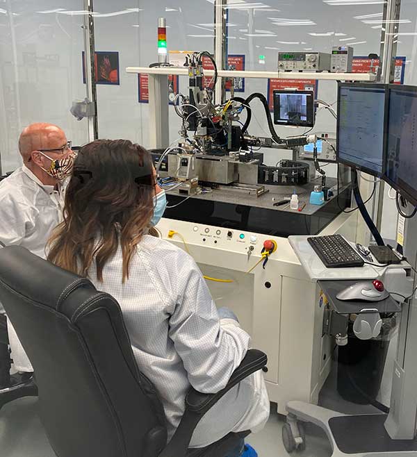
KVH photonics engineers test PICs for validation prior to production. (Photo: KVH)
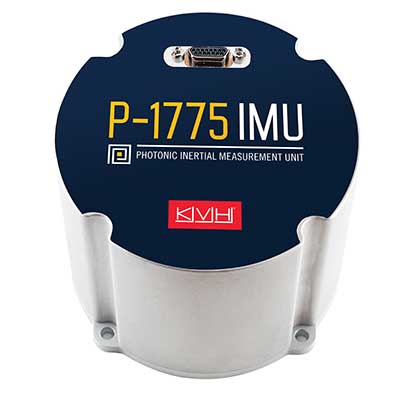
In June, KVH Industries launched the P-1775 inertial measurement unit (IMU), featuring its new PIC Inside photonic integrated chip (PIC) technology.
After developing and testing the technology for more than three years, the company began incorporating it into existing product lines and has shipped the first units.
The PIC technology features an integrated planar optical chip that replaces individual fiber-optic components to simplify production while maintaining or improving accuracy and performance.
The product is designed to deliver 20 times higher accuracy than less expensive micro-electromechanical systems (MEMS) IMUs. It uses modular designs for ease of integration and has outstanding repeatability unit-to-unit, according to the company.
KVH will add the technology to its inertial sensor product line for use across a broad range of applications, from navigation to stabilization and pointing.
KVH’s fiber-optic gyros (FOGs) and FOG-based products are particularly well-suited for the large and growing autonomous market, which includes applications on land, sea and air, such as drones, people movers, trucks and mining and construction equipment.
Moving Components to the Chip
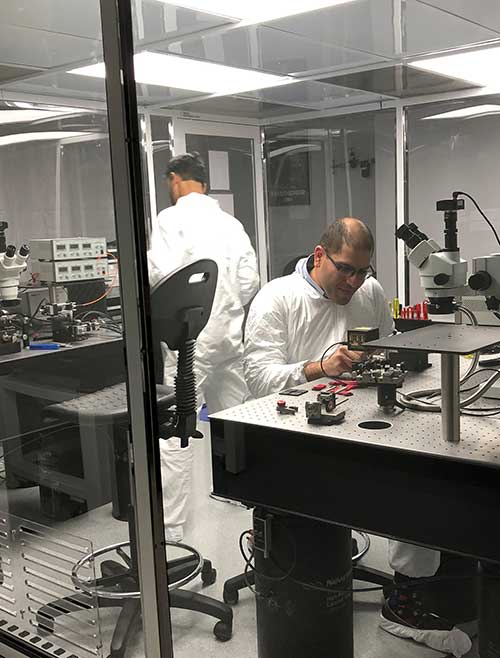
Photo:With PIC technology, KVH’s FOG production process incorporates machine automation for photonics assembly. (Photo: KVH)
The controls on FOGs have an electronics portion and an optics portion. The latter consists of a light source, a detector, couplers, polarizers, a coil (which performs the sensing), and a piezoelectric device for modulating the light, explained Robert Balog, KVH’s chief technology officer.
Until now, the company had fabricated all the products for that optical circuit in its Chicago facility, in a process that was labor-intensive and required much process control. For the PIC, “We’ve taken the couplers and the polarizer sections specifically and moved them onto the chip level,” Balog said.
While KVH manufactures the chip much like any other semiconductor device, rather than passing the light through the fiber KVH is now passing it through wave guides that are contained within that photonics chip, thereby moving the creation of the coupler module into a wafer-level component.
Mass Production and Better Quality
KVH produces the chips en masse on a wafer, then singulates and samples them. Once they are qualified and spot-checked, the chips are incorporated into KVH products.
“This affords us a way to mass produce those components,” Balog said, “and gives us much better quality.”
Photo: KVH
Additionally, it produces a much smaller device than before. The company will not reveal any numbers regarding its performance improvement until it produces and distributes more PICs, but “it is already producing better results than the manually produced components.”
The production process is intimately linked to the overall performance of the sensor. “The tighter your process control, the more reliable you can make the product,” Balog said.
The new process also improves the device’s field reliability because it contains fewer discreet components. The improved performance specifications on each individual FOG improve the overall performance of the IMU or the inertial navigation system (INS) because the bias is more stable and repeatable.
The Future
What is in the technology’s future?
“The next step is integrating the light source and the detector and potentially a modulator into that chip as well,” Balog said. “So, our ultimate technology road map is to continue condensing what would have been discrete components in traditional gyros all within that chip. As this technology progresses, it will get smaller, tighter, and better. Then you will see big leaps in performance.”
New patented PIC Inside technology is designed to enhance inertial sensor performance and reliability for the growing autonomous market
Photo: KVH
KVH Industries has launched the P-1775 inertial measurement unit (IMU), featuring KVH’s new PIC Inside photonic integrated chip (PIC) technology.
KVH has been developing and testing the technology for more than three years and is now incorporating it into existing product lines. The first units have started shipping.
One of the first customers has integrated the P-1775 IMU into its next-generation rocket launch vehicle.
KVH’s PIC Inside technology features an integrated planar optical chip that replaces individual fiber-optic components to simplify production while maintaining or improving accuracy and performance.
The PIC Inside product is designed to deliver 20 times higher accuracy than less expensive MEMS inertial measurement units, uses modular designs for ease of integration, and has outstanding repeatability unit-to-unit.
“I applaud the tremendous effort by our incredible engineers in developing this groundbreaking technology and I am thrilled that we have begun to incorporate PIC Inside technology into our existing products, a process that we expect to continue throughout the year,” said Martin Kits van Heyningen, KVH CEO.
The PIC technology will be added to KVH’s inertial sensor product line for use across a broad range of applications from navigation to stabilization and pointing. KVH’s fiber-optic gyros (FOGs) and FOG-based products are particularly well-suited for the large and growing autonomous market. This market includes applications on land, sea and air, such as drones, people movers, trucks, and mining and construction equipment.
Autonomous applications rely on high-quality inertial sensors to deliver an extremely accurate navigation solution, delivering the performance required in critical metrics such as angle random walk (ARW) and bias instability.
Next-generation driverless cars, which require centimeter-level precision for safety, are the ideal application for KVH’s inertial products, KVH said. Employing the PIC design allows for a lower cost and scalable solution due to the elimination of various fiber components and a reduction of labor.
In 2019, KVH delivered its first product prototypes containing PIC technology to automotive customers and presented the science behind the technology to an audience of engineers at an inertial sensor conference, describing the extensive development, testing, and benefits of the new technology.
KVH is a leading innovator for assured navigation and autonomous accuracy using high-performance sensors and integrated inertial systems. KVH’s widely fielded TACNAV systems are in use by the U.S. Army and Marine Corps as well as many allied militaries around the world. KVH’s FOGs and FOG-based IMUs are in use today in a wide variety of applications ranging from optical, antenna and sensor stabilization systems to mobile mapping solutions and autonomous platforms and cars.