Tag: mobile mapping

  • Hexagon | NovAtel: Creating a digital world

    Hexagon | NovAtel: Creating a digital world

    Photo: Hexagon | NovAtel
    Hexagon | NovAtel’s CPT7 integrates a GNSS receiver and an INS to deliver up to centimeter-level accuracy. (Photo: Hexagon | NovAtel)

    We discussed mobile mapping with Bryan Leedham, product manager of enclosures and post-processing software, NovAtel, Autonomy & Positioning division, Hexagon.


    How do you define mobile mapping?

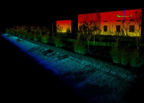
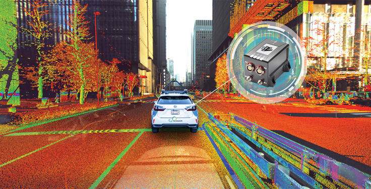
    It is getting broader in scope, as more folks find reasons to map the world. The key goal is to capture reality from mobile platforms to build a digital representation of reality for some large area, such as a city, a road or a factory. Most of the time, that means from a ground vehicle on public roads.

    It’s also safer and faster than traditional surveying because you don’t have to stop traffic or dodge it.

    Right! In an ideal world, rather than spending days setting up traditional survey equipment, you could strap some sensors on a mobile platform and gather accurate map data in minutes.

    What are the key remaining technical challenges?

    Picture one of Google’s or Waymo’s mapping vehicles. The first sensors that come to mind are GNSS, inertial, lidar and radar. Each of those has its own unique strengths and weaknesses. The first technical challenge that remains is to mature each of those technologies for a lower enough cost that it’s affordable.

    Right now, mobile-mapping vehicles are quite expensive, especially in areas where some of these sensors will struggle more than others. To map very dense urban spaces — with underground areas, overpasses and tall buildings where GPS is challenged — you need a very strong localization system that can survive those conditions for however long it takes to drive through them. If I’m building a car to map rural Alberta, I could choose much cheaper sensors than if I were trying to map downtown Chicago every week.

    On the flip side, you must deal with the massive amounts of data collected.

    Yes, that is a very large challenge. Lidar data, in particular, is guilty of generating very large point clouds. It’s a balancing act. More accurate and higher resolution maps require lidar sensors with even denser point clouds. So, you need data management and sufficient processing power to get accurate results quickly.

    What are the key technical challenges in sensor fusion?

    Sensor fusion is how we approach the goal of mapping as accurately as possible in increasingly difficult environments. On their own, GNSS receivers struggle in obstructed areas but, when you pair them with other sensors, they become very complementary.

    Lidar and cameras, for example, are quite good at measuring the distance to nearby objects and at classifying them, but they have no idea where they are relative to one another. Likewise, if you let an IMU [inertial measurement unit] sit in your car, it will no longer know its location. However, once you give it a position update, it is very good at maintaining a trajectory over a short period of time. When you combine absolute and relative localization, all the sensors play to their own strengths.

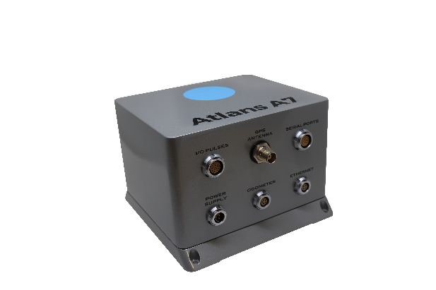
    What is NovAtel’s SPAN software?

    It stands for synchronous position, attitude and navigation. It is the sensor-fusion software that combines the GNSS, inertial and whatever other sensors. It is based on core NovAtel GNSS receiver software. We can use NovAtel receivers in combination with IMUs from a wide range of manufacturers and, in the future, hopefully, other sensors from a variety of manufacturers as well.

    SPAN started with blending just GNSS and inertial but we’re now researching how to bring in such things as lidar and cameras. Autonomous Stuff, another Hexagon company, works on the greater sensor fusion using SPAN as well.

  • Ticket presale open for INTERGEO 2022

    Ticket presale open for INTERGEO 2022

    Photo: INTERGEO

    The INTERGEO Expo & Conference focuses on innovations for a smarter world. INTERGEO 2022 will take place October 18-20 in Essen, Germany.

    Topics including the importance of geoinformation for internal security, monitoring for disaster control and prevention, open data, digital twins alongside their use in construction and housing, mobility, sustainability and climate change, BIM and engineering applications with UAV, laser scanning and monitoring will be discussed during the 2022 event.

    Additionally, the outdoor area of Messe Essen will show live demonstrations of the latest UAV applications in surveying, agriculture, construction, security and many more.

    According to INTERGEO organizers, 300 international companies are already registered at the Expo, from innovative young start-ups to international key players such as Autodesk, Esri Inc., Hexagon, Trimble, Topcon and many more. The organizers expect around 500 exhibitors by October.

    “All the international key players in the industry will be there.There was no doubt about it – they all want to get back to their customers, to visitors, to the live atmosphere and the power of meetings”, says Prof. Dr-Ing. Hansjörg Kutterer, President of the organiser DVW e.V., Association for Geodesy, Geoinformation and Land Management.

    For those who are unable to attend the event in Germany, there will be some opportunities to participate in the Expo remotely.

    Up close and personal

    Digital Twins will receive their big break at the Conference 2022. Their use in building information modeling, smart planning and construction as well as mobility will be the focus of the event. Digital twins will be used to further development of urban data platforms in the context of smart cities and their variety of applications, as well as the use of smart city solutions in terms of innovation and sustainability and a basis for predictions and scenarios in the event of disasters.

    The main topics in 2022 are Digital Twins and their value creation, 4D geodata and Geospatial IoT, potentials of remote sensing, BIM 4.0, industrial surveying, measurement systems and robotics, smart cities and mobility in the context of climate change and sustainability, mobile mapping, web services and GeoIT in disaster relief, spatial reference and positioning, earth observation and Galileo.

    Hansjörg Kutterer points out the high innovative power of the industry: “We are experiencing high dynamics in segments such as mobility, environment and sustainability, climate protection and urbanization. Geo-IT has positioned itself as a solution provider for these topics. Problem-solving without Geo-IT is unthinkable in these subject areas. Come to Essen on the 18th to 20th of October and visit Intergeo Expo and Conference.”

    How to attend

    Tickets for INTERGEO are now available. An early-bird registration rate is available until August 31. Tickets can be found at https://www.intergeo.de/en/tickets.

    Registration for new exhibitors is open as well. All information, such as application procedures and funding amounts, can be found on the INTERGEO website at www.intergeo.de/en/.

  • Leica Pegasus TRK mobile mapper guided by AI

    Leica Pegasus TRK mobile mapper guided by AI

    Photo: Leica
    Photo: Leica

    Leica Geosystems, part of Hexagon, has introduced Leica Pegasus TRK, a reality-capture mobile-mapping system that features artificial intelligence (AI), autonomous workflows and intuitive interfaces.

    The Pegasus TRK features an AI-enhanced camera and automatic camera calibration. To comply with privacy regulations, its AI can identify and blur identifiers, such as people and vehicles, in real time.

    Features include advanced dynamic laser scanning and an expandable imagery system for recording, measuring and visualizing environments. It also increases productivity with automated, intelligent workflows.

    Light enough to be operated by one person, the Pegasus TRK is user-friendly, able to be used by professionals new to the technology. Its reliable, high-quality deliverables serve the needs of technical experts in various industries, including surveying, transportation and utilities.

    The Pegasus TRK solution enables long-range mobile mapping for applications in asset management; road construction; rail and critical infrastructure; oil, gas and electricity industries and more. The system also is suitable for creating high-definition base maps for autonomous vehicles.

    The Pegasus TRK connects with the new powerful Leica Pegasus FIELD software for fully autonomous and secure data collection and route planning in the field. It also connects with Leica Cyclone Pegasus OFFICE for seamless input into post-processing and publishing workflows.

    “The Pegasus TRK solution is the most efficient mobile mapping product we’ve tried so far,” said Raymon Somford, CEO and owner of Rise3D. “It is lightweight and easy to use, guiding our team through the process of data collection. Its sensors that trigger automatically avoid missing details. We can achieve quality images regardless of the conditions, making mobile mapping almost effortless.”

    “The Pegasus TRK solution offers flexibility, true-to-life image clarity and best-in-class accuracy while making mobile mapping more accessible and easier than ever before,” said Christian Schäfer, business director, Mobile Mapping at Leica Geosystems. “There is a growing demand for more autonomy. This solution raises the bar in data collection with automated route planning, guidance and collection processes that increase efficiency, improve data quality and reduce project costs.”

    The Pegasus TRK will be a featured Tech Highlight at Hexagon’s flagship digital-reality solutions conference HxGN Live Global in Las Vegas, which takes place June 20-23.

  • OxTS announces new xNAV650 post-processed specifications

    OxTS announces new xNAV650 post-processed specifications

    Photo: OxTS
    Photo: OxTS

    In 2021, OxTS released its smallest, lightest and most affordable inertial navigation system (INS) to date — the xNAV650.

    At release, the xNAV650 detailed real-time specifications only. However, after additional testing, OxTS has announced post-processed specifications.

    Photo:

    Because of its small size and low weight, the xNAV650 is suitable for SWaP-constrained applications. It is also used in many mobile-mapping scenarios. Alongside OxTS Georeferencer, measurements created by the xNAV650 can be used to georeference point clouds from multiple lidar sensors.

    By announcing these new specifications, OxTS aims to keep surveyors informed of the performance they can expect from the xNAV650 in both real time and post-processing.

    OxTS has been manufacturing INS for more than 20 years. Their INS are widely used in both the automotive testing and survey and mapping industries.

  • Trimble Dimensions+ opens 2022 Call for Speakers

    Trimble Dimensions+ opens 2022 Call for Speakers

    Photo: Trimble
    Photo: Trimble

    Trimble has opened its Call for Speakers for the Trimble Dimensions+ 2022 User Conference to be held November 7-9 at the Venetian Resort in Las Vegas.

    The Dimensions+ User Conference will promote a variety of sessions highlighting groundbreaking technology that can be used to transform work and push for a sustainable future. Speakers will have the opportunity to share their industry experiences and insights with peers from around the globe. The conference will also provide an Offsite Experience where attendees can learn how professionals are using the latest technologies to create a safer, greener and more productive work environment.

    Session topics will include autonomy; building design, construction and operation; civil engineering and infrastructure; forensics; forestry; local, state and federal government; land administration; mapping and GIS; marine construction; mobile mapping; monitoring; photogrammetry and remote sensing; scanning; surveying; utilities; sustainability and more.

    Proposals for speakers will be accepted through March 31, 2022 and notifications of acceptance will be made in the following months. Proposals can be submitted here.

    To register for the conference or learn about sponsorship opportunities, visit Trimble’s website.

  • Kaarta and EXI join to address UXO mapping in GNSS-denied environments

    A technician scans for UXO on steep terrain in a wooded GPS-denied area. (Photo: Kaarta)
    A technician scans for UXO on steep terrain in a wooded GPS-denied area. (Photo: Kaarta)

    Kaarta and Exploration Instruments have announced a collaboration and distribution agreement to address the needs of the unexploded ordnance (UXO) and geophysical industries.

    Kaarta provides real-time mobile 3D reality capture, and Exploration Instruments LLC (EXI) has expertise in near-surface geophysical equipment and applications.

    EXI now offers rental, sales, and training for Kaarta’s SLAM-based mobile mapping systems and the integration with geophysical equipment such as digital geophysical mapping (DGM) and advanced geophysical classification (AGC) sensors.

    Contamination and munitions from former combat areas or military training grounds is a global hazard. In the U.S. alone, more than 5,400 sites covering millions of acres have been identified for investigation and environmental restoration according to the U.S. Army Corps of Engineers.

    The general remediation approach pinpoints buried ordnance location using electromagnetic and magnetic detection systems with GNSS positioning technology. While these systems perform well in open areas, other common environments such as steep terrain and wooded areas under tree canopy are challenging to find and remediate UXO.

    The most common method for achieving required positional accuracy for DGM or AGC in wooded terrain is the use of robotic total stations (RTS) to tie surveyed locations to detection systems. However, RTS line-of-sight requirements make mapping and classification difficult and time-consuming, resulting in slower production rates and increased effort as data-collection teams must revisit common data gaps in the RTS coverage to achieve 100% coverage of the mappable areas.

    Kaarta’s simultaneous location and mapping (SLAM) solution provides accurate global positions within several centimeters in these demanding environments. Kaarta Stencil 2-16 mobile mapping system combines lidar, an inertial measurement unit (IMU) and visual odometry measurements to build a 3D map of the environment while updating global position data in real-time when moving through the map, without the need for external signals such as GNSS.

    The U.S. Army Corps of Engineers tested Kaarta’s Stencil 2-16 to provide rapid positioning data in GNSS-denied areas and found it provides positional data with the required accuracy for DGM and AGC at military munitions response sites.

    Kaarta systems are successfully integrated and used with a range of geophysical equipment including Geometrics MetalMapper 2×2, Geonics EM-61, and White River Technology’s APEX systems. EXI ties it together by providing geophysical expertise, training and access to the latest equipment through both rental and sales. Stencil 2-16 integration with other sensors is easy using customizable GNSS NMEA strings and supports a wide range of RS-232, USB and Ethernet interfaces.

    “It’s exciting when a combination of technologies come together to address such a significant problem as locating UXO in the most challenging of environments,” said Dave Duggins, UXO applications specialist at Kaarta. “We’ve been out in the woods with customers and are thrilled with the results we’ve achieved which include increased production rates with fewer personnel. Partnering with EXI to bring this solution to market is a perfect match.”

    “There are hundreds of thousands of wooded acres that still need to be remediated,” said Dennis Mills, EXI’s President, “Providing geophysicists with a proven integrated solution that significantly improves productivity over current methods is a win all around.”

    Kaarta systems can also be integrated with other sensors that use GNSS for positioning – ground penetrating radar, magnetometers, terrain conductivity meters — for a wide range of applications where positioning is needed in GNSS-denied areas. Kaarta was recently issued a patent covering its novel approach to fuse data captured by SLAM systems with data from other sensors to measure and localize sensed data in the scanned environment.

    EXI will be the primary provider of Stencil 2 rentals, sales, and training to the UXO and geophysical industry.

  • NavVis IVION Core reality-capture platform adds value to buildings, assets

    NavVis IVION Core reality-capture platform adds value to buildings, assets

    Photo: NavVis
    Photo: NavVis

    NavVis has launched NavVis IVION Core, a reality capture platform for management of 3D scans with intuitive tools for creation, collaboration and publication. Previously known as NavVis IndoorViewer, NavVis IVION Core makes mobile mapping workflows more efficient, speeds up model creation and delivery, and adds value to data, the company said.

    “NavVis IVION Core represents the future of reality capture software,” said Lisa Cali, head of Product Web and Cloud at NavVis. “We want to offer our users a next-generation platform that not only transforms their mobile mapping workflows but also extends them so that they can do more with their spatial data.”

    With all the existing features of NavVis IndoorViewer, such as point cloud downloads and virtual measurements, NavVis IVION Core offers a refreshed look and new features and improvements.

    Enhancements are expressly designed to support laser scanning service providers, surveyors and AEC companies. These include multi-site functionality, updated user management, and site coordinate systems for survey-grade geo-registration of data.

    Multiple sites, one space. The multi-site functionality means users are able to host multiple sites, including several buildings, in one instance. The new home screen displays a map view with markers showing the location of each site. It’s easy to navigate and provides the user with a clear overview of each site or project across the globe, with quick switching between sites from the central dashboard. Each site has a unique website address and user permissions, providing complete control over site usage.

    Updated user management system. This improvement gives users more clarity and control over their projects. Admins can grant specific access and permissions for each site and get an overview of the permissions of each user. From an editor to a visitor, accessibility and permissions can now be set easily and viewed clearly from one instance.

    Site coordinate system. Users can now enter the latitude and longitude or a custom spatial reference system, allowing for survey-grade geo-registration of data. Selecting a site coordinate system also ensures that data is aligned to the exact location of a site, making it easier and faster to upload and download data.

  • Bad Elf, ProStar partner on utility data solution

    Bad Elf, ProStar partner on utility data solution

    Photo: Bad Elf
    Photo: Bad Elf

    Mapping company ProStar Holdings Inc. and survey device company Bad Elf have partnered to produce a solution designed to gather the precise location of surface and subsurface utility data.

    PointMan combined with Bad Elf is designed to quickly and precisely, locate, identify and display critical surface and subsurface utility data.

    Bad Elf’s survey-grade GPS/GNSS receiver combined with ProStar’s flagship mobile-mapping solution, PointMan, now provides a powerful and user friendly solution for any industry requiring precision mapping including subsurface utility engineering (SUE) and utility locating professionals.

    “The Bad Elf Flex was quickly configured by ProStar and performed flawlessly with the PointMan app. We found that consistent high accuracy was easy to maintain while collecting data,” said Larry Fox, vice president of marketing and business development at Bad Elf. “The depth of collection tools and export facilities exceeded our expectations. Given the seamless integration with Bad Elf Flex, PointMan demonstrated it’s a top-tier app for utility management, and expands our ability to provide best in class solutions to our users worldwide.”

    “Equipment manufacturers like Bad Elf and their distribution networks are an important component of our sales and marketing strategy,” said Page Tucker, CEO and founder of ProStar. “Our goal is to continue to work with leading equipment manufacturers around the world to provide the most comprehensive, modern, and low-cost data collection solutions.”

    ProStar’s flagship product, PointMan, is natively cloud and mobile, offered as a Software as a Solution (SaaS). ProStar’s solutions are being adopted by some of the largest entities in North America, including Fortune 500 construction firms, the largest subsurface utilities engineering (SUE) firms, and government agencies.

    ProStar’s strategic partnerships are with geospatial technology and data-collection equipment manufactures and their dealer networks, including Trimble, Juniper Systems, Vivax-Metrotech, Radiodetection, Bad Elf and Subsite Electronics.

  • Multi-platform lidar enables digital twin cities

    Multi-platform lidar enables digital twin cities

    Digital twin technology emerged a decade ago to provide 3D virtual replicas of physical assets. Today, with Big Data and internet of things (IoT) capabilities, it is a complex and comprehensive method to support the construction of smart cities.

    Mapping Shanghai with the AlphaUni 900. (Image: CHC Navigation)
    Mapping Shanghai with the AlphaUni 900. (Image: CHC Navigation)

    As a virtual model, a digital city can be an indispensable tool to visualize the life of a city in real time. It provides layered data about buildings, urban infrastructure, utilities, businesses, and the movement of people and vehicles. By providing this information, digital twins enable intelligent urban development and modernization.

    Traditional methods of collecting and representing 2D spatial data, such as maps and images, are insufficient to meet the requirements for digital twin city models, where digital data provides the foundation for large-scale projects.

    For example, the derived 3D models must have a high capacity to be merged and correlated with social or economic spatial data from IoT and Big Data. Because of this, a high demand exists for global, accurate, real-time geospatial data that provides high-precision 2D and 3D information.

    Proof-of-concept

    To illustrate a typical digital cities project, CHC Navigation (CHCNAV) carried out a proof-of-concept demonstration in the Jinshan district of Shanghai for one month in March and April.

    The total area of the Jinshan district is approximately 600 km2. This area contains rich terrain features and typical characteristics of large, modern cities, such as high buildings, power lines, rivers and vegetation.

    Extracted 3D mesh created from the data. (Image: CHC Navigation)
    Extracted 3D mesh created from the data. (Image: CHC Navigation)

    The traditional method of capturing with a single-platform lidar system may leave some areas blank in the point-cloud data. CHCNAV’s AlphaUni 900 lidar solution, with its multi-platform capability, was able to capture complete data with four different platforms: an unmanned aerial vehicle (UAV), a car, a backpack and a boat or unmanned surface vehicle (USV).

    The AlphaUni series provides optimized data sets powered by advanced GNSS/inertial navigation system (INS) sensors and long-range scanners.

    Point cloud from aboard an Apache6 USV mapping a water channel. (Image: CHC Navigation)
    Point cloud from aboard an Apache6 USV mapping a water channel. (Image: CHC Navigation)

    During the project, the CHCNAV AlphaUni 900 seamlessly integrated the district’s buildings in the data sets and provided a sophisticated 3D image from both indoor and outdoor environments. Its high-accuracy capability and multi-platform design can improve the way high-precision data is collected. It successfully provides an innovative solution for the problems of 3D geospatial data acquisition required for the development of smart cities.

    Table Data: CHC Navigation
    Table data: CHC Navigation


  • CHC Navigation introduces BB4 UAV and AlphaUni lidar combination

    CHC Navigation introduces BB4 UAV and AlphaUni lidar combination

    Lidar series paired with professional drone provides multi-platform, high-accuracy 3D laser scanning for geospatial and mapping professionals

    CHC Navigation (CHCNAV) has launched the multi-rotor BB4 drone and AlphaUni 300/900/1300 lidar.

    Photo: CHCNAV
    Photo: CHCNAV

    The combination of the AlphaUni 300/900/1300 lidar and BB4 UAV solutions creates a comprehensive and versatile range for 3D mapping and geospatial data acquisition in land, air and marine applications.

    “The purchase of a 3D mobile mapping system is too often constrained to a specific purpose, such as airborne or ground survey,” said George Zhao, CEO of CHCNAV. “A lot of our customers expressed the need to have a professional lidar solution that can be used in different scenarios, offering optimal adaptability to their current and future needs.

    “With our AlphaUni series, we are now introducing an innovative response with a multi-platform lidar system that can be used with an aerial or marine drone, on a vehicle or carried as a backpack,” Zhao said. “In addition, the long flight autonomy of our new BB4 UAV allows missions over large areas in a single flight for exceptional productivity.”

    AlphaUni lidar series

    Photo: CHCNAV
    Photo: CHCNAV

    The new AlphaUni series enhances CHCNAV’s Alpha Mobile Mapping family with a light, versatile long-range laser scanner systems available on the high-end market.

    The series provides optimized data sets powered by advanced GNSS/inertial navigation system (INS) sensors and long-range Riegl scanners.

    AlphaUni’s design adapts to a variety of applications and can be installed on a variety of platforms, including multi-rotor UAV, fixed-wing vertical-takeoff-and-landing (VTOL) UAV, vehicles, rail trolleys, backpacks, boats and more.

    BB4 UAV

    The BB4 UAV is a high-end multi-rotor drone optimized for the CHCNAV AlphaUni 300/900/1300 lidar series. Its modular design simplifies deployment in just a few minutes.

    Its 7-kg payload breaks the capacity barrier, and more than 45 minutes of flight time increases the airborne lidar survey ability.

    The redundant CHCNAV and DJI inertial measurement unit (IMU) and GNSS units provide reliable centimeter real-time kinematic (RTK) positioning, meeting the demand for high accuracy in the geospatial and mapping industry.

  • OGI selects iXblue FOG INS for mobile-mapping lidar

    OGI selects iXblue FOG INS for mobile-mapping lidar

    iXblue’s Atlans A7 INS.. (Photo: iXblue)Photo:
    iXblue’s Atlans A7 INS.. (Photo: iXblue)

    Oceanographic & Geophysical Instruments (OGI) has selected iXblue’s Atlans INS to provide robust and uninterrupted data georeferencing to its newly unveiled mobile-mapping lidar solution dedicated to road assessment surveys.

    A fully integrated mobile mapping solution, this new vehicle-based system integrates advanced systems to provide highly detailed georeferenced survey data to transportation departments throughout the United States.

    “Highly accurate and reliable georeferencing of the collected data being crucial for road assessment operations, we were seeking a compact and robust navigation solution for our mobile scanner project,” said Darren Moss, program manager at OGI. “We tested other inertial navigation systems (INS) during mobile surveys in New York City and Boston with poor results, as those INS units relied mainly on GPS signals. Maintaining good GPS signals in the urban canyons of large cities proved to be impossible. This deeply impacted the georeferencing of the acquired lidar data, leading to highly inefficient operations. This is the reason we turned to iXblue’s Atlans A7 INS.”

    Based on fiber-optic gyroscope (FOG) technology, the Atlans A7 north-seeking INS offers highly accurate and robust data georeferencing. Resistant to GPS outages, it enables continuous acquisition operations within environments lacking continuous GPS signals. The Atlans A7 is a valuable system for high-accuracy data acquisition without interruption.

    “Working with iXblue in other markets, we were familiar with the high-quality instrumentation they are known for. We were confident their FOG-based INS systems would perform even during GPS outages,” Darren said. “By choosing the Atlans A7, we are assured to get robust and uninterrupted georeferenced data in urban environments, tunnels, forests, and mountainous areas, which is crucial for our customer’s operations. With this INS, iXblue brings high-end FOG performance to the mobile-mapping industry at a very affordable price.”

    “The Atlans A7 integrates very well within our new mobile lidar solution and, combined with Teledyne Optech Polaris high-resolution lidar scanner and QPS Qinsy display and acquisition software, it brings high-accuracy and efficiency to the core of our Mobile lidar solution,” Darren said.

  • CHC Navigation unveils Alpha3D mobile mapping solution at Intergeo 2018

    CHC Navigation debuted its new Alpha3D mobile mapping solution at Intergeo 2018, which took place Oct. 16-18 in Frankfurt, Germany. Alpha3D combines a laser scanner, high-resolution HDR panoramic camera, GNSS receiver and high precision IMU.