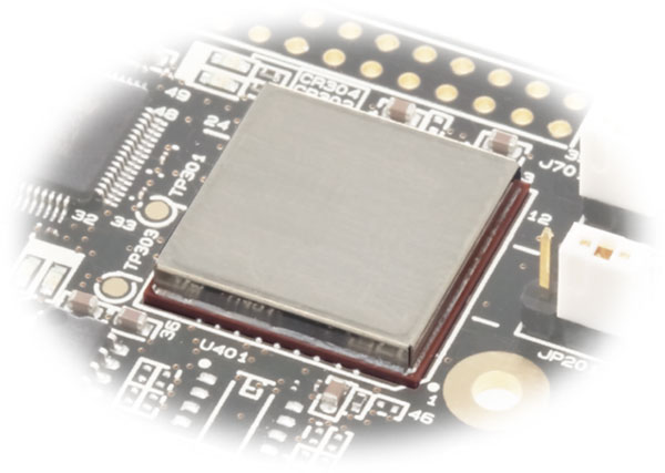
On Dec. 20, u-blox banned the use of its GNSS modules in military UAVs in the war between Russia and Ukraine. The company had become aware that its GNSS modules were being used in certain Russian reconnaissance UAVs and stated that this use was against company policy.
U-blox obtained media reports that Russia had stocked up on components in anticipation of war, then integrated products from the company in UAVs it manufactured after attacking Ukraine.
After Russia began its invasion of Ukraine, the company halted all sales to Russia, Russian territories, and Russian-occupied areas, as it intends its GNSS modules and other products to be used only commercially. U-blox company policy bans the use of its products in weapons, including systems for target identification.
U-blox is investigating the infringement of its policy and plans to take legal action if it has been violated. The company also condemns the invasion of Ukraine by Russian forces.
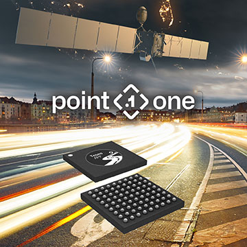
Point One’s FusionEngine software, which is rated for automotive safety integrity level (ASIL), is now compatible with STMicroelectronics’ Teseo ASIL Precise Positioning GNSS chipset (TeseoAPP). This assures functional safety as ASIL-B, a requirement for Level 3+ advanced driver assistance systems (ADAS).
FusionEngine can be integrated into several different host processors that are used for enabling high level ADAS and autonomous driving systems. The combination of TeseoAPP’s receiver and the STA5365S external RF front-end provides dual-band measurement data for all visible GNSS satellites to the main host processor into which FusionEngine is integrated.
FusionEngine software is a precise location solution for automotive applications. For accuracy and to ensure the safety and integrity required for high level autonomous vehicles it combines data from multiple sensors, including the TeseoAPP multi-band GNSS receiver. It also enables developers to complete the functional safety concept phase for host system software integration.
A roundup of recent products in the GNSS and inertial positioning industry from the December 2022 issue of GPS World magazine.
AUTONOMOUS
Flight Controller
Turns a UAV into a connected autonomous system
Photo: Auterion
Skynode reference-design hardware is built with Remote ID in mind, enabling UAV users to comply with the FCC rule Remote Identification of Unmanned Aircraft (Part 89). A built-in connectivity stack with 4G, Bluetooth and Wi-Fi enables automatic real-time data transmission from the UAV to the cloud. Built on open standards, Skynode is flexible and extensible, allowing users to leverage a variety of compatible software and hardware components. The connections enable automatic sending of logs, images and real-time video streams from the field to remote experts.
The VoloDrone is a fully electric, heavy-lift utility UAV with a range of up to 25 mi carrying a carrying a 440-lbs payload. The rotor area has a diameter of 30 ft, and the vehicle is 7.5 ft high. It can be remotely piloted or can fly autonomously on preset routes. Loads can be carried between the legs of the landing gear on standard rack mounts or slung below, or a tank and sprayer could be fitted for agricultural applications. The 18-rotor multicopter platform uses swappable lithium-ion batteries and an in-house flight control system, and benefits from existing development and test of the Volocopter air-taxi.
With a wingspan of 4.20 m, the BOREAL NRM remotely piloted aircraft integrates efficient photogrammetry devices for mapping large areas, even in areas inaccessible to traditional mapping aircraft. Its flight-control system is designed for image-capture management and optimal coverage of areas greater than 20,000 ha. The BOREAL NRM offers an overall and precise view of cultivated areas (1 cm to 3 cm per pixel), simplifying crop monitoring and facilitating human intervention in places that require it (such as water stress, treatment of pests).
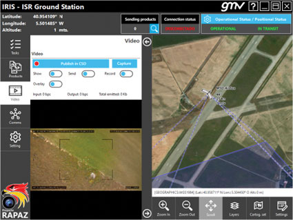
The IRIS unmanned vehicle command-and-control system provides intelligence, surveillance and reconnaissance (ISR) interoperability — essential aspects of any military operation. The IRIS system integrates unmanned vehicles with other command-and-control systems for monitoring and gathering information for a variety of operational scenarios. IRIS uses each unmanned vehicle’s own communication systems and 5G technology to provide situational awareness for decision makers before and during operations. A simplified interface allows integration of sensors and platforms into a command-and-control network, providing interoperability with other command, control, communication and computer ISR (C4ISR) systems. IRIS performed well during NATO’s REPMUS 22 (Robotic Experimentation and Prototyping Augmented by Maritime Unmanned Systems) exercise in September.
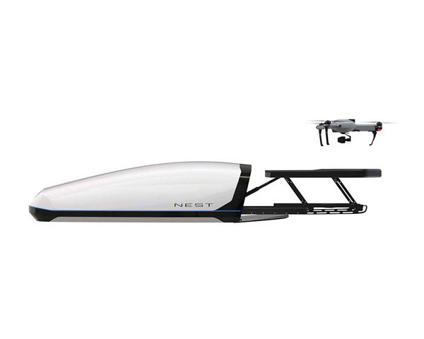
The AtlasNEST UAV system features a docking station to provide fully autonomous 24/7 readiness for infrastructure inspections, emergency situations and security missions requiring shared situational awareness and management. Using the AtlasSTATION interface, an operator sets a target destination, and the lightweight UAV deploys in less than three minutes. Sending a drone to collect visual data and reveal possible problems can help prevent putting personnel in unsafe circumstances. AtlasNEST has built-in artificial-intelligence technologies, including autonomous battery swapping. Using the AtlasSDK, AtlasNEST can be incorporated into current security systems.
Turf Tank is an autonomous, GNSS-guided line-marking robot built specifically to paint lines on athletic fields. More than 550 Turf Tank robots are deployed across the United States, painting athletic fields at public schools, major colleges and universities, amateur and professional soccer clubs, local parks and recreation departments, and at two National Football League stadiums. The Turf Tank robots can paint a full soccer field in less than 30 minutes, compared to two or three hours for manual painting. Similarly, the robot can paint a football field in two or three hours compared to eight to 10 hours to paint a football field. The robots are eco-friendly — they’re powered by rechargeable batteries and use far less paint than most older paint machines.
The Autel EVO II Pro Series combines Carlson’s software and hardware surveying and mapping solutions with a UAV from Autel Robotics. The Carlson suite is designed to take professionals throughout a project’s lifecycle: setting ground control points with the Carlson BRx7 GNSS receiver and RT4 data collector with SurvPC field software, the drone flight, PC photo and data processing, and creating finished plans in CAD.
The GPS 5 Click is a compact add-on board that provides users with positioning, navigation and timing (PNT) services. The board features the M20050-1, a GPS module using the MediaTek MT3333 flash chip and an Antenova GNSS receiver for optimum performance. The receiver tracks three GNSS constellations concurrently (GPS + Galileo + GLONASS or GPS + Galileo + BeiDou) and has configurable low-power modes operating from a 3.3V power supply. In addition to the possibility of using an external antenna, backup power, and various visual indicators, the M20050-1 has an accurate 0.5 ppm TXCO ensuring short time-to-first-fix and multipath algorithms that improve position accuracy in urban environments.
Modules GT-100, GT-9001 and GT-90 are time-synchronization GNSS receiver modules compatible with all GNSS systems. The three modules deliver nanosecond precision for 5G mobile systems, radio communications systems, smart power grids and grandmaster clocks. Each suits different applications based on supported frequency bands and output signals. GT-100 supports concurrent L1 and L5 reception and delivers three outputs including 1 pulse per second (1 PPS) synchronized with UTC as well as user-programmable frequencies. The outputs can be set to 10 MHz, 2.048 MHz and 19.2 MHz, reducing time to market and saving costs through reduced component needs. GT-9001 supports L1 and delivers high-stability 1PPS and programmable clocks on three channels. GT-90 supports L1 and provides a 1 PPS high stability output. All models have time stability of 4.5 ns (1 sigma) and are equipped with multipath mitigation to minimize degradation of performance in urban areas.
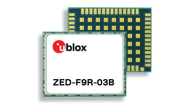
The latest firmware update for the u-blox ZED-F9R high-precision GNSS module adds support for Japan’s QZSS CLAS correction services (ZED-F9R-03B). The ZED-F9R also now supports u-blox SPARTN 2.0 correction data.
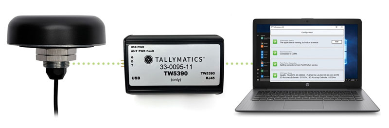
The TW5390 smart antenna has IP network and L-band augmentation service capability. Along with a Tallymatics antenna, it has a high-precision u-blox F9R GNSS receiver and DS9 L-band receiver modules. The combination delivers a reliable and convenient smart antenna yielding <6-cm accuracy, with precise point positioning/real-time kinematic (PPP/RTK) augmentation services via the PointPerfect subscription service. The antenna provides superior multipath rejection with Tallysman Accutenna technology, a low noise amplifier, Tallysman’s eXtended Filtering (XF) technology, which mitigates saturation from nearby RF signals (targeting LTE and Ligado), a tight, measured phase-center offset and low axial ratio, enabling accurate and precise positioning, direct decoding of PointPerfect, SPARTN formatted augmentation packets (u-blox specific)
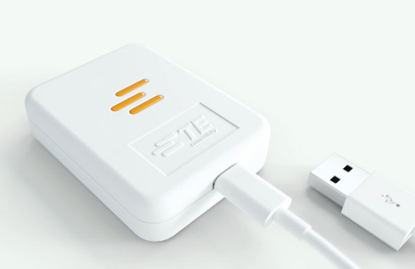
Tracking enables potential applications and projects
Photo: TE Connectivity
The Lembas LTE/GNSS USB modem provides plug-and-play GNSS tracking as well as LTE and CAT4 network connectivity via a robust USB interface to a variety of small-board computers utilizing the ARM chipset. Through a single-command setup process, users can have GNSS access to a wide variety of projects. The modem has been tested with Raspberry Pi Model B, Odroid XU4 and N2, ASUS Tinker Board, and NVIDIA Jetson Nano.
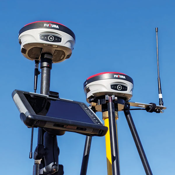
The universal construction site supervisor system is designed to help contractors manage all their job site activities. It includes the SiteMetrix Grade and the multi-frequency, multi-GNSS F631 RTK base and rover. SiteMetrix is user friendly, easy to understand and portable. Contractors can use the Futtura system to localize sites, check grade, configure base stations, set stakes and calculate volumes of material removed. Users will see the benefit of seamlessly performing data collection and layout, all in one easy-to-use application, the company says. The F631 GNSS receiver is powered by SureFix RTK technology, which offers a real-time dual-solution point verification. The F631 GNSS receiver is powered by Hemisphere GNSS’ Athena RTK technology. With Athena, F631 provides state-of-the-art RTK performance when receiving corrections from a static base station or network RTK correction system. With multiple connectivity options, the F631 allows for RTK corrections to be received over radio, cell modem, Wi-Fi, Bluetooth, or serial connection. F631 delivers centimeter-level accuracy with virtually instantaneous initialization times and robustness in challenging environments.
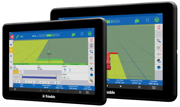
The Trimble GFX-1060 and GFX-1260 next-generation displays for precision agriculture applications enable farmers to complete in-field operations quickly and efficiently while also mapping and monitoring field information in real time with precision. Both displays feature an Android-based operating system and enhanced processing power for controlling and executing in-field work. The new flagship GFX-1260 is a 12-in (30.5 cm) display, while the GFX-1060 is a 10-in (25.6 cm) display, and both are compatible with the Trimble NAV-500 and NAV-900 GNSS guidance controllers. The displays are ISOBUS-compatible, which allows one display or terminal to control ISOBUS implements, regardless of manufacturer. The displays enable farmers to set up and configure their equipment through Trimble’s Precision-IQ field software, including manual guidance, assisted and automated steering, application controls, mapping and data logging, equipment profiles and camera feeds from attached inputs and other internet-based apps.
Enables affordable smart construction upgrades for fleets
Photo: Komatsu
The Smart Construction Retrofit kit turns a conventional Komatsu excavator “smart” with 3D guidance and payload monitoring. With a kit installed, an operator is no longer required to set up a laser or bench every time the machine moves. The kit’s GNSS receiver determines where a machine is on the job site and what the target grade is. The need for additional labor is reduced because the technology collects and delivers information directly to the operator. Designed to improve grading performance and provide more time- and cost-management tools, Smart Construction Retrofit kits can bring 3D to most Komatsu excavators in a fleet. The kit gives operators the latest design data, measures payload volumes and load counts, and allows managers to monitor production from the office by integrating Smart Construction applications. The payload meter helps prevent overloading trucks by promoting proper loading weights for on- and off-road vehicles, to reduce the potential for equipment damage and other risks.
The SAgro10 GNSS is an upgradeable entry-level guidance system for precision agriculture, which can be easily upgraded to the SAgro100 automatic steering system. Equipped with a high-precision GNSS module, the SAgro10 tracks all constellations. For users with network coverage or a UHF base station, the SAgro10 system provides centimeter-level accuracy navigation in real-time kinematic mode. In the absence of base stations, it can still provide sub-meter navigation accuracy in single-point smoothing mode. The system is compatible with most agricultural tractors and can be installed in 15 minutes. It supports a 10-in sunlight-readable touchscreen with a clear graphic interface. The SAgro10 software can intelligently manage the work area and simplify user operations, such as recording the completed work area and planning the work route.
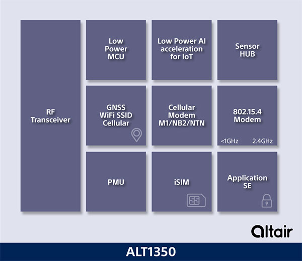
Innovative chip offers multiple ultra-low power connectivity options and low-power processing for internet of things (IoT) market
Sony Semiconductor Israel has launched the ALT1350 for the global market. The ALT1350 is a cellular LTE-M/NB-IoT chipset designed to enable additional low-power wide-area (LPWA) communication protocols, as well as GNSS, in a single chipset.
The ALT1350 incorporates a sensor hub to collect data from the sensors while maintaining ultra-low power consumption. It also provides cellular and Wi-Fi-based positioning and is tightly integrated to provide power-optimized concurrent LTE and GNSS to accommodate various tracking applications, which can be demanding with a single chip.
“The market demand for this multiprotocol, ultra-low power IoT chipset is intensifying, and Sony’s ALT1350 chipset meets that demand,” said Nohik Semel, CEO at Sony Semiconductor Israel. “This is the game changer we’ve been waiting for, which will enable IoT deployments, utilizing universal connectivity on edge processing and multiple location technologies.”
Diagram: Sony
The ALT1350 is an advanced cellular IoT solution, with architecture that resolves IoT service provider’s power-consumption concerns. Its optimized standby mode (eDRX) reduces power consumption by 80% when compared to the current generation and by 85% when using it to send short messages.
Overall improvements in the system’s power consumption will enable four times longer battery life for a typical device, enabling additional functionalities and use cases with smaller batteries.
The ALT1350’s sub-GHz and 2.4 GHz integrated transceiver enables hybrid connectivity for smart meters, smart cities, trackers and other devices. This enhances coverage, reduces costs and further decreases power consumption using IEEE 802.15.4-based protocols such as Wi-Sun, U-Bus Air and wM-Bus, in additional point-to-point and mesh technologies.
The chipset is designed to support the wide-ranging market needs of utilities, vehicle, tracking devices, smart cities, connected health and other verticals. Device manufacturers across all verticals can take advantage of its low power consumption, long-lasting battery life, mature Release 15 LTE-M/NB-IoT software stack, and future compatibility with 3GPP release 17.
All these guarantee longevity and ensure the ALT1350 will operate with 5G networks. It contains an additional LPWA radio transceiver with targeting operation in <1 GHz and 2.4 ISM bands for universal connectivity options.
The chipset provides advanced on-the-edge low power processing capabilities, ranging from data collection, low power AI/ML processing of the data, and MCU to enable IOT applications on the chip.
The device is now sampling to lead customers and will become commercially available in 2023. The ALT1350 also includes a secure element for application usage and integrated SIM designed for PP-0117 to meet GSMA requirements.
Linx Technologies, now part of TE Connectivity, has expanded on its Splatch antenna series with the release of the ANT-GNL1-nSP, a surface-mount embedded GNSS antenna supporting GPS, Galileo, GLONASS, Beidou and QZSS in the L1/E1/B1 bands.
“The new linear GNSS antenna from Linx expands upon our already robust embedded PCB antenna portfolio of customer favorites like the uSP410, SP610 and the nSP250, by adding a GNSS solution,” said Rick Stuby, vice president of product management. “The antenna displays high performance in a compact surface-mount package, making it especially well-suited for small devices in the growing internet of things market.”
The ANT-GNL1-nSP antenna exhibits notable performance in a compact size (10 mm x 8 mm x 1 mm) and features linear polarization and an omnidirectional radiation pattern. The antenna is available in tape and reel packaging and is designed for reflow-solder mounting directly to a printed circuit board for high-volume applications.
The new GNSS antennas are available now via Linx Technologies’ distributor and manufacturer representative networks. For larger quotes, email Linx Technologies at [email protected].
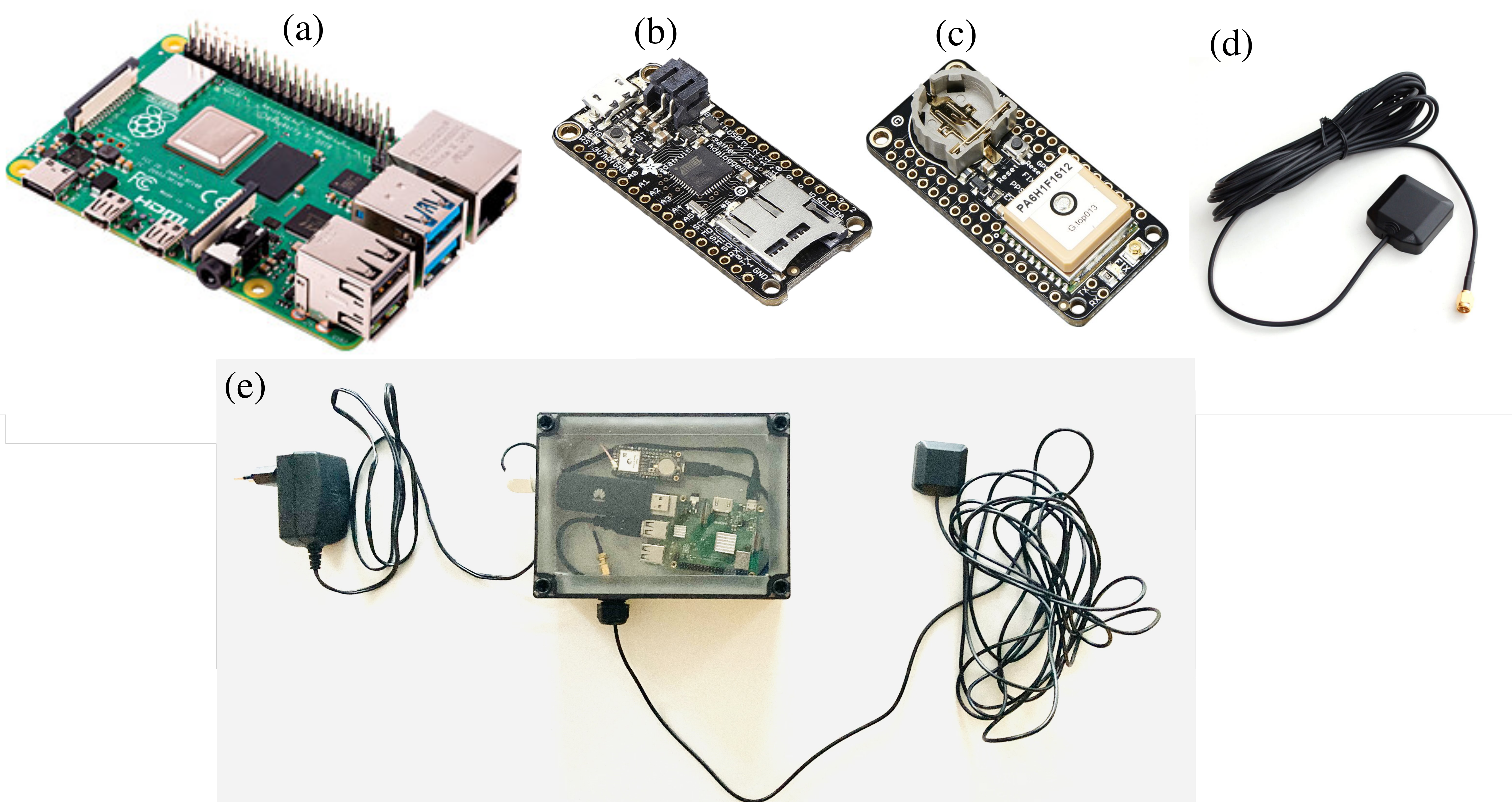
A team of researchers has developed a low-cost sensor that can detect the changes in river height to provide wide-area flood warnings.
The Raspberry Pi Reflector (RPR) was designed by a team of scientists from the University of Bonn, the Federal University of Rio Grande do Sul, and the University of Colorado.
The solar-powered RPR is much less expensive (about US$150) than scientific-grade or geodetic GNSS instruments — the cost of which is “a limiting factor for their prompt and more widespread deployment as a dedicated environmental sensor,” the team writes in their paper.
The Raspberry Pi Reflector (RPR) prototype includes a low-cost and low-maintenance single-frequency GPS module (an Adafruit GPS FeatherWing receiver) and an unspecified GPS antenna connected to an inexpensive Raspberry Pi microcomputer. One such unit has been successfully operating since March 2020 in Wesel, Germany, next to the Rhine river.
The RPR hardware array: (a) Raspberry Pi 4 Model B (b) Adafruit Feather Adalogger microcontroller (c) Adafruit GPS FeatherWing receiver (d) GPS external antenna (e) Configuration of RPR prototype setup. (Image: Karegar, et al)
The unit on the Rhine provides sub-daily and daily water levels retrieved using spectral analysis of reflection data, or GNSS-reflectometry. The river level measurements from the RPR are compared with a co-located river gauge.
By changing the orientation of the antenna from upright to sideways facing the river, which was done in August 2021, the root-mean-square error (RMSE) was lowered to from 7.6 cm to 3 cm (sub-daily) and 6 cm to 1.5 cm (daily), the team said.
“While satellite radar altimetry techniques have been utilized to monitor water levels with global coverage, their measurements are associated with moderate uncertainties and temporal resolution,” the team states. “Therefore, such low-cost and high-precision instruments can be paired with satellite data for calibrating, validating and modeling purposes.”
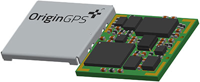
OriginGPS is exhibiting a new GNSS module based on a MediaTek chipset at Electronica in Munich this week.
The company is also demonstrating how the OriginIoT system — equipped with a high-stability GNSS module from the company’s miniature range — can be speedily deployed to replace traditional control systems, providing a new way to remote-control devices that move.
Also on show is a weather board equipped with a range of sensors for multiple particulate matter, with data presented on a gauge-rich dashboard updated automatically.
ORG600-MK01, OriginGPS’ new sub-1m precision dual-frequency module, is built with MediaTek’s chipset. (Image: OriginGPS)
“We are excited to be launching our latest GNSS dual-frequency module, the ORG4600-MK01, at the Electronica trade fair this month,” said Haim Goldberger, OriginGPS’ Founder and CEO. “At GITEX 2022 in Dubai, we heard from visitors how demands for more precision and lower costs were on the rise. Thanks to the tenacity of our engineering team, the solution has sub-1m precision and is competitively priced. In fact, the cost of our new module — built with MediaTek’s dual-frequency chipset — is lower than that of our first L1+L5 module, the ORG4600-B01, which is based on Broadcom’s chipset and provides high stability with up to 10cms accuracy.”
The new 10 mm x 10 mm dual-frequency GNSS product is based on 12 nm technology and was designed for applications deployed in challenging environmental conditions. The solution also includes RTCM, a logger and accurate orbit prediction.
OriginGPS is showcasing its miniature GNSS modules and cellular IoT systems and devices in Booth B5-242 at Electronica, Munich, Nov. 15-18.
A roundup of recent products in the GNSS and inertial positioning industry from the November 2022 issue of GPS World magazine.
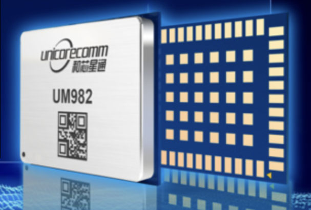
OEM
GNSS Module
For UAV, precision agriculture and autonomous machines
Photo: Unicore Communications
The UM982 GNSS module is a high-precision, dual-antenna real-time kinematic (RTK) positioning and heading module. It supports BeiDou B1I/B2I/B3I; GPS L1/L2/L5; GLONASS L1/L2; Galileo E1/E5a/E5b, QZSS L1/L2/L5; and SBAS in dual-antenna mode. The highly integrated, compact (16 mm × 21 mm × 2.6 mm) module can reduce the design area of an OEM board by 72% compared to previous modules. Power consumption is less than 0.6 W. The NebulasIV GNSS system-on-chip is a key part of the UM982’s navigation system. The NevulasIV integrates RF, baseband and high-precision algorithms on a single chip, with supporting functions built in. High-level performance indicators include raw observation accuracy, RTK positioning accuracy, precise point positioning accuracy, and time to first fix. The two antennas can independently participate in deriving an RTK solution and outputting the positioning results.
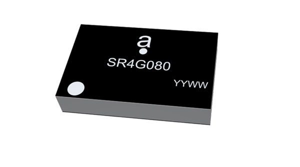
Alternative to ceramic patch provides omni-directional performance
Photo: Antenova
The Agosti (part number SR4G080) is a new miniature surface-mount-designed (SMD) antenna for GNSS applications. It measures 9.0 mm x 5.8 mm x 1.7 mm and operates with exceptional efficiency in a reduced space on a corner of a printed circuit board. It has a small ground-plane requirement of 40 mm x 20 mm, 70 mm x 25 mm and 80 mm x 30 mm, making it suitable for small form-factor designs such as wearable devices, trackers and onboard diagnostics.
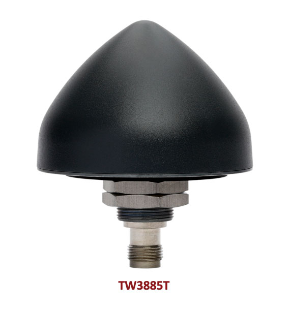
Housed Dual-Band antenna with Accutenna technology
Photo: Tallysman
The dual-band TW3885T antenna supports GPS/QZSS L1/L5; Galileo E1/ E5a/b; BeiDou B1/B2/B2a; GLONASS G1/G3; and satellite-based augmentation systems in the region of operation: WAAS (North America), EGNOS (Europe), MSAS (Japan) or GAGAN (India). It is housed in a through-hole mount, weatherproof (IP69K) enclosure. It mitigates the effects on GNSS receivers of new signals or harmonic frequencies from adjacent LTE bands on the radio-frequency spectrum. For permanent installations, L-bracket (PN 23-0040-0) or pipe (23-0065-0) mounts are available. Tallysman provides an antenna installation guide that recommends a 100 mm –125 mm ground plane and provides antenna installation and cable connector waterproofing best practices.
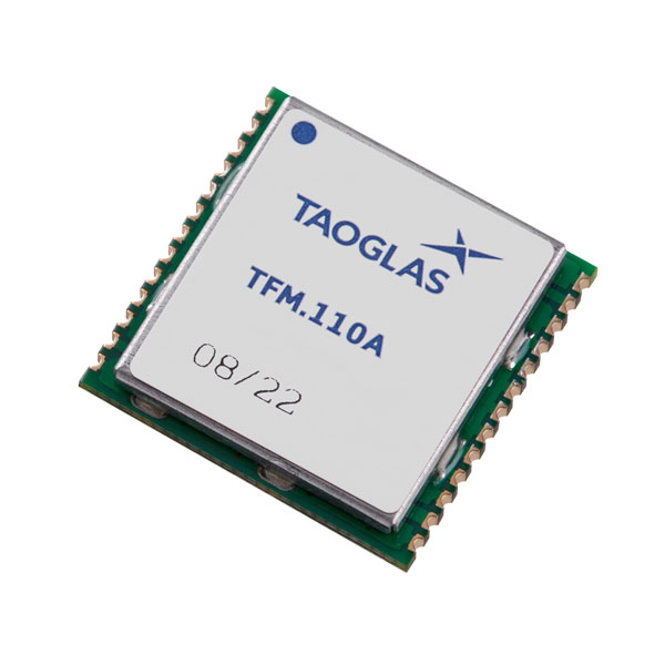
Simplifies product development for high-precision applications
Photo: Taoglas
The TFM.110A is the first in a new series of high-precision, multi-band GNSS front ends for autonomous vehicles, precision agriculture, automotive applications and robotics. It comes fully integrated with two cascaded low noise amplifiers (LNA) and pre-filters in a small, low-profile, shielded surface-mount package. When used between the device’s GNSS receiver and antenna, the two-stage amplifier solution eliminates the need for complex and challenging onboard filter and amplifier circuits. It supports L1, L2 and L5 bands and enables seamless signal transmission, signal purity and position accuracy in high-precision applications.
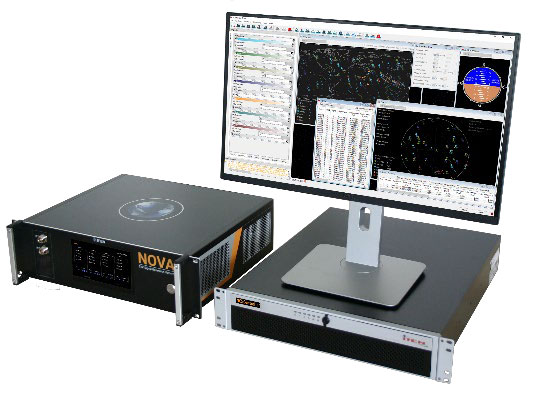
Provides interference, spoofing, encryption and authentication capability
Photo: IFEN GmbH
Version 2.8 of the NCS Nova RF signal simulator offers advanced capabilities. With integrated interference generation capability, the Nova can generate coherent interference signals with a signal power of up to –30 dBm. The ability to assign two users to one RF output enables integrated spoofing scenarios with a single RF output, meaning spoofing is available even with an entry-level single RF Nova. The new release has advanced navigation message authentication simulation capability compliant to User ICD 1.0 for the Galileo E1-B OSNMA, meaning specific OSNMA events can be simulated — key to ensuring compliant receiver behavior. Supported events include renewal and revocation of both a public key and a TESLA keychain. GPS cross-authentication and generation of Galileo E6-C encrypted codes are also supported.
Enables first responders to locate callers on floor levels
Photo: Polaris Wireless
Z-axis location service enables the pinpointing of a smartphone user within one floor level inside a multi-story building. The technology — demonstrated to meet the 3-meter vertical location accuracy requirement of the Federal Communications Commission (FCC) — is integrated into Schok Gear’s newly released flip phones. The Schok phones provide consumers with a simple, powerful device. Adding indoor and vertical location to these phones enables first responders to locate all wireless 911 callers with floor-level accuracy in multi-story buildings.
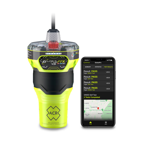
The new ACR Electronics GlobalFix V5 Emergency Position-Indicating Radio Beacon (EPIRB) and ResQLink AIS Personal Locator Beacon (PLB) have integrated the automatic identification system (AIS) to increase the speed of location and aid. They also are compatible with Return Link Service (RLS) alerting. The combination of services ensures faster rescue and increases chance of survival of both boat (EPIRB) and crew (PLB). The safety beacons deliver mobile connectivity to a cell phone with a free mobile app, made possible with the addition of near-field communication technology in the beacons. With the app, users can monitor their beacons, review self-test results, view GNSS test locations, and monitor beacon performance and maintenance by scanning the beacons with their mobile phones. Besides GNSS positioning, the lightweight beacons have 406-MHz Cospas-Sarsat distress signal with MEOSAR compatibility and 121.5-MHz local homing signal.
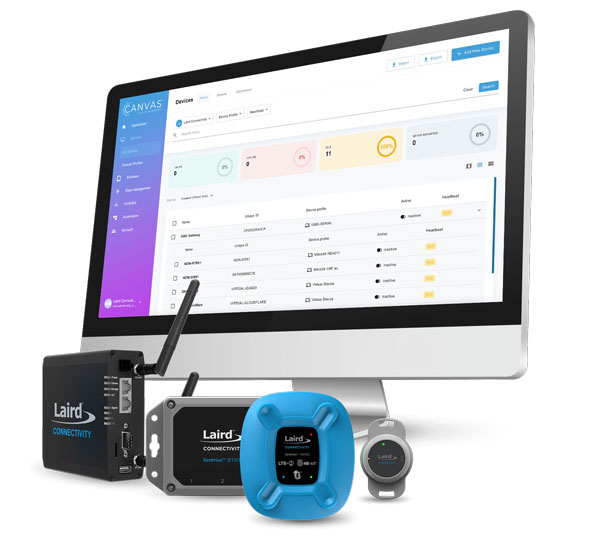
The Canvas Device Manager simplifies workflows for configuration and maintenance of internet of things (IoT) device deployments. It enables users to easily set up devices, monitor performance, and keep software up-to-date across the entire IoT device fleet. Device parameters can be remotely managed, and performance monitored. Canvas enables users to organize large numbers of devices to quickly build and maintain IoT solutions, and software updates can be remotely and rapidly deployed, thwarting security attacks.
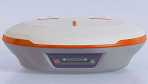
The N2 Palm RTK GNSS receiver is suitable for surveying, mapping and construction. It has a highly integrated main board and a three-in-one antenna, yet weighs 0.72 kg with battery and measures 48 mm. Powered by ComNav’s SinoGNSS K8 high-precision module, the N2 can track 1,590 channels, including all existing and planned signals of GPS, BDS-2, BDS-3, GLONASS, Galileo, QZSS and SBAS. Its advanced satellite-tracking technology ensures it works well even in harsh environments, such as under heavy foliage or close to buildings. A third-generation inertial measurement unit (IMU) makes the N2 immune to magnetic disturbance, which greatly improves its reliability. Pole-tilt compensation of up to 60° allows surveyors to locate points within 2.5 cm. By using the company’s Quantum algorithm, the N2 achieves calibration-free operation — after 10 seconds of initialization, users can make tilt measurements with centimeter-level accuracy for an extended period, greatly improving efficiency.
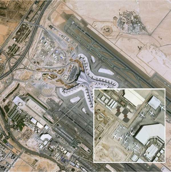
Airbus has added 30-cm Pléiades Neo imagery to its OneAtlas Living Library service. The new data source will complement the service which already allows users to instantly access a premium catalogue of Pléiades 50 cm and SPOT 1.5 m data via streaming, download and API. The Living Library provides frequent updates over urban areas, airports, harbors and military sites to name a few. Imagery is updated every day and processed in the cloud, with flexible options for integration into GIS workflows. With the OneAtlas Living Library, Airbus offers a pay-per-order option but also a subscription-based service that allows users to access premium content quickly available into their account, as well as a deeper archive of more than 10 years of imagery by Pléiades and SPOT satellites at a higher incidence angle and cloud coverage threshold, which will be available in just a few hours. OneAtlas also provides access to several other data services, such as reactive tasking, that allows users to task a full suite of optical and radar satellites, including Pléiades Neo, or access more than 15 years of global radar data, as well as the ability to download the WorldDEM product suite among others.
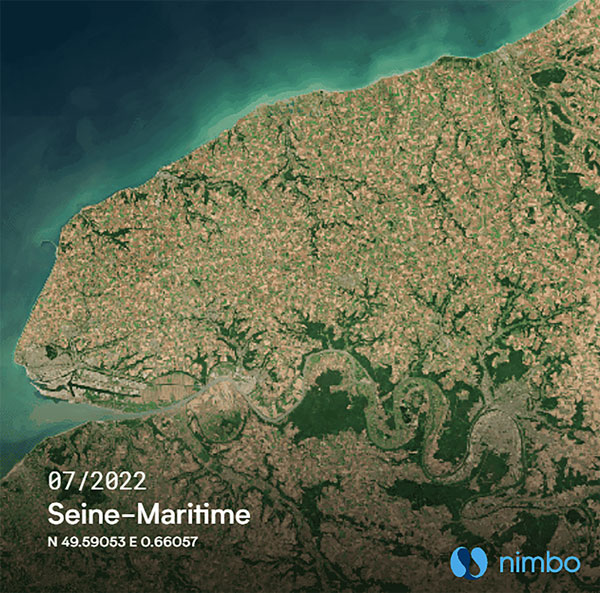
Free, user-friendly tool shows the Earth’s changes
Photo: Kermap
The Nimbo Maps platform provides monthly 10 m-resolution images of changes on Earth in a user-friendly format. The images are chronological, seamless and free of clouds, and include intuitive comparison timelapse features. The platform, developed by French startup Kermap, relies on innovative artificial intelligence methods to process satellite images supplied by the European Union’s Copernicus program through its Sentinel missions. APIs automatically retrieve data extracted from satellite imagery, providing Kermap customers with real-time, strategic, value-added information in the fields of agriculture, land planning and environmental transitions. Current coverage includes Europe, the Middle East and the United States, with plans to provide global coverage by early 2023.
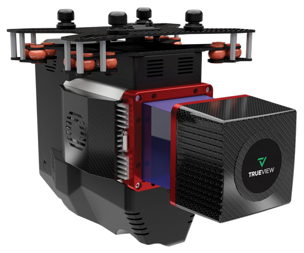
The TrueView 655/660 3D imaging system uses the Riegl miniVUX-3UAV laser scanner and three fully integrated mapping cameras (right, left and nadir) for high-accuracy mapping with excellent vegetation penetration and wire detection. Previous TrueView 3D systems carried dual oblique cameras to maximize mapping coverage. The TrueView 655/660 adds a third RGB camera, allowing for imagery directly below the sensor to be captured. The third camera provides a direct view of the ground below to maximize data collection for time flown, while improving the quality of photogrammetry and colorized point clouds.
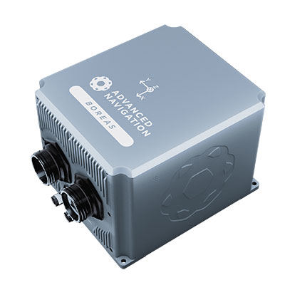
The D70 is the latest release in the Boreas digital FOG (DFOG) series, offering a new performance grade with superior accuracy, exceptional stability and reliability. The technology is suited to surveying, mapping and navigation across subsea, marine, land and air applications.
“We are thrilled to expand the Boreas series with the D70. It’s a system that will provide additional flexibility in the Boreas family, making ultra-high accuracy inertial navigation far more affordable than with previous FOG INS systems,” said Xavier Orr, CEO and co-founder of Advanced Navigation. “This patented technology opens the possibility for adopting FOG INS systems across a much broader range of vehicular applications, particularly autonomous vehicles and aircraft where weight and size are at a premium.”
Boreas D70 combines closed-loop DFOG and accelerometer technologies with a dual-antenna real-time kinematic (RTK) GNSS receiver. These are coupled with Advanced Navigation’s artificial-intelligence-based fusion algorithm to deliver accurate and precise navigation.
The system features ultra-fast gyrocompassing, acquiring and maintaining an accurate heading under demanding conditions. While the D70 does contain a GNSS receiver, it is not required for gyrocompass operation.
Based on the company’s DFOG technology, the D70 delivers a 40% reduction in size, weight, power and cost (SWaP-C) when compared to systems of similar performance.
0.01° roll and pitch
0.1° secant latitude heading (gyrocompass)
0.01°/hour bias instability
10 mm position accuracy
The Boreas Series
The Boreas DFOG series features ultra-fast gyrocompassing and can acquire heading, either stationary or dynamically, in less than two minutes. The gyrocompassing allows the system to determine a highly accurate heading without any reliance on magnetic heading or GNSS.
The technology stems from Advanced Navigation’s artificial intelligence sensor-fusion algorithm allowing the system to extract significantly more information from the data. It is designed for control applications, with a high level of health monitoring and instability prevention to ensure stable and reliable data.
Advanced Navigation designed Boreas from the ground up for reliability and availability. The hardware and software are designed and tested to international safety standards and have been environmentally tested to MIL-STD-810. The system achieves a mean time between failure (MTBF) of more than 70,000 hours.
Additional features of the Boreas D70 include Ethernet, CAN and NMEA protocols, as well as disciplined timing via a PTP server and 1 PPS. An embedded web interface provides full access to all of the device’s internal functions and data. Internal storage allows for up to 1 year of data logging.
About DFOG Technology
DFOG is patented technology, which has been developed over 25 years involving two research institutions. DFOG was created to meet the demand for smaller and more cost-effective FOGs, while increasing reliability and accuracy.
The first generation of FOG, made available in 1976, used analog signals and analog-signal processing. The second generation was developed in 1994 and is still used to this day. It improved upon the first generation with a hybrid approach using an analog signal in the coil with digital signal processing.
In 2021, FOG evolved into DFOG. This third generation of FOG sets itself apart by being completely digital, providing higher performance and reliability while enabling a 40% reduction in SWaP-C.
To achieve this, three different yet complementary technologies have been developed to improve the capabilities of FOG.
Digital Modulation Techniques. DFOG uses a specially developed digital modulation technique passing spread spectrum signals through the coil. The new digital modulation technique introduced in DFOG technology allows in-run variable errors in the coil to be measured and removed from the measurements. This makes DFOG significantly more stable and reliable than traditional FOGs. It also allows a smaller FOG with less coil length to achieve the accuracy of one with a longer coil.
Revolutionary Optical Chip. By integrating five sensitive components into a single chip and removing all the fiber splices, the size, weight and power are reduced considerably while significantly improving reliability and performance.
Specially Designed Optical Coil. DFOG employs a specially designed closed-loop optical coil, developed to take full advantage of the digital modulation techniques. The design allows for optimum sensing of in-run variable coil errors using the new digital modulation technique. It also provides a very high level of protection for the optical components from shock and vibration.
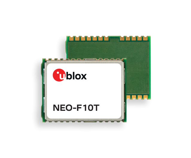
New receiver provides a path to the security and performance benefits of dual-band technology
Photo: u-blox
U-blox has announced a new, compact dual-band timing module that offers nanosecond-level timing accuracy, thereby meeting the stringent timing requirements for 5G communications.
The new u-blox NEO-F10T is compliant with the u-blox NEO form factor (12.2 mm x 16 mm), allowing space-constrained designs to be realized without the need to compromise on size.
The NEO-F10T is the successor to the NEO-M8T module, providing an easy upgrade path to dual-band timing technology. This allows NEO-M8T users to access nanosecond-level timing accuracy and enhanced security.
U-blox’s dual-band technology mitigates ionospheric errors and greatly reduces timing error, without the need of an external GNSS correction service. Additionally, when within the operational area of a satellite-based augmentation system (SBAS), the NEO-F10T offers the possibility to improve the timing performance by using the ionospheric corrections provided by the SBAS system.
As the NEO-F10T supports all four global satellite constellations and L1/L5/E5a configuration, it significantly simplifies global deployments because the same device can be used universally.
NEO-F10T includes advanced security features such as secure boot, secure interfaces, configuration lock and T-RAIM to provide the highest-level timing integrity. This ensures that reliable, uninterrupted service is delivered as any attempt to interfere with the receiver is unlikely to be successful. Additionally, advanced anti-jamming and anti-spoofing algorithms are included to further enhance security.
The module has a single RF input for all the GNSS bands and dual SAW filters for exceptional signal selectivity and out-of-band attenuation. It is compatible with u-blox’s ANN-MB1 L1/L5 multi-band antenna, making it simple to evaluate the performance of the timing modules. The devices operate from a single 2.7 V to 3.6 V supply and draw just 19 mA (@ 3.0 V) during continuous operation.
“NEO-F10T is designed to meet the timing synchronization requirements in 5G small cells and private networks on a global scale. By significantly reducing the time error of cellular network synchronization, the NEO‑F10T module will help operators maximize the performance of their networks and so optimize the return on their investment in 5G communications,” said Samuli Pietila, Director Product Line Management, Timing and Infrastructure, at u-blox.
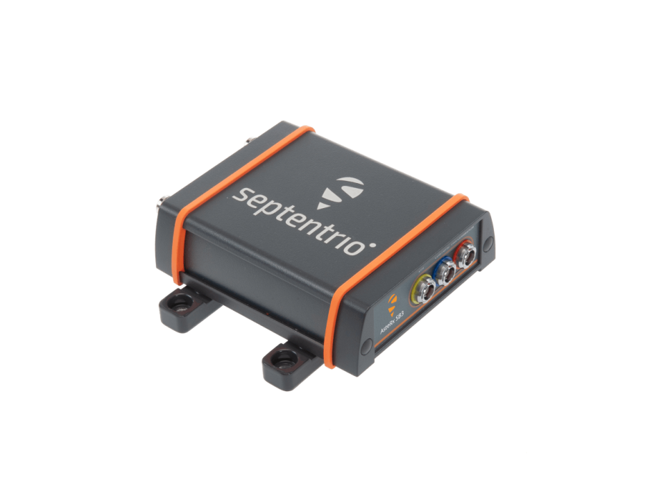
Septentrio, a leader in high-precision GNSS positioning solutions, introduced the AsteRx SB3 ProBase, the latest generation of GPS/GNSS base station receivers, designed for the creation of top-quality measurements for RTK and differential corrections.
The AsteRx SB3 ProBase is an IP68-housed GNSS base station receiver, featuring the latest quad-constellation GNSS technology for the best quality measurements. The new ruggedized receiver complements the SB3 receiver family: the AsteRx SB3 Pro, rover receiver, the AsteRx SB3 Pro+ rover and base receiver and the AsteRx SB3 CLAS, dedicated to the Japanese market.
“Customers often look for a simple, high-quality and easy-to-integrate base station to set up local high precision RTK or to densify their network and the AsteRx SB3 ProBase is the perfect solution,” said Silviu Taujan, Product Manager at Septentrio. “Thanks to its configuration flexibility and monitoring capabilities it is extremely easy to deploy and configure the SB3 ProBase. Plus, it comes with our industry-leading GNSS+ technologies, including anti-jam and anti-spoofing technology (AIM+) for unbeatable robustness and reliability.”
AsteRx SB3 products are pin-to-pin compatible with Septentrio’s popular AsteRx SB ProDirect receiver and with the recently released AsteRx SBi3 GNSS/INS system, making it simple to change receivers.
Swift Navigation, a San Francisco-based GNSS tech firm, announced that it has completed $100 million in Series D Round financing. The financing round was led by SK Inc. and Potentum Partners with strong support from Swift’s existing investors. Swift’s technology powers several of the largest automotive and commercial vehicle fleets on the road today, supporting enhanced navigation and ADAS.
New investors include FM Capital, OVN Capital, TELUS Ventures, TWM Venture Co., Buckley Ventures, Schox Venture Capital and additional independent investors.
“We are delighted to be the lead investor for this financing transaction as part of our investment strategy in high-tech software companies,” said Subeom Lee of SK Inc. “We believe that Swift will contribute to advancing the new era of driverless technology.”
David Simons, founding partner of Potentum Partners, stated, “Centimeter-level position accuracy on a continent-wide scale is impressive enough, but what really excites us is Swift’s ability to provide it with extraordinary reliability, putting absolute-position data at the core of safety-critical features in automotive, automation and machine control,”
Since its Series C Round of financing, Swift has refined its global, centimeter-accurate precise positioning service and expanded its coverage across continents to meet the needs of an on-demand economy requiring higher levels of autonomy. Swift’s customers span the globe and include automotive OEMs and Tier 1s, last-mile delivery providers, mobile handset and application providers and those building rail, industrial machine control and IoT platforms for mass-market applications.
“We have an amazing group of investors behind us and are honored to see the many customers who are using Swift technology at such incredible scale as they build the future of transportation and automation,” says Swift CEO Timothy Harris. “[We thank] our loyal partners and investors at NEA, Eclipse and EPIQ and […] welcome the support of our new investors to help us deliver precise positioning across the world.”