Septentrio has signed a distribution partnership with Braemac for North America and Mexico. Braemac will distribute the full Septentrio portfolio including the compact mosaic module family, OEM boards, GNSS enclosures and GNSS/INS solutions for demanding industrial applications.
Braemac distributes electronic components in the North American market and offers GNSS antennas, wireless connectivity solutions and other products, which are complementary to the Septentrio portfolio.
Septentrio’s advanced GNSS chipset and proprietary algorithms provide consistent pinpoint accuracy for its receivers. The built-in advanced interference mitigation technology ensures resilience to GNSS jamming and spoofing, making Septentrio’s GNSS and GNSS/INS receivers a suitable positioning component in any robotic, UAV or machine control system.
Septentrio will be exhibiting at the AUVSI XPONENTIAL conference in Denver, Colorado, on May 9 -11 at booth 4912. On Tuesday May 9, GNSS experts from Septentrio as well as other UAV integrators will share their experience in the panel discussion about “The Importance of GNSS Security in UAV Applications”.
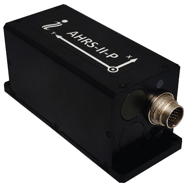
Inertial Labs has released its new attitude and heading reference system, the AHRS-II-P. This device is an enhanced, high-performance strapdown system that determines absolute orientation (heading, pitch and roll) for any mounted device. The AHRS-II-P can determine orientation for both motionless and dynamic applications.
The AHRS-II-P contains a tactical-grade inertial measurement unit (IMU) consisting of three high-precision MEMS accelerometers, three advanced MEMS gyroscopes and a high-precision, gyro-compensated, embedded fluxgate compass. It also uses 8 mm fluxgate magnetometers.
This device is suitable for a variety of devices such as UAVs, antennas, ships and robotic devices.
The HC990XF helical antenna is designed for precise positioning, covering the GPS/QZSS L1/L2/L5, QZSS L6, GLONASS G1/G2/G3, Galileo E1/E5a/E5b/E6, BeiDou B1/B2a/B2b/B3, and NavIC L5 frequency bands. This includes the satellite-based augmentation system (SBAS) available in the region of operation as well as L-band correction services.
The HC990XF has a base diameter of 64 mm, is 37 mm tall and weighs 45 g. Its precision-tuned helical element provides full GNSS band coverage, suitable gain and axial ratio, and a tight phase center. The antenna base has an SMA (male) connector, three screw holes for secure attachment and an O-ring to waterproof the antenna connector.
The HC990XF helical design does not require a ground plane, making it a suitable antenna for UAV applications.
The HC990XF antenna also supports Tallysman’s eXtended Filtering technology.
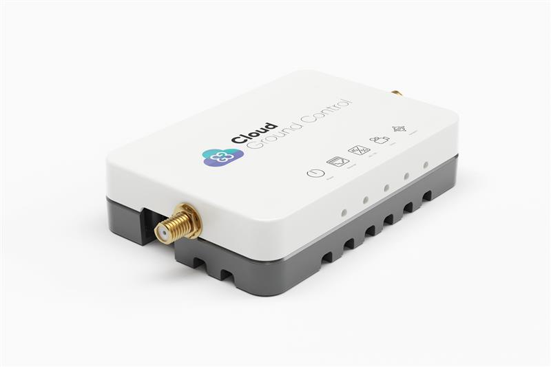
Credit: Cloud Ground Control by Advanced Navigation
Cloud Ground Control, an Advanced Navigation company, has released its cellular micro-modem, the CGConnect. Using 4G/5G networks, CGConnect links UAVs or robotic vehicles to Cloud Ground Control’s cloud-based UAV fleet management platform — enabling live-streaming, command and control from a web browser.
CGConnect can securely connect UAVs and vehicles into one autonomous fleet across land, sea and air, regardless of manufacturer or model. This provides mission planners and operators with full situational awareness for search and rescue, emergency response and disaster relief.
Artificial intelligence (AI) algorithms run in the cloud, relaying real-time camera feed data to the end user to support missions such as object detection, tracking and thermal imaging. The flexible and customizable open platform operates on industry standards, which multiplies potential product applications and enables autonomous vehicles and payloads to operate as a coordinated fleet.
CGConnect’s high-grade security safeguards data and IP from vulnerabilities and security breaches, helping users meet compliance obligations. Additionally, CGConnect supports edge AI to perform intensive object identification and classification directly on the vehicle for dynamic missions.
CGConnect is available for pre-order. An OEM option is also available.
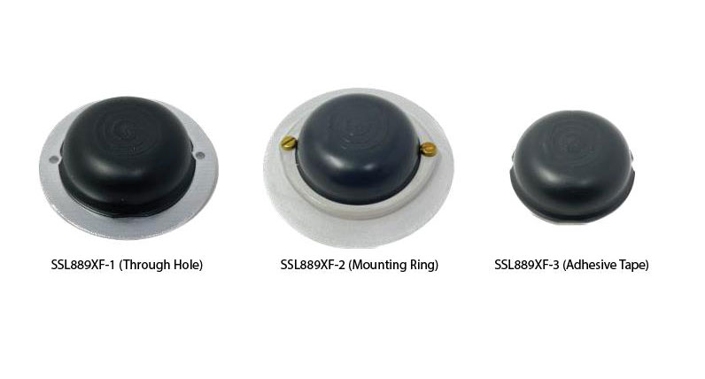
Tallysman Wireless has added the SSL889XF dual-band GNSS antenna to its line of GNSS products.
The SSL889XF employs Tallysman’s Accutenna technology providing GPS, QZSS L1/L2, GLONASS G1/G2/G3, Galileo E1/E5b, and BeiDou B1/B2b coverage. The SSL889XF antenna is designed for precision dual-frequency positioning where a light weight and a low profile are important.
The SSL889XF antenna element is 48 mm in diameter and 20 mm tall and weighs ~50 g. It has a tight average phase center variation of less than 10 mm for all frequencies and overall azimuths and elevation angles.
The SSL889XF is available in three versions. Model SSL889XF-1 has an integrated 61 mm ground plane and two mounting holes. Model SSL889XF-2 has a mounting collar, and model SSL889XF-3 is the antenna only and is attached using adhesive tape.
All models have a female MCX connector.
The SSL889XF antenna also supports Tallysman’s eXtended Filtering (XF) technology.
A roundup of recent products in the GNSS and inertial positioning industry from the April 2023 issue of GPS World magazine.
TIMING
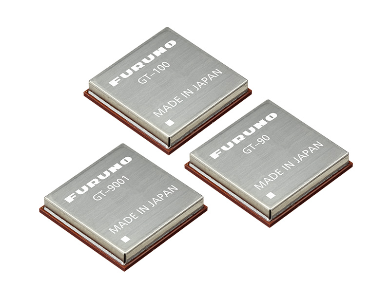
Image: Furuno
Global Timing Module Supports L1 and L5 GNSS signals
GT-100 is compatible with all GNSS constellations. The GT-100 realizes high robustness and standard of time accuracy and stability. The GT-100 features advanced multipath mitigation, anti-jamming and anti-spoofing as well as short-term holdover, ensuring superior performance even if L1 or L5 are jammed. The module delivers nanosecond precision for 5G wireless systems, radio communications systems, smart power grids and grand master clocks. Along with the GT-100, GT-9001 and GT-90 achieve a level of time stability of 4.5ns (1σ) and offer superior features and performance. Furuno, furuno.com
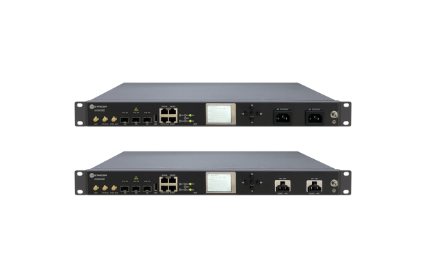
Image: UTStarcom
PTP Grandmaster Designed for mobile networks
The SyncRing XGM30E precision time protocol (PTP) grandmaster is designed for mobile networks and other applications requiring accurate time and frequency synchronization. It is an addition to the SyncRing line of network synchronization equipment. The SyncRing XGM30E is an indoor PTP grandmaster offering echo time accuracy of more than ±40 ns, which can meet the stringent timing requirements of demanding applications, including 4G and 5G networks. The clock complies with the PTP IEEE 1588-2008 standard, supporting major ITU-T frequency and phase and time profiles. SyncRing XGM30E supports synchronous Ethernet (SyncE) output on all service interfaces for accurate frequency synchronization, and SyncE input for enhanced time holdover operation during GNSS outages. The grandmaster includes an indoor rack-mount design and power supply redundancy with AC or DC built-in options and has flexible management options. The SyncRing XGM30E is available now.
UTStarcom, utstar.com
Image: Huber+Suhner
Copper-Free Data System For precise timing synchronization for high-performance networks
The GNSS and Power over Fiber GPSoF System receives, transmits and expands GNSS timing signals for the purpose of timing synchronization in data centers, central offices, distributed antenna systems or enterprise applications. It enables greater distances between the radio frequency source and the receiver system. It is also immune to RFI, EMI and EMP, contains remote control and monitoring via a web interface, and supports infrastructure installation due to direct GNSS signal evaluation.
Huber+Suhner, hubersuhner.com
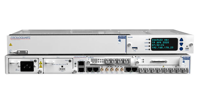
Image: ADVA
M-Code Device With advanced timing for military applications
The OSA 5422 grandmaster clock meets key requirements of military networks by providing advanced positioning, navigation and timing (PNT) capabilities and improved resilience. The OSA 5422 grandmaster clock is integrated with a highly reliable M-code receiver, which meets stringent frequency and phase synchronization needs. The device is equipped with multi-band, multi-constellation GNSS receivers for when M-code is not available. The OSA 5422 also has long holdover and precision time protocol backup, which enables it to maintain accurate timing even in the event of M-code disruption. The OSA 5422 supports legacy interfaces such as BITS and IRIG and features eight field-upgradable 10G bit/s ports and 1G bit/s interfaces. The device is suitable for most demanding military edge applications.
ADVA, adva.com; Brandywine Communications, brandywinecomm.com
AUTONOMOUS
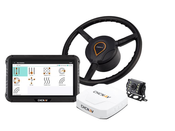
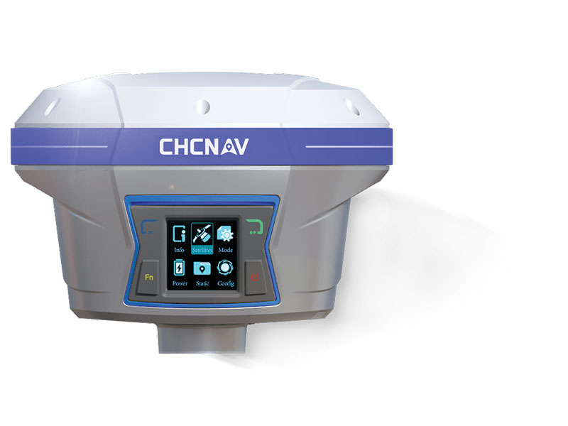
Image: CHC Navigation
GNSS RTK Steering System Suitable for agriculture applications
The NX510 SE Auto-Steer is an automated steering system that retrofits several types of new and old farm tractors and other vehicles. It can be connected to local real-time kinematic (RTK) networks or GNSS RTK base stations. NX510 SE is a guidance controller powered by multiple corrections sources and five satellite constellations: GPS, GLONASS, Galileo, BeiDou and QZSS. It has a built-in 4G and UHF modem that connects to all industry-standard differential GPS and RTK corrections to achieve centimeter-accuracy steering. NX510 SE contains GNSS and inertial navigation system terrain compensation technology, which maintains high accuracy in challenging environments and terrain. This makes NX510 SE suitable for ditching, planting and harvesting applications. In addition, AgNav multilingual software, operating on a 10.1 in industrial display, supports multiple guideline patterns that include AB line, A+ line, circle line, irregular curve and headland turn. CHC Navigation, chcnav.com
Image: Trimble
Module for Rail Monitoring For automated and semi-automated rail monitoring
The T4D Rail Module enables simple data collection and reduces office work required to automate movement detection for rail monitoring projects. The T4D software offers four main elements for automated monitoring: sensor management and data integration for GNSS; total station, geotechnical, vibration and environmental sensors; geodetic processing and adjustments for accurate results; analysis and visualization through several tools that provide real-time updates to support in-depth analysis and data presentation; and alarming and reporting. The T4D Rail module enables integration of rail as-builts collected with the Trimble GEDO system or with a track measuring bar paired with the Trimble Access Gauge Survey app. It also can automate calculations for track geometry parameters, generate analysis charts, and trigger alarms. The T4D software is offered in five editions to fit various project requirements. The editions include T4D Access, T4D Field, T4D Intermediate, T4D Geotechnical and T4D Advanced. T4D Access and T4D Advanced are the two editions that support the add-on Rail Module. Trimble Geospatial, geospatial.trimble.com
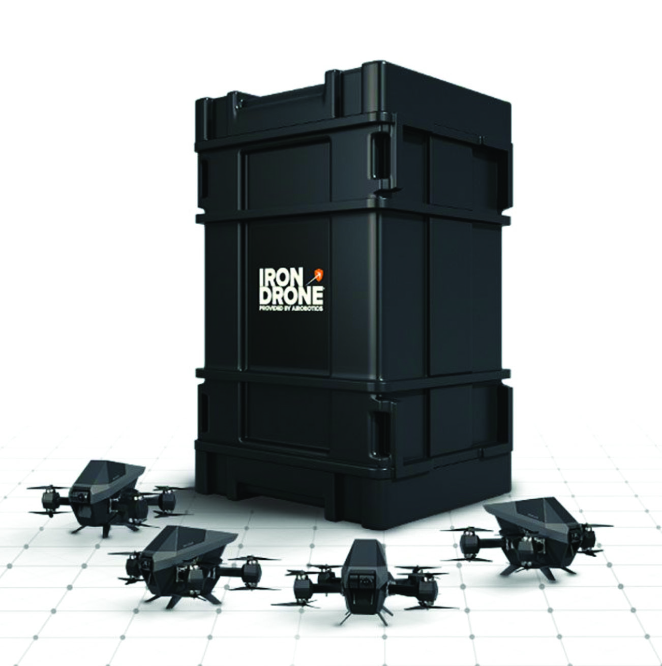
Image: Airobotics
C-UAV Device Anti-UAV protection device
The Iron Drone system is an advanced counter-UAV device, designed to defend against hostile drones in complex environments with minimal damage. Iron Drone is an automated intercepting system designed to eliminate small drones without using GPS or radio frequency jamming. The Iron Drone system is launched from a designated pod and flies autonomously towards targets under radar guidance. It identifies the target using computer vision capabilities. The intercepting UAV follows the target then uses a net and a parachute to incapacitate it, capture it and lower it to the ground.
Airobotics, airoboticsdrones.com
Image: Rohde & Schwarz
Drone-based analyzer For UAV inspections
EVSD1000 VHF/UHF nav/drone analyzer provides highly accurate UAV inspection of terrestrial navigation and communications systems. The EVSD1000 VHF/UHF nav/drone analyzer is a signal-level and modulation analyzer for medium-sized UAVs. It features measurements of instrument landing systems, ground-based augmentation systems and VHF omnirange ground stations. The mechanical and electrical design is optimized for UAV-based, real-time measurements of terrestrial navigation systems with up to 100 measurement data sets per second. The analyzer provides high-precision signal analysis in the frequency range from 70 MHz to 410 MHz. This also includes the needed measurement repeatability to ensure that results from UAV measurements can be compared to flight and to ground inspections in line with ICAO standards. The EVSD1000 VHF/UHF nav/drone analyzer reduces runway blocking times, provides necessary measurement repeatability and offers measurement precision and GNSS time and location stamps. While streaming measurement data during a drone flight via the data link to a PC on the ground, the analyzer can also buffer data internally to ensure no results are lost if the data link is lost. Rohde & Schwarz, rohde-schwarz.com
SURVEYING & MAPPING
Image: SiLC
Coherent Vision Solution Suitable for advanced products
The Eyeonic Vision System is a frequency-modulated continuous wave lidar solution, which delivers high levels of vision perception to identify and avoid objects with low latency. At the core of the system is a fully integrated silicon photonics chip. It provides more definition and precision than legacy lidar solutions, with roughly 10 milli-degree of angular resolution coupled with millimeter-level precision. These features enable this solution to measure the shape and distance of objects with high-precision and at a large distance. The system combines the Eyeonic Vision Sensor and a digital processing solution based on a powerful field-programmable gate array. The flexible architecture enables synchronization of multiple vision sensors for unlimited points per second. The compact, powerful, vision solution is suitable for autonomous vehicles, smart cameras, robotics and other advanced products. It is available now. Pricing varies depending on configuration.
SiLC Technologies, silc.com
Image: SBG Systems
GNSS-Aided INS Easily integrated with lidar or other third-party sensors
Quanta Plus is a GNSS-aided inertial navigation system (INS). The device combines a MEMS inertial measurement unit (IMU) with a resilient GNSS receiver to get reliable position and attitude, as well as providing real-time kinematic (RTK) fixes. Quanta Plus includes motion profiles, which enable users to optimize the sensor parameters to suit different use cases. The built-in precise time protocol server ensures sub-microsecond synchronization with external devices such as lidar. The device also has a built-in datalogger, Ethernet interface for easy integration, and a web configuration interface for simple setup and control. The INS can be integrated with Qinertia, SBG System’s post-processing software. Qinertia improves the performance of acquired data during a mission using reliable RTK corrections from a wide range of continuously operating reference station networks, or by importing base-station data during the process. Quanta Plus also improves the accuracy of the position and attitude using forward and backward processing and by integrating a tight coupling between GNSS and IMU data. SBG Systems, sbg-systems.com
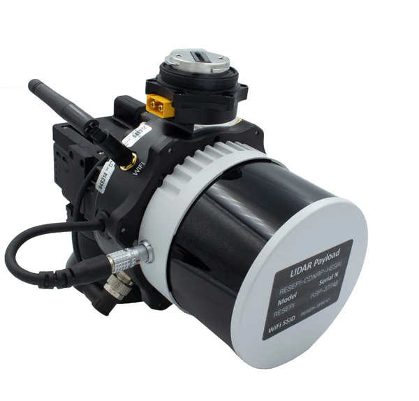
Image: Inertial Labs
Survey Laser Suitable for remote-sensing applications
The Resepi Hesai XT32 laser is designed for accurate remote-sensing applications. It can be used with commercially available lidar scanners, including Velodyne, Quanergy, Ouster, RIEGL, LIVOX and Hesai, as well as with UAVs. Resepi is completely modular, so users have full control for customization. The remote-sensing device uses a GPS-aided inertial navigation system with a NovAtel RTK/PPK single- or dual-antenna GNSS receiver, integrated with a Linux-based processing platform. It also comes with a 2 TB USB memory drive and has an embedded Wi-Fi cellular modem. Resepi has 3 cm to 5 cm point-cloud accuracy and can reach heights of more than 200 m above ground level. It is compatible with most UAV models; however, it is typically used with DJI M300, DJI M210 or DJI M600 models. The device is suitable for scanning and mapping, precision agriculture with lidar, simultaneous localization and mapping algorithm development, utility inspection and construction site monitoring. Resepi-supported software includes Hexagon NovAtel, PCPainter and PCMaster. Inertial Labs, inertiallabs.com
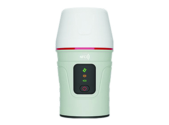
Image: CHC Navigation
IMU-RTK GNSS Receiver Provides robust and accurate positioning
The i90 GNSS receiver combines a GNSS real-time kinematic (RTK) engine, a high-end inertial measurement unit (IMU) sensor and advanced GNSS tracking capabilities to increase RTK availability and reliability. The embedded 624-channel GNSS receiver is compatible with GPS, GLONASS, Galileo and BeiDou signals. The i90 GNSS combines high-end connectivity modules: Bluetooth, Wi-Fi, NFC, 4G and a UHF radio modem. The internal UHF radio modem allows long-distance base-to-rover surveying up to 5 km. The built-in IMU ensures interference-free and automatic pole-tilt compensation in real time. An accuracy of 3 cm is achieved with pole-tilt range of up to 30°. The i90 GNSS receiver is suitable for construction and land surveying projects. CHC Navigation, chcnav.com
Image: CHCNAV
Field Application For Android devices
LandStar8 is designed to be flexible and user-friendly for surveying and mapping tasks. It is versatile, modular and customizable for topographic tasks such as surveying, stake out, cadastral, mapping and geographic information systems (GIS). Building on the legacy of LandStar7, the LandStar8 provides features such as a refined user interface, streamlined workflows, faster operation, and integrated cloud services. Cloud connectivity is built in for backup, data storage or remote technical support. LandStar8 has a simple and intuitive layout with large map windows and sharp graphics. Users can hide features they rarely use and display only those they need. They also can copy coordinate settings, control and staking points from another handheld controller by scanning a QR code. Projects can be edited and sorted by history and attributes. Custom coordinate systems, geoid models and coding libraries can be updated at any time by using resource packages. LandStar8 also features a terrain calibration wizard designed for non-expert users. CHCNAV, chcnav.com
Image: Position Partners
Survey Rover For accurate, survey-grade aerial mapping and photogrammetry
SmartSurveyor facilitates accurate, survey-grade aerial mapping and photogrammetry without the need for a connection between a camera shutter and a GNSS receiver. The fully compact, handheld aerial mapping survey rover is compatible with DJI Mavix 2 and 3 series and Phantom 4 Pro UAVs. The design is dissimilar from other UAV mapping systems in that it works from a UAV or smartphone and with two or more ground control points (GCPs) while using an ultra-matching technique. Once SmartSurveyor captures data, all photos and the GNSS file are uploaded to a PC and analyzed through the Agisoft UltraMatch workflow to confirm their accuracy before they are exported. Data can be managed in the cloud or on a local PC using software designed by MapSender. Additionally, this mapping tool works in tandem with the AllDayRTK subscription GNSS network service so that collected data can be uploaded to Tokara to remotely manage a project.
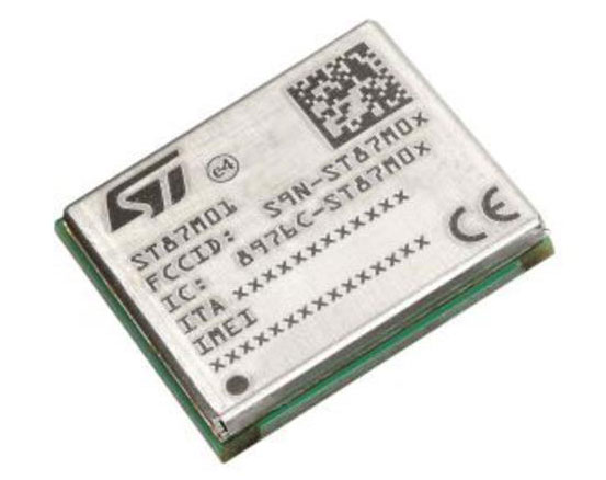
NB-IoT Industrial Module Complete with GNSS geo-location capabilities
Image: STMicroelectronics
The ST87M01 is a fully programmable, certified LTE Cat NB2 NB-IoT industrial module that covers worldwide cellular frequency bands and integrates advanced security features. The ST87M01 is an integrated native GNSS receiver with multi-constellation access, which ensures enhanced and accurate localization. The module has a diminutive 10.6 mm x 12.8 mm land grid array footprint, making it suitable for applications where a small form factor is key. The STM8701 offers flexibility for product developers, presenting a fully programmable internet of things (IoT) platform enabling users to embed their own code into the module for simple applications. A variety of protocol stacks are available to handle popular IoT use cases. It targets wide-ranging IoT applications that require ultra-reliable low-power wide-area network connectivity and has ultra-low power consumption with less than 2 µA in low-power mode and transmit output power up to +23 dBm. Suitable applications for the module include smart metering, smart grid, smart building, smart city and smart infrastructure applications, as well as industrial condition monitoring and factory automation, smart agriculture and environmental monitoring. The module also can be combined with a separate host microcontroller, permitting many more use cases. STMicroelectronics, st.com
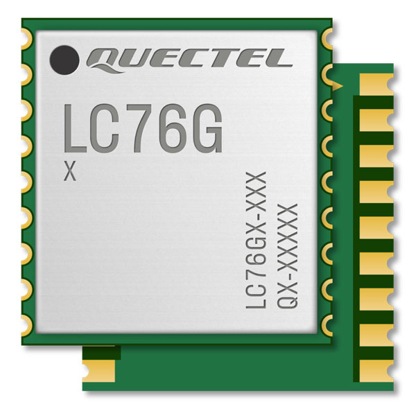
Image: Quectel
GNSS Module Designed for battery-operated, ultra-low power GNSS devices
The LC76G module is a compact, single-band, ultra-low power GNSS module that features fast and accurate location performance. The module can concurrently receive and process signals from the GPS, GLONASS, BeiDou, Galileo and QZSS constellations. The LC76G has an internal surface acoustic wave filter and integrated low-noise amplifier, which can be connected directly to a passive patch antenna and provides filtering against unwanted interference. With a compact size of 10.1 mm × 9.7 mm × 2.4 mm, the footprint of the LC76G is compatible with other industry solutions, as well as Quectel’s legacy L76 and L76-LB modules. The LC67G is designed for battery-operated, ultra-low power GNSS devices, such as wearable personal trackers, wildlife and livestock tracking, toll tags, portable container trackers, as well as several traditional markets such as shared mobility and low-cost asset trackers. Quectel Wireless Solutions, quectel.com
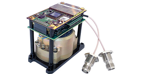
The INS-DH-OEM. (Photo: Inertial Labs)
Inertial Navigation System Incorporates NovAtel and Honeywell technology
The INS-DH-OEM utilizes a dual-antenna NovAtel GNSS receiver and a Honeywell HG4930-CA51 inertial measurement unit (IMU). The INS-DH-OEM contains Inertial Labs’ on-board sensor-fusion filter, navigation and guidance algorithms, and calibration software. The INS-DH-OEM has three axes, a full operational temperature range, advanced MEMS accelerometers and new-generation tactical-grade MEMS gyroscopes to provide accurate position, velocity, heading, pitch and roll. It is small and lightweight, measuring 85.5 mm x 67.5 mm x 52.0 mm and weighing 280 g. The dual-antenna NovAtel GNSS receiver is operational with GPS, GLONASS, Galileo, BeiDou and QZSS constellations. The INS-DH-OEM is compatible with most commercially available lidars including Velodyne, Riegl and Faro. The algorithms are suitable for different dynamic motions of vessels, ships, helicopters, UAVs, gimbals and land vehicles. Inertial Labs, inertiallabs.com
Image: MSO
Speed Sensor Multi-use sensor for workflow
The Speed Wedge MKII is a true-ground speed sensor and active motion detector for moving objects, based on radar doppler technology. This sensor is suitable for use in indoor and off-highway vehicles, conveyor belts, material flow and open channel water surface flow. The sensor contains a dead-reckoning system component for inertial measurement units and integrated management systems (IMS) in GPS/GNSS-denied environments such as in tunnels and underground mining operations. It also features sensor fusion with GNSS and IMS improving positioning accuracy, quality and reliability. Speed Wedge MKII deploys a radar front-end with planar antennas continuously emitting electro-magnetic waves at 24 GHz. It is designed for contactless measurement of speed and distance travelled independent on wheel/drive slip. For demanding applications Speed Wedge MKII is sealed and potted in a rugged encasing. Speed Wedge MKII is available in variants with pulse, serial RS232 and CAN-Bus output. High-speed up to 200 km/h is available.
MSO, mso-technik.de/home-en.html
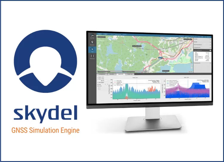
Image: Orolia
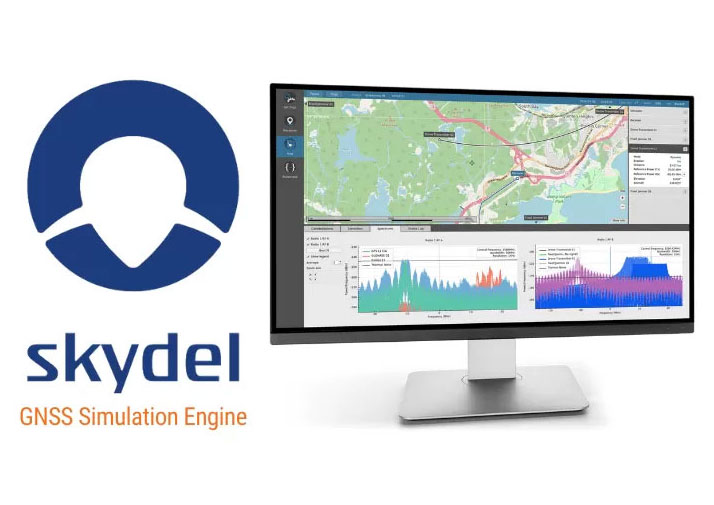
GNSS Simulations Software For simulation and testing needs
Skydel GNSS simulation software can now generate more than 500 simulated satellite signals. This platform is suitable for GNSS users, experts and manufacturers, as well as users needing a low-Earth-orbit-capable simulation system. Skydel contains a feature that includes multi-constellation and multi-frequency signal generation, remote control from user-defined scripts, and integrated interference generation. In addition to generating a high channel and satellite count, Skydel also can produce navigation warfare signals without any additional hardware. Orolia, orolia.com
Image: Mikroe
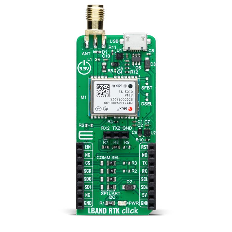
Compact Add-On Board Provides access to L-band GNSS corrections
LBand RTK Click is a compact add-on featuring the NEO-D9S-00B, a professional-grade, satellite data receiver for L-band corrections from u-blox. Operating in a frequency range from 1,525 MHz to 1,559 MHz, the NEO-D9S-00B decodes the satellite transmission and outputs a correction stream. This enables a high-precision GNSS receiver to reach accuracies down to centimeter-level. An independent stream of correction data, delivered over L-band signals, ensures high availability of position output. LBand RTK Click also uses several mikroBUS pins. In addition, LBand RTK Click contains an SMA antenna for connecting a Mikroe-brand antenna. This antenna easily allows positioning in space, supporting GNSS L-band frequencies. LBand RTK Click implements advanced security features such as signature and anti-jamming mechanisms. It also can be integrated with other GNSS receivers from the u-blox F9 platform. Mikroe, mikroe.com
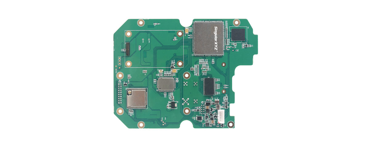
SingularXYZ, a manufacturer of GNSS technology, has launched its DK100 development kit. This multi-functional kit has selectable single-antenna and dual-antenna modules, full constellation tracking and centimeter-level positioning.
The DK100 development kit is a ready-to-use kit designed to simplify integration efforts and increase compatibility with a variety of applications. The kit reserves standard adapter board interfaces to connect different GNSS modules and radio modules for a variety of needs.
The development kit features a 4G module, Wi-Fi, Bluetooth, and Ethernet modules as well as status indicators on a single PCBA.
The DK100 development kit comes with its own web page for configuration. With Ethernet and Wi-Fi access, users can monitor device status and configure working mode and data transmission settings on the page.
The centimeter-level DK100 kit can be integrated in a range of horizontal and vertical applications, such as construction using CORS networks, precision agriculture, construction machinery, smart navigation, monitoring, robotics, unmanned systems and more.
A roundup of recent products in the GNSS and inertial positioning industry from the March 2023 issue of GPS World magazine.
UAV
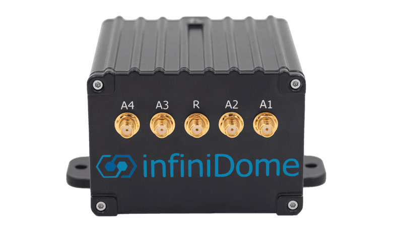
Image: InfiniDome
Anti-Jamming Device Provides protection from three directions of attack
The GPSdome 2 is tailored to defend small- to medium-sized tactical UAVs as well as manned and unmanned ground vehicles. With a small form factor (500 g, 87 mm x 91 mm x 61.55 mm) and minimal power consumption, GPSdome 2 is suitable for loitering munitions as well as UAVs. Fully retrofit and completely standalone, the system is compatible with almost any off-the-shelf GNSS receiver as well as standard active GNSS antennas, meaning that it can be integrated into existing GPS systems or into new product lines, manned or unmanned. With sophisticated algorithms and a proprietary RFIC, GPSdome 2 analyzes RF interference in the environment and combines multiple antenna patterns to create and dynamically steer three nulls in the direction of any hostile signal. GPSdome 2 provides simultaneous dual-frequency protection (GPS L1 + L2 or GPS L1 + GLONASS G1), creating up to three nulls, protecting from three jamming directions within each band in real time, making it suitable for PNT applications. The GPSdome 2 is a dual-use, non-ITAR device and comes with optional mil-spec compliance. InfiniDome, infinidome.com
Image: uAvionix
Command and Control Designed for easy integration
The SkyLine C2 management platform and muLTElink airborne radio systems (ARS) are designed to integrate, which enables a self-healing command-and-control network capable of both path and link diversity. This eliminates lost-link possibilities over broad terrain and altitude ranges. MuLTElink ARS consists of two models — muLTElink915 and muLTElink5060, the core of the uAvionix C2 system. The muLTElink915 model combines globally licensed aviation LTE, enhanced with frequency hopping 902 MHz – 928 MHz industrial, scientific and medical frequencies capability. The muLTElink5060 model combines global LTE with aviation-protected 5,030 MHz – 5,091 MHz C-band. Each muLTElink model allows up to one external CNPC radio to be optionally connected to allow simultaneous use of all three frequency ranges, higher power C-band operation or future radio integrations. uAvionix, uAvionix.com
Image: Atmos
VTOL UAV With Sony a7R mark III and IV camera
Atmos has integrated the Sony a7R mark III and IV cameras into its vertical take-off and landing (VTOL) fixed-wing UAV, the Marlyn Cobalt. This will increase coverage and accuracy achieved in a single flight for surveyors. Both cameras have an ISO of 32,000, which is expandable to 102,400, and camera sensors with high megapixel count — 42,4 MP for the a7R III and 61 MP for the a7R IV. When combined with Zeiss’ 35 mm and 21 mm lenses, it enables UAV surveyors to achieve ground sample distance levels below one 1 cm. The integration of the two cameras enables Marlyn Cobalt users to map an area of 210 ha with centimeter-level accuracy in a single flight. Atmos, atmosuav.com
UAV and Lidar Systems Suitable for geospatial professionals
TrueView 535 consists of updated lidar sensors, adding a third return, increasing mapping abilities below canopy. An additional third nadir camera offers another point of view and improves photogrammetry quality. It also includes a longer, usable lidar range to increase flexibility. TrueView 720 is a fourth-generation Riegl VUX-120 with three laser beam orientations. It provides high-point density corridor mapping. Using the Riegl VUX-120 with three laser beam orientations (nadir, +10 degrees forward and –10 degrees backward) and three oblique/nadir cameras enables data collection from more surfaces in one flight path. One application of TrueView 720 is scanning power lines. Users can capture the poles vertically, front and back. The extreme range of this system means it can be integrated with UAVs, airplanes or helicopters. In addition to the two sensor payloads, GeoCue has launched its LP360 software add-on for processing and visualization — the 3D Accuracy and the Accuracy Star hardware.
GeoCue, geocue.com
OEM
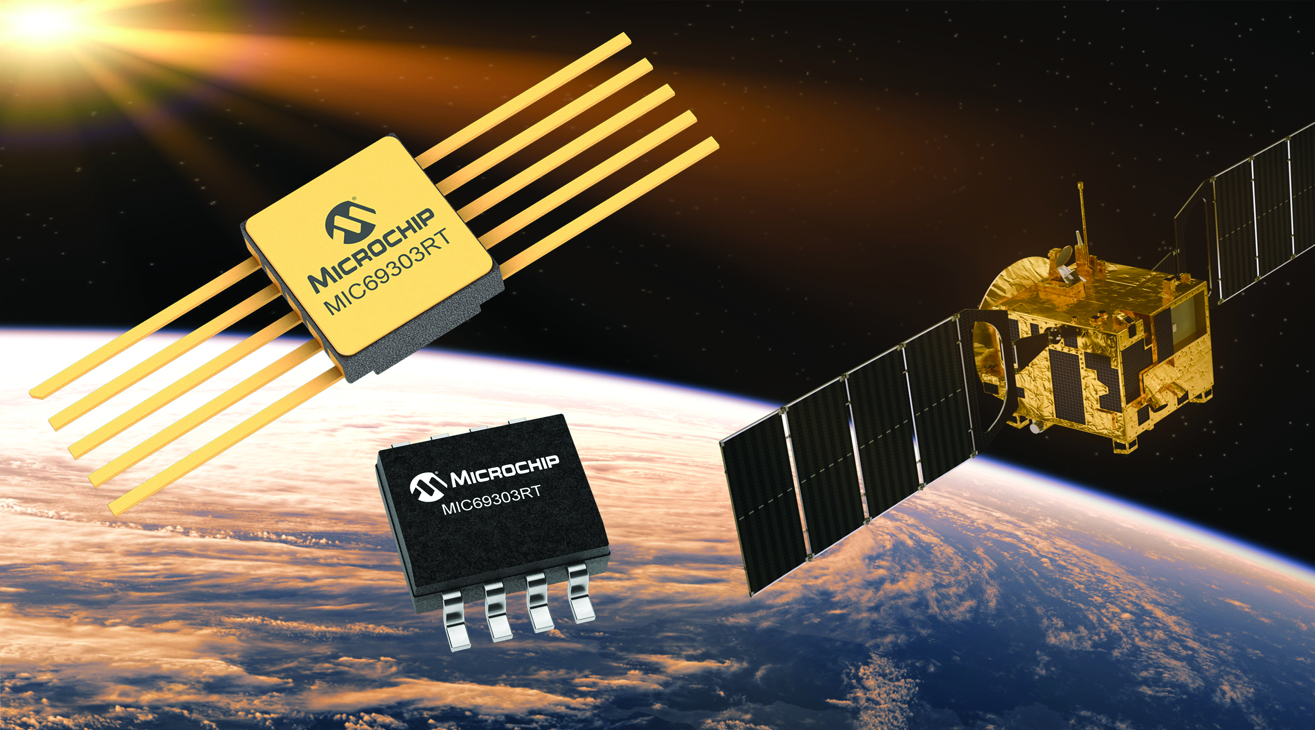
Image: Microchip
Voltage Regulator Device for LEO space application
The MIC69303RT is a radiation-tolerant power management device for space application developers. It is a high-current, low-voltage device targeting low-Earth orbit space applications. The MIC69303RT operates from a single low-voltage supply of 1.65 v to 5.5 v and can supply output voltages as low as 0.5 v at high currents. It offers high-precision and low dropout voltages of 500 mv under extreme conditions. The MIC69303RT is a companion power source solution for microcontrollers, such as the SAM71Q21RT and PolarFire field-programmable gate arrays. MIC69303RT is designed for harsh aerospace applications and remains operational in temperature ranges from -55 C to +125 C. Microchip Technology, microchip.com
Image: Spirent Communications
LEO Satellite Device Designed for GNSS/PNT lab testing
SimORBIT is a low-Earth-orbit (LEO) satellite solution software designed to aid developers in determining LEO orbits more accurately for GNSS/PNT lab testing. The software replicates LEO orbits so that simulations can provide the realistic environment of a LEO satellite, including gravitational and atmospheric impacts the satellite could encounter in space. Developers can create non-ICD signals via I/Q injection, or by the “Flex” feature, generating space-centered PNT signals to be developed in the lab as realistically as possible. Spirent Communications developed SimORBIT in partnership with SpacePNT. Spirent Communications, spirent.com
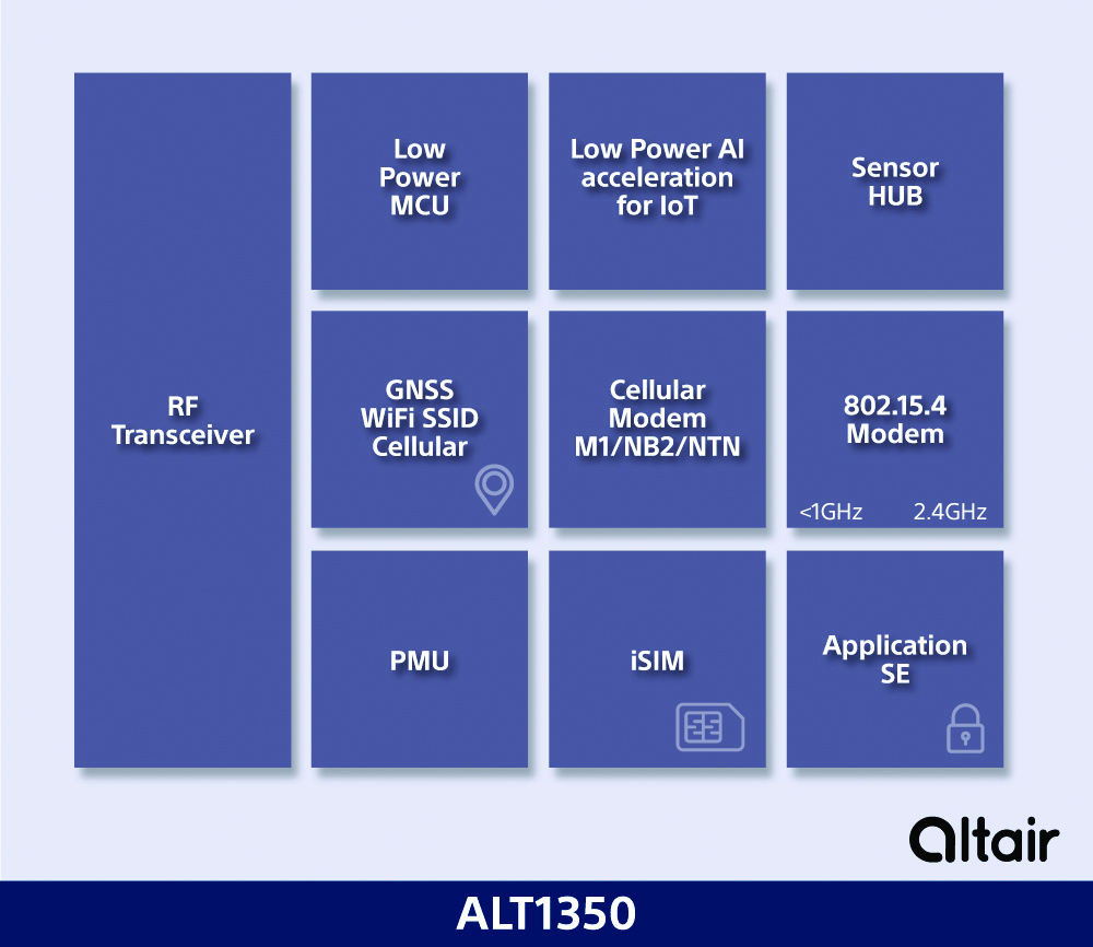
Image: Sony
5G Chipset Includes GNSS
The ALT1350 implements GNSS, cellular and Wi-Fi-based location in a single chipset. The cellular LTE-M/NB-IoT chipset is designed to enable additional low-power, wide-area (LPWA) communication protocols; intermittent LTE and GNSS (GPS/GLONASS) navigation for low-cost applications; and concurrent LTE and L1/L5 GNSS for tracking applications. The ALT1350 incorporates a sensor hub to collect data from the sensors while maintaining ultra-low power consumption. It also provides cellular and Wi-Fi-based positioning and is tightly integrated to provide power-optimized concurrent LTE and GNSS to accommodate various tracking applications, which can be demanding with a single chip. The chip is designed to enable deployments for the internet of things (IoT), including location technologies. Sony, altair.sony-semicon.com
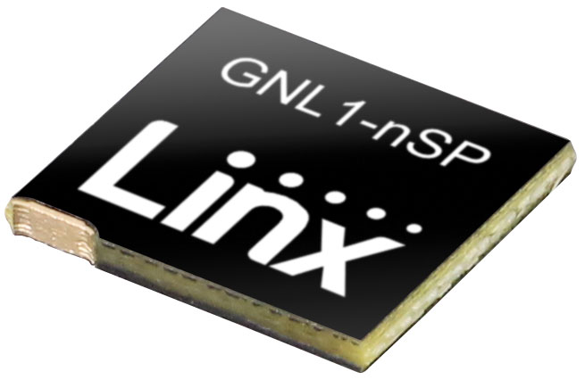
The ANT-GNL1-nSP is a surface-mount embedded GNSS antenna supporting GPS, Galileo, GLONASS, BeiDou and QZSS in the L1/E1/B1 bands. The ANT-GNL1-nSP antenna exhibits high performance in a compact size (10 mm x 8 mm x 1 mm) and features linear polarization and an omnidirectional radiation pattern. The antenna is available in tape and reel packaging and is designed for reflow-solder mounting directly to a printed circuit board for high-volume applications. Linx Technologies, linxtechnologies.com
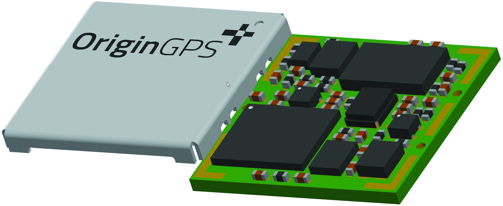
Image: OriginGPS
GNSS Module Based on a MediaTek chipset
The ORG4600-MK01 dual-frequency module provides higher precision than the company’s previous modules. It has sub-1 m precision at a cost lower than that of the company’s first L1+L5 module, the ORG4600-B01, which is based on Broadcom’s chipset. The 10 mm x 10 mm ORG4600-MK01 was designed for applications deployed in challenging environmental conditions. The solution also includes RTCM, a logger and accurate orbit prediction. OriginGPS, origingps.com
MAPPING
Image: Mapbox
Navigation Software Includes enhancements to existing software and more
Navigation software development kit version 2.9 provides pre-built applications compatible with Android and IOS. SDK v2.9 provides the primary navigation components across a workflow using lines of code instead of starting from square one. The drop-in user interface is customizable to reflect a developer’s brand, obviating the need to manually develop a full end-to-end application. Navigation SDK Copilot — a backend analytics tool for CX on navigation applications — collects trace files of navigation sessions and search analytics data from users. Developers can use this data to gather feedback and collective user data to create touch points with users and improve application experience based on their data-drawn conclusions. Matrix API has been updated to support scheduled departure times and provide optimal driving routes, creating a more accurate estimated time of arrival. Mapbox, mapbox.com
Image: Hexagon
Defense Platform For developing Android applications
LuciadCPillar is designed for the development of mobile applications for dismounted soldiers in the field. Developers can build applications with 2D and 3D views. It features military symbology and supports many geospatial data types including vector data, raster data, elevation data, point clouds and 3D meshes. It has the same capabilities found in desktops, in-vehicle and browser applications built with LuciadLightspeed, LuciadCPillar and LuciadRIA. The platform offers capabilities to match high-resolution screens, graphic processing units and multi-core processors including the ability to display 3D data in mobile applications. LuciadCPillar supports ARM processors and an application programming interface, which aligns with the Android developer experience. Impact, a French system integrator, partnered with Hexagon to test LuciadCPillar and will integrate it into its Delta Suite product, which is used by the French Special Operations Command. LuciadCPillar is part of Luciad 2022.1, which is available now globally. Hexagon, hexagon.com
Image: Golden Software
Surface Mapping Designed for 3D surface mapping
The Surfer package is designed for 3D surface mapping and provides robust subsurface visualization and modeling functionality by incorporating many true 3D gridding and visualization tools. With the enhanced functionality, users can now model an additional variable, a C variable, such as a contaminant or chemical concentration, along with the traditional X, Y, Z values. Surfer also includes the ability to create a 2D map of a slice-through 3D grid, which users can move up and down through the grid, illustrating how the C value changes with depth. Part of Surfer’s enhancements is isosurface creation, enabling visualization of the 3D grid in the 3D view as an isosurface, providing another way to see how C data varies with depth or elevation. The new 3D-rendered volume functionality also allows users to visualize the 3D grid in the 3D view as a solid body by assigning colors to different C values, highlighting variations in the data. Golden Software, goldensoftware.com
Orolia’s Skydel, its GNSS simulation software, can now generate more than 500 simulated satellite signals. This platform is suitable for GNSS users, experts and manufacturers, as well as users needing a low-Earth-orbit-capable simulation system.
Skydel contains a feature that includes multi-constellation and multi-frequency signal generation, remote control from user-defined scripts, and integrated interference generation.
“With more and more customers simulating multipath and jamming scenarios, and the need for more signals in more applications — even beyond traditional simulators — the need for high capacity has never been greater,” said Pierre-Marie Le Veel, Orolia’s simulation product director. “The Skydel engine opens the possibility for users to escalate to more than 1,000 signals and not be limited by hardware design.”
In addition to generating a high channel and satellite count, Skydel can also produce navigation warfare signals without any additional hardware.
LBand RTK Click is a compact add-on board that provides access to L-band GNSS corrections. The board features the NEO-D9S-00B, a professional-grade, satellite data receiver for L-band corrections from u-blox.
Operating in a frequency range from 1,525 MHz to 1,559 MHz, the NEO-D9S-00B decodes the satellite transmission and outputs a correction stream. This enables a high-precision GNSS receiver to reach accuracies down to centimeter-level. An independent stream of correction data, delivered over L-band signals, ensures high availability of position output.
LBand RTK Click also uses several mikroBUS pins. The EIN pin routed to the AN pin of the mikroBUS socket is used as an external interrupt feature activated through a population of the R6 0Ω resistor.
In addition, LBand RTK Click contains an SMA antenna for connecting a Mikroe-brand antenna. This antenna easily allows positioning in space, supporting GNSS L-band frequencies.
LBand RTK Click implements advanced security features such as signature and anti-jamming mechanisms. It can also be integrated with other GNSS receivers from the u-blox F9 platform.
A roundup of recent products in the GNSS and inertial positioning industry from the February 2023 issue of GPS World magazine.
SURVEYING & MAPPING
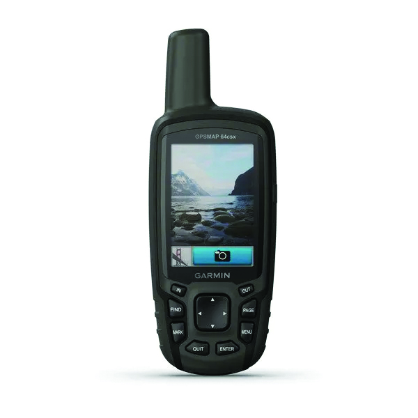
GPSMAP 64csx handheld GPS receiver (Image: Gamin)
Handheld GPS With navigation sensors and camera
The GPSMAP 64csx handheld GPS receiver comes with multi-GNSS support, TopoActive mapping, barometric altimeter, three-axis compass, and wireless connectivity via Bluetooth and ANT+ technology. It also has an 8 MP autofocus camera. The GPSMAP 64csx is built to withstand rugged terrain and is water-resistant. The highly sensitive receiver and quad helix antenna provide support from GPS, GLONASS and Galileo. Preloaded TopoActive maps include waterways, natural features, buildings and international boundaries. It is compatible with smartphones so users can receive email and text messages and share location data with others. Garmin, garmin.com
The Venus Laser RTK receiver comes with an inertial measurement unit. It can be used in its traditional mode with a range pole, or in laser mode without a pole, enabling GNSS surveying beyond typical limitations. In traditional mode, it has tilt compensation of up to 60° with an accuracy of 2.5 cm; in laser mode, it has the same tilt compensation but an accuracy of 5.5 cm. The receiver is powered by a SinoGNSS K8 high-precision module capable of up to 1,590 channels. It can survey using GPS, BDS-2, BDS-3, GLONASS, Galileo, QZSS and SBAS constellations. Other features include Bluetooth connectivity, more than 20 hours of battery life, and ruggedness (it is dust and waterproof and is designed to survive a two-meter drop). ComNav Technology Ltd., comnavtech.com
Leica iCON gps 160 (Image: Leica Geosystems)
Smart Antenna With features to increase productivity on the construction site
The Leica iCON gps 160 is a next-generation construction smart antenna designed to increase productivity in stakeout and measurement applications on the jobsite. It features a large color display with clear navigation for quick and easy setup without additional hardware. It is optionally available with an inertial measurement unit (IMU) for tilt-compensation functionality up to 20°. It seamlessly integrates with all Leica iCON construction instruments and controllers as well as the iCON field software for precise, real-time verification. Leica Geosystems, leica-geosystems.com
The Xsens Vision Navigator (Image: Movella)
GNSS inertial navigation Integrates position inputs from three high-accuracy sources
The Xsens Vision Navigator integrates position inputs from three high-accuracy sources including dual-antenna real-time kinematic (RTK) GNSS receivers; an inertial measurement unit (IMU) incorporating a three-axis accelerometer, a gyroscope and magnetometer; and a visual inertial odometry system. It can optionally accept input from an external wheel-speed sensor. The positioning sensor achieves centimeter-level accuracy when operating in GNSS mode with an RTK fix. When GNSS signals are not available, the product alone achieves accuracy of 2% of travel distance, or 0.75% when supplemented by wheel speed. Xsens Vision Navigator is suitable for outdoor positioning applications such as material handling equipment, commercial and specialist vehicles, last-mile delivery, inspection equipment and UAVs, agricultural equipment, mining equipment and utility robots. Movella, movella.com
SILC Eyeonic Vision System (Image: SiLC)
Coherent Vision Solution Delivers high levels of vision perception
The Eyeonic Vision System is a frequency-modulated continuous wave lidar solution, which delivers high levels of vision perception to identify and avoid objects with low latency. At the core of the Eyeonic Vision System is a fully integrated silicon photonics chip. It provides more definition and precision than legacy lidar solutions, with roughly 10 milli-degree of angular resolution coupled with millimeter-level precision. These features enable this solution to measure the shape and distance of objects with high-precision and at a large distance. The system combines the Eyeonic Vision Sensor and a digital processing solution based on a powerful field-programmable gate array. The flexible architecture enables synchronization of multiple vision sensors for unlimited points per second.
SiLC, silc.com
OEM
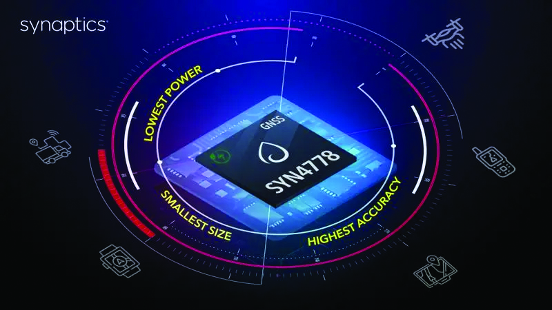
The SYN4778 (Image: Synaptics)
Integrated Circuit Designed for the internet of things
The SYN4778 is a small, low-power GNSS integrated circuit designed to extend battery life, reduce product size, and enhance performance of advanced location-based services for internet of things (IoT) devices — wearables, mobile accessories, asset trackers, UAVS and transportation devices. It includes advanced multipath interference mitigation using L5-band signals from GPS, Galileo, BeiDou, NAVIC, SBAS and QZSS. The chip also uses the L1 satellite band to reduce both the time to first fix, and the power consumed, improving the end-user experience and enabling product developers to add additional functionality and features to their IoT devices. Synaptics, synpatics.com
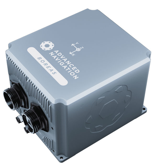
The Boreas D70 is a fiber-optic gyroscope (FOG) inertial navigation system (INS), part of the Boreas digital FOG series. The technology is suited to surveying, mapping and navigation across subsea, marine, land and air applications. It also could be adopted for vehicular applications, including autonomous vehicles and aircraft where weight and size are at a premium. The Boreas D70 combines closed-loop DFOG and accelerometer technologies with a dual-antenna real-time kinematic (RTK) GNSS receiver. These are coupled with an artificial-intelligence-based fusion algorithm to deliver accurate and precise navigation. Advanced Navigation, advancednavigation.com
The u-blox NEO-F10T (Image: u-blox)
Timing Module Dual-band and secure for 5G communications
The u-blox NEO-F10T offers nanosecond-level timing accuracy, meeting the stringent timing requirements for 5G communications. It is compliant with the u-blox NEO form factor (12.2 mm x 16 mm), allowing space-constrained designs to be realized without the need to compromise on size. The NEO-F10T is the successor to the NEO-M8T module, providing an easy upgrade path to dual-band timing technology. This allows NEO-M8T users to access nanosecond-level timing accuracy and enhanced security. u-blox’s dual-band technology mitigates ionospheric errors and greatly reduces timing error, without the need for an external GNSS correction service. u-blox, u-blox.com
TRANSPORTATION
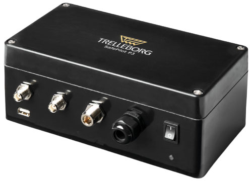
SafePilot P3 (Image: Trelleborg)
Maritime Systems Provides data on vessel positioning
The SafePilot P3 navigation system provides real-time data on vessel positioning and movement in tight waterways. It uses motion sensors and two GNSS antennas to measure the position and heading of vessels in three dimensions, minimizing time and difficulty associated with piloting procedures. SafePilot P3 has a backup battery to maintain functionality in the event of a power outage. This navigation system improves situational awareness while navigating waterways and ports globally, and also enhances communication between the captain, pilot, tug operators and canal personnel while vessels are transiting a canal and approaching a port.
Trelleborg, trelleborg.com
FusionEngine software (Image: Point One Navigation)
Positioning Engine Assures functional safety of ASIL-B
FusionEngine software, which is rated for automotive safety integrity level (ASIL), is now compatible with STMicroelectronics’ Teseo ASIL Precise Positioning GNSS chipset TeseoAPP. This assures functional safety of ASIL-B, a requirement for Level 3+ advanced driver assistance systems (ADAS). It can be integrated into several different host processors to enable high-level ADAS and autonomous driving systems. The combination of TeseoAPP’s receiver and the STA5365S external RF front-end provides dual-band measurement data for all visible GNSS satellites to the main host processor into which
FusionEngine is integrated. Point One Navigation, pointonenav.com
Ghost Autonomy Engine (Image: Ghost)
Autonomous driving software for level 4 driver assistance
The Ghost Autonomy Engine achieves the reliability required to bridge the gap between driver assistance capabilities L2 or L2+, and self-driving that does not rely on a human backup (L4). The software provides a stereo-vision neural network that delivers per-pixel depth in real time. It is capable of detecting and segmenting key features in a scene without needing to classify or recognize them. The physics-based perception system can handle the long tail of obstacles on the road, even those never seen before. Ghost, ghostautonomy.com
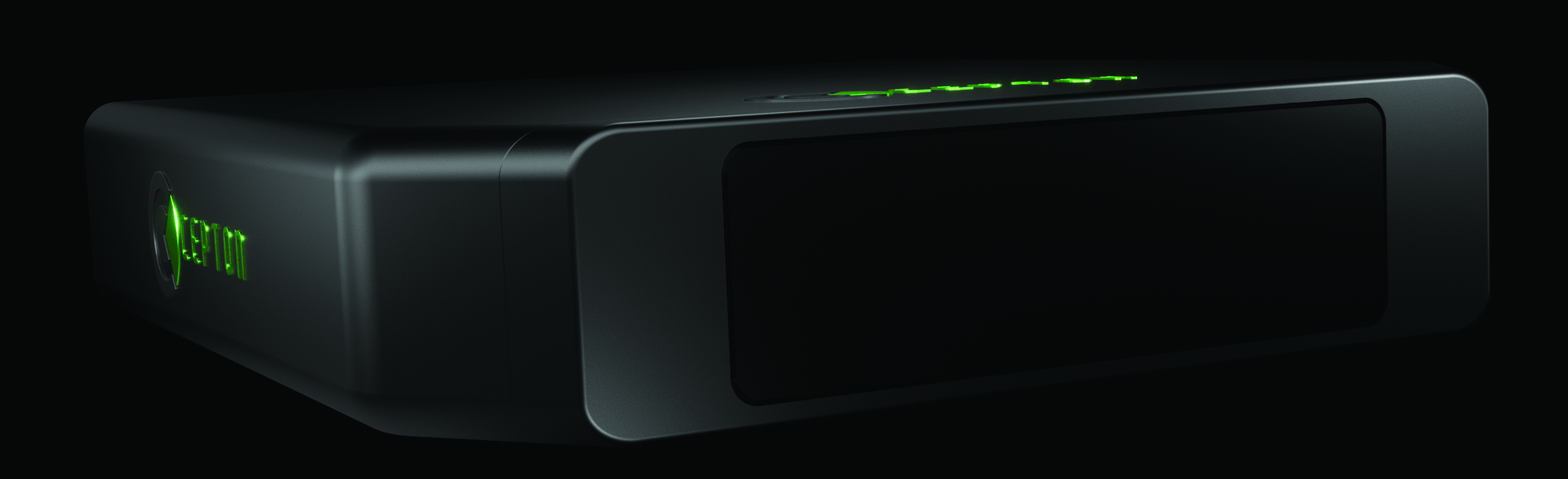
Vista-X120 Plus (Image: Cepton)
Lidar Provides 3D perception
The Vista-X120 Plus is a slim automotive lidar device for real-time adaptive 3D perception for advanced driver assistance. Its software-definable region of interest enables higher dynamic perception capabilities, while an adjustable central field of view with increased angular resolution improves accuracy in detection and classification of objects when driving. The region of interest is also configurable in real time in both horizontal and vertical directions. The Vista-X120 Plus is compact at 140 mm x 30 mm, improving OEM integration and placement options without disrupting vehicle appearance. Cepton, cepton.com
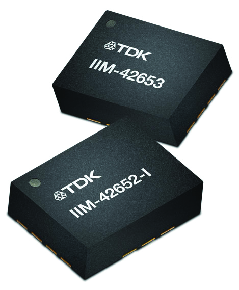
IIM-42653 and IIM-42652-I sensor platforms (Image: TDK Corporation)
Sensor Platforms Targets industrial and navigation applications
The IIM-42653 and IIM-42652-I sensor platforms consist of 6-axis IMUs, which target industrial and navigation applications requiring high force sensitive resistor (FSR) performance or inertial navigation software. The IIM-42653 platform — a robust, low-noise, low-power, 6-axis IMU — is capable of a gyro-programmable output of 4,000 dps and an accelerometer-programmable output of 32 g. These features make the IIM-42653 suitable for industrial-grade or high-end automated guided vehicles, automated mobile robots and unmanned aerial vehicles. The IIM-42652-I platform offers hardware authentication and can be integrated with TRACK dead-reckoning software from Trusted Positioning. TRACK filters GNSS multipath errors and provides a continuous navigation solution when GNSS signals are unavailable. TDK Corporation, invensense.tdk.com
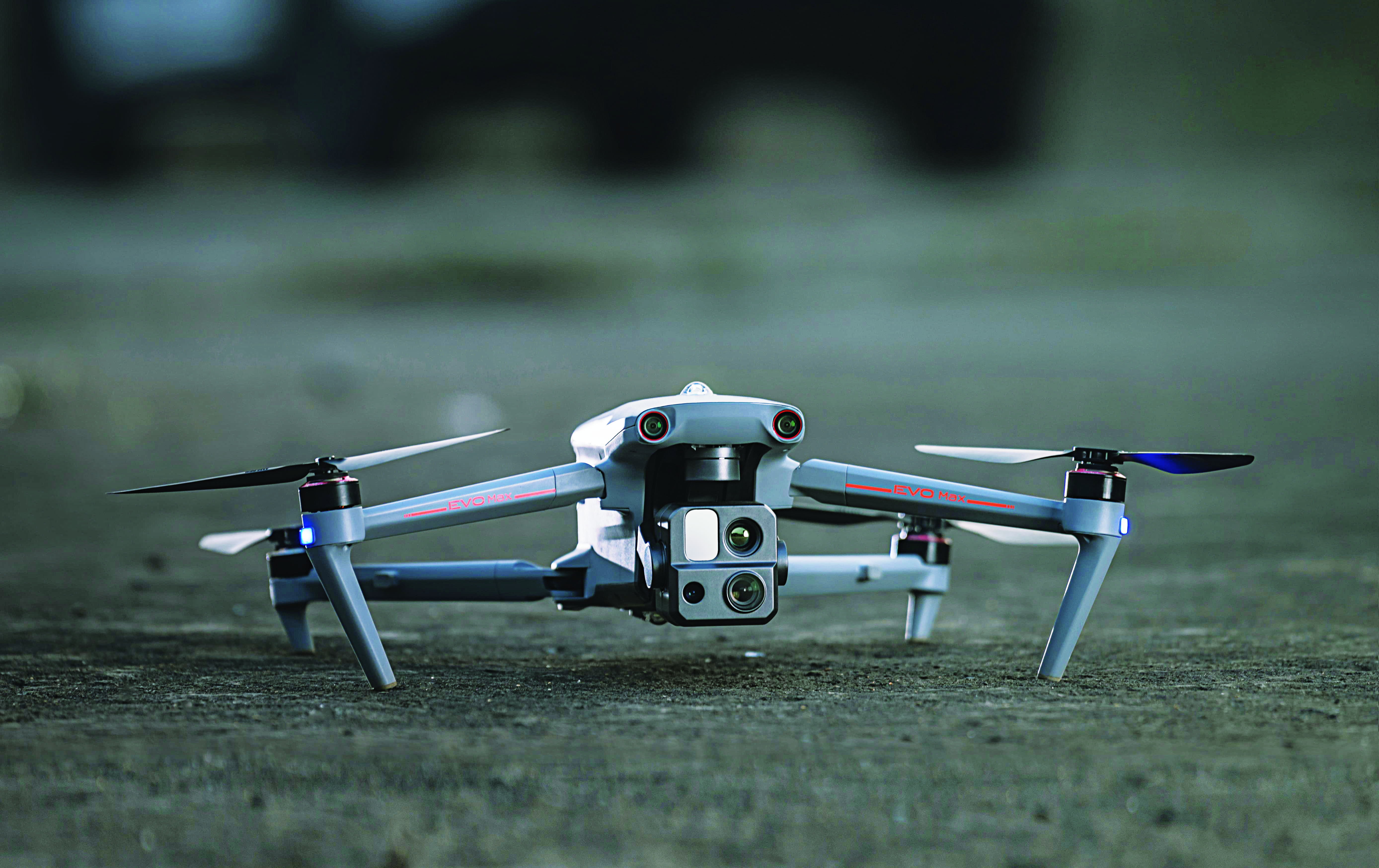
VO Max 4T (Image: Autel Robotics)
Flight Platform
For enterprise and professional applications
The EVO Max 4T autonomous flight platform provides omnidirectional obstacle avoidance and tri-anti-interference capability to ensure flight safety and stability in high-interference environments. It is equipped with three high-quality cameras including a 48 MP telephoto camera, a 50 MP wide-angle camera and an infrared camera. The platform has a range of navigation and data-acquisition functions, including 3D flight routes, PinPoint Mode, Team Work, Polygon Mission, Waypoint Mission and Oblique Photography. EVO NEST is a base for automatic take-off, landing, charging and mission planning for EVO series UAVs. It is designed for all-weather operation and can be easily transported. Autel Robotics, autelrobotics.com
Abstracts for the ION GNSS+ 2023 show, “GNSS + Other Sensors in Today’s Marketplace,” are due March 3.
ION GNSS+ will take place Sept. 11-15 at the Hyatt Regency Denver at Colorado Convention Center in Denver.
ION GNSS+ 2023 is the world’s largest international technical meeting and showcase of GNSS technology, products and services. The show aims to bring together leaders in GNSS and related positioning, navigation and timing to present advances, introduce new technologies, update current policy, demonstrate products and exchange ideas.
The two tracks covered during the show will be commercial and policy tracks and research tracks.
The commercial and policy tracks will include navigation for mass market, autonomous and safety critical applications and future trends in navigation. The research track will cover multisensor and autonomous navigation, algorithms and methods and advanced GNSS technologies.
Interested parties may submit their abstracts on the ION GNSS+ 2023 website.