JAVAD GNSS, a global provider of high-precision GNSS solutions, and Inertial Labs, a VIAVI Solutions Company, have entered a strategic partnership to integrate Inertial Labs’ IMU-P modules with JAVAD’s advanced OEM GNSS receivers. This collaboration introduces a new GNSS+INS platform designed to deliver accuracy, stability and resilience, even in environments where GNSS signals are weak or unavailable.
Central to this advancement is the JAVAD TR-3Si receiver, engineered for compatibility with professional IMU modules. Combined with the advanced IMU-P units, the system is positioned to offer high levels of precision and reliability, supporting mission-critical requirements in aerospace, defense, autonomous vehicles, UAVs, robotics, precision agriculture and other demanding sectors.
Inertial Labs’ IMU-P modules can perform in dynamic settings, providing continuous orientation and acceleration data for sensor fusion. The integration of this inertial technology with JAVAD’s established GNSS systems enhances navigation accuracy and efficiency in both GNSS-accessible and GNSS-denied environments.
JAVAD GNSS is expanding its support for IMU modules and is expected to release further updates on this initiative.
Septentrio is collaborating with Gateworks Corporation, a US-based manufacturer of high-quality single board computers. Gateworks is now bringing its first Septentrio-based product to market, a new M.2 card called GW16160, which provides reliable high-accuracy positioning powered by the mosaic-X5 GNSS module.
The mosaic-X5 module is a multi-frequency, multi-constellation receiver renowned for its high level of resilience to GNSS jamming and spoofing, thanks to the built-in AIM+ (Advanced Interference Mitigation) technology. It also features a suite of GNSS+ algorithms that ensure robust positioning of rugged systems operating in challenging industrial environments.
The GW16160 card with mosaic-X5 is a high-quality positioning solution for autonomous robots, UAVs and industrial mission-critical applications.
Designed and manufactured in the USA, the GW16160 allows engineers to integrate high-accuracy GNSS into edge systems without bulky external receivers or complex RF design. This ultra-low power card features an M.2 A/E-Key interface with USB 2.0 connectivity for plug-and-play integration.
Exail has signed a contract to supply 100 Phins compact inertial navigation systems (INS) to a U.S.-based global defense company for use in unmanned underwater vehicles (UUVs). The Phins Compact INS is designed to provide precise navigation capabilities in challenging environments, remaining functional even when external signals are disrupted. The system’s compact design enables rapid integration into UUVs, allowing for flexible and efficient mission operations in dynamic maritime settings.
According to the company, this contract strengthens Exail’s global leadership in subsea navigation, with its INS technology trusted by more than 50 navies and widely deployed on a broad range of subsea autonomous vehicles worldwide. It also represents a key milestone in the company’s expanding presence in the United States, supporting defense programs with proven, high-performance solutions.
Swift Navigation has completed another funding round to fuel its centimeter-level precision service. The Skylark Precise Positioning Service is a cloud-based service that corrects errors in GNSS signals, improving accuracy to centimeter level and enabling mass-market adoption of applications in autonomous driving, robotics, precision logistics, and V2X communication.
Skylark is a real-time, cloud-based service that meets ISO 26262:2018 functional safety standards for road vehicles. Unlike ASIL-certified positioning solutions that rely on costly physical data centers, Skylark operates entirely in the cloud.
Skylark powers more than 10 million ADAS-enabled and autonomous vehicles worldwide and supports global programs for 20+ automotive OEMs and Tier 1 suppliers, top robotics companies, and a large commercial fleet operator.
This latest financing reflects strong market demand for Swift’s approach to precise positioning. Unlike traditional precise positioning technologies, Skylark leverages advanced atmospheric modeling, cloud-based architecture and carrier-grade networks to deliver unmatched reliability, safety and cost efficiency at scale.
The $50 million Series E financing round was led by Crosslink Capital. The round saw strong participation from existing investors New Enterprise Associates (NEA), Eclipse Ventures, EPIQ Capital Group, First Round Capital, TELUS Global Ventures, and Potentum Partners alongside new investors Niterra Ventures, AlTi Tiedemann Global, GRIDS Capital, Essentia Ventures, Shea Ventures, and EnerTech Capital. This funding brings Swift Navigation’s total capital raised to over $250 million.
Q-CTRL has completed a major field trial with Australian Defence on board the Royal Australian Navy’s Multi-role Aviation Training Vessel (MATV), the MV Sycamore. The results of the trial demonstrated advancements in software-ruggedized quantum sensing for navigation.
In the trials, Q-CTRL field deployed a quantum dual gravimeter, which measures tiny variations in Earth’s gravity as part of a next-generation quantum-assured positioning, navigation, and timing (PNT) system operable when GPS is unavailable or untrusted.
This first trial saw over 144 hours of continuous operation and successful data collection with no human intervention during real maritime operations.
“Quantum sensors provide a near-term opportunity to achieve transformational defense capabilities, but previous deployments in the field have struggled to deliver defense-relevant performance,” said Q-CTRL CEO and founder Michael J. Biercuk. “Operating on a real moving vehicle is just not the same as conducting a science experiment; at Q-CTRL, we’ve taken a different approach to getting quantum sensors out of the lab, focusing on software as the critical enabler of performance in the real world.”
Earlier this year, Q-CTRL announced successful airborne field trials of a new generation of quantum-magnetic navigation solutions, Ironstone Opal, validated for the first time to outperform comparable conventional alternatives in challenging real-world settings by 50 times.
Developed and fielded in 14 months, the dual gravimeter was installed in a “strapdown” configuration (bolted to the floor) in the space of a single server rack in a communications room onboard MV Sycamore. The sensor consumed only 180W of power – about 10 times less than a household toaster.(Photo: Q-CTRL)
The newly announced trials of Q-CTRL’s gravimetric navigation technology open opportunities to bring quantum-assured navigation to maritime vessels where magnetic navigation can be less effective.
GPS denial has become one of the most pressing strategic challenges in both defense and commercial settings, risking major disruptions to civilian and military operations. Quantum navigation promises a robust and reliable GPS backup that cannot be jammed or spoofed.
Q-CTRL’s navigation capability is urgently needed in contested maritime environments, as instances of spoofed signals caused significant disruptions to ships in the Middle East waterways as recently as June 23. This causes not only critical logistical issues but disrupts collision avoidance efforts, revealing major safety implications.
In quantum gravimetric navigation, the quantum gravimeter continuously “sees” the otherwise invisible hills and valleys in Earth’s gravity, allowing a navigation computer to compare its observations against known gravity maps. This is similar to orienteering, where one can position oneself on a map by identifying landmarks like valleys, mountains, rivers, or roads. GPS is not needed, making it a robust backup in contested regions.
Q-CTRL’s demonstration with the Royal Australian Navy departs from most previous quantum sensing field trials in that these tests mandated peak performance with full autonomy and without the addition of any special infrastructure. The sensor had to operate as a real navigation system would operate during a defense mission.
The ship’s motion and engine vibrations were sufficient to cause total loss of signal using conventional operating techniques typically employed in research experiments. To address these losses, Q-CTRL’s software-ruggedization strategies recovered operation even while MV Sycamore was underway.
Quantum sensing leverages the physics of light and matter on the smallest scales to enable the detection of tiny signals. Because these devices work based on the fundamental laws of physics and are not affected by drift like other GPS alternatives, their outputs do not change over time, enabling new opportunities where long-term stability is essential. Generally, however, these devices are significantly degraded when taken from a research laboratory into the real world, an issue addressed by Q-CTRL’s software-ruggedization technology.
For more on Q-CTRL’s software-ruggedized quantum sensing technology, read their peer-reviewed technical demonstration published in Nature.
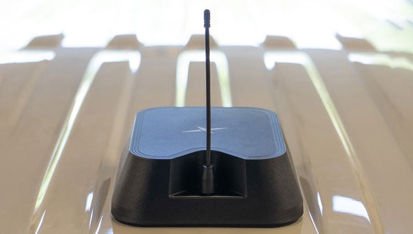
Taoglas has introduced the Patriot series, a compact, multi-function combination roof mount antenna designed for connected vehicle fleets in emergency services, utilities and commercial sectors. The Patriot integrates up to 18 antenna elements within a single low-profile enclosure, aiming to provide robust multi-network connectivity while reducing vehicle roof clutter and simplifying installation processes
The antenna was originally developed for the Ford Interceptor, allowing for a direct replacement of the vehicle’s OEM antenna. This approach maintains the original antenna’s functionality and adds multi-radio connectivity, eliminating the need for additional holes to be drilled in the vehicle roof. The design is intended to streamline and reduce installation time and costs for upfitters, offering public departments potential savings on antenna-related expenses and removing the requirement to fill in roof holes when vehicles are resold.
The Patriot supports 5G and 4G cellular networks across the 600–6000 MHz range, dual-band GNSS (L1 and L1/L5) with a secondary GNSS (L1), Wi-Fi at 2.4 GHz, 5.8 GHz and 7.1 GHz, SDARS at 2.3 GHz, and LMR/TETRA at 380 MHz to 400 MHz and 700 MHz to 900 MHz. This enables the antenna to deliver concurrent broadband, navigation, telemetry and voice services. A dedicated whip element with full P25 VHF/UHF/700-900 MHz support is available in multiple lengths to meet various frequency requirements.
The platform is flexible and scalable, with the patent-pending design allowing for customization to specific application needs. Full 17- and 18-in-1 configurations are currently available, and additional variants with up to 18 integrated elements are planned based on customer requirements. This modular approach enables organizations to match antenna performance and connectivity with operational needs while maintaining a consistent mechanical design.
The Patriot’s housing is rated IK08 and IP69K for impact and water resistance, measuring 205 mm in length by 180 mm in width, with a variable whip height between 60 mm and 164 mm. The enclosure is designed to fit between vehicle roof ribs and uses the existing OEM mounting hole. A custom-engineered foam gasket ensures a secure and interference-free installation on curved vehicle roofs. The aerodynamic design is intended to enhance vehicle aesthetics and reduce wind resistance, and the antenna is available in black, white and other colors to match vehicle exteriors.
Signal performance is engineered for optimal gain, isolation and efficiency across all supported frequency bands. Cable types, lengths and connector options are customizable to suit specific installation requirements.
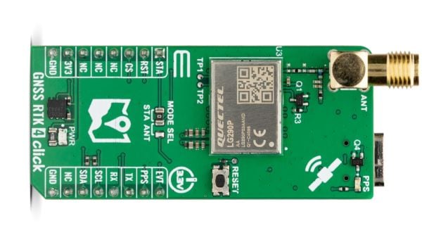
GNSS RTK 4 Click is a compact add-on board from Mikroe that provides high-precision GNSS positioning with real-time kinematics (RTK). The board features the LG290P a quad-band GNSS module from Quectel capable of receiving signals from GPS, GLONASS, Galileo, BDS, QZSS and NavIC while using SBAS for enhanced accuracy.
“This new Click board allows designers to simply and quickly develop systems with sub-metre positioning accuracy,” comments Nebojsa Matic, CEO of MIKROE. “Autonomous navigation, UAVs, intelligent robotics, surveying, and precision agriculture are just some of the applications that will benefit.”
GNSS RTK 4 Click supports multi-mode RTK algorithms with fast convergence times and high accuracy, interference detection, and integrity monitoring, ensuring sub-meter positioning in demanding environments. It features UART and L2C interfaces, a USB Type-C port for standalone configuration, and a backup battery option for continuous operation.
GNSS RTK 4 Click also features the ClickID function which enables automatic identification by the host system, simplifying use. It is fully compatible with the mikroBUS socket and can be used on any host system supporting the mikroBUS standard. It comes with the mikroSDK open-source libraries, offering excellent flexibility for evaluation and customization.
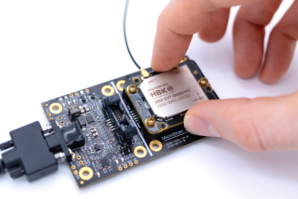
MicroStrain by HBK has launched the 3DM-CV7-GNSS/INS, an ultra-compact, tactical-grade inertial navigation system (INS) designed for seamless integration into space-constrained platforms.
Combining advanced inertial technology with tightly coupled, onboard dual-frequency GNSS receivers, the 3DM-CV7-GNSS/INS delivers the precision and reliability needed for navigation and localization in dynamic environments, particularly those where GNSS signals may be weak, intermittent, or denied altogether.
From autonomous robotics to drones and unmanned ground vehicles, this new solution helps engineers overcome one of the toughest challenges in modern navigation: achieving consistent, high-quality data in challenging conditions.
Weighing 15.6 grams and measuring 38x30x10mm, the 3DM-CV7-GNSS/INS offers tactical-grade performance without size, weight, or cost trade-offs. Its user-friendly functionality, adaptive extended Kalman Filter, and full industrial temperature calibration deliver robust and reliable data acquisition across a wide range of real-world scenarios.
Engineers benefit from the sensor’s compatibility with open-source platforms such as PX4 and ROS, which enables faster development cycles and easier integration into existing architectures.
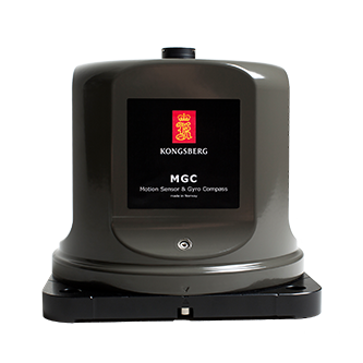
With real-world disruptions increasingly affecting shipping and aviation safety, Kongsberg Discovery’s MGCs (motion gyro compasses) deliver an alternative for reliability, accuracy and resilience in contested environments, according to the company.
Although traditional gyrocompasses are immune to GNSS signal-based attacks by design, many modern navigation systems incorporate GNSS data to enhance positioning accuracy. For maritime operators, having an autonomous and reliable source of heading and positioning data ensures safety and maintains operational continuity in contested or signal-denied environments.
Kongsberg’s MGCs offer resilience, using high-grade strap-down inertial sensors that detect the Earth’s rotation without the need of external input. This allows them to determine true north and maintain precise heading without relying on GNSS. Unlike traditional mechanical gyros, Kongsberg’s MGCs can estimate latitude internally. This ensures consistent accuracy from equatorial regions to the poles.
The system also supports Doppler-based seabed and water-column tracking to determine vessel velocity, eliminating the need for satellite-derived speed data.
MGC Highlights
Kongsberg’s MGCs provide resilient navigation with advanced inertial technology and motion reference capabilities that enable:
Photo: Kongsberg
Continuous latitude estimation from Earth’s rotation measurements
Accurate heading, roll, pitch and heave without GNSS
Versatile support for velocity tracking and input
This robust combination ensures that even when GNSS signals are lost or manipulated by spoofing or jamming, the MGC continues to operate with high precision – offering a resilient navigation backbone when it’s most needed.
Kongsberg’s MGCs are designed to be maintenance-free, eliminating the need for frequent calibration or mechanical upkeep. Other features include:
IMO type-approved: Fully compliant with global navigation standards
Maintenance-free design: No spinning parts and no mechanical drift
Versatile integration: Can be used standalone or seamlessly incorporated into an INS (inertial navigation system)
According to Kongsberg, these attributes make the MGCs suitable for commercial and passenger vessels, offshore platforms and naval ships operating in challenging environments.
High-Q ceramic bandpass filters present a technical opportunity to build jamming-resistant GNSS receivers for mission-critical applications, according to a blog by Knowles Precision Devices.
Bandpass filters play a critical role in mitigating GNSS jamming by isolating legitimate satellite signals from interference. These filters are designed to allow frequencies within the GNSS operational bands (GPS L1/L2, Galileo E1/E5) while attenuating out-of-band noise and intentional jamming signals.
With their low cost and compact form factor, surface acoustic wave (SAW) filters are a natural fit for GNSS receivers, but they struggle in high-interference conditions due to limited out-of-band rejection and broader skirts, Knowles’ Peter Matthews explains. While SAW filters continue to meet performance requirements for consumer devices and systems, high-Q ceramic filters offer a robust upgrade for mission-critical applications needing mechanical and thermal stability, predictable tuning characteristics, and long-term reliability.
Image: Knowles
Q factor is used as shorthand figure of merit (FOM) for RF filters. In short, Q factor is expressed as the ratio of stored versus lost energy per oscillation cycle. It describes specifications like the steepness of skirts (that is, the selectivity) and insertion loss. Overall, losses through a resonator increase as Q factor decrease and will increase more rapidly with frequency for lower values of resonator Q.
Sharp Skirts: Enable precise filtering near the band edges.
High Rejection: Attenuates out-of-band signals and jammers.
Low Insertion Loss: Preserves the integrity of weak GNSS signals.
These attributes are especially important in military and aerospace platforms where GNSS must function reliably in the face of hostile electronic countermeasures. High-Q ceramic filters enable precise frequency discrimination, ensuring that only legitimate GNSS signals reach the receiver.
“Consider a drone conducting reconnaissance in a contested area or an autonomous harvester navigating with sub-inch precision on a farm,” Matthews explained. “Both scenarios require high signal clarity. Knowles’ high-Q ceramic filters, like the GPS L1, are engineered for use in L-band GNSS applications. These filters demonstrate low passband insertion loss (<2.0 dB), high out-of-band rejection (up to 40 dB), and compact dimensions, making them ideal for both portable and embedded systems.
Knowles offers a range of high-Q ceramic filters. See the GPS L1 filter datasheet for detailed specifications.
The European Space Agency (ESA) and Leonardo are embarking on a joint project to explore smart antennas powered by machine learning to block unwanted signals.
Representatives of ESA and Leonardo signed a contract at the Paris Air Show to research and develop machine learning techniques to steer antenna arrays to block out unwanted signals. The project will be developed under the umbrella of ESA’s Navigation Innovation Support Programme (NAVISP).
Smarter antenna designs for resilience
Conventional antennas catch signals from all directions. A controlled reception pattern antenna (CRPA) can focus on signals coming from specific satellites and ignore signals or interference coming from other directions. These types of antennas are used in satellite navigation receivers to block jamming and counterfeit signals. They rely on electronics that control how they adjust their patterns (beamforming).
Under contract with NAVISP, Leonardo — together with ELT Group as subcontractor — will explore the reduction of the distance between the antenna elements to reduce the size and weight of the antenna array, and the use of machine learning to determine the best antenna setup and adjust the settings faster. This approach will lead to smaller, smarter and more effective antennas, especially useful in space-limited environments such as aircraft.
The project covers identification of the smarter algorithm for signal blocking, building and testing a real-time receiver demonstrator based on the selected algorithm, and comparing it to conventional larger antennas. The aim is to reach a Technology Readiness Level (TRL) of 4, delivering a lab-tested technology by the end of the project, in two years.
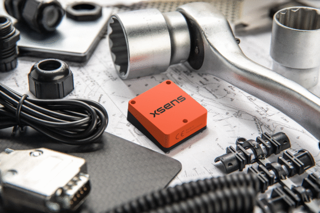
Xsens has launched Xsens Avior, a lightweight, OEM form factor inertial measurement unit (IMU) with a compact 36.8mm x 40mm footprint that offers enhanced performance in a wide variety of industrial and commercial applications.
The Xsens Avior is suitable for products manufactured in high volume thanks to its vertical 10×2-pin socket connector for simple board mounting, and its tolerance of any mounting orientation in all three axes. The product also eases design integration, with UART, CAN, SPI and I2C interfaces on-board and support for RS232 and RS422 via the product’s development kit or an external transceiver.
Xsens has integrated a new generation of sensing components in the Avior, as well as advanced analog filtering for higher stability and noise reduction, resulting in substantially better performance compared to the previous generation product. Heading accuracy is 1° RMS and roll and pitch accuracy is 0.2° RMS. Stability is also enhanced in the Xsens Avior: in-run bias stability in the gyroscope is 8°/hr, and accelerometer in-run bias stability is 15μg.
Weighing 35.2g, the Xsens Avior is enclosed in a robust aluminum housing and has a rating of IP51 and an operating temperature range of –40°C to 85°C. The sensor’s small size, light weight, high performance and robust construction provide value in applications such as drones, 3D mapping, and marine remotely operated vehicles (ROVs).
Flexible product options
The new sensor is available in three versions:
IMU providing calibrated inertial sensor data
Vertical Reference Unit (VRU) providing accurate, calibrated values for roll and pitch, and unreferenced yaw data
Attitude and Heading Reference System (AHRS), providing accurate, calibrated roll and pitch values, and heading data referenced to true North
The Xsens Avior is available in a ready-to-use hardware development kit, and is supplied with free software development kits supporting the C#/C++, Python, ROS 1 and ROS 2 and Matlab environments, as well as full documentation and step-by-step guides to design integration.
Key product specifications:
Typical power consumption: <0.5W
Maximum output data rate: 400Hz
Gyroscope full range: ±300°/s
Accelerometer full range: ±8 g
Magnetometer full range: ±8 G
Fully supported in the MT Software Suite development environment