Hi-Target, a Chinese high-precision positioning enterprise and manufacturer of high-end GNSS equipment, and GMV, a global technology group specializing in advanced navigation solutions, have established a strategic alliance to jointly develop integrated differential service solutions.
Through this partnership, Hi-Target and GMV support a wide range of automation-driven positioning applications — ADAS, robotics, UAVs, precision agriculture, smart infrastructure and intelligent mobility systems.
As industries progressively adopt automated technologies, precise and reliable positioning has become a foundational requirement across application domains. From today’s L2 and L2+ driver assistance systems (ADAS) in vehicles to autonomous UAV operations, robotic platforms, and the emerging needs of Level 3+ mobility solutions, the demand for scalable and high-accuracy positioning continues to grow.
The strategic alliance between the two companies leverages Hi-Target’s strengths in high-precision satellite navigation and user-grade GNSS systems, along with GMV’s extensive global expertise in precise navigation algorithms and satellite-based augmentation services. The result will be a high-availability, low-latency positioning service with global reach.
By combining their complementary technologies, including user-grade GNSS hardware, correction services, and augmentation infrastructure, Hi-Target and GMV will facilitate the adoption of high-precision positioning across various industries and geographic regions.
Their collaboration will support system integrators, OEMs, and solution providers in accelerating the development and deployment of automation in sectors with increasing levels of autonomy.
Advanced Navigation has successfully demonstrated a hybrid solution — AdNav OS Fusion — for long endurance GNSS-denied navigation, a software-fused inertial-centered architecture that can be updated or modified for harsh environments and mission requirements, including on the moon.
This advancement is achieved by integrating a strategic-grade fiber-optic gyroscope (FOG) inertial navigation system (INS) with a new class of navigation aid: a laser velocity sensor (LVS). The result is a fused hybrid architecture that delivers precision and reliability in even the most challenging environments.
Advanced Navigation’s FOG INS, which is sensitive enough to detect the Earth’s rotation, provides that foundation by delivering precise attitude. Complementing this, the company’s LVS uses infrared lasers to measure a vehicle’s ground-relative 3D velocity with exceptional accuracy and long-term stability. Unlike conventional sensors, LVS performs reliably on both ground and airborne platforms, as long as it maintains a clear line of sight to the ground or a stationary surface.
Beyond its role as a velocity aid, LVS also enhances navigation resilience by detecting GNSS spoofing. By comparing its independent velocity measurements against GNSS-derived velocity, LVS adds an extra layer of security to assured positioning, navigation, and timing (APNT) strategies.
AdNav OS Fusion draws on sophisticated algorithms to interpret and filter sensor data. The software is designed to dynamically weigh the input from each sensor, adjusting in real time based on reliability scores, environmental conditions and operational context. This ensures continuous, high-confidence state estimation even when signals are lost, degraded or distorted.
Demonstration with real-world data
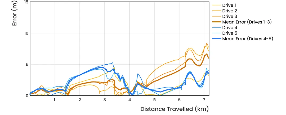
Advanced Navigation conducted a series of rigorous real-world driving tests. Across five trials, the system delivered exceptional performance with an average error per distance traveled of 0.053% compared to a GNSS reference.
At the starting point, GNSS on the INS was disabled in the state estimation process, forcing the system into dead-reckoning mode. RTK GNSS was logged separately as a reference. This approach allows for a direct comparison between the computed dead-reckoning solution and a trusted position reference.
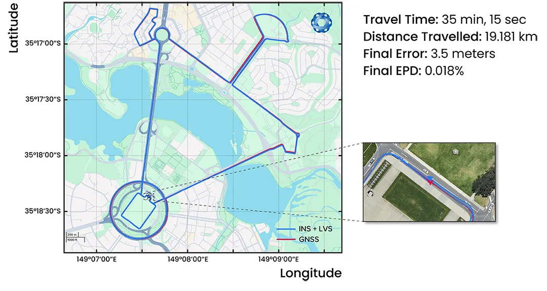
The below data shows dead-reckoning results from a 23 km drive around Canberra, Australia. GNSS was not used at any point in the drive for heading or position. RTK GNSS is shown as the red line, while the hybrid system’s result is shown in blue.
The below results are from a 19.2 km drive around the Parliamentary Triangle in Canberra. GNSS was not used at any point in the drive for heading or position. RTK GNSS is shown as the red line, while the hybrid system’s result is shown in blue.
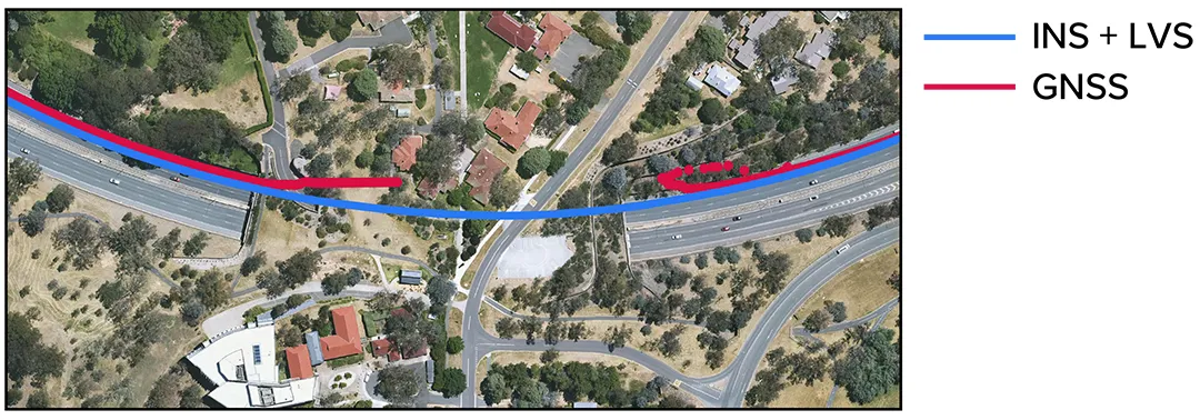
The figure below is a zoomed section from the first test drive, showing GNSS (red) drop out as the test vehicle drove through a tunnel, which completely denied the GNSS reference measurement. The hybrid system’s result can be seen in blue, showing it did not suffer from this error.
These drives were done repeatedly, demonstrating consistent and reliable results each time.
The hybrid system was also tested on a fixed-wing aircraft combined with a tactical-grade INS, demonstrating a final error per distance traveled of 0.045% over the course of a low-altitude flight over 545 km. These results demonstrate the system’s impressive ability to improve navigation performance of the INS in GNSS-denied or contested scenarios. For a more in-depth look into the technology, read the white paper here.
Commercializing space to Earth
LVS is a terrestrial adaptation of LUNA (Laser Unit for Navigation Aid), a space-grade navigation technology developed for autonomous lunar landings. LUNA enables reliable navigation in the harsh environment of space by providing precise three-dimensional velocity and altitude information relative to the Moon’s surface. The result of several years of research and development, LUNA is set to be demonstrated aboard Intuitive Machines’ Nova-C lander as part of NASA’s Commercial Lunar Payload Services (CLPS) program.
By leveraging the engineering insights gained from LUNA, LVS adapts space technology into an Earth-ready solution for terrestrial GNSS-denied navigation.
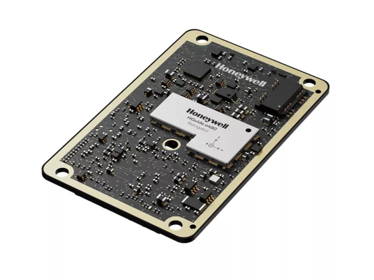
Honeywell has expanded its navigation portfolio with the HGuide o480, a high-performance, single-card inertial navigation system (INS) engineered to deliver precise, resilient localization and attitude data in a low size, weight and power package.
“The HGuide o480 is an engineering marvel and a technological breakthrough,” said Matt Picchetti, vice president, Navigation and Sensors, Honeywell Aerospace Technologies. “For the size, there are no competing products in the industry today that can achieve the same high-performance at the price point, in addition to having the ability to be augmented by the wide array of Honeywell alternative navigation capabilities to form a truly remarkable resilient navigation solution.”
The entire HGuide o480 product line is suitable for a wide range of industries, including the emerging small-factor unmanned aerial vehicles, autonomous ground and underwater vehicles, as well as an extensive range of aerial and terrestrial mapping systems for the geodetics industry.
The HGuide o480 can be integrated directly into the electronics stack of a range of applications requiring precise and robust localization. It can also reduce system size and integration complexity, enabling faster deployment and improved performance for unmanned and autonomous systems across air, land and sea. The system is fully compatible with multiple velocity aiding sensors, including the Honeywell Radar Velocity Sensor, and provides GPS-denied localization performance that is typically unavailable in similar systems.
Additionally, security is built into the fabric of the HGuide o480. Designed to perform in contested and GPS-challenged environments, the system features anti-jamming and anti-spoofing capabilities via Septentrio’s AIM+ technology included with the Mosaic global navigation satellite system (GNSS) receiver. The HGuide o480 is offered with both the triple-frequency Mosaic X5 in a single-antenna configuration and with the dual-frequency, dual-antenna Mosaic H for when GNSS attitude aiding is required. In both cases, the Mosaic delivers best-in-class real-time kinematic (RTK) GNSS performance.
The combination of ST’s Teseo chipsets with FocalPoint’s S-GNSS Auto software delivers enhanced GNSS accuracy in challenging environments
FocalPoint, a UK software company providing next-gen positioning solutions for automotive, wearables and smartphones, has announced a strategic collaboration with STMicroelectronics, a global semiconductor leader serving customers across the spectrum of electronics applications.
The joint offering provides automotive OEMs a combined solution that enhances navigation performance by improving GNSS reliability and accuracy — key to making autonomous vehicles safer.
Within this collaboration, FocalPoint will integrate its S-GNSS Auto software, powered by Supercorrelation technology, onto ST’s Teseo devices, known for their high performance and multi-constellation support. Combined with S-GNSS Auto, they will offer next-level industry-leading reliability and accuracy, surpassing other commercially available options.
GNSS is an important component in advanced driver assistance systems (ADAS), providing absolute location data. However, its accuracy is compromised in urban canyons and forested roads due to signal interference. S-GNSS Auto transforms GNSS into a reliable, high-performance sensor in these challenging scenarios. This allows automakers to harness the full potential of GNSS and confidently extend the operational range of hands-free driving beyond open-sky roads. Delivered as a simple firmware update to the Teseo device, S-GNSS Auto is cost-effective and easy to adopt.
This engagement is a significant milestone in the growth and demand for FocalPoint technology that follows a recent strategic investment from GM Ventures and collaboration with General Motors.
Key findings from the collaboration show that the combined solution of ST’s Teseo devices and FocalPoint’s S-GNSS Auto enhances measurement accuracy by up to four times and position accuracy by up to three times (in challenging multipath environments).
Contact FocalPoint at [email protected] for the full results report.
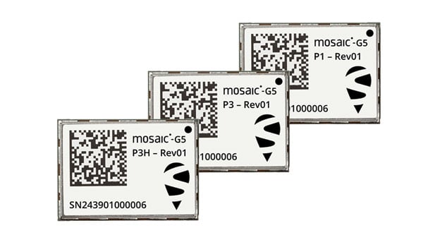
Septentrio, part of Hexagon, has introduced the mosaic-G5 series, expanding its line of compact GNSS receiver modules. The mosaic-G5 modules offer a 60% reduction in size and a 40% decrease in power consumption compared to the earlier mosaic-X5 receiver. The new modules measure 23 mm x 16 mm and weigh as little as 2.2 g, making them suitable for applications where size, weight and power are critical considerations, such as commercial UAVs, robotics and high-volume industrial equipment.
The mosaic-G5 modules offer reliable, high-accuracy positioning even in environments where GNSS signals may be degraded or obstructed. The mosaic-G5 product line includes several variants tailored to different use cases. The triple-band mosaic-G5 P1 is designed for high-volume applications, such as inspection drones and robotic mowers. The quad-band mosaic-G5 P3 and the triple-band heading module mosaic-G5 P3H offer enhanced positioning reliability in challenging conditions and are suited for applications such as delivery UAVs and light show UAVs. The P3H variant can calculate heading with a minimal baseline between two GNSS antennas, enabling accurate navigation for small autonomous device.
The new modules complement the mosaic product line, where the mosaic-X5 receiver remains as the benchmark for world-leading GNSS open signal anti-jamming and anti-spoofing resilience in a small form factor.
The mosaic-G5 modules complement Septentrio’s broader mosaic portfolio, which is recognized for its all-band GNSS technology, accuracy, reliability, and resilience to jamming and spoofing. The established mosaic-X5 receiver remains a benchmark for anti-jamming and anti-spoofing performance in a compact form factor. Like the mosaic-X5, the new modules are compatible with widely used open-source autopilots, such as PX4 and ArduPilot, simplifying integration and reducing development time. An evaluation kit, mosaic-go G5, is available to facilitate testing, and the RxTools user interface is provided for setup and evaluation.
Samples of the new mosaic-G5 P1, mosaic-G5 P3, and mosaic-G5 P3H modules are now available, with volume orders available for delivery later this year.
Read a roundup of recent products in the GNSS and inertial positioning industry from the May 2025 issue of GPS World magazine.
SURVEYING
Integrated Navigation Solution Ideal for inspection and survey applications
Photo: Teledyne
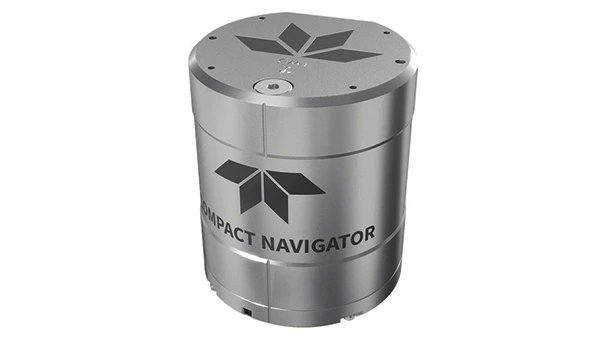
Teledyne Compact Navigator is an ultra-compact autonomous integrated navigation system engineered for subsea and surface vehicles. It is ideal for small vehicles, enabling inspection and survey operations on compact platforms. The system is offered in two depth-rated models, one capable of operating at 4,000 m and another at 300 m. The Compact Navigator consumes less than 7 watts of power, extending mission duration by conserving energy. The system operates fully autonomously, eliminating the need for external aiding or operator intervention. Advanced phased array Doppler Velocity Log technology enhances performance while allowing the device to be mounted on an autonomous underwater vehicle or ship hull.
The Compact Navigator supports a broad range of applications, including autonomus underwater vehicles, shallow water surface navigation, operations in GNSS-denied environments and dynamic positioning for surface vehicles. The system provides true North-seeking gyrocompass-grade performance, and its web-based user interface supports integration, operation and troubleshooting. It is factory-calibrated and offers a battery backup option for reliability in demanding conditions. The system operates independently of satellite signals, making it resistant to jamming or signal loss. This capability is significant for shallow water navigation, where GNSS-based systems may be unreliable.
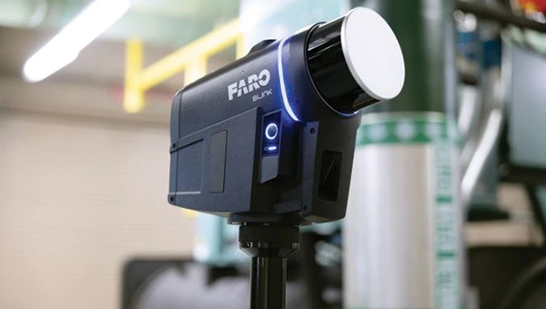
3D Reality Capture Solution Can be used across various industries
Photo: Faro
FARO Blink, a new 3D reality capture solution, is designed to make collecting and utilizing 3D data more accessible and efficient. It centers on software-driven technology integrating advanced visualization and automated workflows through the FARO Sphere XG Digital Reality Platform. This integration aims to simplify operations and deliver faster, more actionable insights for users across various industries.
FARO Blink is tailored for professionals in fields such as surveying and construction. It offers high-quality visualization and can streamline workflows, allowing teams to efficiently capture, view and share 3D data, thereby enhancing project progress and collaboration.
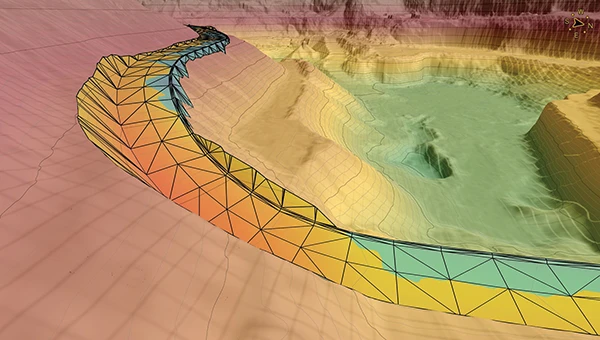
The MS400C is a fully integrated multibeam echosounder designed for uncrewed surface vessels. The new system combines sonar processing, inertial navigation, GNSS positioning and sound velocity sensing into a single unit.
The MS400C seeks to address deployment challenges faced by USV operators during hydrographic surveying. Its compact, lightweight design allows direct mounting on small platforms. Installation involves connecting a few cables to the IPC and power supply and to the primary and secondary GNSS antennas. With preconfigured spatial relationships, operators can deploy and start surveying quickly, reducing configuration errors and ensuring consistent data quality.
Equipped with Auto Survey functionality, the system calibrates parameters based on water conditions, which streamlines pre-survey procedures. Real-time roll compensation and attitude data from the internal measurement unit, combined with sound velocity profiling, ensure high-fidelity depth measurements, even in dynamic conditions. Designed for autonomous and remotely operated survey platforms, the MS400C supports data collection in confined waterways.
The SurveyPod RTK/PPK GNSS system is built for professionals in surveying, agriculture, mining and construction. The system integrates GPS, GLONASS, Galileo and BeiDou signals for improved satellite visibility and accuracy, even in harsh environments.
Powered by a CORS Network, SurveyPod offers real-time, centimeter-level positioning ideal for high-precision applications. The device supports tilt compensation for reliable data collection at angles and boasts up to 16 hours of battery life, making it ideal for extended field operations. With this launch, Nibrus Technologies is expanding its survey equipment portfolio, offering a Made-in-India GNSS solution to the global market.
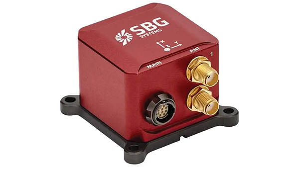
This MEMS-based north-seeking inertial measurement unit (IMU) operates independently of GNSS. It can achieve a heading accuracy greater than 1° secant latitude without GNSS assistance. When integrated with GNSS and SBG Systems’ navigation algorithms, it can achieve INS heading accuracy greater than 0.01°.
Measuring 52 x 52 x 36 mm and weighing less than 150 g, it consumes only 2 watts of power. It offers long-term reliability in demanding conditions, and its ITAR-free status allows unrestricted global deployment. SBG Systems also has developed a new pure north-finding algorithm capable of rapid initialization in both static and dynamic conditions within one minute, as well as an advanced GNSS/INS fusion algorithm that delivers exceptional single-antenna heading accuracy even in low-dynamic environments.
The IMU is particularly suited for subsea applications, including remotely operated vehicles and autonomous underwater vehicles, as well as geospatial and marine surveying tasks requiring precise single antenna heading accuracy.
The first off-the-shelf solutions are expected to be available by early 2026. SBG Systems
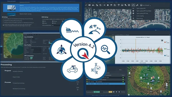
Post-Processing Software With upgraded features
Photo: SBG Systems
Qinertia 4.2 is an updated version of SBG Systems’ post-processing software for GNSS and INS data. One of the notable additions is the beta version of Precise Point Positioning Fixed Ambiguity, which offers centimeter-level accuracy processing without the need for a base station. The update also includes a new RTS smoothing option, the Trajectory Smoother, which enhances INS processing by removing artifacts while maintaining precision. Another feature is the standalone Lever Arm Estimation Tool, now available as a separate application with a simplified interface. The Advanced Virtual Base Station Network Creation has been enhanced with improved base station quality indicators to increase reliability.
It is compatible with the New Ellipse series and supports Teledyne Intrepid INS. The software now offers faster processing speeds, enhanced geodesy functionalities such as base station velocity analysis, and updated tools for assessing processing quality through new status plots. It also supports the latest firmware versions of Ekinox, Apogee, Navsight and Quanta systems. SBG Systems
MACHINE CONTROL
GNSS Receiver and INS System For machine guidance
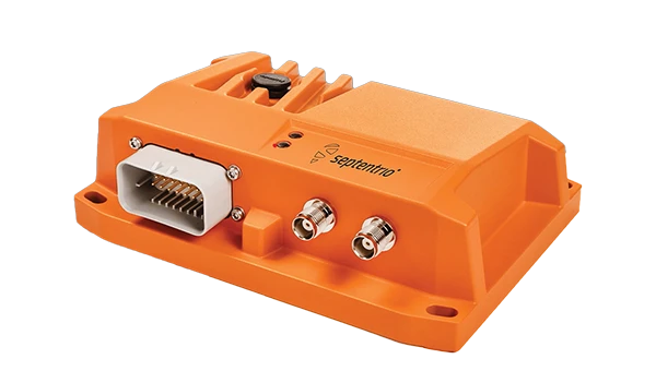
Photo: Septentrio
The AsteRx RB3 GNSS receiver and the AsteRx RBi3 GNSS/INS system are designed to operate in extreme environments. They feature IP69K-rated housings and components that have undergone ISO-standard testing.
The technology offers durability under heavy shocks, vibrations and challenging environmental conditions, making it suitable for demanding applications such as construction, mining and port automation.
The AsteRx RB3 and RBi3 utilize multi-frequency GNSS technology to deliver precise, centimeter-level positioning even in environments where GNSS signals are typically difficult to maintain. The receivers can be mounted externally on heavy machinery or integrated into chassis systems, offering flexibility in placement and simplifying installation.
The AsteRx RBi3 incorporates FUSE+ technology, which combines a high-performance GNSS engine with an industrial-grade inertial sensor. This integration provides accurate orientation data, such as heading, pitch and roll, alongside reliable positioning. In dual-antenna configurations, the receivers deliver sub-degree GNSS heading accuracy immediately upon initialization. The AsteRx RB3 and RBi3 are ideal for machine guidance in industries requiring rugged equipment to maintain precision under extreme conditions.
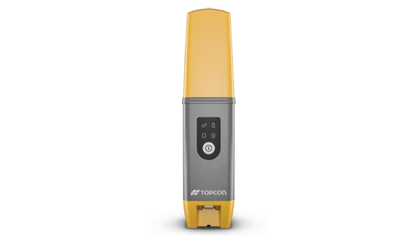
Handheld Reality Capture Solution For maximum mobility
Photo: Topcon Positioning
Designed for mass data solutions, the CR-H1 utilizes PIX4Dcatch, a specialized application with integrated lidar that runs on iPhone devices. It collects images and employs photogrammetry to create detailed, full-color 3D point clouds. The iPhone connects to Topcon’s HiPer CR receiver, enabling the application to collect georeferenced images. The receiver and iPhone are mounted on a specialized handle designed and manufactured by Topcon so that users can capture point clouds without a tripod.
The CR-H1 can be used for utilities and subsurface mapping, construction verification and earthworks, civil engineering and site verification, land surveying and forensics and 3D data capture. Topnet Live subscriptions are available for the CR-H1, providing real-time GNSS corrections that deliver higher-quality point clouds.
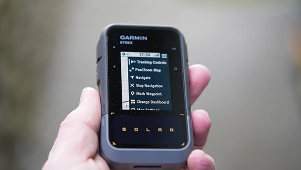
Handheld GPS Device Can provide up to 200 hours of GPS navigation on a single charge
Photo: Garmin
The Garmin eTrex Solar is a handheld GPS device with a built-in solar charging feature. This feature allows for potentially unlimited battery life in optimal sunlight conditions. Even without direct solar input, the device can provide up to 200 hours of GPS navigation on a single charge, making it suitable for extended trips with limited access to power.
The device supports GPS, GLONASS, Galileo, QZSS, IRNSS and Beidou. It features a rugged design, an IPX7 water resistance rating, and a compact, lightweight body that can be attached to a backpack or worn around the neck. Users can import GPX files and navigate to waypoints, courses and geocaches. It also includes a three-axis compass and can store up to a thousand waypoints, 50 courses and 200 activities.
Users can connect the eTrex Solar to their smartphones through the Garmin Explore app, which enables additional features such as geocaching details, weather updates, software updates, trip planning, and cloud storage syncing.
New Product Offerings Now featuring marine GNSS antennas
Photo: Geo-matching
Geo-matching has expanded its product database to include GNSS antennas. The initial marine GNSS antennas featured in this new category are the VP6300 from Calian GNSS, formerly Tallysman, and the AV34 from Trimble.
Geo-matching features detailed information on more than 1,300 products across 63 categories for surveying, navigation and machine guidance. The website is designed to guide users through complex product specifications, offering access to brochures, case studies, product videos and professional reviews. Among the many categories available on Geo-matching.com are hydrographic processing software, GNSS receivers, GIS software, inertial navigation systems, total stations, UAVs, sidescan sonars, imaging sonar and more. The platform encourages users to browse its extensive catalog, upload new products, leave reviews and register their companies to add products to the database.
Mapping UAV With a new “Smart Return-to-Home” feature
Photo: Flyability
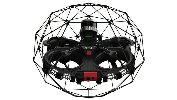
Flyability has introduced a “Smart Return-to-Home” (RTH) feature for its Elios 3 UAV, designed to enhance its autonomous capabilities. This feature allows the UAV to return to its take-off point using the shortest available path while avoiding obstacles in real time.
During flight, Smart RTH monitors battery levels through a new flight management gauge, notifying the pilot when it is time to return. The feature is activated via Flyability’s Cockpit flight app, and pilots can take manual control at any point. By automating the return process, the system helps pilots focus on inspections without concerns about battery management or navigation in complex environments. Smart RTH uses lidar scans to generate a flight plan that the UAV executes independently.
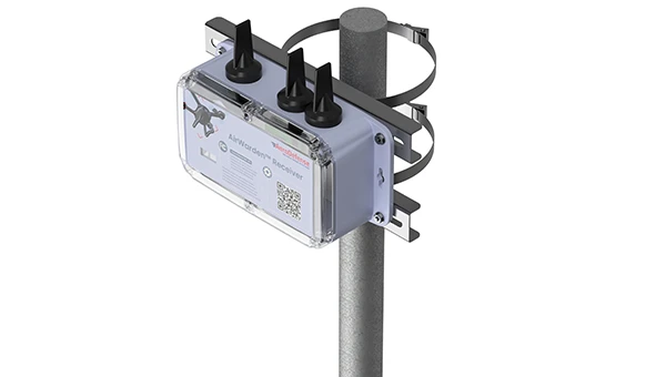
The AirWarden Remote ID Receiver detects and decodes Remote ID signals broadcast by UAVs. It is designed for organizations and authorities that need to monitor UAV activity for safety, security and compliance with regulations.
It decodes the information transmitted by UAVs in accordance with FAA and other regulatory standards. The data it captures includes the UAV’s identification number, its precise location (latitude, longitude and altitude), the takeoff location, operator location if available, timestamps, and other relevant metadata.
The AirWarden can be deployed as a standalone unit or integrated into larger security and monitoring systems. Users interact with the system through a web-based or software interface that facilitates live monitoring, alert management, and data analysis.
Additionally, the AirWarden can integrate seamlessly with other security infrastructure, such as video surveillance and access control systems. This integration seeks to improve how security teams automate responses and coordinate actions when unauthorized or suspicious drone operations are identified.
SiTime Corporation has introduced Symphonic, its first mobile clock generator featuring its integrated MEMS resonator, the SiT30100. The device is designed to deliver precise and resilient clock signals for 5G and GNSS chipsets, supporting efficient power consumption in mobile and IoT devices, including smartphones, tablets, laptops and asset trackers. According to SiTime, the Symphonic clock generator combines the functions of up to four separate timing devices, which helps simplify system design and reduces circuit board space requirements.
The integrated temperature sensor in the SiT30100 provides accurate data to compensation algorithms, enabling improved frequency stability. This results in improved GPS accuracy and faster lock times, which are critical for maintaining stable performance in challenging environmental conditions. The device operates within a temperature range of -30°C to 90°C and is engineered for dynamic stability and power optimization, helping to mitigate electromagnetic interference.
Symphonic offers four clock outputs, each capable of delivering 76.8 MHz, 38.4 MHz or 19.2 MHz, suitable for baseband, radio frequency and GNSS applications. The integrated MEMS resonator eliminates the need for an external resonator, resulting in a compact, single-chip solution with an area of 2.22 mm². The device also features a high-precision temperature-to-digital converter with a single-wire UART interface, supporting frequency stability as low as plus or minus 0.5 parts per million.
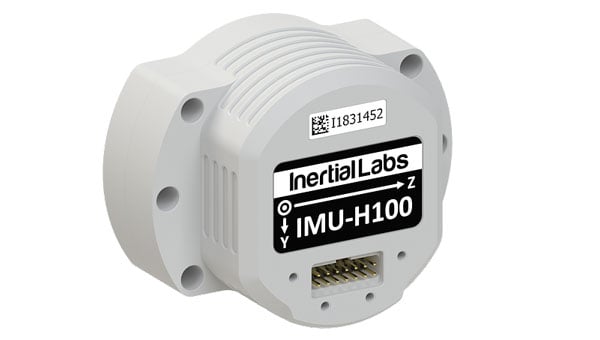
Inertial Labs, a VIAVI Solutions company, has released the IMU-H100, a micro-electromechanical systems inertial measurement unit (IMU) designed to improve tactical guidance and navigation for UAVs, short-range missiles, precision-guided munitions and a range of commercial applications.
As technology for unmanned vehicles advances and safety considerations take precedence, both military and commercial sectors are increasing their adoption of IMUs, which are critical for navigation and control systems. An IMU can track angular velocity and linear acceleration using MEMS gyroscopes and accelerometers. These devices are now considered essential for guidance, navigation, orientation and stabilization, especially in short- and medium-range flight control systems. Their applications extend to autonomous vehicles operating on land, at sea and in aerospace and defense sectors.
The IMU-H100 is a tactical-grade unit that features accelerometers and gyroscopes on all three axes. It offers a gyro bias of 1° per hour and an accelerometer bias of 1 mg. The unit measures 5 cubic inches and weighs 160 g. According to the company, the IMU-H100 surpasses comparable products in data rate, measurement range, stability and repeatability, even under challenging conditions such as vibration, shock, high acceleration, spinning, temperature changes and acoustic noise.
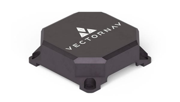
NAL Research and VectorNav Technologies — two U.S.-based leaders in assured position, navigation, and timing (APNT) solutions — are joining forces to develop and produce Iridium STL (satellite time and location)-aided inertial navigation systems (INS) designed to meet the increasing demand for resilient PNT in GNSS-denied environments.
Both companies will be exhibiting and discussing the collaboration during the SOF Week Exposition in Tampa, Florida, May 5–8, NAL Research (#3005) and VectorNav (#1941).
Operators of uncrewed systems, in particular, can benefit from implementing an INS solution that leverages NAL’s Iridium STL-enabled APNT receivers to maintain critical operations in areas where GPS/GNSS signals are denied or degraded.
For such applications, VectorNav is leveraging its VN-210E GNSS-aided INS, which combines a tactical-grade IMU with an L1/L2 GNSS receiver in a miniature, board-mount package. Designed for maximum modularity, the VN-210E hosts VectorNav’s tightly coupled INS and includes four serial ports that enable simultaneous integration with multiple external PNT-aiding sources, such as NAL Research’s ALTM Gen2 Mini Iridium STL receiver. When paired, the system provides a high-rate and continuous position, velocity and attitude solution — even in dynamic applications and in GNSS-denied environments.
“This complete offering delivered through our high velocity collaboration with VectorNav will deliver dynamic innovation to the emerging APNT market,” said NAL Research President Robert Bills. “Our partnership streamlines our customers’ implementation of alternative APNT sources. We look forward to helping government and enterprise users achieve operational success by enabling the ability to rapidly implement highly accurate and reliable navigation solutions.”
NAL Research and VectorNav will continue to focus on co-developing product solutions that combine VectorNav’s industrial and tactical-grade INS with NAL Research’s Iridium STL receivers. Future offerings will focus on reducing SWaP-C (size, weight, power and cost), increasing environmental resilience, and supporting MIL-STD compliance for defense and aerospace applications.
“The demand for robust APNT solutions, manufactured at scale and capable of supporting dynamic autonomous systems, is growing rapidly — particularly in the critical maritime domain,” said Jakub Maslikowski, VP of business development for VectorNav. “This collaboration with NAL Research will help to realize the emerging LEO satellite PNT capability and strengthen the U.S. and allied nations’ resilience when operating in contested environments.”
Teledyne Marine has launched the Teledyne Compact Navigator, an ultra-compact autonomous integrated navigation system engineered for subsea and surface vehicles. It is ideal for small vehicles, enabling inspection and survey operations on compact platforms. The system is offered in two depth-rated models, one capable of operating at 4,000 m and another at 300 m. The Compact Navigator consumes less than seven watts of power, extending mission duration by conserving energy. The system operates fully autonomously, eliminating the need for external aiding or operator intervention. Advanced phased array Doppler Velocity Log (DVL) technology enhances performance while allowing the device to be mounted on an autonomous underwater vehicle or ship hull.
Compact Navigator supports a broad range of applications, including ROVs, AUVs, shallow water surface navigation, operations in GNSS-denied environments and dynamic positioning for surface vehicles. The system provides true North-seeking gyrocompass-grade performance, and its web-based user interface supports integration, operation, and troubleshooting. It is factory-calibrated and offers a battery backup option for reliability in demanding conditions. The system operates independently of satellite signals, making it resistant to jamming or signal loss. This capability is significant for shallow water navigation, where GNSS-based systems may be unreliable.
Read a roundup of recent products in the GNSS and inertial positioning industry from the April 2025 issue of GPS World magazine.
OEM
INS With three additional GNSS receiver variants
Photo: Topcon
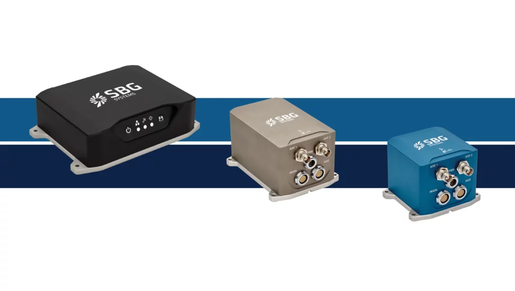
SBG Systems has upgraded its inertial navigation systems — Ekinox, Apogee and Navsight — with new GNSS receiver options. The latest update introduces three additional GNSS receiver variants.
These include:
Marinestar, which supports Fugro Marinestar, delivering precise point positioning (PPP) with centimeter-level accuracy via L-band corrections without requiring a base station. It is optimized for marine applications.
HAS Ready / NavIC, which includes Galileo E6 support for the upcoming Galileo High Accuracy Service (HAS), offering free decimeter-level PPP corrections globally. Additionally, it supports the Indian NavIC system.
Centimeter-Level Augmentation Service, which is tailored for users in Japan; this variant utilizes QZSS L6 signals to provide free PPP corrections without external services.
All GNSS variants integrate seamlessly with SBG Systems’ antenna portfolio and Qinertia post-processing software. Users select the appropriate GNSS variant at purchase to match their operational requirements. These enhancements aim to provide versatile solutions across diverse industries while ensuring reliable performance.
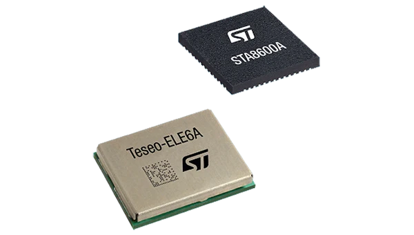
The GNSS receivers in the Teseo VI family use multi-constellation and quad-band signal processing on a single chip, achieving centimeter-level accuracy for various applications. The Teseo VI family includes the STA8600A and STA8610A models. These receivers are designed for automotive applications such as advanced driver assistance systems and autonomous driving, as well as industrial uses, including asset tracking, mobile robots and precision agriculture.
The Teseo VI+ variant can host enhanced positioning engines developed by third-party companies, providing real-time kinematics for centimeter position accuracy.
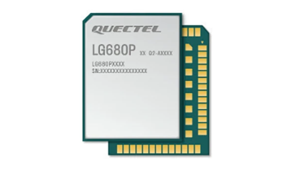
The LG680P is a multi-constellation, quad-band GNSS module designed for high-precision positioning and to enhance signal quality and precision through concurrent reception of L1, L2 and L5 frequency bands. It supports Galileo E6, QZSS L6 and BDS B2b signals for precise point positioning, ensuring horizontal accuracy of up to 0.8 cm + 1 ppm without requiring local or broadband connectivity.
To ensure signal integrity in environments with electromagnetic interference, the module features professional-grade anti-jamming technology, including built-in NIC algorithms that suppress narrow-band interference. It supports external active antennas for enhanced signal reception and positioning accuracy. It is ideal for applications such as autonomous lawnmowers, delivery robots, surveying equipment and precision agriculture. Quectel complements it with two external GNSS antennas: the YEGR001W8AH geodetic antenna and the YEGD006U1A compact patch antenna.
The New Ellipse firmware upgrade for the Ellipse product line allows the system to now be used as an attitude and heading reference system or inertial navigation system. It is designed to enhance navigation, attitude and heave performance for stable and accurate positioning, even in challenging conditions.
It introduces advanced GNSS-denied capabilities, featuring newly integrated flags that trigger when GNSS jamming or spoofing threats are detected. This allows users to reject or re-enable external sensors — such as GNSS — without resetting the filter. The user-friendly interface allows for fast and flexible configuration using simple command lines, enabling users to tailor the Ellipse to their specific needs and applications.
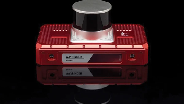
Localization Solution Operates in GNSS-denied environments
Photo: OxTS
WayFinder is a localization solution designed for GNSS-denied environments. It integrates a GNSS/INS system, onboard processor, lidar scanner and two cameras, enabling precise navigation in areas with limited satellite coverage. The system features Lidar Boost, a software technology that enhances GNSS/INS performance by processing lidar data to compensate for missing or inaccurate GNSS updates in real time. This ensures high-accuracy localization and seamless transitions between GNSS-supported and GNSS-denied environments.
WayFinder enables precise navigation for autonomous vehicles in ports, mining and indoor automotive testing without fixed infrastructure. It also provides reliable positioning for surveyors in areas with limited GNSS coverage.
Virtual Surveyor Version 10 introduces Basic Topographic Design tools, allowing users to document terrain changes such as graded roads, water ponds and building surfaces. The software now features four subscription plans — Valley, Ridge, Mountain and Peak.
Ridge plan: Focuses on surveying a single moment in time using one drone data set.
Mountain plan: Adds Timelines to compare surveys across different times, visualizing changes through Time Steps.
Peak plan: Includes advanced Topographic Design tools for planning future structures by creating new Time Steps. These tools allow users to design features such as roads or ponds directly on UAV-derived models, with automated alignment and volume calculations for cut-and-fill operations.
Version 10 introduces drawing guides, available in the Ridge plan and above, enabling precise drawing of points at specific intervals or angles. Walk Mode, included in all plans, allows users to explore 3D terrain at ground level for better visualization. Timelines, featured in the Mountain and Peak plans, facilitate the comparison of multiple surveys conducted at different times and the integration of future designs. These improvements seek to streamline processes for engineering surveyors, supporting applications in construction, mining and water management.
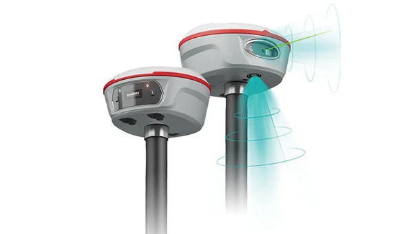
The Jupiter Laser RTK integrates GNSS, auto-IMU, laser and dual camera systems into a single unit. It incorporates a precise green laser that remains visible even in bright daylight. This feature allows for precise measurements of points in hard-to-reach, signal-blocked or potentially hazardous locations. It also features a night vision camera, allowing users to see feature points even in low-light conditions. The RTK system’s laser range is up to 50 m, making it suitable for challenging surveying environments. It incorporates visual technology to offer surveyors an immersive experience during surveying and stakeout operations, improving working efficiency and productivity.
Version 2.1.0 of AgEagle Aerial Systems’ eBee VISION application software introduces circular and grid mapping features, allowing users to generate 2D or 3D maps using external post-processing software for more comprehensive geospatial data.
The eBee VISION 2.1.0 can continue missions in GNSS-denied environments and allows manual deactivation of GNSS to prevent jamming or spoofing. It implements the STANAG 4609 standard, the official format for motion imagery exchange within the NATO nations. This involves embedding UAV position and camera information into the videos recorded by the UAV and those broadcasted by the Ground Control Station. Its inclusion in the system seeks to enhance interoperability with third-party applications, which is key for military-grade UAVs.
It offers enhanced control over the Silent Tactical Landing feature. Users can now manually adjust the landing position on the map, with the system providing range estimates to inform operators of the UAV’s reach. This functionality offers greater flexibility in mission planning and execution, particularly in tactical scenarios requiring precise landing control. The system is ideal for defense, public safety and utilities applications.
‘Drone-in-a-Box’ Solution Designed for vehicle-mounted deployments
Photo: DJI
The DJI Dock 3 “drone-in-a-box” solution is designed for vehicle-mounted deployments and 24/7 remote operations in various environments. This system is compatible with the Matrice 4D and Matrice 4TD UAVs, which feature advanced cameras and IP-rated protection for challenging conditions. The UAVs are ideal for public safety, emergency response and infrastructure inspection.
This system supports flexible deployment options, including vehicle-mounted setups optimized for emergency operations and long-distance inspections. It enables horizontal calibration and cloud-based dock location adjustments. Two docks can be mounted on a single vehicle to facilitate dual-UAV rotations for enhanced efficiency. In fixed deployments, the D-RTK 3 Relay Fixed Deployment Version can be added to improve video transmission and satellite connectivity.
The Matrice 4D and 4TD UAVs have a wide-angle camera, medium tele camera, tele camera and laser range finder. The Matrice 4D features an advanced camera suite designed for high-precision mapping. The Matrice 4TD includes an infrared thermal camera for public safety and emergency response applications. The system includes a Flight Termination System to support regulatory compliance in strictly controlled airspace. This system can manually or automatically stop drone operations if necessary.
Casia G Release 4.0 is a software update that enables nighttime detection of aircraft, allowing 24/7 beyond visual line of sight (BVLOS) UAS operations. The update supports BVLOS flights up to 400 ft at night without requiring hardware modifications, offering detection of both cooperative and non-cooperative aircraft. The system detects aircraft at distances of up to 16.7 km with 360° coverage, ensuring safe nighttime operations. When multiple units are used, triangulation technology provides accurate range, altitude and satellite data for intruding aircraft. The update leverages existing hardware to detect navigation and anti-collision lights at night.
The MAS10 is a 77 GHz FMCW marine radar system designed to enhance navigation safety in congested environments under all weather conditions. The ultra-high-definition W-band radar provides centimeter-level resolution, enabling vessels to detect and identify small hazards in heavily trafficked waterways.
Unlike optical and infrared sensors, W-band radar technology penetrates fog, heavy rain and snow, ensuring reliable detection. It operates effectively in low-visibility scenarios, including complete darkness, intense sunlight and shadowed areas where cameras and lidar may struggle.
The Eagle Series line of spatial 3D scanners feature lidar and imaging sensors and are designed for various applications, including reverse engineering, digital twinning, asset management, extended reality, precision mapping and 3D printing.
The series offers scanning capabilities with a range of up to 140 m and precision within 2 cm at 10 m. The lightweight scanner is designed for portability, with a built-in battery providing up to one hour of continuous use.
The scanners are available in Standard and Max versions. The Max model features four 48 MP cameras, enhancing scanning efficiency and producing vivid 8 K panoramic photos. With a point cloud frequency of 200,000 points per second, the Eagle Series is designed for applications requiring highly detailed spatial data.
Upgraded Mapping Package With Google Maps downloads
Photo: Golden Software
Golden Software has upgraded its Surfer mapping and 3D visualization software. Users can now directly download georeferenced aerial and satellite imagery from Google Maps into projects. The latest version also improves 3D visualization tools, focusing on faster and more intuitive creation of visual models. Users can now colorize 3D drill hole intervals based on text keywords, making it easier to interpret subsurface data. Additionally, contour slices can now be added to the 3D view, offering a clearer representation of data layers.
Golden Software has released a beta version (30.0.135) that introduces multiple light sources for improved 3D viewing and customizable legends for better map presentation. These updates are designed to streamline workflows for professionals in industries such as environmental consulting, resource exploration and geospatial analysis, simplifying the creation of professional-grade maps and models efficiently.
TDK Corp. recently revealed that its subsidiary, Tronics Microsystems, will exhibit at the Offshore Technology Conference 2025 from May 5-8. The event will take place at NRG Park in Houston, Texas, and will feature a wide range of solutions for the future of offshore energy.
Tronics will showcase its high-performance MEMS inertial sensors and a high-temperature MEMS accelerometer for inclination measurement in directional drilling applications. The company recently unveiled the AXO314, its latest addition to the Tronics AXO300 accelerometer platform. This digital MEMS accelerometer is designed for industrial applications operating under shock and vibration, with a ±14 g input range.
Leveraging a strong track record in serving demanding aerospace and railway markets, Tronics will demonstrate how its closed-loop sensor’s architecture assists drilling guidance tools to operate under high temperature, vibrations and shock conditions.
Attendees can attend a live demo of a miniature north-seeking MEMS gyroscope, enabling precise azimuth measurement in downhole survey tools, according to the company.