Skylark is now available across the contiguous United States, enabling safe and lane-level accurate positioning.
Swift Navigation’s network-connected Skylark precise positioning service is now available throughout the United States. Full contiguous U.S. (CONUS) coverage reduces initialization times to seconds, ensuring high-accuracy, high-integrity positioning is available when customers need it.
Swift Navigation is a San Francisco-based tech firm providing centimeter-accurate GNSS positioning technology for autonomous vehicles, and the maker of the Piksi Multi and Duro GNSS receivers.
Skylark is built for autonomy at scale and delivers lane-level precision, with safety-of-life integrity, required by mass-market automotive and autonomous applications. Skylark is a scalable network delivering a continuous stream via the cloud of robust, reliable, multi-constellation, multi-frequency corrections, with the latency, security, precision and reliability required for safety and autonomy.
“Since Skylark was introduced last year, the Swift network team has been hard at work deploying infrastructure across the country,” said Rob Hranac, COO of Swift Navigation. “This extensive network helps remove hurdles in precise positioning for our customers and we look forward to partnering with those customers as we expand Skylark internationally.”
Skylark is designed to address the needs of automotive original equipment manufacturers (OEMs) by supporting ASIL-rated (Automotive Safety Integrity Level) systems and Ntrip2 (Networked Transport of RTCM via Internet Protocol) connections in cloud reference station (CRS) mode. It is state space representation (SSR) ready — an emerging industry format.
Skylark is hardware-independent, giving customers a choice in today’s rapidly improving and commodifying the GNSS sensor ecosystem. OEMs are able to benefit from the lane-level positioning Skylark delivers using a host of third-party receivers in addition to Swift’s Piksi Multi and Duro receivers.
Unlike legacy real-time-kinematic (RTK) services designed for smaller regions and precise point positioning (PPP) services that suffer from slow convergence times, Skylark is a high-performance hybrid nationwide U.S. network that delivers initialization times in seconds, better than 10 centimeters of accuracy and integrity required by the most demanding safety-of-life critical applications.
When used with Swift’s Starling positioning engine, Skylark is capable of delivering protection levels (PL) down to 1 meter and target integrity risk (TIR) down to 10-7/hour. Engineered for automotive functional safety standard ISO 26262 (ASIL B), Skylark is designed and built from the ground up to support next-generation GNSS applications, connected car, V2X and advanced driver assistance systems (ADAS).
Skylark packages GNSS precise positioning as an affordable subscription service for ease in deployment for large-scale autonomous vehicle fleets.
A roundup of recent products in the GNSS and inertial positioning industry from the July 2019 issue of GPS World magazine.
OEM
Inertial sensors
Sensor fusion with GNSS receiver
Photo: xsens
The MTi 600-series of inertial sensors comes in a 31.5 x 28.0 x 13.0 millimeter IP51-rated case. It produces roll and pitch readings accurate to ±0.2 degrees. GNSS-assisted heading (yaw) measurements are accurate to ±1.0°. Xsens’ sensor fusion algorithms optimize output from new accelerometer, gyroscope and magnetometer components. It also has a CAN bus interface. The MTi 600-series modules are the first from Xsens to include an NMEA-compatible interface for GNSS receivers. Users can choose any GNSS receiver chip, module or system to work alongside the MTi-670, a GNSS/INS device that supplements the pitch, roll and yaw outputs available from other MTi 600-series products with global positioning information. Xsens, www.xsens.com
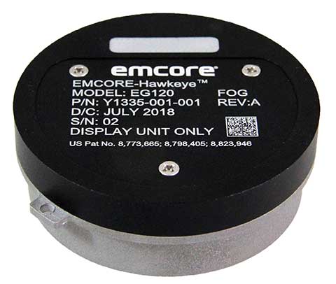
Fiber-optic gyroscope
For medium accuracy platforms
Photo: Emcore
The Emcore-Hawkeye series EG-120 FOG module is an ultra-compact, state-of-the-art design that is a small, affordable closed-loop FOG. The EG-120 delivers advantageous size, weight and power (SWaP) and is 35% smaller than Emcore’s previous generation FOGs. The Emcore-Hawkeye EG-120 incorporates advanced, next-generation field programmable gate array (FPGA) electronics that deliver increased performance and reliability combined with low cost. The Emcore-Hawkeye series features performance specifications for medium accuracy platform stabilization applications such as camera systems used in aircraft, unmanned aerial vehicles (UAVs) and gun stabilization systems. A wide variety of other guidance, navigation and aeronautics applications are supported. Emcore, www.emcore.com
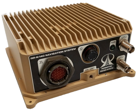
Navigation system
Customizable for ground vehicles of all sizes
Photo: Robotic Research
The RR-N-140 navigation system provides accurate, absolute and relative 3D localization information for ground vehicles of all sizes. It features dual-antenna GNSS for zero-speed heading detection and redundancy. The device delivers exceptional localization performance in GPS-denied or compromised areas. It is designed specifically for use on unmanned ground vehicles and is customizable to incorporate a wide variety of sensor inputs into the navigation solution. Robotic Research, www.roboticresearch.com
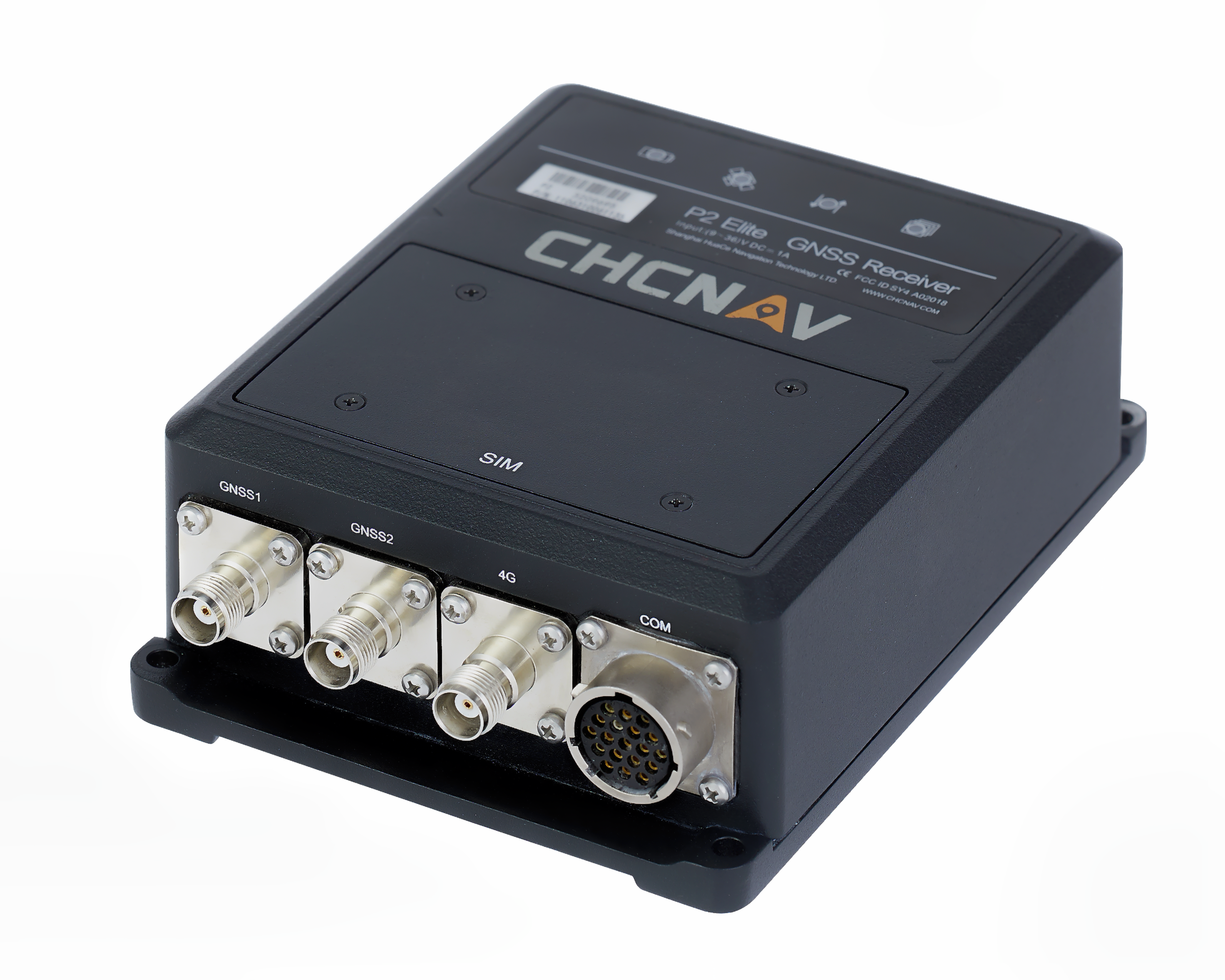
GNSS sensors
Combines numerous interfaces to speed system integration
The P2 Elite GNSS sensor. (Photo: CHC Navigation)
CHC Navigation’s new P2 GNSS sensor series provides high-accuracy positioning and heading in a compact, rugged enclosure. The series is suitable for a wide variety of applications such as reference stations, marine systems, unmanned navigation, industrial automation, robotics and machine control. The P2 GNSS series is designed to significantly reduce system integration efforts by combining numerous connectivity interfaces including RS232, low-latency PPS output, Ethernet, CAN bus protocol and a comprehensive web interface for configuration set-up. The series integrates the latest GNSS technology in a rugged IP67 and lightweight enclosure. It delivers reliable, uninterrupted, high-accuracy, real-time positioning and heading measurements. The P2 GNSS sensor offers cost-effective and powerful real-time kinematic (RTK) positioning. The P2 Pro GNSS adds a dual-antenna input for precise heading data. The P2 Elite integrates additional 4G and UHF modems to provide a powerful, all-in-one GNSS sensor. CHC Navigation, www.chcnav.com
TRANSPORTATION
Correction stream
Data enables precision positioning
RTX Auto is a GNSS software library for use in safety-critical automotive applications. The RTX Auto library can be integrated with any GNSS device and enables the decoding of Trimble’s RTX correction stream for centimeter-level absolute positioning accuracy. It works with other on-vehicle sensors to deliver a certified positioning solution that satisfies advanced driver assistance systems (ADAS) and autonomous driving requirements. It provides RTX-based absolute positioning for General Motors’ Super Cruise, a hands-free driving system for the freeway. After 2020, Super Cruise will will be available on all General Motors brands. Trimble, trimble.com
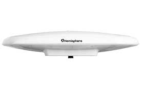
Smart antenna
Atlas-capable for marine markets
Photo: Hemisphere GNSS
The Vector V200 single-frequency, multi-GNSS smart antenna with integrated Atlas L-band is designed for general marine applications and markets. Powered by Hemisphere’s Crescent Vector technology, the V200 multi-GNSS compass system utilizes GPS, GLONASS, BeiDou, Galileo and QZSS (with future firmware upgrade and activation) for simultaneous satellite tracking to offer heading, position, heave, pitch and roll output. With support for NMEA 0183 and NMEA 2000, the V200 provides accurate position and heading information to autopilots, chart plotters and other general marine navigation applications. Hemisphere GNSS, www.hemispheregnss.com
Driver safety solution
Security for intelligent driving
The Proactive Security Solution for Intelligent Driving will enhance safety by supporting ADAS and driver monitoring systems (DMS). It integrates Quectel multi-mode LTE Cat 6 smart modules SC600Y/SC600T and an artificial intelligence (AI) algorithm from a third party to realize ADAS and DMS capabilities including monitoring irregular driving behaviors, conducting precise detection of vehicles and traffic signs, sending warnings of potential risks and more. For ADAS, it can precisely identify and locate vehicles, pedestrians, lanes and traffic signs and will send alerts to drivers if an imminent collision or an unintended lane departure is detected. The DMS supports facial recognition and detection, and is able to monitor driver attentiveness and measure eye blinks as well as head movements so that drivers will receive warnings of distractions, smoking, yawning or looking around. Quectel Wireless Solutions, www.quectel.com
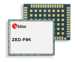
Automotive module
Aimed at urban lane accuracy
The ZED-F9K module is designed to keep cars in their lanes. (Photo: u-blox)
The ZED-F9K GNSS and dead-reckoning module brings continuous lane-accurate positioning to challenging urban environments. Building on the F9 platform, the module offers both high-precision multi-band GNSS and inertial sensors. It combines the latest generation of GNSS receiver technology, signal processing algorithms and correction services to deliver down to decimeter-level accuracy within seconds. The real-time kinematic (RTK) receiver module receives GNSS signals from all orbiting constellations. The inertial sensors constantly monitor changes in the moving vehicle’s trajectory and continue to deliver lane-accurate positioning when satellite signals are obstructed, such as in parking garages, tunnels, urban canyons or forested areas. The module’s accuracy and low latency make it suitable for automotive OEMs and Tier 1 automakers developing V2X (vehicle-to-everything) communication systems. By continuously sharing their location, V2X systems help increase overall road safety and reduce congestion. u-blox, www.u-blox.com
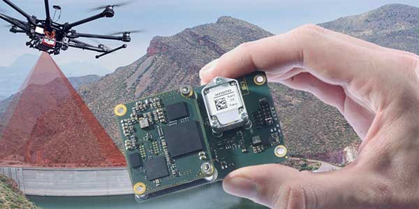
The Quanta UAV series is a line of inertial navigation systems (INS) dedicated to UAV-based surveying integrators. The small, lightweight and low-power INS is offered with two levels of accuracy. Quanta UAV and Quanta UAV Extra have been developed for compact lidar to high-end beyond-visual-line-of-site (BVLOS) mapping solutions. They provide precise orientation and centimeter-level position data both in real time and in post processing, eliminating the need for ground control points and reducing the need for overlaps. SBG’s post-processing software Qinertia gives access to offline real-time kinematic (RTK) corrections from more than 7,000 base stations in 164 countries. SBG Systems, www.sbg-systems.com
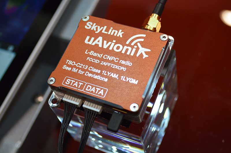
CNPC radio prototype
Being tested as command and non-payload control UAS radio
Photo: Allison Barwacz
SkyLink is an L-band frequency-modulated CNPC radio intended for point-to-point or networked BVLOS UAS operations. uAvionix has focused on minimizing size, weight, and power consumption (SWaP) while maximizing range and spectrum efficiency. The current 50-gram 10-Watt prototype is testing successfully at ranges exceeding 40 miles at low altitude. uAvionix is testing under an experimental transmit license and approval from the Federal Communications Commission and Federal Aviation Administration, respectively. uAvionix, uavionix.com
Thermal drone
Designed for solar farm inspections
The senseFly Solar 360 UAV is designed to enable the automated and efficient inspection of solar farms. Created in collaboration with software company Raptor Maps, the efficient thermal drone solution enables the automatic assessment of solar plant performance at a sub-module level. Created by combining eBee X fixed-wing drone technology, senseFly’s Duet T thermal mapping camera and Raptor Maps software, senseFly Solar 360 is a fast and fully automated drone. It can be integrated into solar management workflows without requiring either drone piloting skills or the manual analysis of aerial solar-farm data. Solar-farm inspection can be reduced from days to hours, with inspection of utility-scale solar farms completed more quickly, easily and accurately. SenseFly, www.sensefly.com Raptor Maps, raptormaps.com
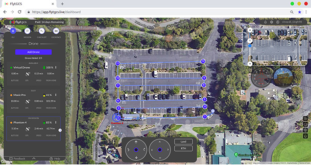
Remote operations
Cloud-based, enables BVLOS
Photo: FlytBase
FlytGCS is built for subject-matter experts, drone operations managers and UAV operators who wish to automate, simplify and scale their missions. To support automated BVLOS missions, FlytGCS offers features such as connectivity and control over 4G/LTE/5G, live high-definition video feed, fleet management, unlimited missions, remote gimbal control, pre-flight checklist and geofence, mission planner and cockpit view from a web dashboard. FlytGCS is a hardware-agnostic solution that helps securely deploy drones using a mobile app (for DJI drones) or onboard single-board computers (for Ardupilot and PX4 drones). FlytBase, flytgcs.live
Inspection drone
Collects data in dangerous areas
The Elios 2 is a collision-tolerant drone for indoor inspections. (Photo: Flyability)
The Elios 2 UAS is designed for inspection tasks. Routine inspection jobs indoors, underground and around complex pipework become quicker, safer and are fully documented by high-resolution video and stills. The Elios 2 includes a rotatable thermal and high-definition visual camera payload, 10,000-lumen oblique lighting system, and reversible rotors that enable the UAV to back out of tricky situations. The drone’s geodesic-like cage makes it collision-tolerant and enables flight in restricted areas such as refinery enclosures, mines, vats, cargo holds and nuclear containment vessels. Flyability, www.flyability.com
SURVEY
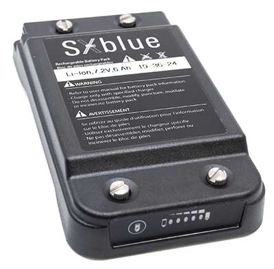
Battery upgrade
Long-life battery for extended fieldwork
Photo: Geneq
SXblue receivers now have an extended-life battery equipped with 4 Li-ion rechargeable cells that boost its capacity from 3900 mAh to 6000 mAh. When fully charged, the battery can last up to 16 hours depending on the SXblue model and Bluetooth connectivity — an up to 50% increase. The colored LEDs for the battery charge indicator have been enhanced for a better contrast. With only a 6-mm increase in thickness and the same weight as previous models, the user will not notice any change in handiness and ergonomics. The new battery is compatible with all past SXblue II and III models and current iSXblue II+ GPS, SXblue II+ GPS, iSXblue II+ GNSS, SXblue II+ GNSS and SXblue Platinum. Geneq, geneq.com
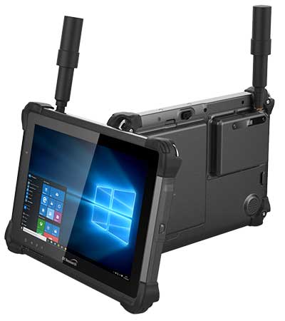
Fieldwork tablet
Captures detailed images
DT301X-TR rugged tablet. (Photo: DT Research)
The DT301X-TR rugged tablet includes an Intel RealSense 3D camera. The lightweight military-grade tablet is built to enhance precision for bridge and construction inspections, 3D surveying and mapping of underground utilities. It provides multi-frequency GNSS real-time kinematic (RTK) with carrier phase for mapping and positioning, and supports GPS, GLONASS, BeiDou, Galileo and QZSS. An optional foldable antenna supports high-accuracy field work, which can be measured with RTK GNSS positioning directly or used to connect to an external antenna for higher precision. DT Research, www.dtresearch.com
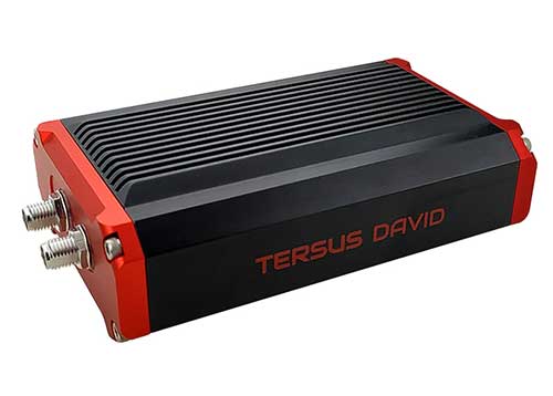
GNSS Receiver
Dual-antenna receiver with heading
Photo: Tersus GNSS
The David Plus dual-antenna GNSS receiver offers centimeter-accurate positioning and heading for intelligent transportation, construction, machine control, precision agriculture and navigation. Designed for efficient and rapid integration, the compact, lightweight receiver tracks GPS, GLONASS and BeiDou signals: GPS L1/L2, GLONASS L1/L2, BeiDou B1/B2 from the primary antenna, and GPS L1/GLONASS L1 or GPS L1/BeiDou B1 from the secondary antenna. The modular and flexible design can provide robust positioning and heading accuracy in a compact footprint for UAVs and other smaller autonomous projects. Tersus GNSS, www.tersus-gnss.com
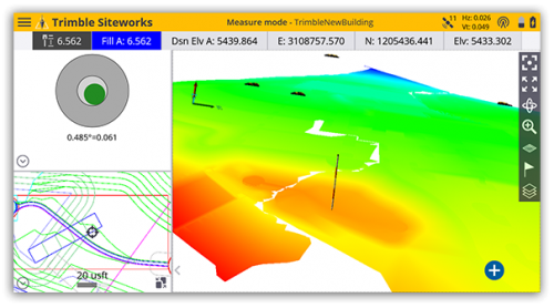
Tilt compensation
Android and Windows compatible
Screenshot: Trimble
Siteworks Software version 1.1 features GNSS tilt-compensation functionality and support for the Android operating system, meaning field workers can use smartphones or tablets. Contractors can run Siteworks on either Windows 10 or Android. Using Trimble Siteworks and a Trimble SPS986 GNSS smart antenna, construction surveyors can take measurements faster and perform more efficient stakeouts. It is designed to shield magnetic interference and can be used effectively anywhere on a construction site. Construction surveyors can capture accurate points without leveling the pole. Three modes support tilt compensation, so contractors can record accurate points while standing, walking or driving the site in a vehicle. Trimble, www.trimble.com
RTK receiver
Multi-band centimeter-accuracy
Photo: Emlid
The Reach RS2 is a multi-band GNSS receiver that features a built-in LoRa radio, a 3.5G modem, and a survey app for iOS and Android. The receiver determines a fixed solution in seconds and provides positional accuracy down to several millimeters. It tracks GPS/QZSS (L1, L2), GLONASS (L1, L2), BeiDou (B1, B2), Galileo (E1, E5) and SBAS (L1C/A), and reliably works in RTK mode on distances up to 60 kilometers and 100 kilometers in PPK mode. A multi-feed antenna with multipath rejection offers robust performance even in challenging conditions. RINEX raw data logs are compatible with OPUS, CSRS-PPP, AUSPOS and other PPP services so users can now get centimeter-precise results. Emlid, emlid.com
Mapping
High-speed camera
High resolution for aerial imaging
Photo: Teledyne
The Falcon 4 is a 86-megapixel ultra-high resolution and high-speed complementary metal oxide semiconductor (CMOS) camera. It offers capabilities for large-area, high-resolution, high-speed imaging. With 86 megapixels at 16 frames per second and a global shutter, the camera offers capabilities for large-area, high-resolution, high-speed imaging. Available in both color and monochrome models, the camera is sensitive into the near-infrared spectrum. The Falcon4’s high resolution and throughput serve a
variety of challenging applications including aerial imaging, reconnaissance, security and surveillance, 3D metrology and flat panel display inspection.
Three new high-performance lenses are designed for high-altitude aerial photography and long-range aerial and ground inspection applications. The 300mm AF, 180mm, and 150mm MK II lenses are designed to enhance the performance and flexibility of Phase One Industrial’s iXM-RS and iXM aerial camera series. Each offers precision imagery, taking advantage of the cameras’ ultra-high resolution backside-illuminated CMOS sensors, to maintain a smaller ground sample distance while flying at higher altitudes.
The SORA-P60L, part of Cepton’s SORA family of lidar scanners, is purpose-built to deliver long-range, high-resolution imaging for UAVs. It offers a 400-Hz frame rate, enabling drones to fly faster while maintaining high point-cloud density. With a 550-gram payload, the SORA-P60L prolongs UAV flight time allowing more ground to be covered in a single trip. Cepton’s Micro-Motion Technology faces all lasers downward at all times, providing a dense, uniform point cloud that, in combination with the high scan rate, makes it suitable for fixed-wing and fast-moving rotary-wing UAVs.
The WASP-200 LRF rangefinder is designed to measure ranges with accuracy and precision. It can be used for precision agriculture applications and as a proximity-to-ground sensor on board small or large unmanned aerial vehicles. It has 1-centimeter resolution and 10-centimeter accuracy, and is compatible with the Collins Aerospace Piccolo (CAN Bus and RS-232) and Pixhawk drivers. The WASP series of rangefinders also feature single-shot laser ranging for fast scanning and moving platforms; programmable burst mode averaging; and an IP-67 option. The rangefinders are suitable for robotics and UAVs, sense and avoid, industrial automation, height and distance measurements, and maritime operations.
The Leica BLK2GO is a small, portable, integrated handheld imaging scanner that offers mobility for scanning complex indoor environments. It combines visualization, lidar and edge-computing technologies to scan in 3D while in motion, allowing users to be more agile and efficient in capturing objects and spaces. Its dual-axis lidar scans up to 700,000 points per second. The handle contains WLAN connectivity, a rechargeable 45-minute battery, data storage for six hours of scans, a USB-C port for fast data transfer, and edge computing. The BLK2GO has a wide range of applications from adaptive reuse projects in the architecture and design industries to location scouting, pre-visualization, and VFX workflows for media and entertainment.
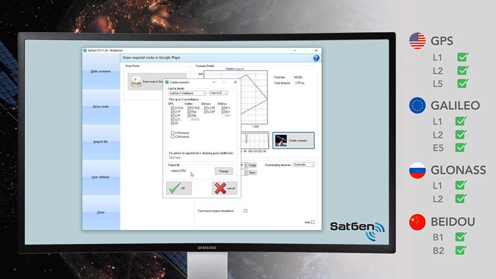
Racelogic Ltd. has released the latest update to its SatGen GNSS simulation software for PC, which now incorporates Galileo RF simulation.
Designed to create a GNSS RF I&Q or IF data file based on a user-generated trajectory file, the updated software can now accurately simulate the European Galileo GNSS satellite constellation alongside existing GPS, GLONASS and BeiDou RF signal generation.
The full range of Galileo frequencies that SatGen can simulate are Galileo E1 B/C, E5a, E5b and E6 B/C (see below for details).
SatGen 3.11.39 Galileo simulated RF frequencies
Galileo E1 B/C. Transmitted by all Galileo satellites on the E1 (1575.42 MHz) frequency, same as GPS L1. Standard precision Open Service signal consisting of Data component B and Pilot component C.
Galileo E5a. Transmitted by all Galileo satellites on the E5a (1176.45 MHz) frequency, same as GPS L5. Open Service signal consisting of Data component I with the F/NAV navigation message and Pilot component Q. Intended to be used together with E1 B/C to improve accuracy.
Galileo E5b. Transmitted by all Galileo satellites on the E5b (1207.14 MHz) frequency, same as BeiDou B2. Open Service signal consisting of Data component I with the I/NAV navigation message and Pilot component Q. Intended to be used together with E1 B/C to improve accuracy.
Galileo E6 B/C. Transmitted by all Galileo satellites on the E6 (1278.75 MHz) frequency. High accuracy Commercial Service signal consisting of Data component B and Pilot component C. Because the content of the C/NAV navigation message is encrypted, SatGen transmits a dummy navigation message, which should be accepted by all receivers.
“Given the vast improvements in navigation and timing that Galileo has brought to its global users, we extremely excited to be releasing a version of SatGen that allows engineers to generate Galileo-specific scenarios for their test procedures,” said Mark Sampson, LabSat product manager.
Other changes to the software include various user interface tweaks, performance optimization and fixes.
For more information on SatGen, contact Katie Harland or call Racelogic LabSat at +44 1280 823 803.
SiTime Corp. has unveiled its Endura micro-electro-mechanical system (MEMS) timing solutions for aerospace and defense applications including precision GNSS, as well as field and satellite communications, avionics and space.
The Endura products are engineered to provide high performance in harsh conditions — severe shock, vibration and extreme temperature — that are routinely experienced in these applications.
SiTime offers customers 5 million possible part numbers that can be created from 17 programmable products.
“When exposed to high levels of shock, vibration, and extreme temperatures, legacy timing components have been prone to failure, degrading system performance and reliability,” said Piyush Sevalia, executive vice president of marketing. “To solve these problems, SiTime created an oscillator system of silicon MEMS, analog circuits, compensation algorithms, and advanced packaging, which is designed to outperform any other available timing solution in harsh environments.
“For example, Endura precision TCXOs deliver 4 parts per trillion per g (ppt/g) of acceleration sensitivity, which is 50 times better than legacy quartz-based solutions. With such performance, we believe that Endura will transform the oscillator landscape in aerospace and defense.”
Highlights of the company’s solutions include:
4 parts per trillion per g force of acceleration (50 times better than quartz)
Supports –55 degreesCelsius and +125 degrees Celsius operation
Key timing specifications conform to MIL-PRF-55310
Five million possible part numbers
Endura Super-TCXOs (temperature compensated oscillators) for use in high-speed communications and GNSS applications include:
SiT5146/SiT5147 – 1 to 220 MHz, ±0.5 to ±2.5 ppm, -40 degrees Celsius to +105 degrees Celsius
SiT5346/SiT5347 – 1 to 220 MHz, precision ±0.1 to ±0.25 ppm, -40 degrees Celsius to +105 degrees Celsius
SiT5348/SiT5349 – 1 to 220 MHz, ultra-precision ±0.05 ppm
SiTime’s portfolio of commercial off-the-shelf (COTS) Endura products spans six oscillator types and 17 products. All devices offer programmable options such as frequency, operating voltage and stability.
In addition, some devices offer specialized programmable features such as spread spectrum, pull-range, and differential output type.
Endura products are available with up to two grades of acceleration sensitivity, as low as 4 ppt/g (typical). This breadth of products provides customers with a large selection and the ability to configure each device for their application requirements.
Endura products are also designed for continuity of supply for long-life programs.
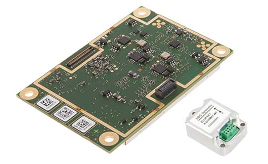
High-precision GPS/INS receiver is now available with a single-antenna option for faster integration, lighter weight and lower power consumption.
Photo: Septentrio
Septentrio’s GPS/INS receiver is now available with a single-antenna option. The single-antenna receiver brings the possibility of robust centimeter positioning and 3D attitude (heading, roll, pitch), while keeping weight and power consumption to a minimum. For Septentrio customers, this means simplified integration as well as increased operation time and productivity.
Septentrio centimeter-level positioning is based on multi-frequency, multi-constellation GNSS (GPS, GLONASS, Galileo, BeiDou, QZSS) technology. AsteRx-i S combines GNSS and an industry-grade inertial measurement unit (IMU) to deliver precise positioning together with 3D attitude and coasting functionality.
Septentrio’s unique GNSS/IMU integration algorithm enables continuous positioning in difficult environments such as near high structures, under foliage or during short GNSS outages (this is referred to as coasting or dead reckoning).
This makes AsteRx-i S a suitable positioning solution for robotics, autonomous vehicles and logistics. Previously available only as a dual-antenna product, AsteRx-i S is now available with either a single- or a dual-antenna option.
“By strengthening our GPS/INS integration portfolio we continue building upon our strategy of bringing reliable precise positioning together with 3D attitude to challenging industrial environments such as container parks or tree plantations,” said Danilo Sabbatini, product manager at Septentrio.
“AsteRx-i S has now become even more versatile with the support of both single and dual antenna operations on the same hardware platform,” Sabbatini said. “With the single-antenna AsteRx-i S delivers accurate 3D attitude in small-size applications where weight and power consumption are critical, while the dual antenna option is still the best solution for applications requiring short initialization time.”
Small, light, low power. The single-antenna AsteRx-i S requires minimal space which makes it suitable for robotic devices looking for small and light precise positioning solutions. Since only one antenna is required, there is less weight and lower power consumption, resulting in extended battery life. The dual antenna AsteRx-i S, on the other hand, is the best solution for devices requiring quick heading initialization and devices with prolonged static operation.
Advanced Interference Mitigation. AsteRx-i S comes with built-in Advanced Interference Mitigation (AIM+) technology. In robotic devices neighboring electronics can emit electromagnetic radiation which interfere with GNSS signals. AIM+ offers protection against such interference resulting in faster set-up times and robust continuous operation. A built-in power spectrum plot allows users to analyze interference, helping locate its source and mitigating it.
By offering both single and dual antenna options, Septentrio is now able to better accommodate specific needs of their customers interested in a GNSS/INS solution.
With tariffs, trade wars and sanctions ruling the day, how is a self-respecting UAS manufacturer supposed to make a buck? And to whom are the manufacturers of defense UAS able to sell their wares?
To NATO and other friendly countries, comes the ready answer, but there may still be a problem selling drones with armaments and offensive capabilities. Another layer of governmental review could swing into action when a company wants to sell to friendly countries like Saudi Arabia or perhaps to allies within the old Russian USSR block.
Last year, General Atomics lost sales to Saudi Arabia and the United Arab Emirates (UAE) for Predators and/or Reapers, large-bodied medium-altitude, long-endurance unmanned aircraft systems (or MALES). The deal went instead to a competing Chinese outfit. General Atomics complained bitterly about the loss of this business, which it blamed on restrictive U.S. export rules. The Administration responded by apparently loosening the regulations, in fact easing the way for most international sales. In response, it is possible that UAV manufacturers have also undertaken some changes which make U.S. drones even more competitive for export.
Business matters appear to have improved significantly. In May this year, the State Department actually used emergency provisions within the Arms Control Act to bypass Congressional review of a proposed sale to Saudi Arabia, UAE and Jordan of a package of Insitu Blackjack drones and launchers, worth $80 million.
The competition for world-wide sales of U.S. UAS products is increasingly tough, especially against Chinese suppliers with equivalent or perhaps less capable mil-spec drones. Hence the export rule changes which now appear to be working in the right direction.
Chinese Drones in the U.S.
Meanwhile, in an effort to accommodate U.S. concerns about the potential for user data somehow “leaking” to DJI — the Chinese supplier of almost 75% of U.S. drone purchases — DJI has implemented a “Government Edition” which apparently addresses the risk of data loss.
When US-based 3D Robotics stopped supplying 3DR Solo drones, the Interior Department found itself in a bind, as it had already bought hundreds of these devices for its inspection/surveillance operations. As the department searched for a new source for UAVs, it came to the conclusion that U.S. supplied drones were much less capable or up to ten times more expensive than equivalent DJI units. So they began working with DJI to solve the issue with potential data loss, and went on to test the results extensively
Working with the U.S. Interior Department for over 18 months, DJI has equipped drones and their controllers with modified hardware and custom software that ensure that the drones only operate in local data mode: information collected in flight is stored on the UAV alone and must be manually downloaded after flight. The drone is actually loaded with custom software by the user prior to flight to ensure this mode of data collection.
Even with these modifications, for now the use of DJI drones is still restricted to non-sensitive applications.
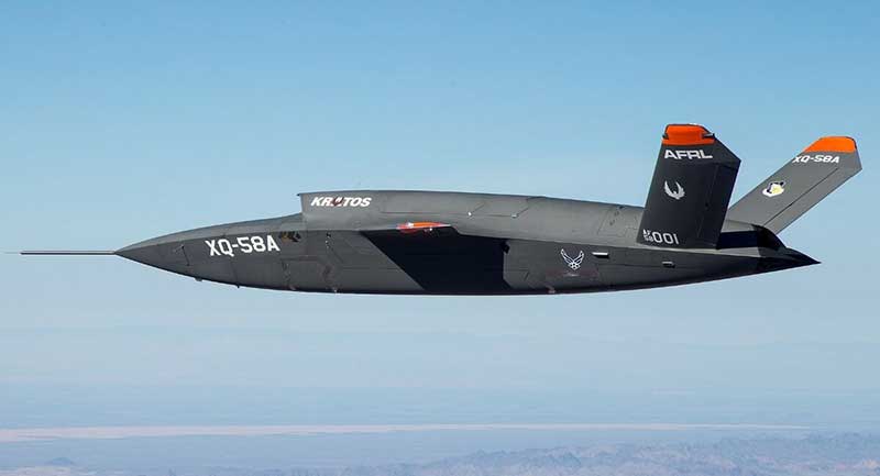
USAF/Kratos XQ-58A
The XQ-58A Valkyrie demonstrator, a long-range, high subsonic UAV completed its inaugural flight March 5, 2019, at Yuma Proving Grounds, Arizona. (Photo: U.S. Defense Department)
Kratos is working with the U.S. Air Force to develop a jet-powered UAV system that can fly alongside manned fighter aircraft to multiply their effectiveness. At much lower cost than manned aircraft, the concept appears to be that more risk can be taken with the ‘loyal wingman’ UAVs to not only support the mission of the attack aircraft, but to also keep it safe.
We reported earlier on the XQ-58A after its first flight in March of this year. Now the Valkyrie is back in the flight test program with its second flight lasting 71 minutes over the Yuma test range on June 11. In the long- erm, it is hoped that both ground controllers and flight crew would operate these extensively autonomous drones.
A parallel “Skyborg” program is also underway to develop the hardware and artificial intelligence software capability to enable this type of drone to fly and fight alongside manned aircraft.
In conclusion, trade wars and tariffs aside, let’s hope that good UAV products can still make headway on their merits alone.
Collins Aerospace Systems, a unit of United Technologies Corp., has begun taking orders for its latest-generation Miniature PLGR Engine – M-Code (MPE-M) GPS receiver set for 2020 production deliveries.
According to independent testing, the MPE-M is the lowest size, weight and power (SWaP) small Type II form factor ground receiver available and incorporates the company’s recently certified Common GPS Module (CGM).
As a drop-in replacement for the thousands of customers using Collins’ Miniature PLGR Engine-SAASM (MPE-S) GPS receiver, the new MPE-M technology provides ten-times stronger anti-jamming capabilities for the direct acquisition of GPS signals than its predecessor.
The MPE-M is capable of receiving the current military Y-Code GPS signal along with the newer Military Code (M-Code) signal. For all GPS signals, the MPE-M provides warfighters improved security and assured positioning, and it satisfies the U.S. government’s requirement for all military GPS equipment to be M-code-capable.
“The MPE-M is ideal for lightweight, ground-based applications such as radios, blue force trackers, targeting devices, vehicle LRUs and small unmanned aircraft,” said Troy Brunk, vice president and general manager, Communication, Navigation and Electronic Warfare Systems for Collins Aerospace. “The implementation of M-code will provide our warfighters with increased mission effectiveness and safety due to the improved reliability of the signal.”
Collins Aerospace is currently the only military GPS receiver provider that manufactures its products in house, assuring control over quality and delivery schedules. The MPE-M’s security certification also makes the receiver eligible for export to U.S. allies through the Foreign Military Sales (FMS) program.
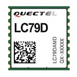
Quectel Wireless Solutions has launched a compact dual-band GNSS module, the LC79D, that supports the L1 and L5 bands from navigation satellites to improve positioning accuracy.
Featuring concurrent multi-constellation GNSS receivers on dual GNSS bands, LC79D uses L1 and L5 bands for GPS, Galileo and QZSS satellites, L1 band for GLONASS and BeiDou satellites, and L5 band for IRNSS satellites.
Compared to GNSS modules that use the L1 band only, LC79D can generally increase the number of visible satellites, significantly improve positioning drifting when driving in rough urban canyons and enhance positioning accuracy.
Embedded with a low-noise amplifier (LNA) and multi-tone active interference, the module provides higher sensitivity and reliable anti-jamming capability, ensuring exceptional acquisition and tracking performance even in weak signal areas. Multiple communication interfaces including UART and SPI simplify customer designs and accelerate time-to-market for customers’ products at reduced costs.
With dimensions of 10.1 × 9.7 ×2.4 millimeters, the tiny LC79D meets the requirements of size-sensitive applications. Compact design, low power consumption and high performance make it suitable for vehicle, people and asset tracking as well as sharing economy applications.
“The launch of LC79D shows Quectel’s global leading position to provide positioning modules for applications requiring higher accuracy and reliability, especially in rough environments with weak signals,” said Wang Min, automotive and GNSS product director at Quectel. “LC79D gives customers high-level integration and flexibility to realize precise positioning in real time.”
The LC79D module was showcased at MWC Shanghai 2019 during June 26-28.
Mosaic is Septentrio’s most compact, next-generation, high-precision multi-frequency GPS/GNSS module. The receiver brings precision and reliability of high-end multi-frequency GNSS to mass-market applications, the company said. It is designed to fit into the assembly-line process, which allows mosaic to be favorably priced for high volumes.
Its lightweight and low power consumption helps extend the battery life of robotic devices, increasing operation time and efficiency. This makes mosaic suitable for applications such as robotics, automation, telematics and wearables.
“We see a growing demand for reliable high-precision positioning,” said Chris Lowet, product manager at Septentrio. “A few years ago, this demand was concentrated in professional applications, for example survey, high-precision mapping and machine control. Today, with expansion of robotics, automation and IoT, a wide range of devices need high-precision positioning, from ag robots to IoT gateways to autonomous vehicles. We designed mosaic to answer these market needs.”
Highlights of mosaic include:
Centimeter positioning in tough environments with multi-frequency, multi-constellation GNSS technology
Extensive corrections support for high-accuracy positioning: SBAS, PPP, SSR, RTK
RAIM+, integrity engine needed for safety-critical applications such as autonomous vehicles
Tracking all current and future GNSS satellite signals for enhanced real-time kinematic (RTK) performance and guaranteed RTK network compatibility
100-Hz update rate, suitable for robotics and fast-moving vehicles.
The development kit assists Septentrio customers with integrating mosaic into their system. It supports connectivity through internet, COM ports, USB 2.0 as well as an SD Card slot. The development kit can be requested here.
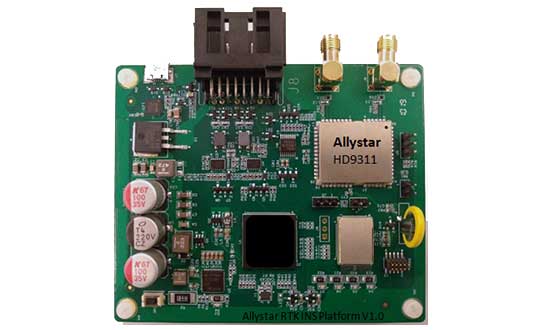
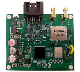
The Allystar INS Platform — the company’s latest technology — is a dual-antenna, multi-frequency, multi-GNSS inertial navigation system (INS) that delivers accurate and reliable position, velocity and orientation, the company said.
It is designed for a wide range of autonomous vehicle applications under the most demanding conditions.
The Allystar INS Platform combines high-grade, six-axis, temperature-calibrated accelerometers and gyroscopes with a multi-frequency, multi-GNSS engine, the HD9300 series. HD9300 is a dual-antenna chip-grade real-time kinematic (RTK) GNSS receiver for accurate positioning and heading.
GNSS-aided inertial navigation systems are widely used in autonomous vehicles. However, high-accuracy multi-frequency multi-GNSS receivers are usually too expensive for mass-market applications. The Allystar HD9300 series is a mass-market multi-band chip-grade receiver that concurrently support all civil bands in all GNSS constellations (GPS/QZS L1&L2&L5&L6, BDS B1&B2&B3, GAL E1&E5, GLO L1OF/L2OF) with an integrated RTK engine to achieve centimeter-level accuracy.
The Allystar INS platform contains an on-board sensor-fusion filter, navigation and calibration algorithms for different dynamic motions of land vehicles. Key features include:
multi-band multi-GNSS chip-grade receiver
dual antennas
integrated RTK engine (up to 2 centimeters)
100-hz update rate
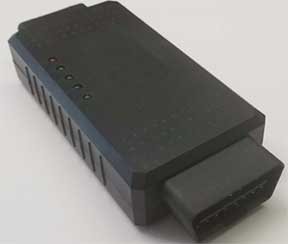
OBD data adapter.
Allystar OBD Data Adaptor V1. (Photo: Allystar)
The Allystar OBD Data Adapter (v1.0) enables users to read and monitor various sensors built into cars, obtaining the real-time vehicle speed and gear signals from the OBD interface, and then output AT commands by serial port or SPI. When connected to the Allystar RTK INS platform, the adapter allows for outstanding navigation accuracy, especially in urban areas, helping to increase accuracy and reduce position drift.
An evaluation kit — including platform board, antenna and OBD adaptor — will be available in August.
Protection from jamming has emerged as the key concern of of both national and organizational/corporate infrastructures. The world abounds in bad actors, and systems based on GNSS signals are uniquely vulnerable. A basic component of any anti-jamming (AJ) strategy is a shielded antenna. An upcoming webinar, June 27, gives a primer and several advanced looks at developing such an antenna-based AJ campaign. Register here for the complimentary webinar.
Anti-jam antennas use techniques, such as nulling or beam-forming, to mitigate the effects of interfering signals. (Image: Orolia)
Controlled reception-pattern antennas (CRPAs) are advanced, multi-element antenna solutions that protect a GNSS/GPS receiver from jamming sources. When combined with antenna electronics, they form an anti-jam antenna system (AJAS). These systems utilize several available technologies and vary in the number of elements.
CRPAs will play an increasing role in the GPS/GNSS landscape. Initially developed in the military domain, they are now entering the civilian market and are poised to bring their benefits to the fields of aerospace, ground transportation, autonomous driving and others. Engineers working with GNSS systems that employ CRPAs and multi-element antennas need special test systems since they need to replicate very specific test conditions that are impossible with live signals.
These complex antenna systems require advanced GNSS simulation equipment in order to be designed and validated, as well as to test their performance. These test systems come in two forms — an anechoic chamber system used to test the CRPA antenna over the air, and a wavefront simulator used to test the antenna electronics with a direct cable connection.
Webinar speakers:
Perdue
Lisa Perdue, Product Manager, Orolia. Perdue is an expert in testing critical GPS and GNSS systems. She has trained hundreds of engineers and technicians who are responsible for high-reliability positioning, navigation and timing applications. She took a lead role in the development of the first GNSS Vulnerability Test System and speaks widely on the topic at many industry conferences.
Hamel
Stéphane Hamel, Director, Testing, Orolia. With a career spanning more than 20 years in engineering test and RF, Hamel has developed many innovative and large-scale products to test semiconductor devices, radios and GNSS receivers. In 2014, he founded Skydel, now part of Orolia. Hamel is one of the architects behind the Skydel SDX GNSS simulator.
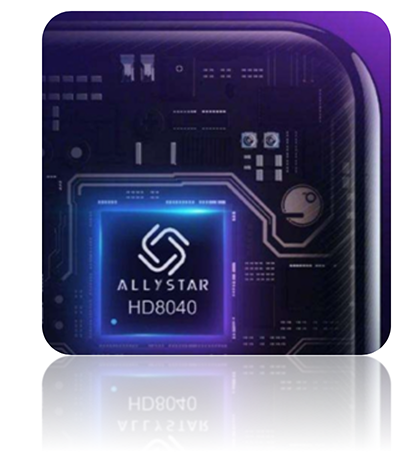
The latest Lenovo smartphone offers dual-frequency GNSS capable of tracking the latest BDS phase III signal, the Z6 SE, using an Allystar chipset.
The company says this is the first time a smartphone supports the new BeiDou signal.
HD8040 series SoC. (Photo: Allystar)
Fitted with a Allystar HD8040 series chipset, the Lenovo Z6 youth edition provides position accuracy up to sub-meter, according to Allystar.
The HD8040 series chipset supports all civil signals on the L5 band. Besides GPS/QZS L5 and GAL E5a, the latest BDS phase III signal B2a has already been implemented to maximize the visible satellites in L5 band.
Dual-frequency GNSS means that the receiver tracks more than one radio signal from each satellite on different frequencies — GPS L1 and L5, Galileo E1 and E5a, and Beidou B1 and B2a.
B2a will replace B2I and broadcast on MEO and IGSO satellites. The code lengths are 10230, which have better anti-cross-correlation performance and are designed separated pilot component and data component to improve tracking sensitivity.
In general navigation scenarios, multipath error lead to positioning inaccuracy of up to several meters, caused by to signals bouncing off of higher buildings. The error caused by multipath can be nullified and mitigated by using two frequencies instead of one in urban areas. Under a relatively open-sky environment, measurement error caused by the ionosphere is usually eliminated by a linear combination of dual frequencies to easily achieve sub-meter accuracy.
“Allystar is glad to boost the smartphones and Internet of Things (IoT) applications with the latest multi-frequency GNSS SoC (system on chip) technology,” said Shi Xian Yang, the product and marketing manager in Allystar.
Lenovo smartphone Z6 SE has Allystar inside. (Photo: Lenovo/Allystar)