On April 6, the GPS system used by many organizations for critical infrastructure will perform a rollover. The rollover is the result of a legacy GPS navigation message which gives a week number as a 10-bit parameter.
As a result, the week number parameter in the GPS navigation message needs to reset to zero every 1024 weeks. That means from that date onwards, users are likely to start seeing rollover problems in GPS receivers that aren’t programmed to cope with the week number reset.
Meinberg, a GNSS receiver maker based in Germany, has a different approach with its GPS receivers. Instead of a 10-bit parameter, Meinberg’s firmware uses a 16-bit week number, and it is incremented at the end of each week.
This means that by the first rollover on Aug. 21, 1999, the week number sent by the satellites rolled from 1023 back to 0, while the internal (Meinberg) week number simply counted to 1024, then to 1025 and so forth. So, on April 6, the GPS week counter will reset to 0, but Meinberg’s internal one, which will have been reached the value of 2047 by that time, will continue to count in a consecutive order.
More information about the GPS Week Number Rollover can be found on our Meinberg’s Knowledge Base.
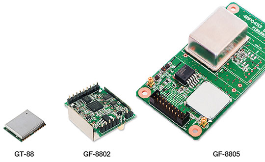
Furuno Electric Co. Ltd., based in Nishinomiya, Japan, has developed the GT-88 timing module and GF-8801/02/03/04/05 disciplined oscillator for users who require UTC time-synchronized signals to meet the new 5G requirements.
They provide UTC time-synchronized timing signals (1 PPS/10 MHz) by receiving GNSS satellite signals. Achieved stability is better than that of an atomic clock, including a rubidium.
Photo: Furuno
The GT/GF-88 series includes a brand-new algorithm, named Dynamic Satellite Selection, that provides outstanding multipath mitigation, especially in urban canyon environments, the company said. The algorithm was developed by Nippon Telegraph and Telephone Corporation (NTT) based in Tokyo, Japan.
Extremely high stability of 4.5 ns (1 sigma) is obtained, only requiring reception of the L1 band (1575.42 MHz) frequency GNSS satellites. It was achieved by improving advanced position estimation algorithms and optimizing position calculation among several different GNSS satellite constellations. It allows users to achieve 5G-required performance without any changes to existing single-band GNSS antennas.
It incorporates the Dynamic Satellite Selection, an advanced multipath mitigation algorithm developed by NTT. Normally typical time synchronization performance deteriorates in urban canyon environments by the effect of multipath. The Dynamic Satellite Selection reduces this time error by one-fifth. This provides more flexibility when installing GNSS antennas. Consequently, the GT/GF-88 series now permits GNSS antennas to be mounted on walls, windows of tall buildings and other difficult reception environments.
The GT/GF-88 series continues to support GPS, GLONASS and QZSS satellite constellations, and now adds Galileo support. As the total number of satellites available increases, operational stability also increases.
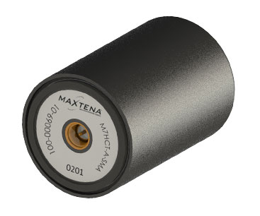
Maxtena Inc. has introduced a patented GNSS antenna designed for high-precision and autonomous multi-frequency applications. The M7HCT-A-SMA antenna is a high-accuracy, multi-frequency active quadrifilar helix GNSS antenna.
Photo: Maxtena
Maxtena is a U.S.-based antenna design and manufacturing company and inventor of the patented Dynamic Aperture Technology.
The new design will offer concurrent GNSS reception on L1: GPS, GLONASS, Galileo, Beidou and L2: GPS L2C, Galileo E5B and GLONASS L3OC in a rugged, compact and ultra lightweight form factor.
The antenna is designed for GIS, RTK and other high-accuracy GNSS applications such as the drone and automotive markets, where high performance and low weight are driving features in antenna selection.
The M7HCT-A-SMA active helix design features Maxtena’s patented compact and lightweight Helicore technology. This technology provides exceptional pattern control, polarization purity and high efficiency in a very compact form factor.
The antenna offers up to 30-dB gain for GNSS applications that utilize GPS, GLONASS, Galileo and Beidou, in one radome housing with a single SMA connector.
The M7HCT-A-SMA will join Maxtena’s line of rugged GNSS helix antennas that are ultra lightweight, small, and precise. The M7HCT-A-SMA weighs 25 grams and is housed in automotive grade PCB plastic with automotive grade electronics and is rated IP67 when mounted.
It is ground plane independent and offers extremely low power consumption and minimal phase-center variation over azimuth. The antenna offers superb axial ratio ensuring multipath error is mitigated.
“Maxtena is very excited to be launching a game-changing antenna for the UAV, drone, and automotive markets, and really for any application requiring a high performance, lightweight antenna that can cover so many frequencies. It is the most robust antenna solution on the market,” said Maxtena Vice President of Sales and Marketing Vanja Maric.
Norway has electronic proof that Russian forces disrupted GPS signals during recent NATO war games, according to a report in Reuters news service.
The Scandinavian country and North Atlantic Treaty Organization (NATO) member has demanded an explanation from its neighbor. “We recognize Russia’s right to exercise and train its capacities [but] it is not acceptable that this kind of activity affects security in Norwegian air space,” stated the Norwegian defense ministry.
Finland and Norway published claims in November that Russia may have intentionally disrupted GPS signals before and during NATO military exercises. The radio-frequency interference also affected the navigation of civilian air traffic in the Arctic. Both countries protested to Russia, which dismissed the allegations.
“We gave them the proof,” Norwegian Defence Minister Frank Bakke-Jensen stated publicly. Russia demurred, with Foreign Minister Sergey Lavrov terming the Norwegian allegations “a fantasy,” and said it would conducts its own investigation. “To be a neighbor of Russia you need to be patient,” added Bakke-Jensen.
Could Russia have targeted Norway intentionally? The minister replied: “They were exercising very close to the border and they knew this will affect areas on the other side.”
November saw NATO’s largest exercise in decades, involving forces from 31 countries in an area stretching from the Baltic Sea to Iceland.
Above: Krasukha jammer mounted on a heavy-duty truck, part of the radio electronic warfare unit (EW) of the Western Military District. (Photo: Ministry of Defense of the Russian Federation)
NovAtel’s Waypoint Products Group has released version 8.80 of its GNSS and GNSS+INS post-processing software products, including Inertial Explorer, Inertial Explorer Xpress, GrafNav and GrafNet. All Waypoint customers with an active subscription that are within the support period qualify for the Waypoint 8.80 upgrade at no additional charge.
Key features of the 8.80 release include:
High-rate precise satellite orbit and clock corrections available in minutes with the TerraStar-NRT option
Increased accuracy for pedestrian and vehicle applications by applying vehicle constraints using our SPAN intelligent vehicle dynamics modelling
Ability to use L5, E5a, B3 in differential solutions
14 percent faster processing with 64-bit support
For applications requiring highly accurate post-mission position, velocity or attitude, post-processing maximizes the accuracy of the solution by processing previously stored GNSS and inertial measurement unit (IMU) data forward and reverse in time, and combining the results. The position, velocity and attitude solution can be smoothed and output at the required data rate and in the coordinate frame required. This process also provides the ability to assess the solution reliability and accuracy.
The GrafNav and Inertial Explorer software packages are available as a digitally secured machine-portable license. The products are also available as a perpetual license or as a time-limited term license. A Software Development Kit (SDK) is available to allow developers to customize the entire processing workflow to suit their customers or application.
The Waypoint process:
Step 1: Capture raw GNSS and IMU data.
Step 2: Waypoint post-processing software maximizes the accuracy of the solution by independently processing data forward and reverse in time and combining the results.
Step 3: The position, velocity and attitude solution is smoothed to deliver an unparalleled level of accuracy. In-depth quality analysis tools verify the quality of the trajectory.
Step 4: Export your results at the required data rate and in the coordinate frame required.
Polaris Wireless, a provider of software-based wireless location solutions, announced the commercial availability of a high-accuracy carrier-independent 3D location platform for application developers. By integrating their applications to the new platform, developers can provide end users with pinpoint location, including indoors and in high-rise buildings with floor level accuracy, delivering enhanced situational awareness and improved operational efficiency, according to the company.
Polaris Wireless has integrated its new platform with Orion Labs, Inc., a San Francisco-based company delivering instant and secure voice and location communication.
The Polaris Wireless 3D location platform is cloud-based and is available to application developers via a standard Android and iOS SDK. It can locate devices on the vertical axis within 3 meters, floor level, utilizing all available signals and sensor measurements combined with the company’s patented algorithms. By operating independently, or “over the top,” of wireless carrier networks, the platform is “universal,” enabling applications to locate any device on any network.
“Orion’s customers in hospitality, retail, healthcare, and public safety require pinpoint accuracy on a person’s location inside a building. Polaris Wireless’ platform helps us deliver that location capability, both for teams to see which floor they’re on or room they’re in, as well as to integrate location awareness with Orion Voice Bots and advanced AI-driven services,” said Jesse Robbins, Founder and CEO of Orion Labs.
Orion will demonstrate its solution based on the Polaris Wireless 3D location platform at the International Wireless Communications Expo (IWCE) in Las Vegas March 4-8 in booth No. 3371.
Polaris Wireless CEO, Manlio Allegra, will be participating in an IWCE panel titled “Impact of Enhanced Location Accuracy on Public Safety and 911 Services” on Wednesday, March 6 at 11:45 a.m.
Bluetooth has added a new direction-finding feature to help meet the growing demands of the location services market.
The feature, which allows devices to determine the direction of a Bluetooth signal, was added to Bluetooth in version 5.1 of the Bluetooth Core Specification, released Jan. 28.
To make use of the direction-finding feature, Silicon Labs has released new software for the Wireless Gecko portfolio, a comprehensive connectivity solution for the internet of things (IoT).
Silicon Labs’ commercial, industrial and retail customers can enhance their location-based services — indoor navigation, asset tracking, space utilization and point-of-interest engagement — using the direction-finding feature, the company said.
The new feature supports multiple methods for determining signal direction including angle-of-arrival (AoA) and angle-of-departure (AoD).
Silicon Labs’ implementation of the new Bluetooth feature enables detection of signal direction within 5 degrees.
To date, Bluetooth asset tracking and indoor positioning solutions have typically provided location accuracy within a range of 3-4 meters. With the Silicon Labs Bluetooth 5.1 solution, developers can create products that improve location accuracy down to the sub-1-meter level, opening the door to applications previously not possible.
“The Silicon Labs Bluetooth direction finding solution provides a huge leap in location services accuracy for the industry,” said Matt Johnson, senior vice president and general manager of IoT products at Silicon Labs. “The combination of the Silicon Labs wireless solution and the new features added in Bluetooth 5.1 will help developers transform industries and improve people’s lives.”
In addition to improved location services, Bluetooth 5.1 also helps developers:
reduce power consumption with sleep clock accuracy updates.
improve smart home connection performance using GATT caching functionality.
optimize beaconing for Bluetooth mesh in crowded RF environments with the advertisement channel index feature.
“The Bluetooth community continues to find ways to meet evolving market needs and open new opportunities,” said Mark Powell, Bluetooth SIG executive director. “The addition of Bluetooth direction finding demonstrates this commitment to drive innovation and support the incredible growth opportunity within the location services market.”
Silicon Labs’ direction-finding software, including support for the AoA method, is available to customers through the Silicon Labs Simplicity Studio development kit.
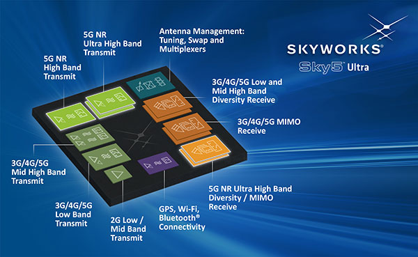
Skyworks Solutions Inc. has launched the Sky5 Ultra, an advanced 5G cellular architecture.
The fully integrated, baseband agnostic solution combines all of the critical front-end functionality required to enable high-performance 5G mobile devices with global coverage in a compact form factor.
Graphic: Business Wire
The comprehensive platform features transmit and receive capabilities with high efficiency and output power, enabling reliable network connections while optimizing battery life — both critical for 5G applications.
In addition, the Sky5 Ultra leverages DSBGA packaging to reduce the footprint and advanced TC-SAW and BAW filtering to provide the best performance at each targeted frequency band.
The solution also supports up to 100-MHz wide bandwidth, maximizing data throughput at ultra-fast speeds.
5G rollouts have already begun and will continue to ramp over the next few years. According to the Global Mobile Suppliers Association, 11 worldwide operators have announced limited 5G service launches and seven additional operators have turned on 5G base stations, with commercial services to follow.
“With industry momentum accelerating towards 5G, Skyworks is leading the way with the technological innovations and systems expertise demonstrated by our Sky5 portfolio, a highly flexible and customizable suite designed to meet customers’ global requirements,” said Joel King, senior vice president and general manager of Mobile Solutions at Skyworks.
“Sky5 Ultra represents another breakthrough in simplifying the growing complexity of 5G device development — delivering unmatched performance while expediting deployment through full integration and optimized form factors. We are empowering top mobile device manufacturers and network providers with complete, turnkey solutions that will ultimately bring 5G to realization,” King said.
About Sky5 Ultra
Sky5 Ultra incorporates Skyworks’ high-efficiency transmit, diversity receive (DRx) and MIMO modules with industry-leading noise figure and low insertion loss, in addition to an array of aperture tuners and antenna swap switches for optimal antenna management.
Like all Sky5 solutions, the comprehensive front-end platform supports new 5G NR waveforms and spectrum in addition to enhanced carrier aggregation and 4G/5G dual connectivity, while delivering exceptional levels of integration and performance. Functional core blocks include:
Primary Transmit (Global)
SKY5-8255 – Dual-chain N77/N79 ultra-high–band power amplifier with integrated low noise amplifier and filters (LPAMiF)
SKY5-8254 – N41 high band power amplifier with integrated filter (PAMiF)
SKY5-8265 – Mid-/high-band power amplifier with integrated low noise amplifier and duplexers (LPAMiD) with DSBGA packaging
SKY5-8211 – Low-band LPAMiD
SKY5-8212 – Low-band LPAMiD with DSBGA packaging
SKY77365 – Global system for mobile communications (GSM) power amplifier
SKY13725 – Low band DRx module with DSBGA packaging
SKY13726 – Mid/High band DRx module with DSBGA packaging
SKY13727 – Mid/High band MIMO module with DSBGA packaging
SKY5-3728 – Ultra high-band N77/79 DRx/MIMO module with SRS support
Antenna Management
SKY5-9269 – SP4T 80v aperture tuning and RF distribution switch
SKY5-9256 – 4 x SPST 45v aperture tuning switch
SKY5-9699 – DPDT antenna swap switch
At Mobile World Congress, Skyworks representatives are in the Executive Meeting Area in Hall 2, 2G3Ex and 2G5Ex.
Image: iStock.com/metamorworks via Bentley Systems
Nestwave has developed an ultra-low power, advanced GNSS solution for use in internet of things (IoT) applications.
Nestwave, a Paris-based startup, is demonstrating its new low-power, high-accuracy GPS IP at Mobile World Congress, being held Feb. 25-28 in Barcelona, Spain.
The software-based GNSS solution allows modem customers to add accurate position-based services to their modem platforms.
When integrated with an IoT modem such as NB-IoT, Cat M1, LoRa or Sigfox, the solution offers low-cost geolocation for emerging applications such as asset tracking, smart factories and smart cities, without the need for an external GNSS chip.
“After several years of development and based on a number of key signal processing breakthroughs, we believe Nestwave is well-positioned to provide a best-in-class solution for low-power IoT applications where position awareness is key,” said Rabih Chrabieh, Nestwave CEO. “We are excited to demonstrate our GPS solution, in collaboration with Cadence by leveraging their Tensilica Fusion F1 DSP platform at MWC this year.”
“The Fusion F1 DSP is gaining traction with customers as a platform for low-cost, power-sensitive IoT communications standards like NB-IoT,” said Gerard Andrews, director of marketing for Tensilica products at Cadence.
The Cadence Tensilica Fusion F1 DSP is designed for low-cost IoT applications requiring a single processor core that is proficient at both DSP and control-code workloads.
Developed on a highly configurable architecture, the Fusion F1 DSP is specifically designed to excel at “always-on” processing, including wake-on-voice and sensor fusion applications.
Additionally, the Fusion F1 DSP instruction-set architecture is very efficient at running narrowband wireless communications standards like BLE, Thread, Zigbee, 802.11ah, NB-IoT and GNSS.
Visit the Nestwave/Cadence demo at the Cadence booth at Fira Gran Via, hall 6, stand 6L34.
OriginGPS, maker of small-format GNSS modules and cellular internet of things (IoT) systems, presented new products with customized IoT and GPS demonstrations at Embedded World 2019, Nuremberg, Germany, Feb. 26-28, Hall 3, Booth 3-121.
OriginIoT systems enable developers to rapidly develop IoT products with stackable add-ons, while all data is configured from the cloud, and no additional embedded code or RF knowledge is required.
OriginGPS’ latest release is the multi-constellation ORG1518-MK06 module. It combines low power modes for extended battery life, 8MB built-in Flash memory, AGPS support for extended ephemeris improving position calculation, and UART+I2C or UART+SPI interfaces.
Selectable add-on sensor boards click on the OriginIoT cellular IoT system, offering backward compatibility with 2G, 3G, CAT1 and CAT M. (Image: OriginGPS)
An ultra-sensitive integrated patch antenna easily switches over to an external antenna via an integrated RF switch.
The ORG1518-MK06 is suitable for solutions requiring multiple antenna options, such as automotive aftermarket and agriculture applications.
Addressing the global IoT market with fast data transmission, the OriginIoT NB-IoT/CAT M with 2G fallback will be suited to devices that are battery-powered and transmit data only occasionally, such as parking and agriculture applications, resulting in a very long sensor battery life, typically 10+ years. The new model will be released later this year.
“The new products are based on OriginGPS patented technologies and retain the miniature footprint for which the company has become synonymous,” said Robert van Tilburg, vice president, Global Sales and Business Development, OriginGPS. “We are excited to offer our customers additional features and options to choose from, enabling them to reduce overall solution costs. 2019 is going to be an exciting year with technology advancements facilitating our product offering with more personalized IoT and GNSS products.”
OriginGPS partner Gemalto will also be presenting OriginIoT demos at Hall 3, Booth 3-438. Gemalto’s Cinterion LTE-M module is integrated in the OriginIoT systems to provide 2G, 3G, Cat1, Cat-M and NB-IoT cellular communication.
Testing the antenna performance of GNSS signals such as GPS, GLONASS, Beidou, Galileo and Metropolitan Beacon Systems (MBS) is key to location accuracy performance of a mobile device.
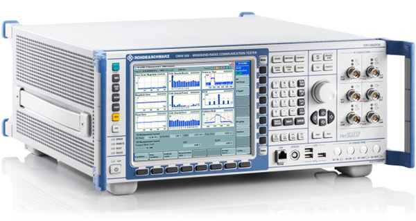
To address the testing need for A-GNSS services, Rohde & Schwarz and Bluetest are partnering in creating test concepts for over-the-air (OTA) antenna measurements.
The CMW500 wideband radio communication tester. (Photo: Rohde & Schwarz)
The two companies integrate the R&S LBS Server, a software component running on the R&S CMW500 wideband radio communication tester, and the Bluetest OTA test solution for A-GNSS systems based on Bluetest’s RTS65 reverberation chamber and Bluetest’s Flow measurement software.
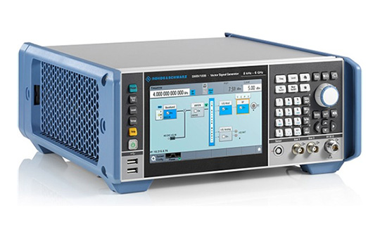
In the test setup, the R&S LBS Server controls the Rohde & Schwarz base-station simulator R&S CMW500 for LTE, WCDMA and GSM, and uses the R&S SMBV100B vector signal generator for simulation of GNSS and MBS signals.
A simple and straightforward upgrade of the setup for 5G will be available soon, making sure that investments are protected and most relevant standards can be tested with the same system.
The R&S LBS Server is an essential part of the R&S TS8991 OTA Performance Test System. This cooperation between Rohde & Schwarz and Bluetest marks the first time that the R&S LBS Server, used here as a software tool on R&S CMW500, is available also for third parties.
“We are delighted to collaborate with Bluetest to contribute with our test and measurement expertise to OTA 4G/3G/GSM and GNSS technology development,” said Alexander Pabst, vice president, Systems and Projects at Rohde & Schwarz. “With a strong global footprint for location based services LBS and close cooperation with partners, Rohde & Schwarz is committed to accompanying the evolution path from OTA testing for GPS, GLONASS, BeiDou and Galileo with innovative test and measurement solutions.”
“The addition of A-GNSS measurements means that the full range of wireless technology in a modern cellular device can be verified with just one test solution,” said Robert Rehammar, Bluetest CTO. “Bluetest has enjoyed the close cooperation with Rohde & Schwarz on this project, leading to a very strong joint solution and customer offering.”
CEVA Inc. and Nurlink have introduced Nurlink’s NK6010 3GPP Rel.14 eNB-IoT system-on-chip (SoC), powered by the CEVA-Dragonfly NB2 IP solution.
The companies made the announcement in advance of Mobile World Congress, which takes place Feb. 25-28 in Barcelona, Spain.
According to the companies, NK6010 is a cost- and power-efficient NB-IoT system on chip (SoC) designed specifically to enable narrowband connectivity in massive internet of things (IoT) devices such as smart meters, wearables, asset trackers and industrial sensors.
The SoC, built around the CEVA-Dragonfly NB2 solution, incorporates an RF front-end, RF transceiver, cellular baseband, power management unit and application processor, all highly integrated to minimize the size and cost of the device.
The SoC includes an extremely low-power multi-GNSS subsystem, supporting GPS/Beidou/Galileo/GLONASS global navigation systems, to ensure highly-accurate device tracking and locating, worldwide, the companies said.
It also supports all NB-IoT frequency bands and major global carriers, ensuring smooth and rapid certification of devices on any NB-IoT commercial network around the world.
The CEVA-Dragonfly NB2 IP solution is a modular technology, composed of the CEVA-X1 IoT processor, an optimized RF transceiver, baseband, and a protocol stack to offer a complete Release 14 Cat-NB2 modem IP solution that significantly reduces time-to-market and lowers entry barriers.
It is a fully software-configurable solution and can be extended with multi-constellation GNSS and sensor fusion functionality. The IP includes a reference silicon of the complete modem design, including an embedded CMOS RF transceiver and PA, an advanced digital front-end, physical layer firmware and a protocol stack (MAC, RLC, PDCP, RRC, and NAS).
“We developed NK6010 to meet the exceptional demand for NB-IoT chipsets to power the multitude of new use cases and applications that narrowband cellular connectivity serves,” said Xiaohua Kong, Nurlink CEO. “The CEVA-Dragonfly NB2 enabled us to massively accelerate our time-to-market by providing many of the key building blocks for our SoC design, already silicon proven and pre-integrated.
“In addition, through the programmable nature of the Dragonfly solution, our engineering team were able to add our innovation during the communication system development and SoC customization,” Kong said. “This framework eventually helped us to create a truly differentiated product. Our path from licensing to silicon was achieved in under one year, and we’re now engaged with operators worldwide to certify our SoC.”
“NB-IoT has reached critical mass, with more than 60 operators around the world already supporting the standard and dozens more launching coverage imminently,” said Michael Boukaya, vice president and general manager of the wireless business unit at CEVA. “Now the drive towards ultra-low cost NB-IoT chipsets and modules has begun and Nurlink, powered by our CEVA-Dragonfly NB2 IP solution, is one of the early entrants into this fast growing space. We applaud their efforts to reach the market so quickly and look forward to monitoring their success.”