AUVSI Xponential 2019 — the huge exhibition and conference built around unmanned everything — will run at the West Building, McCormick Place Convention Center, April 29 to May 2 in Chicago.
This is the premier show for the Association for Unmanned Vehicle Systems International (AUVSI) group and its many members and supporters who have interest in unmanned technology — 8,500 attendees with connection to unmanned and autonomous capability are expected to walk the exhibit hall to see the latest products, hear numerous related presentations, participate in educational courses, and mingle with other like-minded people in the industry.
I was looking for a way to provide a brief overview of the companies exhibiting; a sample cross-section to provide an insight on what to expect. But with more than 700 exhibitors, it’s a difficult thing to do. Then I realized that the company show preview emails in my inbox were from organizations that were actually quite representative of the industry, and I had my overview selection.
Flyability’s drones are adapted for inspection tasks, both indoors and out, with an exterior protective cage. Routine inspection jobs indoors, underground and around complex pipework become quicker, safer and are fully documented by high-resolution video and stills.
This all enables the reduction of costs and process-interruption downtime of industrial inspections, while also reducing to a large degree the risks for inspection professionals. Industries using these inspection drones include power generation, oil and gas, chemicals, maritime, infrastructures and utilities, and public safety.
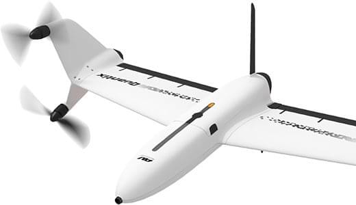
AeroVironment’s drones are used extensively by the military for surveillance and reconnaissance, and in the commercial sector they focus on tools for agriculture.
Quantix drone. (Photo: AeroVironment)
The VTOL (vertical take-off and landing) Quantix drone system is fully automated for takeoff, flight and landing, enabling mapping of farm acreage to monitor crop health to identify anomalies due to water, insect, weed and disease so their impact on yield can be minimized.
Valqari has developed a drone mailbox that is interoperable with a large number of delivery drones and enables drop-off of packages in residential neighborhoods.
The Valqari drone mailbox automatically accepts packages and safely stores them until the recipient opens the box later to retrieve them.
Cepton Technologies makes lidar systems more commonly used for automotive obstacle detection, but now customized for UAV integration and use. Its UAV lidar system provides long-range, high-resolution and low-cost mapping capabilities in a lightweight package. With a scanning range of 200 meters, high-density map-data acquisition becomes possible.
Deseret UAS is a non-profit working to bring UAS business to Utah — the organization offers information, promotes UAS companies and offers test-range access in Utah. In collaboration with Utah State University AggieAir, FAA authority for flight testing in wide open; low-risk operational areas of Utah can be accessed.
And, of course, General Atomics Aeronautical Systems (GA-ASI), manufacturer of the well-known Predator military drone, will exhibit. At Xponential 2018, GA-ASI unveiled its MQ-9B SkyGuardian certifiable drone system. Through the year, the company has progressed towards certification of the system for flight within the U.S. civilian National Airspace System and the civil airspace of other countries around the world.
GA-ASI’s latest media release recounted how an MQ-9B was flown by the company’s Certifiable Ground Control Station (CGCS) on March 9, including both take-off and landing. The CGCS architecture separates flight and mission-critical functions. Off-the-shelf avionics and flight computers are used for flight-critical functions, and mission-critical functions run alongside GA-ASI’s Advanced Cockpit payload and weapons equipment.
Meanwhile, High Altitude Pseudo-Satellite (HAPS) unmanned aircraft are back in the news with what appears to be a crash during the sensitive take-off/climb-out regime. The Airbus Zephyr aircraft — with an 82-foot wingspan, but weighing less than 75 pounds — was engaged in a test campaign in Western Australia when the ground abruptly intervened on March 15.
Airbus is working with the UK Ministry of Defence to demonstrate the operational capabilities of the UAV and its anticipated payload options. Once airborne, Zephyr is intended to climb out to upwards of 65,000 feet into the stratosphere — previously achieving a maximum altitude of 74,000 feet — and has so far been able to remain airborne for almost 26 days. The object is to create a commercial, reusable, reconfigurable satellite-like capability for communications and surveillance applications.
Airbus and MoD are undertaking a crash investigation to determine what exactly happened and how to prevent future recurrence. The incident occurred about four hours into a demonstration flight, and (reading between the lines) may have been related to rapid weather changes that destabilized the UAV while in the take-off and climb-out phase. An automated launch system is in the works — currently Zephyr is man-handled for take-off.
Other HAPS programs include AeroVironment and Japan’s Softbank, Astigan and the UK Ordnance Survey, BAE Systems and Prismatic, and Boeing’s Aurora Flight Sciences. Thales, meanwhile, is apparently focusing on an approach using an autonomous airship.
So some good news, some not so good. Lots of attendees are expected in Chicago for the AUVSI Xponential show, with new developments in unmanned aircraft, robotics, and unmanned ground and water systems anticipated in the exhibition hall. There will be lots of people in the industry with whom to exchange ideas and conduct business to conduct, hopefully just as spring arrives in the windy city.
Meanwhile, over the coming months Airbus will no doubt continue to work out how to overcome the latest problems in HAPS technology and operations.
Belgium has launched its first smart highway test environment. Septentrio GPS/GNSS receivers are integrated into vehicles and infrastructure to provide dependable, high-accuracy positioning and to aid sensor fusion in driverless navigation and truck platooning.
Septentrio’s high-precision GPS/GNSS technology will be one of the key components in a Smart Highway system, which launched April 8 with a live demonstration in Antwerp, Belgium. A section of a highway will be dedicated as a test environment for technology which prepares Belgium for automated driving and truck platooning.
When vehicles are aware of each other’s position and velocity, road efficiency and safety can be significantly improved by smoothing traffic flow and automatically breaking if slowing traffic is detected ahead.
Roadside units along the highway will feature GNSS receivers acting as reference stations, sending out continuous positioning corrections. Onboard GNSS units will use these corrections together with built-in quality indicators to calculate trustworthy, sub-decimeter positioning. They will also provide precise timing for syncing the multitude of sensors onboard these “smart vehicles.”
“We are excited to be a part of the Smart Highway testbed which is aimed at improving road safety and traffic flow,” said Jan Van Hees, business development director at Septentrio. “The automotive ecosystem is undergoing a shift towards automation enabled by the latest technology in communications, sensors and precise positioning. Our role in this project builds upon our strategy to continue providing high-accuracy, reliable positioning solutions aimed at the automotive industry.”
The Advanced Interference Mitigation (AIM+) technology shields Septentrio receivers from interference. On a highway, an increasing number of trucks are equipped with illegal jamming devices to avoid road tolling. These jamming devices can interfere with GPS signals used by other vehicles and infrastructure.
Smart Highway is a project of the Flemish government coordinated by imec, a world-renowned research and innovation hub of nano-electronics and digital technology. Septentrio, Toyota, Ericsson and Telenet are contributing industry partners for the project, while UAntwerpen, UGent and others are research partners.
On the European level, the CONCORDA project supports research and development of automated vehicle technology and infrastructure in Germany, Spain, France, Netherlands and Belgium.
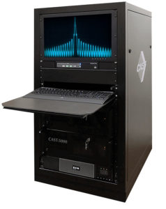
The CAST-5000 produces a single coherent wavefront of GPS RF signals to provide repeatable testing in the laboratory environment or anechoic chamber. The basic system generates four independent, coherent simulations that reference a single point and is upgradeable to support seven elements for CRPA testing. With an intercard carrier- phase error of less than 1 millimeter, the CAST-5000 is extremely accurate.
The system generates a wavefront of GPS when its GPS RF generator cards are operated in a ganged configuration. Each generator card provides a set of GPS satellites coherent with the overall configuration. Several RF generator cards may be utilized together, ensuring phase coherence among the bank of signal generator cards.
The CAST-5000 Controlled Reception Pattern Antenna (CRPA) tester allows a full end-to-end test of the antenna system. The CRPA antenna, antenna electronics and the GPS receiver can be tested as a unit with or without radiating signals.
The CAST-8000 is a new simulator that merges both the CAST-5000 CRPA tester with a CAST-3000 EGI tester.
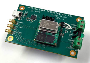
The tiny 1-inch square Micro-Transcoder module allows glueless retrofitting of existing GPS equipment with secure and Assured-PNT (A-PNT) capability. It is the smallest, full-constellation, stand-alone, real-time 10-channel GPS simulator available from JLT. The unit is useful in upgrading existing legacy GPS receivers with external position, navigation and timing references such as INS, CSAC, SAASM, M-code, GNSS, eLoran or other alternative positioning and timing sources by simply replacing the legacy GPS antenna from an existing GPS system with the Micro-Transcoder RF output.
The unit is based on the JLT CLAW GPS Simulator and RSR Transcoder technologies, and includes a general-purpose, stand-alone, full-constellation, 10-channel, real-time GPS simulator with integrated high-stability timing reference, as well as an internal GNSS receiver for monitoring the RF output signal for quality and accuracy. The unit will transmit a standard UTC time, position, velocity and heading GPS L1 C/A RF signal by simply applying 3.3V power to it.
The Micro-Transcoder can also be operated as a generic GPS simulator with built-in GPS Disciplined Oscillator (GPSDO), and is supported by a free Windows application downloadable from the JLT website. The Windows application allows control of all the simulation aspects, creating and storing simulation vector commands and testing user equipment for leap-second and GPS week rollover event compatibility to identify weaknesses in user equipment. The unit does not require a connected PC to function. The Micro-Transcoder is also available mounted onto an evaluation board for easy evaluation. The unit transcodes baseband PNT NMEA signals into a GPS L1 RF signal with typically less than 100-ms latency. UTC 1PPS timing-transfer accuracy to the GPS RF output is typically better than 5 ns. The unit requires only 3.3V to operate, and setup, location and simulation vector file information can optionally be stored in its internal NV memory.
For those responsible for mission-critical PNT applications, the Orolia GSG series of GPS/GNSS simulators is an important tool to evaluate risk for jamming, spoofing or any other threat. Orolia GSG-5/6 series simulators are easy to use, feature-rich and affordable, offering a way to harden GPS-based systems without the limitations of testing from “live sky” signals. The Orolia platform approach allows customers to buy only what they need today and upgrade later. The adaptability of the GNSS RF generation platform can extend to applications for intelligent repeating.
Test Solutions
Position accuracy and dynamic range/sensitivity
Simulate movements/trajectories anywhere on or above Earth
Sensitivity to GPS impairments: loss of satellites, multipath, atmospheric conditions, interference, jamming and spoofing
Conducted or over-the-air RF
GPS time-transfer accuracy
Effect of leap-second transition
Multi-constellation testing
Modernization signals/frequencies
Keyless military SAASM, dual-frequency and survey-grade receiver testing
Infrastructure possibilities include zone-based indoor location (intelligent repeating) and pseudolite applications.
GSG-6 Series 64-channel multi-frequency, advanced GNSS simulator is powerful enough for any cutting-edge test program. GPS, GLONASS, Galileo, Beidou, QZSS and NAVIC (IRNSS) signals are available across multiple frequencies. The GSG-6 is designed for military, research and professional applications.
GSG-5 Series 16-channel multi-constellation L1-band GNSS simulator is designed for commercial development/integration programs. It is for developing commercial products with GNSS capability, and will shorten test programs with confidence.
GSG-51 single-channel signal generator is designed for one purpose — fast, simple go/no-go manufacturing test and validation, ensuring the manufacturing line is operating at full capacity with confidence in quality.
Specifically designed for testing GNSS interferences and cyber-attacks. QA707 has been designed to test robustness against emerging cyber-threats beyond jamming and spoofing. It allows the creation of scenarios with signal and code jamming, data-level cyber-attacks, denial of service threats, low-level spoofing channels control, and trajectory-controlled spoofing.
Optimal for signal modernization design. Being a flexible software defined radio (SDR) solution, QA707 is also suitable for testing of signal modernization and for the simulation of new signal components. An open API is provided to create specific signals simulation. Particularly, the tool is ready to support the upcoming Galileo Open Service Authentication (OSNMA).
Runs on a standard PC or laptop with USRP or other hardware. QA707 is compatible with several third-party hardware RF up-converters, including National Instruments’ USRP. It also can support customer’s specific hardware through the hardware API interface. Qascom introduces the new frontier of GNSS security testing. QA707 is supported from back office with custom services as well as jamming and spoofing mitigation solutions for receivers and applications. This covers 100% of customer GNSS security needs.
QA707 Main Features
Multi-constellation (GPS L1, Galileo E1, SBAS L1)
Galileo OSNMA ready
RF simulation, binary file dump, signal record and replay
Support to SDR platforms and open API for custom RF upconverters
The LabSat 3 Wideband is easy to use, cost-effective and produces extremely low noise, accurate and repeatable signals. Users can record and replay up to three different channels at 56 MHz with a bit depth of up to 3 bits I and 3 bits Q.
The following signals can be recorded and replayed:
2X CAN, RS232, and digital inputs recorded and replayed tightly synchronized with GNSS data
Small, battery or mains powered and with a removable SSD (up to 4 Tb), LabSat 3 Wideband allows detailed, real-world satellite data to be recorded then replayed on the bench. The rugged enclosure measures a compact 167 x 128 x 46 millimeters and weighs 1.2 kilograms, meaning it can be placed in a backpack and used to reliably record real-world signals in almost any situation.
SatGen Signal Simulation Software
If a user wants to simulate the signals from scratch, Racelogic’s latest SatGen signal simulation software can produce synthesized scenarios containing the full complement of popular GNSS signals: GPS L1, L2C, L5, GLONASS L1, L2, Galileo E1, E5, E6 and BeiDou B1, B2.
SatGen software allows users to quickly create accurate scenarios with their own time, place and trajectory, with any combination of constellation and signal that is currently available or will become available in the near future.
Precision-sensitive applications such as autonomous driving, control of unmanned aerial vehicles (UAV), or positioning of aircrafts during landing procedures in coordination with ground-based augmentation systems (GBAS) require that modern GNSS receivers undergo detailed tests before implementation.
Designed to generate highly realistic test scenarios, Rohde & Schwarz signal generators like the R&S SMW200A and the R&S SMBV100B offer a unique approach to generating complex and highly realistic scenarios for testing of GNSS receivers that are able to work with diverse navigational systems such as GPS, GLONASS, Galileo, BeiDou and QZSS/SBAS signals. The R&S SMW200A and the R&S SMBV100B can emulate them all for testing.
R&S SMW200A
The R&S SMW200A GNSS simulator (pictured above) can be used to produce complex interference scenarios with multiple interferers — all generated within the instrument itself. It can emulate up to 144 GNSS channels and can be equipped with up to four RF outputs. With its ability to simulate multi-constellation, multi-frequency, multi-antenna and multi-vehicle scenarios, the R&S SMW200A is able to cover a variety of high-end GNSS applications.
R&S SMBV100B
The R&S SMBV100B supports the same navigational systems, with access to 24 GNSS channels and one RF output, with the same ability to configure realistic scenarios including obscuration, multipath and atmospheric effects, as well as the specific characteristics of the antenna and the simulated vehicle. An integrated noise and CW interference generator can also be added.
Since the devices do not require an external PC for scenario configuration, all the tests can be created quickly through the user-friendly GUI. Due to all-encompassing instrument options available, both simulators can be set up to fit unique user requirements.
For testing GNSS receivers under controlled and repeatable conditions, the R&S SMW200A and the R&S SMBV100B provide extensive and cost-effective solutions. The platforms are ready to adapt to future requirements and testing of newly implemented GNSS signals.
SDX is a proven and advanced GNSS simulator based on GPU-accelerated computing and software-defined radio (SDR).
It is available as a complete turnkey system suitable for all GNSS simulation needs, including everything from compact test benches to complete CRPA test systems, such as SDX wavefront and SDX anechoic. Moreover, its software-defined roots enable the selection of cost-effective hardware into configurations that can be repurposed for different projects.
The architecture behind SDX provides real-time simulation of uncompromising accuracy. It features advanced signal customization and supports configurable outputs. IQ data can be generated in, or imported back into, the simulator as well. The API is embedded in the simulator core, enabling deep automation with a few simple clicks, as well as complex scripts developed with popular programming languages.
SDX simulates multiple constellations on multiple frequencies (GPS, Galileo, GLONASS, BeiDou and SBAS) on a large number of channels. Encrypted codes are supported for GPS and Galileo.
The Advanced Jammer module in SDX gives users complete control over interference creation. It is integrated directly into simulation scenarios to enable dynamic jammers (up to 120dB J/S) to interact with GNSS signals.
SDX also allows users to create advanced scenarios suitable for any type of vehicle: antenna patterns (receiver and GNSS SV), LEO/GEO/HEO orbits, multipath, hardware-in-the-loop (HIL), additive pseudorange errors, message modification and corruption, raw logging and more.
It is suitable for the design and validation of GNSS receivers, complex integration, academic research, NAVWAR and test engineering.
SDX is developed and actively supported by Skydel’s engineering teams and worldwide distributors. Skydel offers direct support to clients to ensure prompt deployment and integration, or to review advanced customization requirements.
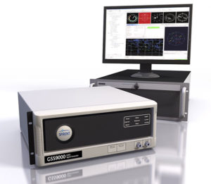
GSS9000, SIMMNSA, CRPA Test System, anechoic chamber testing, mid-range testing
Photo: Spirent
Spirent Federal provides GPS/GNSS test equipment that covers all applications, including research and development, integration/verification, and production testing.
GSS9000. The Spirent GSS9000 Multi-Frequency, Multi-GNSS RF Constellation Simulator is Spirent’s most comprehensive simulation solution. It can simulate signals from all GNSS and regional navigation systems and has a system iteration rate (SIR) of 1000 Hz (1 ms), enabling higher dynamic simulations with more accuracy and fidelity. The GSS9000 supports restricted/classified signals. Users can evaluate the resilience of navigation systems to interference and spoofing attacks, and have the flexibility to reconfigure constellations, channels, and frequencies between test runs or test cases.
SimMNSA. SimMNSA allows authorized users to simulate true M-code for the first time ever. SimMNSA has been successfully delivered to users of the GSS9000 series simulator. SimMNSA has been granted Security Approval by the Global Positioning System Directorate.
CRPA Test System. Spirent’s Controlled Reception Pattern Antenna (CRPA) Test System generates both GNSS and interference signals. Users can control multiple antenna elements. Null-steering and space/time adaptive CRPA testing are both supported by this comprehensive approach.
Anechoic Chamber Testing. Spirent’s GSS9790 Multi-Output, Multi-GNSS RF Constellation Wave-Front Simulator System is a development of the GSS9000. The GSS9790 is a unique solution providing the core element for GNSS applications that require a test system that can be used in both conducted (lab) and radiated (chamber) conditions.
Mid-Range Solutions. Spirent also offers solutions that cater to intermediate GPS/GNSS testing needs. The GSS7000 multi-constellation simulator provides an easy-to-use solution for GNSS testing that can grow with users’ requirements. The GSS6450 RF record & playback system enables replay of a real-world GNSS/GPS test repeatedly in the lab.
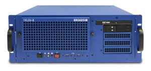
A scalable software-defined simulation platform powered by Skydel’s SDX, capable of generating high-fidelity GNSS and jamming signals simultaneously across multiple constellations and vehicles. Simultaneously simulate every signal below:
BroadSim’s software-defined platform includes intuitive user control and APIs; fast development cycles; flexible licensing and upgradability; and no additional hardware needed to maintain.
Forms
Original (4U)
Rack-mounted 4U simulator used for lab or field testing
4 RF outputs (unlimited jamming signals generated on 1)
1000-Hz simulation iteration rate
High-performance processor, GPUs and memory
Anechoic
Simulation system used for anechoic chamber testing
32 RF outputs and 16 dual-frequency antennas
Automatic antenna mapping
Automatic time delay and power loss calibration
Wavefront
Phase coherent simulation system
Real-time automated phase calibration
Scalable from 4 to 16 elements
Supports CRPA and multi-element receiver testing
Supports jamming and spoofing
Panacea
An automated PNT performance and vulnerability test suite that supports up to 32 UUTs (units under test) in real time, from test plan creation to post-test evaluation.
Time synchronization to live sky
Compatible with 100+ different GNSS receiver brands
Create dynamic scenarios with parameters such as jamming patterns, motions, power loss, delays and more.
Manages receiver communication and standardizes data output for easy analysis, visualization and reporting
Spirent Federal Systems, a provider of GPS/GNSS test equipment, announced that Col. (retired) Bernard Gruber, former program director of what is now the U.S. Air Force GPS Directorate, has joined the company’s board of directors as government security committee chairman. Also joining as the chairman of the board is Robert Lollini.
Spirent Federal President/CEO Ellen Hall stated, “We are happy to have retired Col. Gruber and Bob Lollini joining our dynamic company. We are leading the industry in innovation and quality products for the U.S. government and these two new leaders will help us continue that momentum.”
Col. Bernie Gruber in 2012. (Photo: U.S. Air Force)
Bernard Gruber brings to the position the experience gained from a long and distinguished career in the government and military sector. Mr. Gruber has held several positions in important commands focused on navigation in space, including serving as the chief of Space and Global Integrated Intelligence at the Pentagon from 2009-2010, and director of the Global Positioning System (GPS) at the Los Angeles Air Force Base from 2010-2013. He is currently the director of Precision Guidance and Advanced Programs, Armament Systems at Northrop Grumman.
Robert Lollini is currently the chief executive officer and president of BioFire Defense LLC, a subsidiary and proxy company of bioMerieux. Lollini contributes to the board his broad understanding of strategic financial and executive management.
Spirent Federal Systems was formed in July 2001 by Spirent Communications as a wholly owned subsidiary and U.S. proxy company. Spirent Federal markets and sells Spirent Communications’ GNSS products in North America. The company also provides value-added features and ongoing customer support. Spirent Federal Systems is headquartered in Pleasant Grove, Utah, with support and sales offices throughout the U.S.
The GEO-FOG 3D Dual inertial navigation system (INS) is designed for applications that require heading at system startup or in low dynamic conditions. (Image: KVH)
KVH Industries will showcase its inertial products at Ocean Business 2019, taking place in Southampton, U.K., April 9-11.
When GNSS is not an option, KVH’s Fiber Optic Gyro (FOG)-based IMUs and inertial navigation systems — the GEO-FOG 3D and 3D Dual — provide accurate and reliable navigation for manned and unmanned maritime and underwater systems, the company said.
“When we compare the data and performance of the KVH 1750 IMU to comparable SWAPC components, we find a tremendous disparity in performance,” said Ben Kinnaman, CEO of Greensea Systems Inc. “The KVH 1750 IMU outperforms similar components and sensors in that category by orders of magnitude.”
Visit KVH at Stand J8 and learn more about KVH’s FOG-based 1750 IMU, which is available with 2g accelerometers and designed specifically for subsea vehicle navigation and positioning.
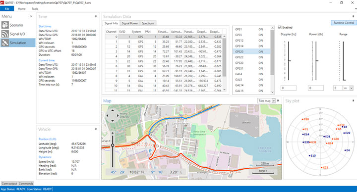
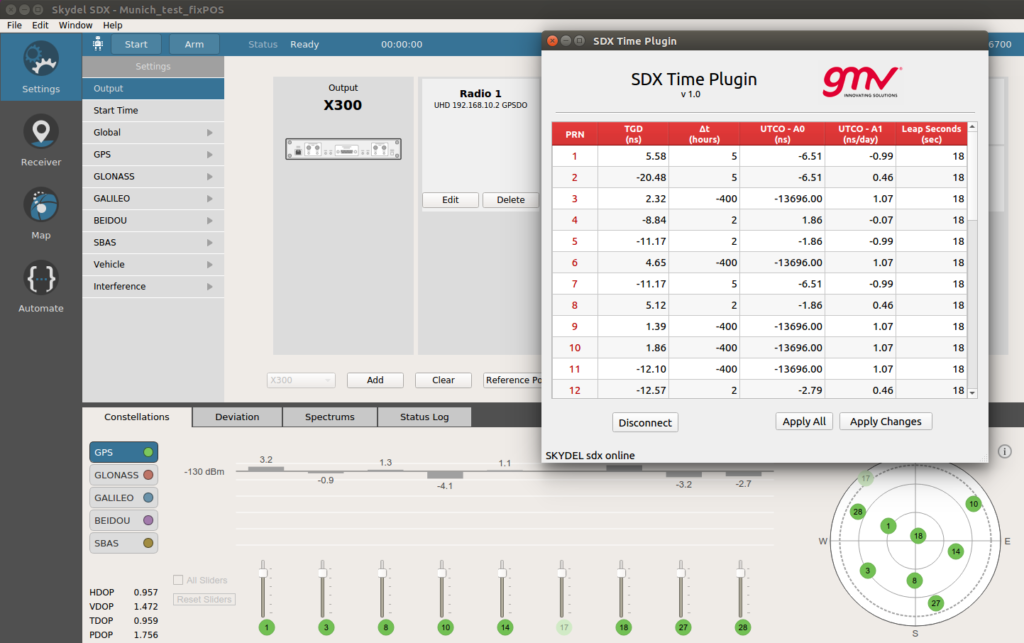
With Orolia’s Skydel SDX API, GMV has developed a “Time Plugin” that allows to batch edit the numerical values associated to TGDs, UTCO and Leap Seconds. (Image: GMV)
GMV uses the flexibility of Skydel SDX to simulate GNSS timing events.
The upcoming GPS Week Number Rollover (WNRO) on April 6 is a known feature of GPS that occurs only every roughly 20 years and thus can be anticipated and tested in a receiver using a GNSS simulator.
A less-known rollover effect is also present in the Week Number (WN) associated to the UTC Offset (UTCO) transmitted by GPS. This WN has only 8 bits, which implies a range of values from 0-255, equivalent to a rollover every roughly 5 years. A possible failure in the receiver interpretation of the UTCO WN would not have such dramatic effects as a general GPS WNRO, but it could seriously affect the output of a GPS timing receiver.
Other than WN rollovers, un-programmed GNSS timing glitches are extremely rare but not impossible. A well known case is the GPS anomaly of Jan. 25-26, 2016, when around half of the satellites in the constellation transmitted an incorrect UTCO value during 12 hours. The transmitted value was of the order of 13 microseconds, when the correct value is usually of the order of just a few nanoseconds. This caused many timing receivers around the world to provide an incorrect timing information or to fail altogether.
Other fields in the GPS navigation message that could potentially be corrupt and cause incorrect timing output are Timing Group Delays (TGDs), and Leap Second information. In general, any event related to the contents of the GPS navigation message can be simulated by editing the associated bits in the message, for each satellite PRN.
However this is a cumbersome and prone-to-error task. Orolia’s Skydel SDX simulator provides an Application Programming Interface (API) that allows to develop SDX extensions to tackle particular simulation problems in an easy and flexible way.
By using this API, GMV has developed a “Time Plugin” that allows to edit directly on a user interface the numerical values associated to TGDs, UTCO, and Leap Seconds, per individual satellite PRN. These values are then converted to bits in the GPS message and transmitted in the RF stream to feed the receiver under test. Events like, for example, the GPS anomaly of Jan. 25-26, 2016, can be easily tested (as shown in the screenshot).
Inertial 2019, the sixth annual Institute of Electrical and Electronics Engineers (IEEE) International Symposium on Inertial Sensors and Systems, took place in Florida earlier this month. Events of particular note included two keynote talks from experts at the U.S. Defense Advanced Research Projects Agency (DARPA) and the Air Force Institute of Technology (AFIT), and a technical paper on the “Design and Performance of Wheel-mounted MEMS Inertial Measurement Unit (IMU) for Vehicular Navigation.”
Miniature Sensors. Ronald Polcawich from DARPA addressed “Miniature Navigation Grade Inertial Sensors: Status and Outlook.” The agency’s Precise Robust Inertial Guidance for Munitions (PRIGM) program has focused for more than three years on developing inertial sensor technologies to enable PNT in GPS-denied environments. PRIGM has developed a navigation-grade inertial measurement unit (NGIMU) based on micro-electromechanical systems (MEMS) platforms. The device has a mechanical/electronic interface compatible with drop-in replacement for existing tactical-grade IMUs on legacy U.S. Department of Defense (DoD) platforms.
PRIGM’s second main area of interest is advanced inertial micro sensor (AIMS) technologies for future gun-hard, high-bandwidth, high-dynamic-range, GPS-free navigation. It explores alternative technologies and modalities for inertial sensing, including photonic and MEMS-photonic integration, as well as novel architectures and materials systems.
Map-Matching. Aaron Canciani from AFIT educated the many computer scientists, software developers, information technology professionals, physicists and electrical and electronics engineering attendees on “The Importance of INS Accuracy for Map-Matching Navigation.”
The GPS-alternative technique matches measurements from a sensor to a map to provide navigation information. With repeatable measurements, almost any map may be used to navigate. Common maps used for navigation include terrain height, gravity, magnetic fields, Wi-Fi RSS and more. The inertial navigation system often plays a critical role in the accuracy of these methods, and increased INS accuracy plays a synergistic role in an overall map-matching navigation system.
WHEEL-MOUNTED IMUS
In today’s automobiles, MEMS gyroscopes and accelerometers provide essential measurements for enhancing stability and control. Both types of sensors have significant noise at low frequencies, limiting the measurement accuracy, particularly in low-dynamic conditions. Further, uncompensated accelerometer tilt causes large bias to acceleration estimates. For gyroscopes, physical rotation of the sensor can remove the constant part of the gyro errors and reduce low-frequency noise. In ground vehicles, such rotation occurs conveniently in wheels.
When inertial sensors are attached to the wheel, both types of sensors provide information on the rotation, gyroscopes naturally and accelerometers via specific force measurement. As a result of carouseling, accurate wheel heading, roll and pitch estimation can be estimated with high resolution, and the result is nearly bias-free. Combining the wheel orientation to distance traveled via known radius enables classic dead-reckoning mechanization (assuming zero slip) and other vehicle dynamics monitoring systems (considering wheel slip as unknown to be solved).
Authors Jussi Collin of JC Inertial Oy, Finland, and Oleg Mezentsev, Pacific Inertial Systems Inc., Canada, provided details of wheel-mounted inertial system hardware and algorithms and showed test results for several system configurations and applications. They discussed future system improvements — in particular, system miniaturization and an energy-harvesting development progress for next-generation inertial systems.
They have designed a wheel-mountable sensor system that contains MEMS sensors, battery, Bluetooth module and electronics to run computations and navigation algorithms on board. It operates in several programmable modes:
Computes navigation parameters real time and sends them via Bluetooth to an onboard computer (can be any other integrated system, data logger or a tablet).
Sends real-time raw data to an onboard computer.
Records high-rate raw sensor data (up to 2 kHz) to an embedded micro-SD card.
The onboard computer is a MEMS-array IMU with 48 gyro and accelerometer channels, with a BT receiving and sync controller, data storage and Wi-Fi interface. They can connect up to four such units to one onboard computer and have all their data in sync with the in-cabin inertial data. All of this data can be used for navigation, wheel dynamics measurements or road quality monitoring applications.
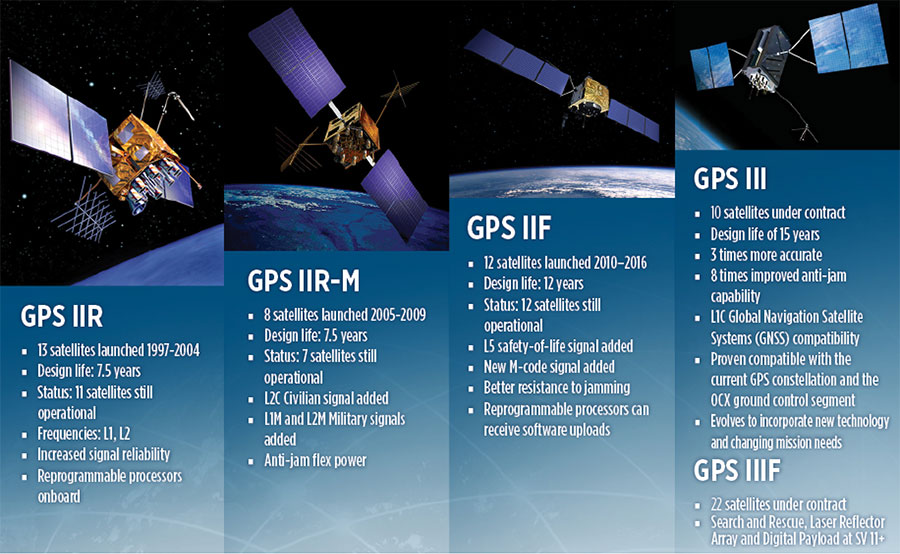
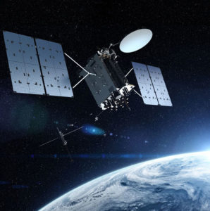
When managed by a new ground control system, GPS III satellites will offer triple the accuracy and eight times the anti-jamming capabilities of the satellites currently comprising the U.S. Air Force’s GPS constellation. Users military and civilian will reap ample benefits.
Everything changed for space-based positioning, navigation and timing around the world on Dec. 23, 2018. Or maybe it didn’t. The innovations heralded by the launch of the first GPS III satellite will take years more to occur. We tabulate here the advances that Generation Three will bring over GPS-to-date, and review the timeline for their actual arrival.
While these new capabilities exist — in concept — in space, they can’t be leveraged on the ground (or in the air, or at sea) until a sufficient number of additional GPS III satellites have joined the constellation, and until a new ground control system comes online. This will occur — perhaps — in 2023. At that time the satellites’ talents will be unleashed.
“As more GPS III satellites join the constellation, it will bring better service at a lower cost to a technology that is now fully woven into the fabric of any modern civilization,” stated Lt. Gen. John Thompson, commander of the U.S. Air Force’s Space and Missile Systems Center and the Air Force’s program executive officer for space.
The many GPS III upgrades should make the service more reliable and accurate for civilians, more secure against those who want to jam military users, and more cyber-secure for everyone.
TALKIN’ ‘BOUT OUR GENERATION
GPS constellations have grown through six major iterations since 1978. The sixth, GPS IIF, rose during the years 2010 to 2016. Those 12 satellites are all designed to last 12 years. Some of their notable features include the ability to receive software uploads, better jamming resistance and increased accuracy.
GPS III, the seventh generation, will launch nine more satellites to join SV01 already in space. GPS III SV02 is scheduled to launch in July of this year, SV03 in late 2019, and SV04 in 2020. The final III payload should rise in 2023. From that point on, the follow-on era of GPS IIIF takes over.
How Long, How Long? “Projections for how long the current constellation will [continue to] be fully capable have increased by nearly two years to June 2021, affording some buffer to offset any additional satellite delays,” reported the Government Accounting Office at the end of 2017. This provided some schedule buffer for launching the first GPS III satellite, but it did not reduce the desire to launch as soon as the booster rocket became available.
The new birds will introduce new capabilities to meet higher demands of both military and civilian users: once filled out, the GPS III constellation will bring three times better accuracy and up to eight times improved anti-jamming capabilities. Spacecraft life requirement will extend to 15 years, 25 percent longer than the latest GPS satellites and twice the original design life of the oldest satellites on orbit today.
The new L1C civil signal broadcast by GPS III is an interoperable signal with other international global navigation satellite systems, like Galileo, improving connectivity for civilian users.
GPS III will eventually actualize full M-code capability — carried aboard the IIR-Ms and IIFs but not yet completely implemented — in support of warfighter operations. GPS III M-code capability exceeds that of GPS IIR-M and GPS IIF.
GPS III will complete the deployment of the L2C civil signal and the L5 safety-of-life signal capabilities that began with \GPS IIR-M and GPS IIF satellites.
Finally, GPS III will enact improved integrity: the ability of the satellite to detect and issue alerts on its own reduced accuracy, should that phenomenon ever occur.
Military Signal Power Up. Encrypted M-code signals will be up to eight times more powerful than currently. This makes them more reliable. but also enables the sats to overcome efforts to jam their signals.
Other signals also offer increased signal power at the Earth’s surface. L1 and L2: −158.5 dBW for aC/A code signal and −161.5 dBW for the P(Y) code signal. L5 will be −154 dBW.
Family Features. The most recent generations of the GPS constellation. IIR, IIR-M and III were produced by Lockheed Martin, while IIF was built by Boeing. One GPS IIA satellite is still in operation, at 25 years young (design life was 7.5 years). All satellites carry Harris Corporation payloads. (Graphic sourced from: Lockheed Martin and Boeing Co.)
L SIGNALS
L2C, the second open GPS signal, after L1 C/A, has been available from every new GPS satellite since the first IIR-M launch in 2005. L5, the third open GPS signal, became available with the first IIF launch in 2010. Now L1C, the fourth open GPS signal, joins the band, broadcasting from every new GPS satellite, starting with the recent GPS III launch (see First Light).
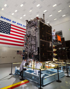
The first GPS III satellite is in checkout and testing that could last up to 18 months before it enters service. “After its Dec. 23 launch, GPS III SV01 successfully completed its orbit raising and deployment of all of its antennas and solar arrays. On Jan. 8, the satellite’s navigation payload began broadcasting navigation signals,” said Johnathon Caldwell, Lockheed Martin vice president for navigation systems. “On-orbit testing continues, but the navigation payload’s capabilities have exceeded expectations and the satellite is operating completely healthy.”
Testing, Testing. Using the Air Force’s Back-to-Basics program, which involved early prototyping and simulations, Lockheed Martin developed GPS III with an approach that involved rigorous quality-build certificates, component testing and system-level testing. The comprehensive requirements verification and validation process ensured more than 30,000 requirements were achieved. The system functional qualification includes the performance verification in multiple environmental tests, including the acoustic, thermal vacuum (TVAC) and electromagnetic spectrum.
“We consider thermal vacuum the gold standard for testing any satellite before it goes into operations,” Col. Steve Whitney, director, GPS Directorate, wrote in GPS World in December. “It really is putting the craft through the paces. When it goes through the testing, the satellite is on. It is working. It is exposing it to the heat and the cold and the zero pressure while the satellite is functional. The entire thermal vac testing from start to end is about 70 days. Test like you fly. From the time it launches and deployment sequence, we test it like it is real. Minus the shaking, the satellite thinks it is getting launched. Meanwhile, our people are looking at the data and its health. TVAC is a huge milestone for a satellite to go through and come out no issues.”
To date, more than 90 percent of parts and materials for all 10 GPS III satellites have been received from more than 250 aerospace companies in 29 states.
BRAIN OF THE BUNCH
THE FIRST GPS III satellite was fully assembled and entered into SV single-line flow when Lockheed Martin technicians integrated its system module, propulsion core and antenna deck. (Photo: Lockheed Martin)
Harris Corporation is a subcontractor to Lockheed Martin for development and production of GPS III Mission Data Units (MDUs) and transmitters for the GPS space section. Six have been delivered.
The Harris MDU, together with the Atomic Frequency Standards and the L-band transmitter equipment, make up the Navigation Payload Element. The MDU performs the primary mission of the GPS satellite: generation of the navigation signals and data on a continuous basis. The MDU controls the generation of the precise timing signals used for navigation signals while distributing the timing signals to other satellite components.
This MDU is 70 percent digital. The next to come, aboard GPS IIIF satellites, will be fully digital.
When asked about the advantages of an all-digital payload, Harris Corporation’s Jason Hendrix, PNT program director, told GPS World in April 2018, “The advantages and the 30 percent difference are the timekeeping system portion. We’re moving from manual, analog timing to digital to deliver to the Air Force more flexibility. It’s a nice option to have to be able to reprogram in orbit and maybe enhance capabilities desired in the future.”
LIVING BETTER, LIVING LONGER
Greater mission longevity is one of the key improvements GPS III delivers over those currently in service. Space Vehicles 1–10 have a planned mission life of 15 years, 25 percent longer than their predecessors. That begs the question, “How long should a satellite live in space, with technology innovation occurring almost annually?”
Advanced payload technology provides a partial answer. Lockheed Martin and Harris point to new payload capabilities with built-in flexibility to adapt satellites in orbit to technology advances, as well as changes in missions. According to Harris, the fully digital navigation payload will provide the ability to change and upgrade the satellites incrementally over mission life.
In late 2017, Lockheed announced a partnership with NEC Corporation to introduce artificial intelligence for computer learning in orbit. The company touted significant advances in processors and a move toward next-generation antennas, arrays and transmitters to drive more satellite flexibility, capability and resilience.
FROM THE GROUND UP
GPS IIIF’s M-Code can be broadcast from a high-gain directional antenna in a concentrated, high-powered spot beam, in addition to a wide-angle, full-Earth antenna. (Artist rendering: Lockheed Martin)
GPS III’s military upgrades require new ground control stations, a replacement effort called OCX that has suffered repeated delays and cost increases, due to the complexity of the programming and requirements modifications. The new jamming-resistant military signal will not be available until the new, highly complex ground control system is available, and that is not expected until 2022 or 2023. Delay and cost considerations were driven in part by full implementation of all Department of Defense 8500.2 “Defense in Depth” information assurance standards without waivers, giving it the highest level of cybersecurity protections of any DoD space system.
Deliverables for GPS OCX are divided into three blocks. Block 0 delivery took place in fall 2017, enabling it to support the December launch. Block 1 delivery will take place in 2021, providing full operational capability to control both legacy and modernized satellites and signals. Block 2, delivered concurrently with Block 1, adds operational control of L1C and modernized M-code.
In 2018, wrote Col. Whitney of the GPS Directorate, “We have actively utilized the [Block 0] system in a variety of exercises, training events, compatibility tests and launch readiness events. We also completed a comprehensive security review of the system to demonstrate our readiness to start operations. The system is ready to go. We continue to work the development of the OCX Block 1 system and are wrapping up the initial coding of the system early in 2019, leading into our integration and test campaign.”
Given delays in OCX, “the Directorate is actively working two major upgrades to bridge the gap,” Whitney continued. “The first is GPS III Contingency Operations (COps) modification which will allow the 2nd Space Operations Squadron (2SOPS) to command and control the GPS III family of vehicles in a mission state matching today’s legacy signals for all users world-wide. The second modification is M-code early use (MCUE), which enables 2 SOPS to operationalize the Modernized GPS military (M-code) navigation signals for the warfighter.”
Before December’s launch, OCX underwent rigorous cybersecurity vulnerability assessments that tested the system’s ability to defend against both internal and external cyber threats. GPS OCX prevented the broadcast of corrupt navigation and timing data in all tests, bolstering the program’s readiness for GPS III.
“We’ve built a layered defense and implemented all information assurance requirements for the program into this system,” said Dave Wajsgras, president of Raytheon Intelligence, Information and Services. “The cyber threat will always change, so we’ve built OCX to evolve and to make sure it’s always operating at this level of protection.”
The new Harris navigation payload offers a smooth transition to use of OCX. The payload for the first 10 GPS III satellites has been verified for OCX compatibility so the same OCX commands will seamlessly port to the Harris fully digital design, minimizing integration risks and associated costs.
According the the GAO, “Full M-code capability —which includes both the ability to broadcast a signal via satellites and a ground system and user equipment to receive the signal — will take at least a decade once the services are able to deploy military GPS user equipment (MGUE) receivers in sufficient numbers.” The April 2019 issue of GPS World will review M-code implementation across U.S. DoD platforms.
THE FUTURE’S NOT OVER YET
In spring 2018, Lockheed Martin submitted a proposal for the GPS III Follow On (GPS IIIF) program, which will add enhanced capabilities to the satellites. New hardware — a high-gain directional antenna — aims signals in a spot beam at a limited area, but blasts the signal at high power for strategic use by the military.
Inter-Satellite Links. Block IIIF satellites will carry laser retro-reflectors to enable orbit tracking independently of the satellites’ radio signals, which in turn will allow satellite clock errors to be disentangled from ephemeris errors. A standard feature of GLONASS, this is included in the Galileo positioning system, and was flown as an experiment on two older GPS satellites, 35 and 36.
In September 2018, the Air Force selected Lockheed Martin to build up to 22 additional satellites under the GPS IIIF program.
A roundup of recent products in the GNSS and inertial positioning industry from the March 2019 issue of GPS World magazine.
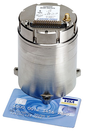
MEMS INS/GPS
Update improves heading performance and reduces jitter
Photo: Systron Donner
The SDN500 digital quartz micro-electro-mechanical systems (MEMS) GPS inertial navigation system (GPS/INS) has been updated. Model SDN500-xE provides a newer generation JF2 (C/A) code GPS receiver and tightly couples the 1 PPS GPS signal to the SDI505 IMU synch pulse to improve heading performance and reduce jitter after long periods of operation without dynamic inputs. The 25-inch-square SDN500 provides for maximum packaging flexibility in dense systems and delivers accuracies to within 1.0 mrad in attitude, 0.1 m/s in velocity and 3.9 meters spherical error probability (SEP). It offers tactical-grade performance, integrating SDI’s latest quartz gyros capable of 0.5°/hr. bias in-run stability and low angular random walk (ARW, 0.02°/√ hr), quartz accelerometers delivering 0.5 milli-g in-run bias stability and low velocity random walk (VRW, 80 µg/√ Hz), plus high-speed digital signal into a tightly coupled GPS/INS for tactical navigation and geo-location applications.
Testing location accuracy performance of mobile devices
Photo: Rohde & Schwarz
To create test concepts for over-the-air (OTA) antenna measurements, Rohde & Schwarz and Bluetest have integrated the R&S LBS Server, a software component running on the R&S CMW500 wideband radio communication tester, and the Bluetest over-the-air (OTA) test solution for A-GNSS systems based on Bluetest’s RTS65 reverberation chamber and Bluetest’s Flow measurement software. The R&S LBS Server controls the Rohde & Schwarz base-station simulator R&S CMW500 for LTE, WCDMA and GSM, and uses the R&S SMBV100B vector signal generator for simulation of GNSS and metropolitan beacon systems (MBS) signals. An upgrade for 5G will be available soon. The R&S LBS Server is an essential part of the R&S TS8991 OTA Performance Test System.
Brings Navsight technology to the most demanding environments
Photo: SBG Systems
The Horizon IMU adds a third choice to SBG System’s Navsight Land/Air Solution. It is a FOG-based high-performance inertial measurement unit (IMU) designed for highly demanding surveying applications such as high-altitude data collection or mobile mapping in dense areas such as urban canyons. The Horizon IMU joins the Ekinox and Apogee IMUs as options for Navsight. The different levels of accuracy enable the solution to meet various application requirements and can be connected to various external equipment such as odometer, lidar and more. The Horizon IMU allows customers to use Navsight in high-altitude and highly dense areas, as well as where only a single antenna can be used. It is based on closed-loop FOG technology that enables ultra-low bias and noise levels. The Navsight solution can be installed in a plane or car — the sensor alignment and lever arms are automatically estimated and validated. The Navsight unit also integrates LED indicators for satellite availability, real-time kinematic (RTK) corrections and power. Qinertia post-processing software provides access to offline RTK corrections from more than 7,000 base stations in 164 countries.
The Coach 4×4 Wi-Fi/DSRC GNSS multi-band antenna enables smart grids, mobile workforce communications, and advanced automation technologies. The dual-band 802.11ac/p MIMO antenna helps boost data rates and reliability for utility networks, intelligent transportation systems and other industrial internet of things (IoT) applications. The low-profile antenna features four-port 2.4/5-GHz coverage along with PCTEL’s high-rejection GPS/GLONASS technology for network timing and tracking in a single IP67-rated housing.
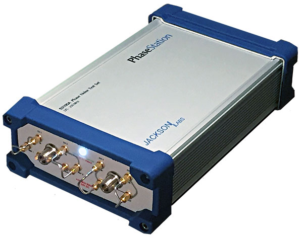
Jackson Labs Technologies has released the latest upgrades to its GPS simulator and transcoder product line.
Screenshot: Jackson Labs
The latest version of freeware application SimCon rev. 1.20 is now available. New features include:
Single-button GPS Week Number Rollover testing to test when GPS receivers will fail (hardly any will fail April 6; most older units will fail sometime between now and 2025).
Single-button GPS receiver leap second testing: Some GPS receivers might have an issue operating properly when the next leap second happens after the upcoming April 6 week number rollover, and SimCon makes that trivially easy to check.
Additional support for modern external GNSS receiver NMEA sentences for transcoding such as $GNGGA, $GLGGA, etc.
Improvements in GPS receiver switchover performance when switching from a fully GPS-denied area (running from INS) to GPS-available while transcoding in aircraft and vehicles.
This was fine-tuned based on extensive flight tests with the Navy/Air force.
Added support for the new Micro-Transcoder with its new Eval board.
Photo: Jackson Labs
Jackson Labs also announced a new product line, the PhaseStation ADEV Frequency Stability phase noise test system (signal source analyzer).
The test system is:
useful in testing signal performance in a host of products such as GPS or GNSS disciplined oscillators.
useful to qualify and evaluate local oscillator (LO) performance for GNSS receiver design, including GPS TCXO evaluation and parametrization.
stability measurements of 1PPS and arbitrary frequency outputs from GNSS receivers
useful in optimization of GNSS receiver Kalman filter design via the GNSS receiver 1PPS output signals.
automatically synchronizes and syntonizes (calibrates) the internal dual oscillator DOCXO option to external GNSS receivers via 1PPS input.
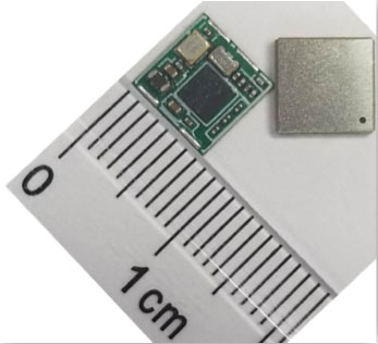
Allystar Technology Co. Ltd. has launched its smallest multi-band multi-GNSS module, the TAU-0707. Within its 7.6 x 7.6 millimeter size, the TAU-0707 series module supports major GNSS constellations (GPS / Galileo / GLONASS / BeiDou / QZSS / IRNSS) and all civil bands (L1, L2, L5, L6).
As the latest addition to Allystar’s GNSS portfolio, the TAU-0707 series module is a concurrent multi-band multi-GNSS receiver embedded with a cynosure III single-die standalone positioning chipset, which offers multi-frequency measurements to improve positioning accuracy and simplifies integration for third-party applications, said Shi Xian Yang, Allystar marketing manager.
Moreover, Allystar also provides the built-in low-noise amplifier in the TAU-1010 series module, which offers the module with improved RF sensitivity and exceptional acquisition and tracking performance even in weak signal areas.
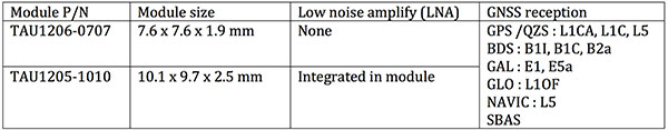
With more and more satellites supporting L1/L5 signals, Allystar offers two modules to fully support all civil signals on the L5 band for the standalone market. The TAU1206-0707 and TAU1205-1010 are expected to be better in multipath mitigation mainly due to the higher chipping rate of L5 signals relative to L1 C/A code.
L1/L5 band module for standalone market.
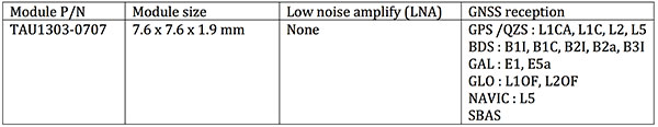
For professional applications, module TAU1303-0707 comes with built-in support for standard RTCM protocol (MSM), supporting multi-band multi-system high-precision raw data output, including pseudorange, phase range, Doppler, SNR for any kind of third-party integration and application.
Module with Raw data output for professional market.
Allystar TAU series module offers superior accuracy thanks to the onboard 26-MHz temperature compensated crystal oscillator and a reduced time to first fix relying on its dedicated 32-KHz real-time clock oscillator. Based on 40-nm manufacturing processes of the Cynosure III GNSS chipset, it comes with very low power consumption at less than 40 mA.
According to the company, engineering samples and a reference design of the Allystar TAU-0707 and TAU-1010 series module will be available in April.
Acquisition Expands Orolia’s Global Footprint into Canada.
Orolia has acquired Skydel Solutions, a GPS/GNSS signal simulation company based in Montreal, Canada.
Orolia made the announcement at the Association of the U.S. Army’s Global Force Exhibition in Huntsville, Alabama.
Orolia is a resilient positioning, navigation and timing (PNT) solutions company and a partner of U.S., NATO and allied forces. The company provides end-to-end resilient PNT solutions, including scalable, modular and cost-effective technology to support PNT-reliant and critical defense and commercial applications.
Skydel’s capabilities allows Orolia to offer customers more diverse resilient PNT solutions with sophisticated testing and simulation protocols, additional customized signals, and superior vulnerability assessments for military and commercial applications where GNSS failure is not an option.
According to Orolia, as the latest addition to the Orolia portfolio, Skydel brand solutions bring a new paradigm to the GNSS simulator scene by combining innovative algorithms and off-the-shelf hardware to help protect the world’s most critical GNSS-reliant systems operating through GPS, Galileo and other GNSS.
Skydel technology also supports secure communications signals such as SAASM, M-code, PRS and other alternative signals with approved partners to provide real-world PNT vulnerability testing for critical infrastructure applications worldwide.
“The need for continuous, reliable GNSS signals is growing exponentially worldwide, particularly for military and commercial systems that depend on accurate PNT data,” said Orolia CEO Jean-Yves Courtois. “The threats to these systems are growing too, whether it’s through signal jamming, spoofing or meaconing. With Skydel’s unique industry expertise, Orolia now offers even more rigorous, broad spectrum testing and simulation solutions to ensure continuous signals, even in GNSS-denied environments.”
By combining graphics processing unit (GPU) accelerated computing and software-defined radios (SDR), Skydel-powered simulation solutions generate signals in real time, with uncompromising performance for demanding use cases. They are available as complete turnkey systems suitable for all GNSS simulation needs, including everything from compact test benches to complete CRPA test systems.
“Since our inception in 2014, Skydel has enjoyed exponential growth,” said Stéphane Hamel, CEO of Skydel. “This strategic move with Orolia will allow us to keep our focus on disruptive innovation and accelerate our global reach.”
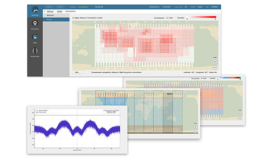
Above: A montage of screenshots showing the various updates, from a February 2019 story about Skydel updating its SDX GNSS simulator to version 19.1 with Galileo Alt-BOC and more. (Image: Skydel)