STMicroelectronics (ST) is making its Teseo III satellite navigation receiver accessible to a wider designer community by introducing the Teseo-LIV3F module, which integrates essential features to speed application development and also adds up to 16 MB of Flash memory for firmware updating or data logging without a backup battery.
Used by automotive and industrial sectors, ST’s Teseo III multi-constellation receiver combines high accuracy with fast response time and low power consumption, the company said.
The Teseo-LIV3F module now enables makers and small engineering teams without extensive in-house RF expertise to leverage the Teseo III advantages in creating new products in the industrial and consumer market segments such as vehicle trackers, drones, anti-theft devices and pet locators, and systems for services such as fleet-management, tolling, vehicle sharing or public transportation.
The 18-pin, 9.7 x 10.1 millimeter module contains the Teseo III receiver with on-chip power management, UART and I2C interfaces, alongside the Flash memory, an ultra-stable temperature-controlled crystal oscillator (TCXO), and 32kHz real-time clock (RTC).
The documentation and tools delivered with the module contain all the C code needed to drive the module using the STM32 microcontroller, including the use of data-logging, odometer and geofencing to aid development of value-added functionality.
While simplifying application development, Teseo-LIV3F delivers high performance, including -163 dBm tracking sensitivity and 1.5m positioning accuracy (CEP Circular Error Probability) and low-power operation (17µW in standby mode and 75mW when tracking). FCC and CE certifications streamline product testing and accelerates time to market.
Multi-constellation flexibility ensures robust, failure-resistant navigation worldwide, with access to the GPS, GLONASS, Galileo and BeiDou constellations, as well as the Pacific-region Quasi-Zenith Satellite System (QZSS).
The module supports assisted modes — including autonomous ST Assisted GPS (STAGPS) and server-based assisted-GNSS with free server access — to retrieve ephemeris data if satellites are unavailable for fast time to first fix (TTFF). The module also supports standardized augmentation systems to enhance accuracy, including the U.S., European, Japanese/South-East Asia, and Indian Satellite-Based Augmentation Systems (SBAS), and the Radio Technical Commission for Maritime Services (RTCM) differential GPS.
The Teseo-LIV3F module is available now as an 18-pin LLC device.
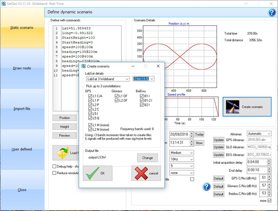
The software now includes simulation of the L2C and L5 GPS signals, meaning that SatGen V3 can be used to create one scenario containing all 13 signals from GPS, GLONASS and BeiDou constellations, the company said.
The simulation accuracy has also been improved — for example, most of the GPS pseudorange residuals are now sub-meter.
Signals that can be simulated simultaneously with SatGen V3 Wideband include:
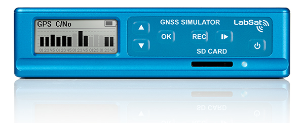
SatGen software allows users to create a GNSS RF I&Q or IF data file that can be replayed on a LabSat, which is based on a user-generated trajectory file. This allows simulators of almost any kind of test, at a set time and date, anywhere in the world.
SatGen complements the LabSat range of GNSS simulators, and is available in single, dual, triple and multi-frequency/multi-constellation versions.
LabSat showcased the upgrade at the ION GNSS+ conference, which took place Sept. 24-28 in Miami.
U-blox is collaborating with LynQ, which developed a location tracker that doesn’t use cellphones, networks, apps or monthly fees. By syncing up the devices before heading out, group members can find each other within a five-mile radius and link up again.
LynQ surpassed its fundraising target on the Indiegogo crowdfunding platform, raising more than $1.5 million, and is now on pre-sale.
The device uses the u-blox CAM-M8Q GNSS receiver, a GPS/GLONASS/BeiDou positioning module with an embedded antenna. With its slim size of 9.6 x 14 x 1.95 millimeters, it is easy to integrate it into handheld devices, u-blox said.
The first generation of the weather-proof tracker uses long-range, low-power radio frequencies to connect devices. Up to 12 people can join a group, split up, and use the only button on the clip-on device to toggle through the group members and find out in which direction and how far away each one is.
LynQ’s crowdfunding success shows the extent to which the company’s founders uncovered an unmet demand on the market. While smartphone-based solutions to locate friends and family, for instance in a crowd, abound, they are limited by the availability of mobile network reception.
LynQ’s location tracker helps friends regroup outdoors or at crowded events, parents keep an eye on their children, and caregivers watch over the safety of people with special needs, elderly family members, or loved ones suffering from diseases such as Alzheimer’s.
The tracker has been field-tested on numerous continents and in most topographies and use cases.
“We found the u blox CAM-M8Q to be the best solution for us to achieve the requirements our use cases demand,” said Drew Lauter, COO at LynQ. “We’re extremely price sensitive, yet we need a highly dependable GPS module; u-blox worked closely with us to deliver that.”
For u blox, accompanying LynQ in the development of its product has been an exciting adventure, said Suresh Ram, president of u-blox America. “We’re thrilled to see how well their idea has been received by the public and look forward to our continued collaboration in the future.”
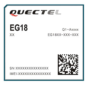
Quectel Wireless Solutions, a global supplier of internet of things (IoT) modules, has launched the EG18, an LTE Category 18, high-speed module that offers 1.2Gbps downlink and 150Mbps uplink peak rates.
EG18 module. (Photo: Quectel)
The EG18 supports Qualcomm IZat location technology Gen8C Lite (GPS, GLONASS, BeiDou, Galileo and QZSS). The integrated GNSS greatly simplifies product design, and provides quicker, more accurate and more dependable positioning capability, Quectel said.
Based on Qualcomm’s SDX20 chipset and fully compliant with 3GPP R12 specification, EG18 supports wireless technologies such as carrier aggregation (CA), 4×4 multiple-input multiple-output (MIMO) technology and 256QAM.
Quectel EG18 is a series of LTE Advanced modules optimized specially for M2M and IoT applications which support industrial operating temperature range of -40 to 85˚C.
The EG18 is designed for ultra-high-speed industrial routers, in-vehicle video surveillance systems, cloud-based 4K IP-cameras and other applications that require very high throughput and low latency.
EG25-G module. (Photo: Quectel)
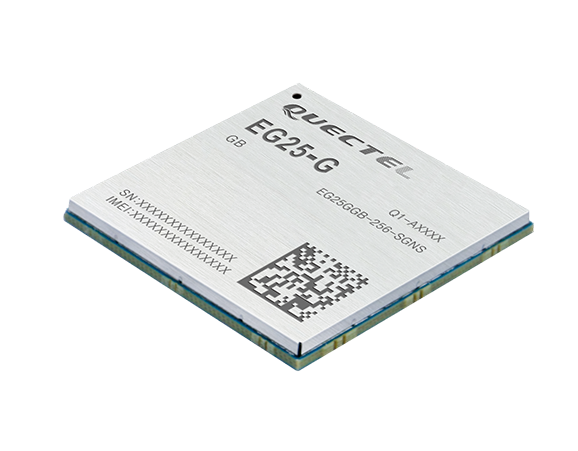
EG25-G module. Quectel also launched an LTE Cat 4 module to provide global connectivity on up to 30 bands with LTE, 3G and 2G coverage all from a single SKU. This “all-in-one” module EG25-G is designed to improve the efficiency of global IoT deployment at optimized cost.
EG25-G is the latest addition to Quectel’s comprehensive LTE portfolio based on Qualcomm MDM9x07 chipset. Adopting the 3GPP Release 11 LTE technology, it delivers 150 Mbps downlink and 50 Mbps uplink peak data rates, with an optional GNSS receiver including GPS, GLONASS, BeiDou, Galileo and QZSS to provide quick and accurate positioning, the company said.
The new module supports FDD LTE frequency bands of B1/B2/B3/B4/B5/B7/B8/B12/B13/B18/B19/B20/B25/B26/B28, TDD LTE bands of B38/B39/B40/B41, WCDMA bands of B1/B2/B4/B5/B6/B8/B19 and quad-band GSM/EDGE. This ensures devices with EG25-G inside can operate on networks of major global carriers like AT&T, Verizon, Telstra, Vodafone and T-Mobile. The EG25-G supports multi-carrier switch by detecting (U)SIM card.
Designed in a compact LGA form factor measuring 29.0×32.0×2.4 mm, EG25-G is pin-compatible with Quectel’s EC2X family, allowing flexible migration. It also offers Mini PCIe form factor with built-in sim card holder to provide a better plug-and-play experience.
“A growing number of today’s IoT developers tend to design and manufacture devices that can operate globally with a single hardware design. Our EG25-G was created to address such needs,” said Delbert Sun, Quectel product and marketing director. “We are pleased to see that customers will achieve simplified production and testing processes, and save distribution costs due to the need for just one single SKU.”
EG25-G has a rich set of Internet protocols, industry-standard interfaces, abundant functionalities and extended life cycle, and is designed for verticals including industrial routers, industrial PDA and video surveillance.
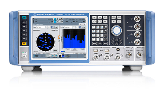
Rohde & Schwarz has added GPS L5 and Galileo E5 simulation capabilities to its R&S SMW200A GNSS simulator.
The R&S SMW200A GNSS simulator is designed for efficient test and characterization of multi-constellation and multi-frequency GNSS receivers. With its additional simulation capabilities for GPS L5 and Galileo E5, the R&S SMW200A enables generation of complex and highly realistic test scenarios with up to 144 channels in the GNSS frequency bands L1, L2 and L5, the company said.
In addition to GPS (L1/L2/L5), GLONASS (L1/L2), Galileo (E1/E5) and BeiDou (L1/L2), the R&S SMW200A also supports signal generation for QZSS and SBAS on L1. The available channels can be routed to up to four RF outputs, so that even multi-antenna systems can be tested.
Apart from its new GNSS simulation capabilities, the R&S SMW200A can generate complex coexistence and interference scenarios with multiple interferers. GNSS signals, noise and all interference signals are generated directly in the instrument. Additional signal sources for external generation of interference signals are not required, resulting in small, compact and simple test setups.
Launched in 2017, the R&S SMW200A can be turned into a high-end GNSS simulator and is able to internally simulate complex interference environments in parallel with GNSS signals.
An increasing number of GNSS receivers are capable of receiving signals on multiple different frequencies, such as L1, L2 and L5. Although this multi-frequency capability, as well as having to process signals from diverse navigation systems such as GPS, GLONASS, Galileo or BeiDou, make the receiver design more complex, they ensure a better quality of service for the end user.
According to the company, multi-frequency and multi-constellation processing not only improves positioning accuracy, service availability and robustness, it also makes the positioning process less vulnerable to interference, jamming or spoofing attacks.
The R&S SMW200A with its new GNSS simulation capabilities will be showcased at the ION GNSS+ 2018 trade show in Miami.
As Hurricane Florence rattles along the coastlines of the Carolinas and Georgia creating havoc, everything that flies is grounded. Right now the hurricane has slowed to a tropical storm, but flooding is extensive and people have died.
As soon as the high winds subside, expect almost all first response groups to put up UAVs to begin damage assessment. Digital images gathered by these drones will assist forward personnel to direct recovery and rescue operations. FEMA and other search and rescue teams, already in place along the track of the storm, have begun to rescue people by boat and are expected to fly drones over other inaccessible areas to find survivors.
And, of course, a significant part of the coverage we will see over the next week or so will come from drone-borne TV cameras and links to network uplink vans. We should also expect drones to be used for significant data gathering to map affected areas for damage to homes and infrastructure — including powerlines, radio and cellphone towers and distribution centers, waterways, roads and railways.
Let’s hope that the lessons learned and experience gathered during the major storms of last year will help everyone operating drones assist in minimizing the time to rescue people and to speed recovery from this latest hurricane. Later, expect the insurance companies to arrive with UAVs to assess damage and verify claims.
Police forces are using drones…
The law enforcement office in Dauphin County, Pennsylvania, has been using a drone for several months. With more than 13 investigations completed, the drone has helped locate one lost individual and has also supported crime-fighting.
Rather than calling out a manned helicopter for assistance, the police are able to get a drone in the air within 20 minutes at much less cost.
FAA regulations govern how Dauphin County law enforcement officials fly their drone, including a waiver granted to allow night-time operations.
…while Colombia is testing drones to destroy coca plants.
Recent growth in Colombian coca cultivation to 516,000 acres during 2012-2017 came as a consequence of the end of a government program to fumigate coca fields. Crop-duster planes spraying glyphosate had previously reduced Colombia’s coca fields from 470,000 to 193,000 acres during 2001-2012, according to U.S. figures.
Meanwhile, U.S overdose deaths from cocaine are continuing to increase, while rebels and drug traffickers have apparently shot down several crop-dusters.
Lawsuits against the use of the chemical glyphosate have also been successful. Over-spray is alleged to have killed other, legal crops, and opponents also cited a recent ruling in California that awarded $289 million in damages to a groundskeeper who said glyphosate-based weed killers had caused his non-Hodgkin lymphoma.
Because of concerns, Columbian police have been testing drones — flying a couple of feet above the plants to mitigate over-spraying of defoliants — to kill coca crops and reduce the supply of cocaine. Apparently, 10 remotely guided drones, each weighing 50 pounds fully loaded, destroyed hundreds of acres of coca in the first phase of tests. Though common in agriculture for the monitoring of crop growth, it’s thought that drones have never before been used to kill illegal crops. The fumigation appears to be about 90% effective to date.
Nevertheless, in Colombia’s drug zones, soldiers will be needed to partition swaths of coca-producing land and to defend operators from angry farmers and drug traffickers. There are also land mines which will need to be overcome from Colombia’s long rebel conflict and which pose a danger to drone operators.
Counter UAS (C-UAS) systems are on the rise.
The Drone Dome system uses Laser, RF and Radar. (Photo: Rafael)
As fast as drone technology is developing, counter UAS (C-UAS) systems are also being put in place to prevent unwanted drones from penetrating the air above sensitive facilities — by detecting and disabling them. There are purportedly more than 60 such C-UAS systems available in the U.S., with more in other countries including China and Russia.
Systems use various technologies for detection — such as radar, laser, optical/IR, RF “sniffer,” and acoustic. Drones can be disabled by RF and GNSS jammers, by spoofing of both the GNSS navigation or the control link, and can be brought down physically by high-power lasers, nets deployed by other drones, collisions by attack drones, by regular or specialized anti-drone gun systems and even by high-pressure water cannons for very close-in defense. Anti-drone systems include detection and take-down dome-based systems and man-portable drone guns.
SpotterRF C-UAV radar. (Photo: UAS Vision)
The UK government has acquired the Drone Dome C-UAS (counter-UAS), manufactured by Rafael, Israel. Detection is provided by an S-band radar (four radars provide all-round coverage), an electro-optical/infrared (EO/IR) surveillance suite, and a wideband RF sensor.
Drones can be disabled by a high-power laser, an RF jammer, or when very close-in by a high-pressure water gun. The UK system is expected to use jamming to bring down drones and doesn’t include the high power “hard-kill” laser option.
Depending on the size of the intruder drone, the radar detection range is around 3.5-10 kilometers, and the radar may also disable a UAV when integrated with the RF jammer. With an active electronically scanned array antenna, the radar is relatively small and light-weight for both fixed and mobile installations.
The DroneGun. (Photo: DroneShield)
Another C-UAV offering, from SpotterRF, claims to solve the problem of requiring multiple radar elements to achieve 360-degree “dome” coverage. The 3D-500 radar enables full “dome-drone” detection from 0 to 90 degrees vertical and 360 degrees horizontal using a single radar with a 500-meter detection radius, yet weighs only 12 pounds.
Latitude, longitude and altitude of intruder targets are measured within a 1-kilometer diameter hemisphere dome. Following radar detection of an unauthorized drone, the system may be augmented by a slew-to-cue optical/IR camera providing a visual display to an operator — a directional RF jammer on a pan/tilt turret can then be activated to take-down the intruder. The system operates automatically to both detect and disable the drone, or manual control is possible to enable initial operator confirmation of the target before take-down is activated.
DroneShield out of Australia markets a drone detection and mitigation system probably best known for its DroneGun. The DroneGun is a point and shoot device able to disrupt multiple RF frequency bands simultaneously (433 MHz, 915 MHz, 2.4 GHz and 5.8 GHz), taking out the communication link to a drone operator — and also GNSS signals when so equipped — up to 1 kilometer away.
The full DroneSentry detection system integrates a suite of sensors and countermeasures including radar, optical, RF listening, acoustic, thermal and an RF countermeasure transmitter with greater power and range than the portable DroneGun.
Another example is the Rex-1 drone gun. Operating in the 2.4 GHz and 5.8 GHz bands, the Rex-1 rifle-like drone-disabling device is a man-portable jammer developed by Russian Kalashnikov Group subsidiary ZALA Aero Group.
https://youtu.be/Px56KtpZ004
Mapping and survey are becoming a major application for drones.
One such example is 3D mapping of a copper mine in only three days using a fixed-wing UAS.
At an altitude of 1,400 meters, the Erdenet open-pit mine in Mongolia extends 5 x 2 kilometers and is more than 200 meters deep in places. Despite strong winds and even some snow in May this year, one UAS quickly captured geospatial data that enabled three-dimensional modeling of the large, complex site.
Site management is expected to use this initial model as a baseline against which future drone-maps will be compared, and to plan future mine operations.
However, extensive preparations over a two-week period were still required, including the installation of 21 ground control points, positioned using GPS RTK measurements. Re-verification of these points was also required from time to time before the survey, due to changes in the mine from ongoing mine operations, including dynamite blasting.
A MAVinci Sirius UAV was used to gather almost 7,000 aerial photographs which were processed through Agrisoft Photoscan Pro software to produce a detailed digital surface model. All the data collected will be used to create various internal views of the mine for continued mining operations. The mine produces about 26 million tons of ore each year, leading to approximately 530,000 tons of copper and 4,500 tons of molybdenum derivatives.
UAVs make medical deliveries.
Some U.S. medical facilities will soon be participating in a Department of Transportation test program to transport medical samples and supplies by UAV — the object being to obtain test results and medical supplies much quicker than at present. Matternet, Zipline and Flytrex — UAV companies already involved in deliveries by drone — will use several different UAVs in the program, which also aims to set up a number of medical distribution centers.
Matternet has been delivering medical supplies by drone in Switzerland, and Flytrex is focusing on food and package deliveries.
Delivery drone in Kasungu, Malawi. (Photo: AFP)
Meanwhile, Zipline and UNICEF have established an “air corridor” in the city of Kasungu in Malawi to test the transport of medical supplies by drone. Rwanda had previously used UAVs to deliver medication in Africa. Other underdeveloped countries without good ground infrastructure could well benefit by using life-saving drone deliveries for urgently needed medication.
Supporting police investigations, mapping of mines, and coca crop destruction all seem to be good examples of newer uses for unmanned air vehicles. And when policing of drone intrusion is required, looks like there are many new options to detect, disable and even take down unwanted drones. I’d say we seem to be making good progress towards better acceptance and that the industry is starting to grow up.
And let’s all hope that the efforts of all first responders in the Carolinas and Georgia continue through the many weeks of recovery from flooding and damage that are still to come, and that people can soon get back into their homes.
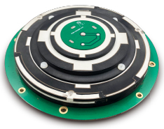
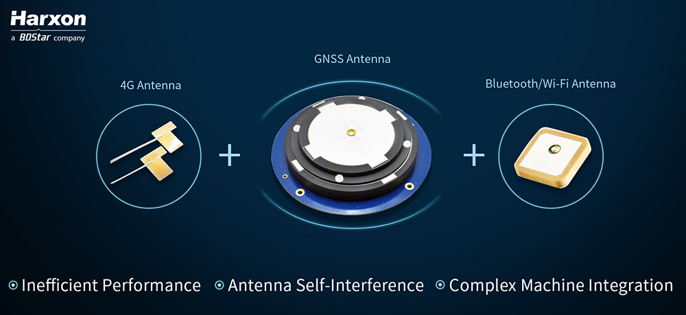
Real-time kinematic (RTK) integration usually uses separate antennas, which can lead to reduced efficiency because of electro-magnetic interference (EMI).
Image: HarxonImage: Harxon
Also, conventional antenna installation can result in unstable machine performance because of the problems of system compatibility between different antennas.
Harxon has overcome those difficulties with its integrated X-Survey antenna, a 4-in-1 OEM antenna for both navigation and communication in surveying applications.
It provides standard Wi-Fi, Bluetooth and 4G, plus multiple constellation signal reception for GNSS positioning.
The high-gain and wide-beamwidth GNSS antenna features a multi-point feeding technology, ensuring a high phase-center stability and positioning accuracy, the company said. Moreover, the array-arranged 4G antennas enables more stable signals and longer communication distance at 360-degree direction, increasing the overall machine efficiency over conventional antennas.
The X-Survey antenna provides high isolation among each antenna to prevent self-interference, improving RTK system compatibility. RF coaxial connectors are designed for plug-and-use, keeping high efficiency and lowering the impact of EMI.
The antenna low-noise amplifier features excellent out-of-band rejection performance, which can also suppress the EMI, providing reliable GNSS signals.
The unique structure design simplifies RTK integration, and minimizes the overall machine dimension. Harxon aims to bring system integrators high-efficiency performance of navigation and communication in surveying and precision agriculture applications.
4G bands can be customized according to different countries and regions, the company added.
New research conducted at the University of Otago, New Zealand, and published in the August issue of Journal of Geodesy demonstrate that it is possible to achieve centimeter(cm)-level precise positioning on a smartphone.
The research, conducted in collaboration with Curtin University, Australia, combined signals from four different GNSS, according to Otago’s Dr. Robert Odolinski and Curtin University colleague Prof. Peter Teunissen.
“It’s all down to the mathematics we applied to make the most of the relatively low-cost technology smartphones use to receive GNSS signals, combining data from American, Chinese, Japanese and European GNSS. We believe this new capability will revolutionize applications that require cm-level positioning,” Odolinski says.
He said to understand the new technology, a look back at the historical scientific context is needed.
Precise centimeter-level positioning on a smartphone during 24 hours in Dunedin, New Zealand. Blue dots show repeatability of one epoch data in comparison to precise benchmark coordinates. The repeatability is more or less the size of a one-dollar New Zealand coin (diameter of 2.3 cm) in all three dimensions. (Image: University of Otago)
“For decades, construction, engineering, cadastral surveying and earthquake monitoring have relied on high-cost, dual-frequency GPS positioning to obtain centimeter-level location information. The challenge is that GPS signals, traveling from Earth-orbiting satellites to receivers on the ground, are disrupted along the way, and this generates errors and limiting precision.
“The traditional solution is to combine GPS signals sent at two different frequencies to improve the positions, but the antennas and receivers required have been expensive, far beyond the reach of many who would benefit from the technology,” Odolinski said.
The new approach uses only one of two frequencies but collects data from more satellites for a multi-constellation GNSS solution. The extra data and algorithms are used to improve the positions without adding cost.
Odolinski and Teunissen have shown that this approach can work in smartphones, producing competitive results compared to dual-frequency GPS solutions (see figure).
Odolinski believes that countries and industries of all sizes can benefit from using smartphones as GNSS receivers, and is confident commercial application and development will spring from this research.
“This significant reduction in costs when using smartphones can increase the number of receivers that can be deployed, which will revolutionize a range of disciplines requiring centimeter-level positioning, including precise car navigation, surveying and geophysics (deformation monitoring), to name a few.”
MEMS-based sensing solutions company Acienna released OpenIMU, a professionally supported, open-source GPS/GNSS-aided inertial navigation software stack for low-cost precise navigation applications.
Integrating an inertial measurement unit (IMU)-based sensor network will greatly improve its navigation and self-location capabilities, Acienna said.
It is aimed at developing autonomously guided vehicles for industrial applications, autonomous cars, factory or industrial robots, drones, remotely operated underwater vehicle or any kind of smart machine that needs to move fast or slow, on land, in the air or in water.
“Our breakthrough open-source software for INS/GPS algorithm development is the first professional grade open-source navigation stack running on a low-cost IMU,” said Mike Horton, CTO of Aceinna. “Not only will this kit save developers time and money, it is simple to use and does not require a Ph.D.”
OpenIMU enables advanced, easy-to-deploy localization and navigation algorithm solutions for a fraction of the time and cost of traditional methods, Aceinna said.
OpenIMU’s combination of open-source software and low-cost hardware enables rapid development of advanced solutions for drones, robotics, and autonomous applications. Its extensible software-infrastructure provides all the code needed for algorithm development.
The freely downloadable stack includes:
FreeRTOS-based data collection and sampling engine
Free IDE/compiler tool chain based on Visual Studio Code
JTAG debugging for debugging code loaded on IMU
Data logging, graphing, Allen Variance plots and maps
Extensive documentation
Robust simulation environment with advanced sensor error models
To install OpenIMU stack now, follow the directions. Several ready-to-install free GPS/INS and IMU applications are available at Aceinna’s Navigation app store.
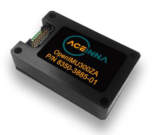
The OpenIMU Development hardware development kit includes JTAG-pod, precision mount fixture, EVB and an OpenIMU300 module.
The OpenIMU module features Aceinna’s 5 deg/Hr, 9-Axis gyro, accelerometer, and magnetometer sensor suite with an onboard 180-MHz ARM Coretex floating-point CPU.
The IMU is delivered in a 24 x 37 x 9.5 millimeter module that operates at 2.7-5.5 VDC.
The OpenIMU Development kit is available for immediate delivery.
The toolset is a rapid-prototyping platform that lets product designers test and optimize the position accuracy and power consumption of wireless location tracking applications that use LTE-M and NB-IoT cellular networks, as well as GNSS technology. The toolset targets product engineers working on battery powered applications such as sport, people and asset trackers.
An increasing number of battery powered consumer and industrial products feature integrated GNSS receivers. These products include virtual reality headsets, smart watches, and devices to track elderly people, containers or parcels.
With the ongoing roll-out of low power wide-area cellular networks (LPWAN) such as LTE-M and NB-IoT technologies around the world and the extremely low power consumption they enable, the range of use cases for wireless location trackers is expected to expand further.
Screenshot: u-blox
“With today’s technology, product designers can now include optimized battery life in their applications,” said Florian Bousquet, product manager, Product Center Positioning, at u-blox.
“We developed this toolset to give customers a quick and easy way to test the accuracy and the power consumption of their product ideas using the latest generation of our technology,” he said. “In many cases, they can replicate their applications and start testing the performance of different device configurations in under 15 minutes.”
“The toolset offers access to the very latest technologies, from LTE-M and NB-IoT cellular communication to our proprietary Super-E mode(see video below) that delivers the best balance between power consumption and GNSS positioning performance,” he added.
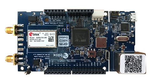
The u-track software runs from embedded firmware on the new u-blox C030-R410M application board. The board, specifically designed to rapidly prototype applications for the internet of things (IoT), includes an ultra-small, low-power u-blox ZOE-M8B GNSS receiver and a size-optimized SARA-R410M LTE-M/NB-IoT cellular communication module.
Additionally, u-track includes a PC software application. Its user-friendly dashboard lets users log, retrieve, and visualize power consumption, accuracy, and other important values, such as the time it takes the GNSS receiver to calculate a position (time-to-first-fix, TTFF).
The u-track and C030-R410M toolset will be showcased on Sept. 12-14 at Mobile World Congress Americas, u-blox Booth no S.2702.
Galileo, BeiDou, QZSS, IRNSS, and more join GPS and GLONASS to bring you wider, broader, greater, more accessible and above all more accurate PNT. How to get all that’s coming at you?
Multi-GNSS paves the way for complete exploitation of new signals and constellations in navigation, surveying, geodesy and remote sensing.
The free 1-hour webinar, which will take place at 1 p.m. Eastern [10 a.m. Pacific, 7 p.m. (1900h) Central European Time] on Thursday, Sept. 20, will review advantages of using multi-GNSS for the end-user and challenges in obtaining maximum efficiency when combining multiple constellations and signals. It will also discuss different approaches of testing GNSS receivers against jamming and spoofing attacks.
You will learn:
Advantages of using multi-GNSS
Challenges when combining multiple constellations
Robustness of multi-GNSS receivers to jamming and spoofing
Test solutions for GNSS receivers.
The webinar presents sponsored content by Skydel and Talen-X. Register for it here.
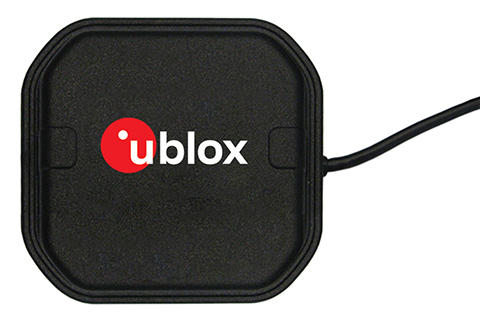
U-blox, a global provider of positioning and wireless communication technologies, has released the ANN-MB multi‑band active GNSS antennas, tailored specifically to the needs of applications requiring centimeter-level positioning accuracies.
The ANN-MB series. (Photo: u-blox)
ANN-MB offers product designers an easy-to-implement and reliable multi-band antenna solution, u-blox said. It is designed for small- to medium-size customers with little experience with GNSS antennas who would like to accelerate their time to market.
The ANN-MB antenna series builds on u‑blox’s two decades’ worth of experience with high-performance antennas for GNSS receivers. Developed in conjunction with the recently announced u‑blox F9 multi-band high precision positioning platform, ANN‑MB receives signals on the L1 and L2/L5 bands of all four global navigation satellite constellations (GPS, GLONASS, Galileo and BeiDou).
The antenna features versatile mounting and connector options (SMA, SMB, MCX) and supports an extended temperature range (up to 105 degrees Celsius), making it suitable for applications subject to extreme temperatures, the company added.
“With the u‑blox F9 platform, we took a major step in bringing down the cost of ownership of high-precision GNSS technology, such as our recently announced u‑blox ZED‑F9P module,” said JunJun Lu, senior engineer of product management, Product Center Positioning at u‑blox. “The ANN-MB multi-band antenna series takes this effort one step further, paving the way for new high precision positioning applications in the consumer and industrial markets.”
A limited number of ANN-MB-00 (SMA) prototypes are available now, with production of the ANN-MB series planned for December.