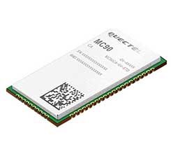
According to the company, the module supports hybrid positioning technologies including GNSS, Cell ID and Wi-Fi aided positioning, and enables position tracking in both indoor and outdoor environments.
Quectel’s MC90 integrates the multi-GNSS system, including GPS, GLONASS, Galileo and QZSS, which makes it suitable for urban areas with high-rise buildings and complex environments, the company added.
The MC90 also adopts Wi-Fi hotspot positioning technology for blind spots and satellite coverage. It integrates multi-aiding positioning technologies to offer customers with optimized GNSS performance. It also supports EPO technology, which provides predicted Extended Prediction Orbit to speed up TTFF without the need of any extra server.
The MC90 features a compact design, low power consumption and supports dual SIM single standby function. According to Quectel, it can be used for a wide range of internet of things applications, including bicycle sharing, student ID card, vehicle tracker, wearable device, pet tracker, asset tracker, driving recorder and more.
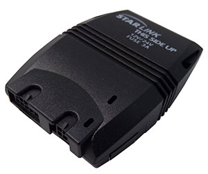
Automotive technology provider ERM Advanced Telematics has launched the StarLink Tracker with Wi-Fi, which integrates advanced vehicle tracking, driver behavior monitoring, theft prevention, Bluetooth, Wi-Fi and 4G cellular capabilities in a single device.
The company’s products have been installed in more than 1.5 million vehicles worldwide, the company said.
The StarLink Tracker with Wi-Fi is the first product under ERM’s new Wireless Connect strategy, which aims to use wireless technologies to provide its partners — vehicle fleet management companies, vehicle manufacturers and importers and car insurance companies — with a competitive edge.
The StarLink Tracker is a modular solution that is designed for installation both in vehicles on the production line and in the aftermarket, for vehicles that have left the production line. It turns any vehicle in which it is installed into a connected car.
The modularity of the product allows the addition of capabilities anytime through the use of add-on products provided by ERM or by a third party. This can be done on demand and without any need to replace the StarLink Tracker device, which keeps functioning as the central tracking and communications unit under any such solution.
The StarLink Tracker with Wi-Fi took about a year to develop, and ERM has already received its first orders to supply the product from customers in the United States, India and Australia.
The 120-gram tracker creates Wi-Fi hotspots in the vehicle for up to eight devices. It features a GPS/GLONASS/Galileo location module and an ability to navigate inside underground parking lots or in mines; a 4G cellular modem; internal antennas, emergency button support and built-in data logger.
Other capabilities are internal management of up to 500 driver IDs, remote immobilization, wireless connectivity to a wide range of additional ERM and third-party products and many other features.
As the core infrastructure for a Connected Car applications, the product can integrate to full range of the vehicle’s internet connectivity needs, which are provided by the use of the tracking unit’s SIM card without the need for any additional SIM card, the company said.
The StarLink Tracker with Wi-Fi and products that ERM Advanced Telematics will launch in the future under its Wireless Connect strategy, can be installed using the installer’s standard smartphone which communicates through Bluetooth connection in order to configure the product and perform any required adaptations. All this can be much faster compared to many other telematics devices and with much less hassle that might have arised due to the need to hook-up and hide wires.
The StarLink Tracker with Wi-Fi is also equipped with a microphone and loudspeaker to initiate and receive calls and dial emergency numbers. One application for this can be E-Call (Emergency Call), such as in the European Union or just as an Emergency Call application.
When pressing the location unit’s emergency button or immediately after an impact above a certain intensity, the unit will allows conversation between the vehicle’s occupants and the emergency center personnel, who can hear what is happening in the vehicle and identify events such as threats against the driver or accidents.
The product will also provide information about the driver’s behavior, including careless driving, accidents, off-road driving, acceleration during turns, speed violations and more, information that can be used by the manager to significantly improve fleet management capabilities, performance and can decrease operational expenses.
CHC Navigation has acquired the business assets and personnel of AMW Machine Control Inc. The business will now be conducted by AMW Machine Control Solutions Inc. as a subsidiary of CHC Navigation.
AMW Machine Control Solutions has more than 30 years of advanced machine guidance, machine control and GNSS experience. Its topographic and machine-control software solutions include grade, dirt, ditch, pipe, landfill and road. AMW Machine Control Solutions offers cost-effective solutions designed for equipment operators, the company said.
The offerings of AMW Machine Control Solutions will be based on turnkey, wireless CHC Navigation Android industrial tablets and CHC Navigation’s RTK GNSS receivers.
AMW Machine Control Solutions has appointed Phil Gabriel as president. Gabriel has more than 25 years of experience in the positioning industry. He previously served as president of Hemisphere GNSS Inc. and is currently serving as the general manager for CHC Navigation North America.
With these changes, CHC Navigation said it is poised to significantly grow its global market share in the agriculture civil engineering and construction industry, with products catering to small, medium and large enterprise farming and construction equipment users.
“Our customers really like CHC Navigation’s positioning products and their new Android tablets,” said Mark Williams, founder of AMW and now director of product management. “We have redeveloped our popular applications from the ground up to run Android while being more intuitive and wireless, wherever possible. With standardized hardware, AMW Machine Control Solutions will be able to better support our existing customers and to attract new ones.”
“AMW has been innovating in-machine control for many years. We are pleased to combine forces to offer the market incredible value and simple to use products,” Gabriel said.
A roundup of recent products in the GNSS and inertial positioning industry from the August 2018 issue of GPS World magazine.
OEM
IP Solution
With multi-constellation GNSS for internet of things (IOT) devices
The Dragonfly NB2 is a highly integrated and modular IP (internet protocol) solution optimized for Cat-NB2 (3GPP Release 14 eNB-IoT) that can seamlessly be incorporated into chips and modules by the multitude of companies looking to address the large and fast-growing cellular IoT space. GNSS hardware package. For customers developing NB-IoT products that also require GNSS capabilities, Ceva-Dragonfly NB2 includes a new power-optimized GNSS hardware package, with GNSS RF receiver and multi-constellation digital front-end. The GNSS package speeds up both acquisition and tracking tasks by up to 8 times compared to Ceva-Dragonfly NB1, enabling a host of popular NB-IoT use cases, including people, livestock and asset tracking and geofencing.
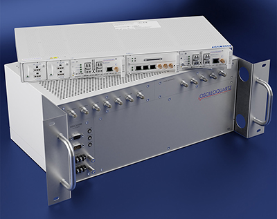
Provides timing accuracy and stability when GNSS signal is lost
Photo: Oscilloquartz
Oscilloquartz has launched its enhanced primary reference time clock (ePRTC) system to enable a high level of timing accuracy and stability, even when the GNSS signal is lost. The system provides a timing source for mission-critical transport systems, such as utility networks, government infrastructure and radio access networks, and provides the strict synchronization needed for LTE-A and 5G applications. Featuring the OSA 3230B ePRC atomic cesium clock connected to an Oscilloquartz clock combiner and grandmaster, the new solution offers the extremely stable frequency of a cesium clock with the UTC-traceable signal provided by GNSS. When combined with the OSA 5430, the OSA ePRTC system provides full hardware redundancy and multiple fan-out options including PTP over 10 Gbit/s.
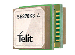
The SE878Kx-A series of GPS and GNSS integrated antenna receiver modules offer high performance, maximum reliability and low power consumption for consumer and business applications. The SE878K3-A and SE878K7-A are compatible with GPS, GLONASS, Beidou and Galileo and also enable device vendors to develop quickly and cost-effectively location-based IoT solutions for use in virtually any country worldwide. The SE878Kx-A series supports dual internal-external antennas to ensure connectivity when one is broken or compromised, along with a SAW filter to maximize jamming immunity. The modules are designed for mission-critical applications and other use cases where reliability is key, such as alarms, stolen cars or high-end asset tracking. The series also provides seamless integration with Telit’s cellular modules, including eCall/ERA-GLONASS compliant solutions.
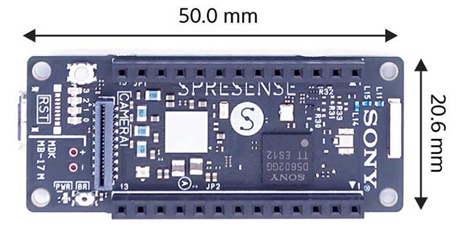
The Spresence main and extension boards are designed for internet of things (IoT) applications. The main board uses a multi-CPU structure equipped with Sony’s GNSS receiver (GPS+GLONASS) and high-resolution audio codec. A variety of systems for applications such as drones and other IoT devices can be built by combining the boards and developing the relevant applications. The boards’ software and hardware is available via open platform, allowing for a wide range of developmental possibilities. The main board can be used to control a drone using GPS positioning and a high-performance processor, voice-controlled smart speakers and low-power consumption sensing cameras. It also can be combined with sensors for use in systems that detect errors in production lines on the factory floor.
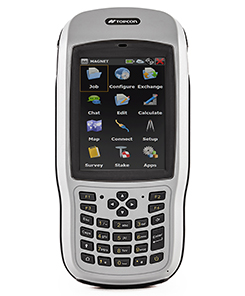
Designed for geopositioning, construction and mapping
Photo: Topcon
The T-18 handheld controller has a 3.7-inch sunlight-readable display, a 1-GHz processor and 1 GB of internal storage. For field data collection using Topcon’s MAGNET software, the T-18 offers a durable ergonomic solution with fast processing, excellent connectivity and a long (10-hour) battery life. It has a 3.5G cellular modem for connectivity with Topcon MAGNET solutions for sending and receiving data to the cloud company account. The modem also can be used for real-time kinematic (RTK) correction services. Other features include Bluetooth and an IP65 rating for dust and water protection in demanding job-site conditions.
The SXblue ToolBox is an Android application for SXblue GNSS receivers, enabling users to view and analyze the position data and metadata related to its location. The user can send commands that enable or disable some features, including systems in use, mask angle or differential angle, and constellation in use, including GPS, GLONASS, Galileo, BeiDou and SBAS. The SXblue ToolBox is also an NTRIP client capable of connecting to a NTRIP server for real-time kinematic (RTK) corrections, allowing the receiver to issue very accurate location information. The application can record, save and transfer raw data from the GNSS receiver, allowing post-processing on computers for surveying and geomatics professionals.The toolbox has been developed with special consideration for modern mobile devices and attention to user and dealer feedback. It includes a series of configurable audible and visual alarms for determining the thresholds of the information provided by the SXblue GNSS receiver.
The Leica RTC360 laser scanner is equipped with edge computing technology to enable fast and accurate creation of 3D models in the field. It combines high-performance laser scanning, edge computing and mobile app technologies to preregister captured scans quickly and accurately. With the push of a button, two million points per second of high dynamic range imagery can be captured to create a full-dome scan in under two minutes. It features a visual inertial system that automatically tracks movements between setup positions. The scans captured can be combined and preregistered on a mobile device, where they can be viewed and augmented with information tags.
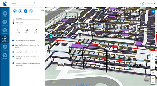
Location technology allows users to see rooms, gates and offices
Screenshot: Esri
ArcGIS Indoors is designed to enable interactive indoor mapping of corporate facilities, retail and commercial locations, airports, hospitals, event venues, universities and more. The solution applies the latest location technology to allow users to see and share where assets, rooms, departure gates and offices are located. It uses data streams, real-time processing and location intelligence tools to help businesses and other organizations understand how to better coordinate space and other resources with their facilities and campuses. Insights from sensor networks deliver real-time information to managers and executives through interactive dashboards, while visitors and employees can find useful information about the buildings they occupy. The solution also allows users to quickly access and explore critical business information, such as the location and status of fire extinguishers and their last inspection dates.
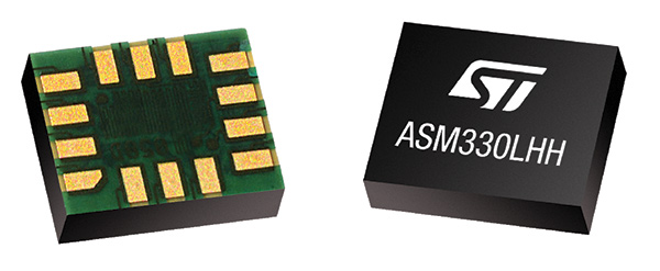
Meets demands for continuous, accurate vehicle location
The ASM330LHH module. (Photo: STMicroelectronics)
The automotive-grade ASM330LHH six-axis inertial sensor is designed for super-high-resolution motion tracking in advanced vehicle navigation and telematics applications. It lets advanced dead-reckoning algorithms calculate precise position from sensor data if satellite signals are blocked, such as in urban canyons, tunnels, covered roadways, parking garages or dense forests. Its advanced, low-noise, temperature-stable design enables dependable telematics services such as e-tolling, tele-diagnostics and e-Call assistance. Precision inertial data in six axes also meets the needs of advanced automated-driving systems. Automotive component manufacturer Magneti Marelli has selected the ASM330LHH for advanced telematics systems, to be fitted as original equipment by global automotive groups in upcoming vehicle ranges.
Esri and Waze smart cities partnership grows. (Image: Esri)
The free crowdsourced traffic and navigation app Waze is now fully supported by ArcGIS Online, where its live feed of mapped traffic alerts and other information, such as accidents, congestion and street damage, can be used in applications in minutes. Waze Live Alerts, available in ArcGIS Marketplace, is free to members of the Waze Connected Citizens Program. The program, a two-way sharing of publicly available traffic and road condition information, offers governments a stream of data, constantly updated in real time. This enables personnel to make data-driven infrastructure decisions and improves the efficiency of incident response.
Traffic engineers can use the data to analyze problems on the road and create targeted solutions.
Open-source platform for autonomous delivery and other iot
The AGL platform provides Mercedes-Benz Vans with the ability to create autonomous delivery robots. (Image: Daimler)
Automotive Grade Linux (AGL) is a collaborative cross-industry effort to develop an open platform for the connected car. Mercedes-Benz vans are using AGL as a foundation for a new onboard operating system for its commercial vehicles. The Mercedes-Benz “adVANce” initiative focuses on connectivity and internet of things (IoT) applications, innovative hardware solutions, new on-demand mobility and rental concepts, and fleet management solutions. The AGL platform provides Mercedes-Benz Vans with the flexibility to rapidly create tailored solutions for customers, including adding and connecting any kind of IoT component to the vehicle, such as sensors, automation controls and actuators. The new AGL-based operating system will debut on various Mercedes-Benz Vans prototype projects later this year.
eCyber is an integrated hardware-software product that protects vehicles against ransomware and other cyber-attacks. It can be installed in a vehicle by authorized parties, such as vehicle importers and fleet managers, in the aftermarket stage after the vehicle has left the factory, as well as by the OEM itself during manufacture. eCyber, a combined hardware and software solution in a compact box, is installed between the vehicle’s external communications device and the vehicle’s CAN (Controller Area Network) bus. It provides a secure gateway for outside communications to the CAN bus, allowing only communications with predefined parameters and values to go through. It blocks any unrecognized communications to and from the CAN bus, so no malicious digital communications can disrupt vehicle function.
Engineered for UAV-imaging missions, the iXM 100MP is a high-productivity metric camera with a range of high-resolution lenses. It is ready for integration with various UAV platforms, including Phase One’s DJI Matrice 600 Pro. The camera incorporates a medium-format sensor with backside-illumination technology, enabling high light sensitivity and extended dynamic range. Phase One also offers four new RSM lenses — with focal lengths ranging from 35mm to 150mm — to fit the new sensor’s 3.76 μm pixel size and 33 x 44 mm frame size. The lenses are available with either fixed-focus or motorized-focus functionality. The fixed-focus 35mm and 80mm lenses are especially suitable for surveying applications.
For quick approval of flights over controlled airspace
Screenshot: Skyward
Commercial drone operators in California and Hawaii — as well as a few areas in Nevada, Utah and Arizona — can get quickly authorized to fly in controlled airspace using the LAANC (Low Altitude Airspace Notification Capability) platform. Skyward is an FAA-approved airspace vendor. With Skyward, pilots with a Part 107 license can get permission to fly in regulated airspace in seconds compared to manual authorizations that can take months. This makes it significantly easier for businesses of all sizes, particularly in the construction and warehousing industries, to manage a fleet of drones to access valuable, cost-saving data. Skyward’s LAANC expansion includes airspace in the busy metro areas of Los Angeles, the Bay Area, San Diego, Las Vegas and more than 50 smaller air markets.
Growing awareness of the vulnerabilities of GNSS signals — weak, unencrypted and easily jammed or spoofed — have made GNSS less important to steering the driverless vehicle. What’s up with that?
Extensive visual map databases are being created that, when coupled with cameras, radars and lidars on the vehicle and processed by artificial intelligence (AI) algorithms, enable the driverless car to be steered much the way humans drive. Pattern recognition processing in the vehicle allows it to “read” street signs and recognize landmarks, registering its position on the map.
This is the way a person drives in his or her home town, where they always know their orientation and don’t need GNSS. The AI processing “brain,” with access to huge map databases, either through local storage or a network connection, will always be in its familiar home environment: continuously knowing its own position and properly oriented for navigation.
So, will GNSS become unnecessary in the car of the future? Probably not.
First, no one method of navigation is foolproof, and today, GNSS is our primary method of navigating our cars. It is a cost-effective, accurate way of determining position in real time, and with the integration of inertial navigation sensors to handle cases when GNSS is intermittently unavailable, it is improving.
Second, it is not just the car itself that needs to know its location for navigation, but also others outside the car. Ride-sharing apps like Uber and Lyft, car-sharing, usage-based insurance apps, dynamic toll charging, and parking apps all depend on knowing where the car is at all times. GNSS offers sufficient accuracy for all these apps by providing location coordinates. Therefore, a GNSS receiver will most likely remain in the car.
The case for jamming and spoofing
Recall, however, that one of the weaknesses of GNSS is its open, unencrypted format. It is becoming increasingly easier to spoof these signals. Car-sharing, usage-based insurance and dynamic toll charging apps all create a monetary incentive for fraud that can be implemented with a spoofer. For example, a car in a car-sharing network can report a fake position indicating that it is safely parked in a secure area — while in reality, a thief is busy driving it away.
(Image: Orolia)
Let’s assume that all wireless connections to and from the car are secure. This is a reasonable assumption, although recently there have been demonstrations of carjacking via unsecure remote links. Standard SSL encryption, similar to what is used to enter credit card information on the internet, works well here. We have both the awareness and the technology now to prevent such carjackings from ever reoccurring.
However, even if communication links are secure, a GNSS spoofer in the car can fool the GNSS receiver into reporting a fake “safe” position right as it is being stolen. The same is true for insurance or toll apps. And the fraud does not have to be sophisticated. A simple, low-cost jammer can deny proper position just long enough to skirt payment. A secure location method is needed.
Other signals for localization
What would an ideal signal for localizing a driverless car look like?
It needs to be much stronger than GNSS so it is not easily jammed.
It needs to be encrypted so it cannot be spoofed.
It must be ubiquitous, available worldwide.
It must be reliable and robust — with 99.999% availability or better.
It must be practical and priced for the mass-market automotive application.
Though accuracy is always important, the signal used for localization does not have to be as accurate as GNSS is today. Accuracy to 10s of meters is sufficient for all these applications needing fraud protection since it would not be used for steering the car, but rather, only localization. It can also be used in tandem with GNSS to authenticate a reported position when a GNSS signal is available.
Such a signal is available today, worldwide: STL (Satellite Time and Location). Carried on the Iridium satellites, it is a special purpose signal that is more than 30 dB stronger than GNSS and encrypted for anti-spoof protection. Decoding of this signal is available via a subscription model to users.
Here’s how it would work using a car-sharing example. A group of people subscribe to a car-sharing service that provides X number of cars to serve Y number of people, where X is less than Y. The service optimally schedules people when and where a car will be available. The service provider needs to know the whereabouts of the cars at all times to maximize utilization of the fleet, so every car has a GNSS receiver in it.
But to ensure the authenticity of these reports, they also have a secure localization receiver. This receiver is assigned a unique ID that is authorized to decode the encrypted signal. (Eventually, we expect this receiver and GNSS to converge into one device much the way multi-GNSS receivers operate today).
If a position report does not agree with the authentic localization report, the fleet manager can act to recover the car immediately. Insurance providers who cover secure localization-equipped cars would also give preferential rates as an anti-theft device.
(Image: Pavel Vinnik/Shutterstock.com)
Could PRS do it?
The new Public Regulated Service (PRS) from Galileo is encrypted and could provide a similar level of authentication protection, if made available. However, it is still a weak GNSS signal that can easily be jammed. Of course, any signal can be jammed, even one that is a thousand times stronger than GNSS.
However, given the robust nature of a very strong signal, the managing system that is monitoring the cars — the insurance, toll or car-sharing system, for example — can alarm upon the loss of positioning information. Such alarms on a GNSS-only car would be frequent and often erroneous due to simple fades, yielding so many false alarms that it would render the monitoring system useless. But a loss of both the strong localization signal and GNSS would likely be considered suspicious and result in a valid alarm.
GNSS navigation is truly one of the great advances of the modern era, giving us precise time and location for any place in the world. Its two major weaknesses — that it is easy to jam and spoof — can be overcome by augmenting it with other stronger encrypted signals, such as STL, providing robust jam-resistance and positive authentication.
A LinkedIn post from the company suggests theater-goers “Keep an eye on the scene where Tom Cruise flies a helicopter through a narrow canyon to catch our Compact GNSS Antenna in action!”
Above is a behind-the-scenes video that shows how Airbus helped Cruise, an actor known for doing many of his own stunts, learn to fly a helicopter and navigate a treacherous dive sequence (with the aid of the NovAtel receiver).
Ford has applied for a patent that would send a drone to dock with an autonomous vehicle and act as a surrogate sensor if one of the car’s sensors failed. The UAV then uses its own sensors to guide the car to a repair facility.
A UAV docks with a car. (Diagram: Ford’s patent application)
The filing from Ford Global Technologies, a subsidiary that manages and commercializes patents and copyrights, outlines the process.
Once the vehicle registers a fault in one of its sensors, it uses a vehicle-to-vehicle (V2V) network to summon the drone, which flies to the vehicle, receives authorization, and then lands atop it. The UAV then serves as a replacement sensor while directing the vehicle to a nearby repair center to fix the car’s sensor.
Ford developed the technology to aid autonomous vehicles that have lost a critical navigation sensor; autonomous cars use GNSS, short- and long-range radar, lidar, cameras and ultrasound.
The BYes “GetYourSpace” service collects and analyzes lighting in urban environments using a GIS-based approach and the Trimble MB-TWO GNSS module.
One of the most visible services provided by cities and municipalities is the illumination of streets and public spaces. To optimize the use of public funds, cities need timely, comprehensive information on how their lighting systems are working. Operators use the data to monitor system performance and plan maintenance, repairs and upgrades.
Gathering data on street lighting is often performed manually. Technicians carrying photometers and clipboards visit individual light poles to collect information on the lighting output. The work, which must be performed at night, is slow and labor-intensive and can pose safety issues for the field technicians.
GetYourSpace debuts
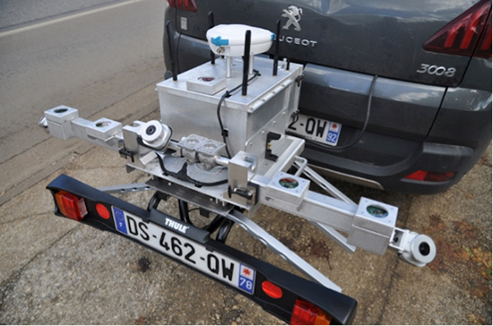
GetYourSpace platform: The white G-Nav smart antenna contains the Trimble MB-TWO GNSS module. (Photo: Trimble)
The French company Bouygues Energies & Services (BYes) provides solutions that help cities operate efficiently. The company recognized the need for a mobile, automated system to collect lighting data and produce results accessible by a variety of users.
The opportunity evolved into the BYes “GetYourSpace” service, which collects and analyzes lighting and other facets of urban environments. It uses a GIS-based approach to provide mapping and visualization functions.
BYes set out to develop a compact platform that could detect and measure sources and characteristics of light. To present information using GIS, the GetYourSpace platform needed to include reliable geolocation. BYes called on Cadden, a French developer of location systems for marine and industrial applications, to provide the positioning component for the GetYourSpace platform.
Reliable geolocation
MB-Two module by Trimble.
For the GetYourSpace collaboration, Cadden proposed a version of its G-Nav smart antenna, a product from Cadden’s GEOD brand. The G-Nav is built around a Trimble MB-TWO compact OEM GNSS module, an advanced GNSS receiver in a compact form designed for easy integration. The MB-TWO provides a range of GNSS configuration options, which allowed Cadden to produce a positioning system tailored to the BYes requirements.
The communications ability of the MB-TWO enabled Cadden to streamline the development process. The module provides multiple input/output options and can be configured and controlled using a web interface as well as a simple ASCII command set. Cadden leveraged the module’s small size and low power requirements to embed it into a compact, robust GNSS unit that combines power and data into a single connection.
High-speed data collection
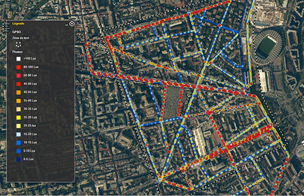
Heat map of lighting data collected by GetYourSpace. Accurate geolocation is essential to producing easy-to-use results. (Image: BYes, Trimble)
Cadden’s implementation of Trimble GNSS provided key enabling technology for GetYourSpace. With an area of 1 square meter, the mobile platform includes the GNSS, light and environmental sensors, system controller and data logging.
The MB-TWO rapid update rate (up to 50 Hz) enables the GetYourSpace platform to capture accurate information even while moving at high speed. The low-power, lightweight platform can be mounted on a small car or towed behind a bicycle and requires minimal interaction with the operator or driver.
After a couple of good hours of progress, we suddenly ran up against a massive “tail-back” — as the English call road-blocks — on the A303. We eventually crawled along further and discovered that all the rubber-neckers were slowing to grab a glimpse of Stonehenge, which you can see on the left, not far from the road. A little further on I saw a sign for Farnborough and thought that its surely around this time of year for that huge aerospace show known as the Farnborough International Airshow. So when I arrived home after almost three email-less weeks, it was not surprising that my inbox was crammed with lots of European aerospace news.
SkyGuardian MQ-9B
General Atomics (GA-ASI) seems to have come out tops in UAV public relations, flying its MQ-9B company-owned SkyGuardian from Grand Forks, North Dakota, to Royal Air Force (RAF) Fairford in Gloucestershire, U.K. on July 10-11 — that’s a 3,760 nautical mile flight in a fraction just over 24 hours. The RAF has operated the MQ-9 Reaper for over 10 years and the RAF configuration of the MQ-9B will apparently be called PROTECTOR RG Mk1. It just so happens that the RAF is celebrating its 100-year anniversary, so GA-ASI took the opportunity to drop in and say hello at a much smaller airshow at Fairford July 13-15.
Then they announced last week at Farnborough that GA-ASI had been selected to provide UAS to the Royal Netherlands Air Force (RNLAF) following consideration by the Ministry of Defence for the Netherlands. Doesn’t sound exactly like a contract yet, but its close enough to say that the Netherlands will take delivery of the Predator B/MQ-9 Reaper Medium Altitude, Long-endurance UAS. They also reminded us that the Spanish Air Force is to take delivery of MQ-9 systems in 2019.
From a SatNav point of view, we might also be interested that the GPS receiver on this UAV has also been upgraded to add Galileo signal capability — a requirement for what seems to be an expanding number of government forces in Europe. No luck yet in securing better information from GA-ASI about this upgrade, but Farnborough has likely kept them hopping, so hopefully more news later.
Zephyr S High Altitude Pseudo-Satellite UAV
Photo: Airbus
Fresh on the heels of taking on the Canadian Bombardier C-Series program (now the Airbus A-220) and closing the first deal with JetBlue for 60 of these aircraft, Airbus has committed to production of the Zephyr S HAPS (High Altitude Pseudo-Satellite) solar–electric, stratospheric UAV.
Zephyr has an 82-ft. wingspan and is designed to operate on solar power in the stratosphere at an altitude of around 13 miles emulating equivalent services provided by satellite. This is well above clouds, the jet stream and the ozone layer, and importantly well away above regular air traffic. Airbus anticipates the drone flying for up to 100 days without landing (its currently record is 14 days) and to travel up to 1,000 nautical miles per day. It weighs 165 pounds, but can support a payload up to five times its own weight.
The Zephyr aircraft began its maiden flight in Arizona a few days ago — the “qualification flight” is being supported by both the U.K. and U.S. governments — and the U.K. Ministry of Defence is the launch customer for Zephyr. The aircraft has so far logged around 1,000 hours total flight time. The test flight will conclude once engineering objectives have been met. Other solar-cell powered aircraft have struggled with landing or take off due to the large wing, light weight and hence stability under wind gusts, so several projects have not progressed past the R&D stage. Airbus & RAF’s commitment to production indicates their faith in the aircraft design.
Staying with the U.K. theme, the Goodwood Estate in Chichester, England — famous for the Goodwood car racing circuit — has recently hosted the Goodwood Festival of Speed, which apparently included drone racing. And at the same time, a Guinness World Record drone speed record was established.
Wingcopter XBR
The Wingcopter XBR is a tilt-rotor UAV with two lift props and two horizontal velocity props, and the drone flown by teenage drone racer Luke Bannister reached an average of 240.6kmph (~150m/h) over a Goodwood 100 meter track, flying over the measured track in both directions to account for wind. This set the world record for the fastest ground speed by a “remote-controlled tilt-rotor aircraft.” A previous record of 179.6 mph has been achieved by a quadcopter drone rather than a tilt-rotor UAV like the Wingcopter, but there is apparently more drag with type of drone, so its classified as a different category of UAV.
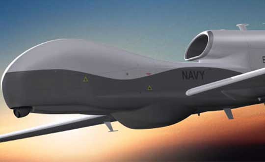
Northrop Grumman Triton High Altitude UAV
Northrop Grumman Triton High Altitude UAV. (Photo: Northrop Grumman)
Meanwhile, Northrop Grumman released a statement at Farnborough on their continuing discussions with Germany towards the sale of its high-altitude Triton MQ-4C unmanned surveillance drone, but apparently a lot of work still remains. In April the U.S. State Dept. authorized the sale of up to four drones worth up to $2.5 billion, and the German government has since been working closely with the US Navy towards a deal.
People may recall the previous cancellation of the “Eurohawk” program back in 2013 — under which Germany had planned to buy a version of Northrop’s Global Hawk drone — after escalating estimated costs for civil certification of the vehicle hit 600 million euros ($702 million) — not a minor task in any way.Subsequently, Northrop and Airbus Defense and Space have teamed up on a new ‘Pegasus’ program, which will add UAVs to Germany’s surveillance capabilities — drones flying autonomously as high as 60,000 feet to gather a wide array of intelligence data.
The German government plans to buy three of the drones, equipped with sensors and a mission system now to be engineered by Airbus. Preparations for certifying equipment to enable the drones to operate in civil airspace are moving more smoothly this time, but with deliveries to only start in 2025. Northrop developed the Triton, a marine-based variant of the Global Hawk, under a U.S. Navy contract awarded in 2008. And Australia last month said it plans to buy six Triton aircraft for maritime patrol, initially expected to cost A$1.4 billion ($1 billion U.S.).
So, lots of military drone stuff this month — not unusual given the nature of the Farnborough U.K. airshow, even though Boeing and Airbus also use the show to one-up each other’s announcements of commercial aircraft contracts and options. Lots of good news for General Atomics, not so much yet for Northrop Grumman, and some light relief with high speed drone records at Goodwood. Back to more North American UAV news hopefully next month.
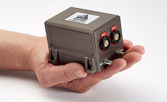
NovAtel is now delivering its SPAN tightly coupled GNSS+INS navigation technology in a rugged, ultra-compact unit.
Commercially exportable and designed for integration into a wide variety of applications, the high-performance SPAN CPT7 delivers assured positioning anywhere, in a package one-quarter the size of the company’s SPAN-CPT.
SPAN technology leverages generations of precise positioning expertise and advanced algorithms to tightly couple GNSS and inertial navigation system (INS) measurements. The system enables continuous, robust positioning and fast reacquisition in challenging navigation environments where GNSS signals may be unreliable or unavailable for short periods.
The new SPAN CPT7 also incorporates dual antennas to deliver instant alignment, along with interference detection and mitigation using NovAtel’s OEM7 Interference Toolkit (ITK) technology.
Integrators can take advantage of a spectrum analysis function of ITK to identify interference within the GNSS frequency bands and whether interference is coming from the external environment or due to other components in an integration project, NovAtel said. Mitigation features within ITK allow developers to implement digital filters and eliminate the problem.
Combining the multi-frequency, multi-constellation technology of the OEM7720 receiver board with ITK and the high-performing micro-electromechanical systems (MEMS) IMU, the SPAN CPT7 delivers anti-jamming functionality in an ultra-compact enclosure that fits in the palm of your hand. When paired with the GPS Anti-Jam Antenna (GAJT) in military applications, SPAN CPT7 is an integral part of assured position, navigation and timing (A-PNT).
“The remarkable new SPAN CPT7 delivers solutions for defense, mobile mapping, and autonomous vehicle applications with more flexibility than ever before,” said Neil Gerein, director, product management, NovAtel. “This new product saves customers space and weight without compromising accuracy or performance.”
STMicroelectronics has introduced the automotive-grade ASM330LHH six-axis inertial sensor for super-high-resolution motion tracking in advanced vehicle navigation and telematics applications.
Photo: STMicroelectronics
Serving demands for continuous, accurate vehicle location to support automated services, the ASM330LHH lets advanced dead-reckoning algorithms calculate precise position from sensor data if satellite signals are blocked, such as in urban canyons, tunnels, covered roadways, parking garages or dense forests.
Its advanced, low-noise, temperature-stable design enables dependable telematics services such as e-tolling, tele-diagnostics and e-Call assistance. Precision inertial data in six axes also meets the needs of advanced automated-driving systems, the company said.
Automotive component manufacturer Magneti Marelli has selected the ASM330LHH for advanced telematics systems, to be fitted as original equipment by global automotive groups in upcoming vehicle ranges.
For the ASM330LHH, as with all its MEMS sensors, STMicroelectronics owns the entire manufacturing process, from designing the sensors, through wafer fabrication, packaging, test, calibration and supply. Full end-to-end control enables STMicroelectronics to create high-performing sensors and assure customers of a robust and responsive supply chain, with rigorous end-of-line quality screening, the company said.
“STMicroelectronics is the largest supplier of MEMS sensors for automotive non-safety applications, such as navigation and telematics,” said Andrea Onetti, Analog, MEMS and Sensors Group vice president at STMicroelectronics. “Our latest-generation inertial sensor, the automotive-grade ASM330LHH, enables precise positioning for safer, smarter driving.”
Engineering samples will be available for evaluation by the third quarter of 2018, and volume production will begin the following quarter.
Further technical information on the ASM330LHH
Temperature range up 105 degrees Celsius giving designers extra freedom to locate electronic controls in hot areas such as in smart antennas on the vehicle roof, or near the engine compartment.
Ultra low noise allows greater measurement resolution by minimizing integration errors when positioning is reliant on sensors only.
High linearity and built-in temperature compensation eliminate any need for external compensation algorithms over its operating range.
Lowest power consumption in class, with features for optimizing power management if battery usage becomes crucial.
Qualified according to AEC-Q100 automotive-grade robustness standard.
Built on STMicroelectronics’ proven, proprietary ThELMA MEMS process technology, which enables integration of both the three-axis accelerometer and three-axis angular-rate sensor (gyroscope) on the same silicon for optimum yield, quality, and reliability.
The electronic interface integrates the signal chain for both sensors on a single die using STMicroelectronics’ 130nm HCMOS9A technology.
Reference designs, as well as STMicroelectronics’ Teseo satellite-positioning modules and related software are available. The dead-reckoning algorithm included with the Teseo III GNSS-receiver chipset already supports the ASM330LHH to generate a high-accuracy output suitable for autonomous navigation.
Tiny, low-profile 3mm x 2.5mm x 0.83mm device for minimal impact on the size of any on-board module.
Packaged as a leadless Land Grid Array (LGA) device.
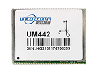
The UM442 can simultaneously track GPS, BDS, GLONASS and Galileo. It also supports SBAS and QZSS. It uses Uncore’s new-generation Nebulas II chip and UGypsophila real-time kinematic (RTK) algorithm. Based on high-performance data-sharing technology and the simplified operation system of the Nebulas II chip, the UGypsophila RTK algorithm dramatically optimizes matrix processing, enabling the UM442 to track more satellites and shorten the initialization time to 5 seconds.
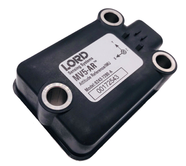
The MV5-AR inertial sensors are designed for off-highway and military vehicles, marine and mobile robot applications, and the autonomous vehicle market. The rugged, compact sensors use LORD’s fifth-generation high-performance industrial-grade solid-state six-degrees-of-freedom (6-DOF) micro-electromechanical accelerometer and gyro inertial sensor technology. Successfully deployed on ground robots and heavy machinery, applications also include autosteer and terrain compensation; dynamic incline detection (roll, pitch, rotation); vehicle stability and leveling; platform control, alignment and stabilization; operator feedback; and precision navigation. The compact and rugged reinforced housing is fully sealed for immersion and pressure wash. Each sensor is calibrated and temperature compensated.
BeiDou Phase 3 signals are now available on Spirent GNSS RF constellation simulators GSS7000 and GSS9000 — existing users can obtain the software upgrade by contacting Spirent. Phase 3 of the Chinese BeiDou system will extend its coverage from Asia to the entire world, providing receiver developers and integrators with additional GNSS signals to make positioning, navigation and timing systems more accurate, and help to support new applications, such as autonomous vehicles. Customers can test their designs before the system is fully operational in 2020.
The ZED-F9P multi-band GNSS module has integrated multi-band real-time kinematic (RTK) technology for machine control, ground robotic vehicles and high-precision unmanned aerial vehicles applications. It measures 22 x 17 x 2.4 millimeters and uses technology from the u‑blox F9 platform to deliver robust high-precision positioning performance in seconds. The ZED-F9P is a mass-market multi-band receiver that concurrently uses GNSS signals from all four GNSS constellations (GPS, GLONASS, Galileo and BeiDou). Combining GNSS signals from multiple frequency bands (L1/L2/L5) and RTK technology lets the ZED‑F9P achieve centimeter-level accuracy in seconds.
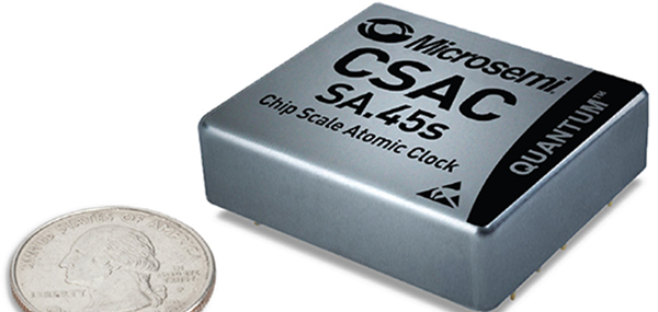
The SA.45s Commercial Space Chip-Scale Atomic Clock (CSAC) is a commercially available radiation-tolerant CSAC suitable for low Earth orbit (LEO) applications. The device provides the accuracy and stability of atomic clock technology while achieving significant breakthroughs in reduced size, weight and power consumption. It provides excellent drift performance and built-in 1 pulse per second (PPS) input for GPS disciplining, making the device well-suited for holdover applications. Commercial and research space applications include satellite timing and frequency control; satellite cross linking; assured position, navigation and timing; and Earth observation.
The long-range, power-efficient eRadio is designed to support high-precision GNSS real-time kinematic (RTK) applications in surveying and precision agriculture. It is enabled with intelligent serial baud rate identification for different RTK devices. It can automatically identify RTK serial baud rate with a radio data cable and provide a plug-and-play form for easy connection between the eRadio and RTK. With its high transmitting power (5-35 Watts), transmission data can be up to 19200 bps/s over a connection distance of 50–80 kilometers. It can work as either a base or repeater with other Harxon radio modems in challenging environments.
Wireless communication with any Android or Windows terminal
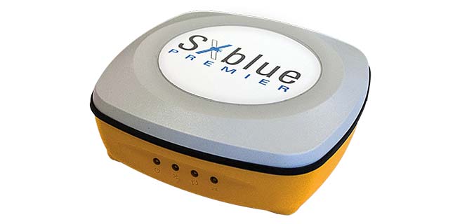
Image: SXblue/Geneq
The SXblue Premier GNSS receiver is available in a submetric version (GNSS) or centimetric version (RTK). It is equipped with Pacific Crest Maxwell 6 Trimble technology with BD910 (GNSS version) and BD930 (RTK version) OEM boards, delivering 220 channels to acquire and track GNSS signals from all constellations in view. It makes effective use of GPS, GLONASS, Galileo, BeiDou, QZSS and SBAS signals for precise positioning.
The single-frequency, multi-GNSS Vector V123 and V133 all-in-one smart antennas are multi-GNSS compass systems using GPS, GLONASS, BeiDou, Galileo and QZSS for simultaneous tracking for heading, position, heave, pitch and roll. Both support NMEA 0183 and NMEA 2000. The V123 and V133 thrive in radar/ARPA, AIS, ECDIS, side-scan survey, multi- and single-beam surveys, dredging and general navigation applications.
The Trak4 provides GPS tracking with cell-trilateration fallback. Ping rates can be selected from every two minutes to once a day, with email and text alerts provided for geozone entry and exit or if the high-capacity rechargable battery is low (the battery runs up to 12 months on a single charge.) The Trak4 is designed for tracking vehicles, assets and inventory; it can also be used to track people such as the elderly. Indoor/outdoor weatherproofing allows “anywhere” mounting.
PCTEL’s multi-GNSS L1/L2/L5 antennas combine aerospace-level precision with global satellite compatibility in a highly durable package. They enable critical applications including vehicular automation, 5G network timing synchronization and Positive Train Control (PTC) systems. The antennas increase the accuracy of timing and location information by providing simultaneous access to multiple GNSS signals across multiple frequency bands. The antennas support all relevant GPS, GLONASS, BeiDou and Galileo frequencies with excellent multipath mitigation and high out-of-band rejection for greater signal clarity. Their robust AAR and IP67-compliant design makes them suitable for years of use on railways and in other harsh real-world environments.
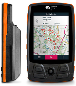
Four new GPS handhelds are designed for off-road use, with safety in mind. All four of the OS GPS models have a built-in SIM card with access to the SeeMe subscription-based service and its safety features. With I.C.E (In Case of Emergency), users can send emergency alerts with exact coordinates to family and friends directly from the OS GPS. Live Tracking enables the user to be locatable at all times, sharing location and performance data with up to 20 friends in real time. Aventura, the most advanced navigation device, can be used in all weather conditions.
Zubie Fleet Connect provides real-time GPS fleet tracking, driver check-in and performance reports, and vehicle health alerts. The monitoring and reporting service lets managers of fleets from 2 to 5,000 vehicles optimize business on the road. Wi-Fi connection to the cloud delivers important information about the health and performance of the vehicle, enhancing driver safety. Zubie also works with large enterprises to develop custom data flows and access driving data that can be used to analyze driving patterns, spot geographical trends in activity, or improve fleet asset management based on vehicle wear and tear.
The Heliscope 2.0 provides onboard data collection with speed, efficiency and productivity improvements for the utility inspection industry. It provides a solution for operations over greater distances or in harsher environments than drones can accommodate The system integrates multiple sensor systems into a single, lightweight helicopter payload, capable of simultaneously collecting a range of data types required for utility maintenance and vegetation management inspections. Deployment enables optimized inspection and maintenance schedules, offering potential cost savings in those operational activities by as much as 50 percent. The Heliscope 2.0 has flexible mounting configurations and the ability to adapt for mounting on many different helicopter types.
Based on DJI’s M600 Pro platform, the Leica Aibot system is designed to rapidly and autonomously enable digitizing of critical infrastructure. It enables users to get a complete data set quickly with a user-friendly interface. Using Leica Infinity for point-cloud, digital surface model and orthophoto generation enables surveyors to process and visualize aerial data. For construction projects, Aibot provides access to critical information to perform volume calculations and monitor site progress. Users can see high-definition imagery and 3D mapping of the site and document progress. The UAV data can be combined with other survey technologies such as GPS for a more complete set of information.
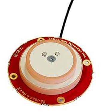
Two lightweight, compact antennas are designed for UAVs with a low aerodynamic profile. Antenna model TW1829 is for original equipment manufacturers (OEMs), and model TW8829 is a housed version. Accutenna technology provides high-level rejection of multipath signals, a phase linear response and tight phase-center variations. Pre-filters prevent saturation of the front-end low noise amplifier by strong near frequency and harmonic signals.
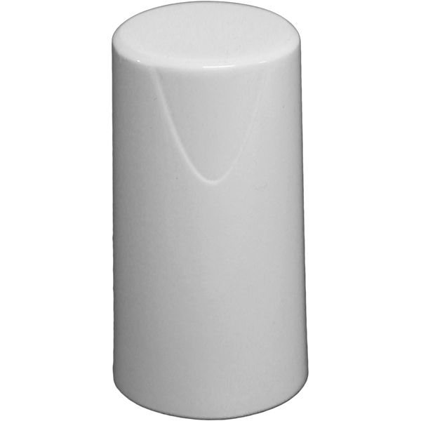
The HA32 high-performance antenna supports GPS, GLONASS, Galileo, BeiDou and Hemisphere’s Atlas L-band correction service. It is designed for UAVs, geographic information systems (GIS), surveying, real-time kinematic (RTK) and other applications requiring high-precision positioning and navigation. The HA32 is built on a proprietary four-helix antenna technology that provides superior filtering and anti-jamming performance with features such as a low noise figure of 2.0 dB (typical) and up to 30-dB gain (typical). Suitable for most outdoor and harsh operating environments, the HA32 antenna is sealed in a durable and ruggedized IP67-rated. The lightweight (40 g, typical), compact form factor (40 x 75 mm) makes it resistant to wind when on UAVs.