Tag: OEM

  • Launchpad: Simulate signals from GNS, regional navigation

    Launchpad: Simulate signals from GNS, regional navigation

    Constellation Simulator

    Simulate signals from all GNSS and regional navigation

    Spirent's GSS9000 constellation simulator.
    Spirent’s GSS9000 constellation simulator.

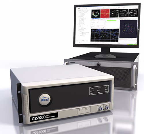
    The Spirent GSS9000 Multi-Frequency, Multi-GNSS RF Constellation Simulator can simulate signals from all GNSS and regional navigation. It offers a four-fold increase in RF signal iteration rate (SIR) over Spirent’s GSS8000 simulator.

    The GSS9000 SIR is 1000 Hz (1 ms), enabling higher dynamic simulations with more accuracy and fidelity. It includes support for restricted and classified signals from the GPS and Galileo systems, as well as advanced capabilities for ultra-high dynamics. It can evaluate resilience of navigation systems to interference and spoofing attacks, and has the flexibility to reconfigure constellations, channels, and frequencies between test runs or test cases.

    Hardware changes can be made in the field, supported by the new on-board calibrator module. The GSS9000 is extensible and can support the widest range of carriers, ranging codes, and data streams for the Galileo, GPS, GLONASS and BeiDou systems, as well as regional/augmentation systems. Multi-antenna/multi-vehicle simulation for differential-GNSS and attitude determination, and interference/jamming and spoofing testing are also supported.

    GSS9000 Attributes

    • 1000-Hz simulation iteration rate (SIR) and hardware update rate (HUR) enabling real-time remote control and trajectory delivery with extremely low latency and simulation of ultra-high dynamic motion
    • 160 channels plus 640 embedded multipath channels across 10 independent frequencies in one chassis
    • Single RF version and dual RF version for differential GNSS and multi-vehicle simulation
    • 0.3 mm RMS pseudorange accuracy, 120,000 m/s relative velocity
    • Highly flexible configurations selectable via a “cabinet” of license keys
    • Complete portability of Spirent SimGEN scenarios
    • In-field upgradeability
    • Future-proofed for all advances in GNSS technology

    Spirent Federalwww.spirentfederal.com


  • Launchpad: Positioning engine incorporates TerraStar correction data

    Launchpad: Positioning engine incorporates TerraStar correction data

    NovAtel CORRECT with PPP
    NovAtel CORRECT with PPP.

    NovAtel CORRECT is the core positioning engine on NovAtel GNSS receivers, incorporating corrections from a variety of sources to provide the position solution suitable for a variety of applications.

    NovAtel CORRECT with PPP utilizes correction data from TerraStar. GNSS satellite clock and orbit correction data from the TerraStar network is delivered directly to the NovAtel receiver where it is combined with NovAtel CORRECT algorithms to offer two levels of positioning accuracy: TerraStar-C for 5-centimeter-level positioning with instant reconvergence after short GNSS outages, and TerraStar-L with horizontal position accuracy of 50 centimeters.

    The TerraStar network provides continuous satellite coverage worldwide, with 80 GNSS reference stations located around the globe. Three widely distributed Network Control Centers deliver data over seven independent satellite beams. This fully redundant system means TerraStar offers an extremely robust, reliable correction service users can rely on 24/7.

    Benefits of Novatel CORRECT with PPP

    • Elimination of base station and communications equipment, simplifying equipment needs
    • Same performance anywhere on Earth
    • Robust performance in variable conditions
    • Corrections delivered direct to the end user

    NovAtel, novatel.com/terrastar

  • Microsemi announces thermally improved chip-scale atomic clocks

    Microsemi announces thermally improved chip-scale atomic clocks

    Microsemi Corporation has announced its new thermally improved chip-scale atomic clock (CSAC) components with full operating and storage temperature. The new devices offer low-power holdover atomic clock technology without compromising size, weight and power (SWaP) while operating at a wide temperature range.

    Microsemi is exhibiting this week at ION GNSS+, being held in Portland, Oregon.

    chip-scale-atomic-clock-csac-wWith an operating temperature range of -10 to 70 degrees Celsius, Microsemi’s new CSAC components are highly reliable, with improved product design, process enhancements and robust product verification/validation, the company said.

    The revolutionary technology enables new applications and missions not possible in the past with traditional OCXO and Rubidium clocks, offering the low SWaP clock technology at 17 cubic centimeters (cc) in size, 35 grams of weight and only 120 milliwatts of power. Microsemi’s CSAC product offers ±5.0E-11 accuracy at shipment and a typical ≤ 9.0E-10/month aging rate, which makes it suitable for many low-power atomic clock holdover applications.

    “The enhancements to our CSAC product offering focus on providing the highest reliability without compromising performance for our customers, particularly in mission critical applications where every milliwatt matters,” said Ramki Ramakrishnan, director of product line management, at Microsemi. “These devices utilize an innovative approach to the component level atomic clock that will help Microsemi access the entire oscillator industry, along with miniature atomic clocks (MAC), and capitalize on the revenue growth potential within the defense, communications, industrial and test and measurement markets.”

    According to the “Crystal Oscillator Market—Global Forecast & Analysts” report posted by Markets & Markets, the total available market (TAM) for the overall oscillator market is estimated to be $2.4 billion in 2016, with OCXO markets targeted by CSAC estimated to have a serviceable addressable market (SAM) of $260 million in 2016.

    Microsemi’s thermally improved CSAC products support the company’s strategic presence in the defense and security markets, targeting applications such as low-power holdover against GPS vulnerabilities for position, navigation and timing security. They are also suitable for holdover in underwater (ocean bottom nodal) applications and atomic frequency reference in test and measurement applications.

    “Leveraging the unique attributes of Microsemi’s CSAC technology, our company is able to offer an unprecedented combination of holdover, g-sensitivity, low power consumption and warm-up performance, while reducing the footprint to less than the critical 0.6 inches height — allowing retrofitting of legacy equipment,” explained Said Jackson, president of Jackson Labs Technologies, Inc. “The CSAC combined with our battle- and theater-proven software algorithms and support hardware enables vastly extended mission times while providing critical backup performance for GPS-denied environments when even the optional integrated Selective Availability Anti-spoofing Module (SAASM) GPS technology is jammed.”

    Microsemi’s thermally remediated CSAC components are sampling now, with full production in October. For more information, visit the website or contact [email protected].

  • Xsens launches knowledge BASE for inertial tracking, wearable motion capture

    Xsens launches knowledge BASE for inertial tracking, wearable motion capture

    xsens-base-w

    Xsens has launched BASE, an online technology platform with a community forum and a knowledge base on 3D motion tracking technology and products.

    On BASE.xsens.com, the knowledge base contains inside information about micro-electro-mechanical system (MEMS) sensors, inertial measurement units (IMU), sensor fusion algorithms, body-motion tracking and motion capture.

    It also provides best practices, tips and tricks for the use of Xsens’ successful products the MTi series, the MTw and the MVN wearable motion capture solutions. A second section of BASE is the community forum with direct access to Xsens’ engineers and other Xsens users.

    The knowledge base and community forum make it easier to integrate the MTi or MTw and to get the most out of MVN. If a question is not answered in the knowledge base, it is straightforward to ask a question to the community. With short response times from either other Xsens users or the entire Xsens engineering team, the user community is a quick way to continue development, Xsens said.

    BASE is a next step by Xsens to support the growing community and interest in inertial technology. It further enhances the interaction between users and Xsens.

    “Although Xsens makes it easy to use inertial technology in their applications, the underlying technology is complex and there are many features for specific applications,” said Remco Sikkema, Xsens marketing manager. “Understanding the technology makes it easier to integrate the products and be successful with Xsens.”

    With BASE, engineers and engineering teams in the Xsens community can come closer together. The primary goal is to make Xsens customers more successful by providing a platform to exchange information.

    There is no need to register for BASE to access the community forum and the knowledge base. To ask questions or comment on articles, registration is possible via SSO or email.

  • Rx Networks adds SBAS and QZSS for test and development

    Rx Networks Inc., a mobile location technology and services company, announced test and development access to upcoming SBAS and QZSS services at ION GNSS+, where the company is exhibiting.

    ION GNSS+ is being held in Portland, Oregon, Sept. 12-16.

    The addition of QZSS and SBAS to its location.io service platform enables Rx Networks to provide regional correction data and additional satellites for improved positioning accuracy.

    The location.io real-time GNSS assistance service includes a new streaming delivery method so customers can easily access SBAS correction data (available for testing). QZSS and SBAS support will be added to location.io’s Real-Time GNSS ephemeris HTTP interface in Q4 of 2016.

    Location service providers, GNSS chipset vendors and device OEMs can benefit from the additional corrections and assistance data for better accuracy and higher availability of GNSS location fixes.

    “The addition of SBAS and QZSS to location.io marks an exciting step as we expand our services to support high accuracy solutions,” commented John Carley, Director of Product Management, location.io.

  • Launchpad: GNSS simulator developed with JAXA

    The Replicator by IP Solutions  is a multi-frequency, multi-system GNSS simulator for advanced research and development, equipment testing and education. It can also function as a recording, playback and signal analysis instrument.

    IP Solutions is exhibiting this week at ION GNSS+, in Portland, Oregon.

    The Replicator is the result of a collaboration with the Japan Aerospace Exploration Agency (JAXA).

    mfr3-ipsolutions-replicator-wComponents include the Simceiver hardware device, the ReGen control software for real-time simulation, Streamer control software for recording and playback, and ARAMIS software receiver for signal analysis.

    The 24-channel Replicator provides real-time generation of GNSS signals, recording and playback of dual-frequency GNSS RF signals, and GNSS RF signal analysis with JAXA COSMODE ionospheric scintillation monitor.

    The Replicator offers real-time simulation of dual-frequency GPS, GLONASS, BeiDou or GPS+GLONASS, GPS+BeiDou, GPS+Galileo signals.

    Comprehensive simulation models include atmosphere, multipath, and more. Also available is signal analysis based on JAXA COSMODE ionospheric scintillation monitor.

    Two or more units can be used to simulate, record and playback more signals at the same time. Simulated and recorded signals can be stored in digitized format, analyzed by a MATLAB software receiver and played back as RF at any time.

    Replicator Advantages

    • User defined models with ANSI C API
    • Real-time simulation
    • Record and playback
    • GNSS signal analysis
    • Upgradable to more features , signals and frequencies for the difference in price.

    IP-Solutions, www.ip-solutions.jp

  • Racelogic launches wideband system at ION GNSS+

    Racelogic launches wideband system at ION GNSS+

    LabSat 3 by Racelogic is a lightweight and portable system for GNSS testing, capable of recording and replaying the raw radio signals including GPS L1, GLONASS L1, Galileo E1, BeiDou B1, QZSS and SBAS. LabSat 3 records real-world data, reproducing all GNSS artefacts on the laboratory bench, including multipath, ionospheric effects and signal dropouts. There is no limit to the number of satellites that can be logged.

    The ION GNSS+ 2016 Exhibition will include the launch of the new LabSat 3 Wideband system, which offers significantly higher bandwidth and enhanced frequency range. With three RF channels and up to 50 MHz bandwidth per channel, LabSat 3 Wideband will record and replay most current GNSS signals including GPS L1, L2 and L5, all in one file.

    labsat-real-time-wFeatures include RF data recording up to 3-bit quantization together with bandwidth up to 50 MHz. A removable battery pack offers more than two hours of record time. All of the fetures come in a compact, lightweight package weighing under 1.2 kilograms.

    One-touch control, data capture to removable media, dual CAN, RS232 and Digital I/O record and replay capability ensures that the LabSat 3 range is a convenient system for any developer who requires realistic testing at a competitive price.

    Also available is SatGen, the simulation software that allows for the creation of user-generated scenarios to be replayed through the LabSat. SatGen has recently been upgraded so that not only can it provide GPS, GLONASS and BeiDou signals, it now includes a real-time capability. This allows for GNSS RF signals to be created with a current time stamp. SatGen is a powerful tool for those wishing to test new GNSS devices with any dynamics, location or time.

  • Septentrio to supply GNSS reference stations, timing receivers to JPL

    Septentrio to supply GNSS reference stations, timing receivers to JPL

    Septentrio has received a contract to supply 35 high-precision GNSS receivers to the Jet Propulsion Laboratory (JPL) for use in the NASA Global GNSS network (GGN).

    The NASA GGN is one of the world’s largest global GNSS tracking networks with nearly a hundred reference receivers deployed worldwide and is a participant in the International GNSS Service (IGS). The GGN is also the core tracking network of JPL’s Global Differential GPS (GDGPS) System, a highly available and reliable service providing mission-critical position, navigation and timing data, as well as environmental monitoring for industry and government operations.

    The Septentrio PolaRx5 GNSS receiver.
    The Septentrio PolaRx5 GNSS receiver.

    Under the contract, Septentrio will supply 35 of its new-generation PolaRx5 GNSS receivers, including 25 reference stations and 10 timing instruments. Deliveries began in August and will be completed in September.

    The PolaRx5 incorporates Septentrio’s most advanced multi-frequency GNSS engine, which tracks all major satellite signals including GPS, GLONASS, Galileo and BeiDou, as well as the regional QZSS and IRNSS satellite systems. It provides measurement quality and interference mitigation, and operates on less than two Watts when receiving GPS and GLONASS satellite signals.

    “This major contract with JPL — a widely recognized industry leader in GPS and GNSS technology — is an important validation of Septentrio’s position as the number one preferred supplier of highly accurate GNSS receivers for scientific applications, and recognition of the superior performance of our next-generation GNSS receivers,” said Neil Vancans, vice president of Septentrio Americas.

  • Launchpad: Dynamic testing before flight

    Launchpad: Dynamic testing before flight

    GNSS/INS Integration Testing

    Dynamic testing before flight

    The CAST-3000 simulator from CAST Navigation.
    The CAST-3000 simulator from CAST Navigation.

    The CAST-3000 fully supports integration testing of GNSS/INS navigation systems where the inertial sensor and GNSS receiver are either tightly or ultra-tightly coupled. It produces GPS RF signals coincident with simulated IMU sensor data that provide dynamic testing in the laboratory environment for military and government applications.

    The proprietary laboratory test interfaces to inertial navigation products of both Honeywell and Northrop Grumman are incorporated with high-performance fighter aircraft and munition dynamics. The CAST-3000 simulates dynamics for both the GNSS and INS portions of EGI (embedded GNSS-inertial navigation) systems in a coordinated and coherent way so that the GNSS and INS navigation solutions do not diverge, and the blended solution is precisely what it would be in the real world. This is accomplished by simulating both the GNSS and INS inputs.

    The military and government labs that the CAST-3000 supports have strict requirements for dynamic ground testing of navigation systems before flight testing. The simulator must explore performance of both GNSS and INS aspects of the EGI for modeling IMU drift rates in GPS jamming environments.

    CAST-3000 Features

    • Strapdown IMU measurement data synchronized with GPS RF data provided to the navigation system under test.
    • Mature avionic sensor simulation barometric altimeter model.
    • High-rate inertial measurements with very high degree of fidelity to support testing of high performance coupled systems.
    • Simulates sensors to provide the fully coordinated, dynamic vertical channel aiding needed to maintain Kalman filter stability of the navigation system. Includes years of development and refinement of the precise GNSS/INS synchronization capability needed for simulation of aircraft dynamics.
    • A dynamic, precisely coordinated simulation of numerous navigation signals to a tightly coupled or ultra-tightly coupled GNSS/INS navigation system.

    CAST Navigation, www.castnav.com

  • NovAtel introduces OEM7 with next-gen positioning technology

    NovAtel introduces OEM7 with next-gen positioning technology

    NovAtel launched its new OEM7 family at ION GNSS+ 2016, which is being held Sept. 12-16 in Portland, Oregon. OEM7 expands the receiver options open to system integrators.

    Five GNSS receiver cards are available, including the new OEM7600, the smallest, lightest dual-frequency receiver card ever developed by the company.

    All cards have 555 available channels, are multi-constellation and multi-frequency and provide new advanced interference awareness and mitigation capabilities. Additionally, every OEM7 card can receive satellite-based TerraStar correction signals, making centimeter-level positioning globally available even in difficult operating environments. A new compact enclosure, the PwrPak7 houses OEM7 receiver technology, plus offers 16-GB of onboard data storage, built-in Wi-Fi and serial, USB, CAN and Ethernet for ease of integration.

    A cornerstone of the OEM7 platform is the Interference Toolkit. The Interference Toolkit is used to detect sources of interference and intentional and unintentional jamming, and then mitigates such occurrences using proprietary NovAtel filters. Integrators can take advantage of a spectrum analysis function that identifies which GNSS frequency is experiencing the interference. Further, it can also detect electromagnetic interference caused by other components in an integration project, allowing developers to implement the filter and eliminate the problem.

    NovAtel’s SPAN GNSS + Inertial technology delivers continuous 3D position, velocity and attitude (roll, pitch, yaw), and now is available on every OEM7 receiver.

    OEM 7 Features

    • Multi-constellation and multi-frequency with 555 channels.
    • Advanced interference awareness and mitigation with an Interference Toolkit for integrators.
    • TerraStar corrections for centimeter positioning.
    • SPAN GNSS + Inertial technology.
    • PwrPak 7 enclosure with 16-GB of onboard storage.
    • Built-in Wi-Fi, plus serial, USB, CAN and Ethernet.
  • IFEN launches cost-effective NCS TITAN GNSS simulator

    IFEN launches cost-effective NCS TITAN GNSS simulator

    IFEN GmbH has launched its new NCS Titan GNSS simulator. The NCS Titan has up to 256 channels (and 1024 multipath channels) and up to 4 RF outputs per chassis, providing flexibility and outstanding performance, according to IFEN.

    The extra complexity and cost of using multiple signal generators is avoided, improving reliability without compromising on functionality, IFEN said in a news release.

    The innovative design of the NCS Titan allows users configure channels for any GNSS signals and allocate those channels to any of the RF outputs fitted. This flexibility enables the same simulator hardware to be used for an extensive range of tests, for all types of GNSS applications.

    The NCS Titan GNSS simulator by IFEN.
    The NCS Titan GNSS simulator by IFEN.

    The NCS Titan sets new standards in the field of GNSS Simulation, in terms of fidelity, accuracy, dynamics, iteration rates and reliability, the company said.

    “The launch of our brand new NCS Titan GNSS Simulator represents another milestone for our NCS GNSS simulator products,” explained Günter Heinrichs, head of customer applications. “This shows clearly once again our commitment to ongoing product enhancement and dedication to providing our customers with best GNSS test equipment on the market.”

    The NCS TITAN GNSS Simulator has been developed in cooperation with WORK Microwave GmbH, Germany.

  • Spirent GSS200D automates monitoring and analysis of RF interference

    Spirent GSS200D automates monitoring and analysis of RF interference

    Spirent's new GSS200D Interference Detection and Analysis solution.
    Spirent’s new GSS200D Interference Detection and Analysis solution.

    Spirent Communications has rolled out its new GSS200D Interference Detection and Analysis solution. The GSS200D was developed as part of Spirent’s partnership with Nottingham Scientific Limited.

    The GSS200D comprises field-based hardware and a secure data server for automatic capture and analysis of GNSS radio-frequency interference. Deployments of GSS200D probes readily provide users with a thorough understanding of the RF interference environment at sites of interest.


    Spirent will demonstrate the GSS200D at its booth during ION GNSS+ 2016, held Sept. 14-16 in Portland, Oregon.


    Spirent has already detected thousands of disruptive GPS L1 interference events with its global network of GSS100D detectors. By adding support of additional frequencies and constellations, as well as improving the analysis and reporting, the GSS200D responds to the demand of critical infrastructure and civil aviation customers.

    v1-02-capture-detail-2-w

    “The GSS200D is the first automated solution to identify and securely store multi-constellation GNSS RF interference. The GSS200D data server tools enable trend analysis and event identification over time, as well as re-generation of real world events,” said Romain Zimmermann, product manager at Spirent. “Our solution offers unique value because it enables informed decision making in areas such as site selection and approaches to make devices and systems more robust in the face of increasing threats that simply cannot be eliminated. It’s a truly end-to-end test solution which provides access to detected events through to the ability to regenerate and analyze results with real hardware.”

    The GSS200D is a detection system that operates simultaneously on GPS, GLONASS and Galileo in the L1 band. This functionality enables a wide range of users, such as critical infrastructure communications, broadcast and power distribution, civil aviation, road user charging and autonomous vehicles to detect, characterize and classify RFI sources that may affect their services.

    v1-01-analytics-priority-1-wCaptures of RFI events are logged and stored on PT Cloud, Spirent’s secure cloud infrastructure, allowing the end user confidential access to the results via a web portal. Advanced analytics and reporting features include visualization of both spectrogram and spectrum, as well as characterization of the type and priority of interferences, enabling monitoring over time and in-depth trend analysis. On-premise server options are also available.

    For more information, visit http://www.spirent.com/Solutions/Robust-PNT.