In separate letters to members of the House of Representatives and the Senate, seven companies and a non-profit urged Congress to support alternative positioning, navigation and timing systems (PNT) with the “necessary funds and other appropriate policy tools.”
The letters focus on and endorse the system-of-systems approach outlined in the Department of Transportation’s (DOT) recent report to Congress on the results of its GPS Backup Technology Demonstration. The report found an adequate and robust American PNT system should include space-based L-band signals, low-frequency (LF) and ultra-high-frequency (UHS) signals, and fiber connections between the terrestrial LF and UHF transmitters.
“Our country depends on GPS for critical infrastructure, and there is an urgent need for resiliency being built into our critical infrastructure. Before the report came out, some of us had different ideas of how the U.S. should go forward,” said Ganesh Pattabiraman, CEO of NextNav. “But the DOT report provided the data to make it very clear that it is a combination of technologies that need to come together to truly enable nationwide backup to GPS, and it was good to see we could get industry alignment on the findings.”
The letters describe many of the threats to GPS, both natural and malicious; its vulnerabilities; and the dire consequences of disruptions. They go on to state that robust, more reliable PNT is needed for emerging and future systems like E911, 5G, resilient electrical grids, drones and other automated systems.
Monty Johnson, CEO of OPNT, a provider of time-over-fiber services, praised the findings of the DOT report. “The key to resilience and reliability in a system-of-systems is including technologies that deliver the same information using starkly different means. It is hard to imagine a combination of technologies that are more diverse than fiber, satellites, LF and UHF.”
According to Pattabiraman, the signers of the letter agree that the DOT report made clear that there are mature technologies available today that can address the GPS backup issue. DOT and Congress now have the data to act to enable a much-needed resilient infrastructure for the country.
Dana A. Goward, president of the non-profit RNT Foundation, agreed. He also observed that deciding on the technologies and congressional funding were important, but only first steps. “The goal of this effort is not to just implement systems,” he said. “it’s to make America safer. Establishing the services quickly and efficiently will be key, as will ensuring they are widely adopted.”
“Protecting the nation from the consequences of a space-based PNT disruption will require that these systems be accessed and used by a wide variety of users from first responders and delivery services, to all forms of critical infrastructure,” Goward said. “This means the government will need to eliminate as many barriers to adoption as possible. One or more of these alternatives has to be available to every American. And a basic level of service has to be free, just like the GPS utility it is reinforcing. Fortunately, we estimate this can be done relatively inexpensively. It will be only a small fraction of the $1.7B we spent on GPS last year.”
The alternative to making this relatively modest investment, according to Goward, is unacceptable.
“There are lots of threats to GPS,” he said. “Take the sun for example. The most recent study I saw estimates a 70% chance solar activity will damage the GPS constellation in the next 30 years and a 20% chance it will destroy a big part of it. And the sun is just one of the threats we face. We can’t keep playing this kind of Russian Roulette with the fate of our nation. Especially when other countries like Russia and China have already taken steps to protect themselves with terrestrial systems.”
A copy of the letter sent to Senators can be found here, and the one to members of the House of Representatives here.
In our 10th annual Simulator Buyers Guide, we feature simulator tools, devices and software from 10 prominent companies that aid GNSS receiver manufacturers in product design.
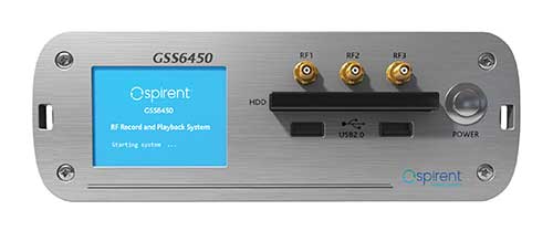
The GSS6450 RF record and playback system. (Photo: Spirent)
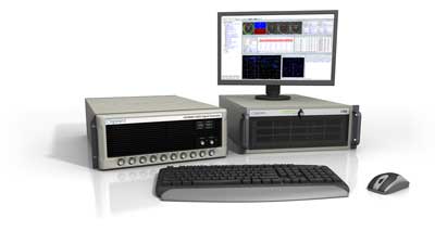
GSS9000, SimMNSA, CRPA test system, anechoic chamber testing, mid-range testing
Spirent Federal Systems provides PNT/GNSS test equipment that covers all applications, including research and development, integration/ verification, and production testing.
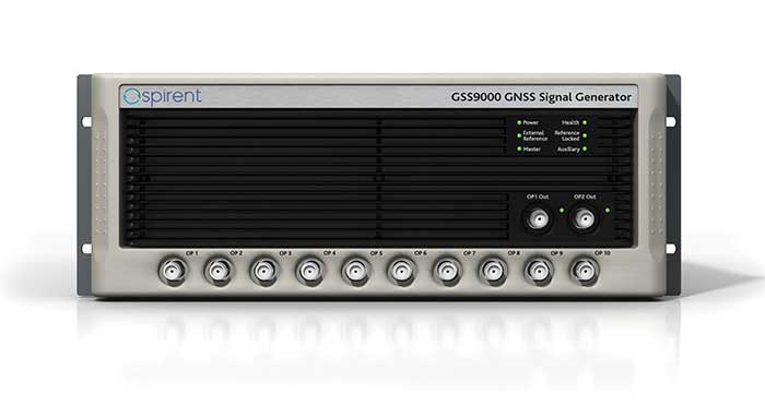
GSS9000. The GSS9000 Series Multi-Frequency, Multi-GNSS RF Constellation Simulator is Spirent’s most comprehensive simulation solution. It can simulate signals from all GNSS and regional navigation systems and has a recently-enhanced system iteration rate (SIR) of 2 kHz (0.5 ms), enabling higher dynamic simulations with more accuracy and fidelity. The GSS9000 supports restricted/classified signals, Alt RF, and other non-GNSS sensors. Users can evaluate the resilience of navigation systems to interference and spoofing attacks, and have the flexibility to reconfigure constellations, channels, and frequencies between test runs or test cases.
The GSS9000 Constellation Simulator. (Photo: Spirent)
SimMNSA. Spirent Federal has the first fully-approved MNSA M-code simulator. Authorized users of the GSS9000 series of simulators will be able to utilize the advanced capabilities of SimMNSA to create more robust solutions for their customers. SimMNSA has been granted security approval by the Global Positioning System Directorate.
CRPA Test System. Spirent’s Controlled Reception Pattern Antenna (CRPA) Test System generates both GNSS and interference signals. Users can control multiple antenna elements. Null-steering and space/ time adaptive CRPA testing are both supported by this comprehensive approach.
Anechoic Chamber Testing. Spirent’s GSS9790 Multi-Output, Multi-GNSS RF Constellation Wave-Front Simulator System is a development of the GSS9000. The GSS9790 provides the core element for GNSS applications that require a test system that can be used in both conducted (lab) and radiated (chamber) conditions.
Mid-Range Solutions. Spirent also offers solutions that cater to intermediate GPS/GNSS testing needs. The GSS7000 multi-constellation simulator provides an easy-to-use solution for GNSS testing that can grow with users’ requirements. The GSS6450 RF record and playback system enables repeated replay of a real-world GNSS/GPS test in the lab.
CAST-CRPA. The CAST-CRPA Simulation System produces a coherent wavefront of GPS RF signals to provide repeatable testing in the laboratory environment or anechoic chamber. The CAST CRPA system is configurable for any number of coherent outputs that users want.
With an intercard carrier-phase error of less than 1 millimeter, the CAST-CRPA Simulation System is extremely accurate.
The system generates a wavefront of GPS signals when its GPS RF generator cards are operated in a ganged configuration. Each generator card provides a set of GPS satellites coherent with the overall configuration. Several RF generator cards may be utilized together, ensuring phase coherence among the signal generator cards in each bank. The CRPA antenna, the antenna electronics and the GPS receiver can be tested as a unit with or without radiating signals.
CAST-CRPA features
Generates single coherent wavefront of GPS signals
Orolia advanced GNSS simulators offer a wide breadth and depth of simulation tools to test mission-critical positioning, navigation and timing (PNT) applications and scenarios. They are feature-rich and easy to use, providing a way to harden GPS/GNSS-based systems without the limitations of live-sky testing.
Skydel — Advanced Software-Defined Simulators
Skydel Simulation Engine. This flexible, high-performance simulator transmits GNSS digital signals in real time to many kinds of software-defined radios. Skydel uses graphics processing units (GPUs) to compute the digital GNSS signals of all simulated satellites, scaling from simple to complex use cases. Skydel simulates civil signals from global and regional navigation satellite systems, many kinds of GNSS receiver trajectories with high dynamics, and advanced jamming and spoofing. All Skydel models offer these features:
Easy configuration with intuitive UI and automation
Support for global constellations and frequencies
Support for jamming, spoofing and repeating, including jamming waveforms
Comprehensive API (Python, C#, C++, LabVIEW)
Advanced signal customization and scenario creation
Ability to integrate interference with no additional hardware
1000-Hz simulation iteration rate
IQ file generation and playback
Ability to record and export user interactions as Python script
GSG-8. This software-defined system GSG8 is a globally available hardware platform for aerospace and critical infrastructure applications. It will support future EU encrypted signals. The rack-mounted unit has the option of one to four RF outputs and is configurable.
BroadSim. Designed for military NAVWAR applications, the BroadSim software-defined simulator supports encrypted military codes (Y-code, M-AES and M-MNSA) and provides documentation and procedures for classified operations. BroadSim has two GPUs and four RF outputs. It runs on a custom Linux operating system, with RMF STIG support coming soon.
Skydel Anechoic. This simulator system for radiated over-the-air testing is designed for testing CRPA/multi-element antennas, antenna electronics and entire PNT systems in an anechoic chamber.
Skydel Wavefront. This GNSS simulator system for conducted wavefront testing is designed to test the jamming/spoofing resiliency of CRPA and multi-element antenna electronic systems, and for applications with high dynamics.
GSG 5/6 Scenario-Based Simulators. The GSG 5/6 enable testing of smart applications such as drones, the internet of things, connected cars and cellular. They provide a comprehensive set of pre-defined scenarios and the ability to create scenarios. They simulate all constellations and frequencies as well as movements and trajectories anywhere on or above Earth.
Application packages are available for real-time kinematic, eCall, high-velocity, jamming and sensors.
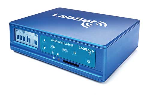
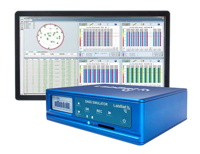
LabSat 3 Wideband. The LabSat 3 Wideband is a compact yet powerful multi-constellation and multi-frequency GNSS testing solution. The easy-to-use, one-touch record-and-replay function provides an efficient way to test and develop GNSS-based technology without the cost and limitations of live-sky signals.
It is lightweight and portable and makes it easy to collaborate with colleagues by sharing scenario files over the internet — making it a suitable testing partner for remote working. Additionally, the removeable solid-state drive (an SSD of up to 7 terabytes) and a two-hour runtime provided by an internal battery is ready for field testing in any environment.
LabSat 3 Wideband can record and replay up to three different channels at 56-MHz bandwidth across all major constellations and signals, including:
GPS: L1/L2/L5
Galileo: E1/E1a/E5a/E5b/E6
GLONASS: L1/L2/L3
BeiDou: B1/B2/B3
NavIC: L5/S-band
QZSS: L1/L2/L5
L-band correction services including SBAS
2x CAN and 4x digital input channels tightly synchronized with GNSS data
Future signal launches are also supported, including L2C, L5 and L1C
SatGen Simulation Software. SatGen software allows users to quickly create bespoke, accurate scenarios with their own time, location and trajectory that can be replayed via a LabSat GNSS simulator.
The latest version of SatGen can be used to create a single scenario containing all the upper and lower L-band signals for GPS, Galileo, GLONASS, BeiDou and NavIC.
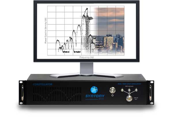
High-end GNSS simulation solutions for R&D, integration and product testing
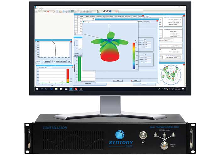
Constellator. Syntony’s GNSS simulator Constellator supports all constellation signals available and provides a high level of service in different ranges. It covers, in a single unit, a wide spectrum of use cases from entry-level with L1C/A up to very demanding configurations such as multifrequency and up to 660 L1C/A-equivalent signals. Extensively used in aeronautics, space and defense industries, Constellator answers complex requirements:
Standalone mode (on the ground and in space)
Multi-frequencies
All constellations and their signals, including BeiDou, Navic/IRNSS and QZSS
Hardware-in-the-loop (HIL) mode with zero effective latency and 1000-Hz update rate
CRPA generation capability
Capability to generate “Restricted Signals” through a dedicated interface, called PRN-Link
In the space industry, Constellator implements the advanced models (Earth gravity, drag, 3D ionospheric models, side lobes, etc.) needed to achieve accurate simulations for all kinds of orbits (from LEO to GEO and SSTO). Combined with other Syntony GNSS simulation products (interference generator, Echo recorder and player), Constellator can tackle challenging use cases such as testing of jamming, spoofing, multipath and multiple antennas. It is based on a software-defined radio, making it hardware-ready for future constellations, signals and codes. It is easily upgradeable and versatile.
GNSS Recorder and player. Echo is an ultra-high-fidelity GNSS record-and-playback solution that captures real-life signals and environments — for instance, from airplanes — and then replays them for R&D or production tests. Echo offers:
3 RF channels of 100-MHz bandwidth each (for the whole set of GNSS signals from all constellations)
16-bit resolution (I&Q)
From seven to more than 1,000 hours of record/replay capabilities depending on the configuration
The Echo platform allows full 16 bits of I/Q recording at 100 Mhz for three channels, simultaneously. As such, it provides the highest achievable record/replay fidelity. Echo-R can also record complex and very long realistic scenarios from a simulator. Echo-P can replay them with very high fidelity for long-run or production tests.
Please contact Remy Thellier (based in San Francisco) for North America at 415.599.9230, or contact the EMEA Sales team at: [email protected] syntony-gnss.com
+33.5.81.319.919
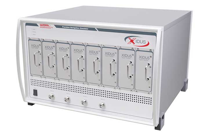
The advanced customization and configurability of Xidus enables users to perform rigorous and extensive testing of GNSS systems.
Test scenarios. Xidus meets all requirements regarding multi-GNSS, multi-frequency and multi-RF signal generation out of the box. Innovative Xidus signal extension and enhancement (SEE) technology allows users to integrate bespoke generation blocks into the signal generation path. In addition, Xidus’ advanced support capabilities allow remote support and updates, remote training and even remote scenario execution.
Easy hardware or software upgrades. Xidus has modular signal generation hardware that allows easy and robust field upgrades. New modules are automatically calibrated, allowing users to accomodate multiple concurrent navigation development projects.
Expert background. WORK Microwave has been designing and building GNSS simulators for more than 15 years. The Xidus hardware leverages WORK Microwave’s 35+ years of experience in the design and manufacturing of bespoke digital and analogue microwave products.
Xidus-Studio (Photo: Work Microwave)
Xidus-424 GNSS Simulator. The Xidus-424 has up to 128 LOS channels, 512 multipath channels and two RF outputs. It supports all GNSS frequencies and signals. It supports an update rate up to 100 Hz and has very wide dynamic power range configurability.
Xidus-648 GNSS Simulator. The Xidus-648 provides all the capabilities of the Xidus-424 plus additional features: up to 256 LOS channels, 1,024 multipath channels, four RF outputs and a 1000-Hz update rate.
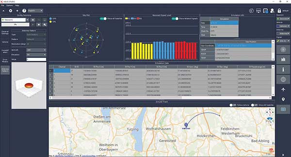
Xidus-Studio client software. The software provides everything for testing GNSS systems: different vehicle models with 6DOF, multiple vehicle simulation, spoofing and meaconing, multiple TX antenna patterns, multiple RX antenna patterns, industry-standard error models and runtime distortions on individual channels. Xidus-Studio also allows the design of bespoke satellite orbits ranging from LEO to GEO. Available on Linux and Windows.
Xidus Series. Connect up to four Xidus units to produce a simulator capable of mega-constellation simulation, with precise phase synchronization across units.
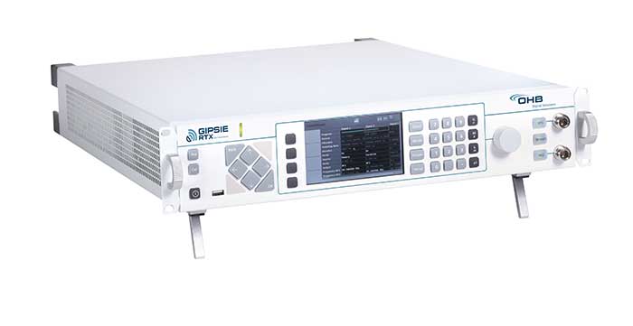
GIPSIE-RTX (GNSS Multisystem Performance Simulation Environment – Real Time Extension)
GIPSIE-RTX is a fully featured GNSS signal generator with real-time streaming functionality, including real-time control of the simulation environment. It consists of a high-quality signal simulator as the hardware platform and a flexible and powerful GNSS simulation environment.
The multi-system and multifrequency-capable GIPSIE-RTX simulates arbitrary satellite orbits using a sophisticated orbit integrator. It is able to model all error sources, delays and propagation effects. These include various models for satellite clocks, ionosphere and troposphere, multipath, signal power, antenna patterns and noise. In addition, multiple types of signal interference, like jamming and spoofing, can be defined. Customized navigation message formats and contents can be used to simulate future GNSS signal features.
Besides generating RF signals, GIPSIE-RTX is also capable of directly simulating digital signals, taking into account user-defined modeling of a radio-frequency front end. Comprehensive data logging of all intermediate results is available for detailed analyses.
GIPSIE-RTX provides a real-time input interface and thus supports hardware-in-the-loop (HIL) testing, such as for automotive applications.
GIPSIE-RTX Features
GIPSIE-RTX is a new compact multi-channel high performance platform for complex and versatile GNSS testing. Features include:
Highly reproducible scenarios
Modeling of all error sources, delays and propagation effects
Interference (jamming and spoofing) simulation
HIL simulation
Synchronization of multiple simulators for advanced testing (e.g., array antenna)
QA707 is the cutting edge solution for global threat GNSS awareness and management. It is a GNSS simulator specifically designed to test cyber-attacks and authentication, and includes the simulation of GNSS interference, deception, jamming, spoofing and advanced cyber-threats such as data and code level attacks.
The high flexibility in the creation of the scenarios and the definition of the type of attacker allow cyber-threat and vulnerability testing for several applications,These applications may include, for example, autonomous driving and vehicle tracking, aeronautics and high dynamics applications, space GNSS receivers and timing.
OSNMA support. The Galileo Open Service Navigation Message Authentication (OSNMA) simulation is an opportunity to test the new Galileo data protected service against a number of known vulnerabilities in GNSS applications. The OSNMA simulator is also available as a standalone tool, allowing the generation of OSNMA data that can be used with third party simulators.
PC-capable. QA707 runs on a standard PC. It is compatible with several third-party hardware RF up-converters, including National Instruments’ USRP. Additionally, it can support customer-specific hardware through the hardware API interface.
QA707 main features
Multi constellation (currently GPS L1, GALILEO E1, SBAS L1).
Galileo OSNMA
RF simulation, binary file dump, signal record and replay
Support to SDR platforms and open API for custom RF upconverters
Runtime streaming of scenario information over UDP (motion, channel data)
Data level cyber-attacks
Accurate spoofing signals control, trajectory spoofing, signal replay attacks
Narrow band, wide band, frequency modulated jamming
Integrity threats (on request): evil waveform, erroneous ephemerides, code/carrier divergence, low satellite signal power, excessive range acceleration
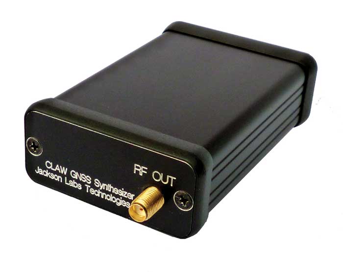
The 18-channel miniature full-constellation CLAW GPS Simulator is a fully self-contained, low size, weight, power and cost (SWaP-C) miniature GPS simulator. It is very popular in manufacturing environments as well as R&D applications that require consistent and repeatable local GNSS signals at low price points.
The CLAW simulator does not require external computers for processing and control — it works fully self-contained by simply applying power, and storing location/time/date data in internal non-volatile (NV) memory, or by storing complex vector data to simulate highly dynamic scenarios.
The CLAW also can be used to transcode NMEA or SCPI position/velocity/time (PVT) data into GPS RF signals. JLT offers an easy to use, highly configurable and cost-free SimCon Windows application program that is downloadable from the JLT website.
The SimCon application allows random scenario generation and is thus usable to simulate leap-second events, week 1023 rollover events, or any other GPS live-sky scenarios, including highly complex yet easy-to-create dynamic vector simulations.
For authorized U.S. government users, a version that does not have altitude and velocity limitations is popular for low-Earth-orbit (LEO) simulations. Multipath simulation allows use of the entire 18-channel simulator capability.
The unit can be field-upgraded with an easy to use in-field software upgrade feature. The CLAW is also very useful in GNSS receiver sensitivity testing for R&D or mass-production assembly lines as it allows accurate control of RF output power ranging from –100 dBm to less than –130 dBm with 0.1-dB resolution and typically better than 1-dB accuracy over the controllable power range.
The CLAW GPS Simulator also has a built-in RF signal generator with sweep, CW and random noise functions that are useful in simulating GNSS jamming scenarios, as well as GPS spoofing scenarios. The simulator comes in an FCC-certified metal desktop enclosure with numerous accessories.
For 2021, the CLAW firmware has been updated to allow live-sky almanac and ephemerides to be automatically uploaded from various externally connected GNSS receivers. This makes simulations using real-time live-sky constellations (such as used in simulating spoofing attacks) an easy task. A free firmware update is available from JLT.
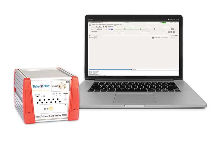
The MGSE product family creates a versatile GNSS test and simulation environment that improves the development, qualification and certification process of GNSS receivers within development phases and for the validation and certification in end-to-end tests.
MGSE enables mobile and stationary interference monitoring, such as for protecting critical infrastructures (based on MGSE REC), and can be used for interference mitigation if combined with TeleOrbit’s GNSSA-6E (six-element antenna array) or its GNSSA-DCP (dual circularly polarized antenna).
With MGSE REC-REP 2.0 users can, among other tasks, record Galileo PRS signals in a real user environment and replay them for Galileo PRS receiver testing. It is also possible to replay simulated GNSS signals.
MGSE SIM-REP supports the development of software-defined radios/receivers (SDR) or specialized algorithms by creating a simulation environment that provides the possibility and flexibility to use synthetically generated GNSS data and recorded real-world samples — both exactly reproducible.
For jamming and spoofing test and evaluation, TeleOrbit offers a sophisticated solution based on the MGSE simulation, recording and replaying product family.
Technical background. The multi-band RF front-end (MGSE REC) receives the GNSS RF signals in different frequency bands simultaneously to obtain digital IF data, which can be used for GNSS multi-system signal analysis and comparison.
MGSE REC also includes a reception board to receive and process the NavIC S-band signal in addition to other L-band frequencies.
The MGSE Replay Unit (MGSE REP) includes a flexible multi-band RF replay device that can stream simulated and recorded raw IF data to a digital baseband output or to an analog RF signal.
MGSE REP simultaneously supports up to two independent RF channels and up to four GNSS signals, such as L1, E1, B1, G1.
To mark the one-year anniversary of the PNT Executive Order, Orolia will host an interactive Coffee Talk webinar on March 24 to explore the latest developments in the national initiative to protect U.S. critical infrastructure from GPS/GNSS jamming, spoofing and interference.
Panelists from the U.S. Department of Homeland Security (DHS) and the National Institute of Standards and Technology (NIST), among others, will focus on key actions and priorities for 2021 and beyond, including insights and context on recently published works such as the NIST Foundational PNT Profile issued on Feb. 11, 2021, and the DHS Conformance Framework of Dec. 18, 2020.
Critical infrastructure and PNT industry panelists will also share their perspectives on practical ways to increase resiliency and key factors to consider, in view of the latest Executive Order guidance.
More information about Resilient PNT and GNSS jamming/spoofing is available in Orolia’s online resource center.
Panelists include:
Ernest Wong, Technical Manager, Science and Technology Directorate, DHS
Jim McCarthy, Senior Security Engineer, National CyberSecurity Center of Excellence, NIST
Register here for the Coffee Talk “PNT Executive Order Update: 2021 Actions and Priorities,” 11 a.m. EDT, March 24. Use the registration form to share questions or comments on what to discuss.
Galileo PRS encrypted signal integrated for first time
Orolia, through its France-based entity Orolia Systèmes & Solutions (O2S), has been selected for the GEODE project to develop European standardized and sovereign Galileo PRS positioning, navigation and timing (PNT) receiver capabilities for military applications.
The GEODE (Galileo for EU Defence) program aims at promoting the competitiveness and innovation of the Defense PNT industry in the European Union.
The GEODE consortium will support the prototyping, testing and qualifying of military PNT technologies and resources such as PRS security modules, PRS receivers, GPS/Galileo PRS compatible Controlled Radiation Pattern Antennas (CRPA), and the development of a European PNT test and qualification facility.
As part of this consortium, Orolia brings its proven track record of developing Galileo-based applications and integrating custom signals for commercial and defense critical infrastructure in the GEARS program, and will now focus on the military use of the PRS signal by leading the critical timing and synchronization applications in the GEODE program.
This new PRS support and qualification infrastructure will ensure that the necessary security resources are in place for operational testing, and PNT testing profiles will be defined for naval, land and remotely piloted aircraft platforms.
The applications targeted for these new technologies and capabilities include tactical drones, military satellite and space technologies, unmanned ground vehicles, high precision missile systems, next-gen naval platforms, airborne electronic warfare solutions, resilient networks, cyber situational awareness, and the latest active stealth technologies.
This project will receive about €44M funding from the European Defence Industrial Development Programme (EDIDP) under grant agreement No EDIDP-PNTSCC-2019-039-GEODE.
“We are proud to support the development of future resilient military technologies that will increase safety and security in the European Union,” said Orolia CEO Jean-Yves Courtois. “As the world leader in resilient PNT, Orolia is uniquely positioned to offer the most advanced technologies for timing, synchronization, and GNSS testing and simulation, including encrypted GPS and Galileo signals.”
Orolia Systèmes et Solutions (O2S). In 2019, Orolia launched Orolia Systèmes and Solutions (O2S), a France-based entity dedicated to providing advanced resilient Positioning, Navigation and Timing (PNT) solutions and custom engineering services to French and EU Defense organizations.
Orolia, through its Orolia Defense & Security business, announced in November 2020 the launch of M-code military GPS receivers in its line of positioning, navigation and timing (PNT) solutions.
The line includes M-code-enabled mobile mission timing and synchronization platforms, such as the SecureSync IDM resilient time and frequency reference solution, the first time server approved by the Defense Information Systems Agency (DISA), and the Versa mobile PNT platform to meet rugged size, weight, power and cost (SWaP-C) requirements.
M-code is a military signal used in the L1 and L2 GPS bands. It is required by congressional mandate for U.S. Department of Defense (DOD) military operations.
M-code is designed to enhance PNT capabilities and improved resistance to existing and emerging threats to GPS, such as jamming and spoofing. Operational benefits of M-code include:
a higher power signal that offers improved resistance to jamming and interference
advanced security features to prevent unauthorized access or exploitation
improved message formats and signal modulation techniques for faster and more accurate performance.
Orolia has long supported the DOD’s need for selective availability anti-spoofing module (SAASM)-enabled PNT equipment, explained Hironori Sasaki, president of Orolia Defense & Security. “This announcement emphasizes our move toward M-code and the availability of M-code in our products,” Sasaki said. “Our focus has always been on staying in sync with the DOD and providing the latest and greatest technologies.”
Orolia now supports M-code in all its user products and offers two capabilities: simulation and M-code-enabled end-user devices. “They will each have a different approval process for export,” Sasaki said. “We follow DOD guidance on getting that capability out there.”
SecureSync, which is SAASM-enabled, has been deployed with DOD for many years, so Orolia has “a very good install base” of these devices, according to Sasaki. “We are providing a very easy and seamless upgrade path to go from SAASM to M-code in that platform.” The company’s Versa platform consists of the VersaSync and the VersaPNT, both small form-factor PNT devices designed for rugged application in military vehicles or military aircraft.
DOD has given Orolia approval to advertise the fact that it has these capabilities in its products. “We are expecting shipments to start in early 2021,” said Sasaki. “So, we are well on our way in development, implementation and productization.”
“We have been focusing on providing products that have a modular architecture, both in software and hardware,” Sasaki added. “We are embracing this approach of open architecture and continue to support the DOD in providing different layers of sensing and PNT protection in a way that can be incorporated into future DOD systems.
“We have already demonstrated our ability to deliver PNT solutions in various form factors, so I think we are in a good position to continue pushing forward with that open architecture approach,” Sasaki said.
Coalition gives voice to PNT companies seeking open-market approach to backing up GPS/GNSS for critical infrastructure
Several GNSS and positioning, navigation and timing (PNT) companies have joined forces to create a new lobbying group, the Open PNT Industry Alliance. Founding companies include InfiniDome, Iridium Communications, Jackson Labs Technologies, NAVSYS Corporation, NextNav, OPNT, Orolia, Qulsar, Satelles and Seven Solutions.
In the United States, the coalition believes the Executive Order on “Strengthening National Resilience Through Responsible Use of Positioning, Navigation, and Timing Services,” issued in February 2020 begins the process for a national alternative PNT policy.
The report was criticized by some lawmakers for inaccuracies and lack of depth, but several companies whose solutions were referenced in the report defended it, and have now joined in creating this new alliance.
The alliance expects to support similar initiatives in other countries.
The coalition is designed to fortify economic and national security by supporting government efforts to accelerate the implementation of backup PNT capabilities for critical infrastructure. Other companies sharing these views are invited to join the alliance.
The Open PNT Industry Alliance will be introduced in an Orolia PNT Coffee Talk webinar on Thursday, Dec. 17, at 10 a.m. EST.
A serious problem facing nations around the world is that GPS and other GNSS are susceptible to inadvertent disruptions and deliberate attacks. Such incidents have the potential to impair or incapacitate communications networks, transportation systems, energy production and distribution platforms, financial services operations and other types of critical infrastructure.
With the scope, complexity and severity of disruptions and attacks evolving continuously, the combination of wide-ranging PNT solutions and emerging technologies offers superior protection to current threats by providing a backup to GPS/GNSS and improving national resilience.
“Multiple forms of alternative PNT deliver the broadest possible range of operational and performance characteristics to meet the diverse needs of applications across all industry sectors, plus they can better adapt to future threats than a single technology with its inherent vulnerabilities,” said Michael O’Connor, CEO of Satelles. “The mission of the Open PNT Industry Alliance is to promote open-market concepts that preserve industry’s long-term ability to harness its inventive talent to protect GPS/GNSS with multiple solutions that are technologically advanced, commercially viable, and based on a sustainable long-term funding framework.”
The Open PNT Industry Alliance will share its expertise with governments to aid their efforts to set policies, define regulations, and enact laws that achieve their national resilience objectives while preserving competition in the open market. A principal purpose of the coalition is to stimulate and capitalize on the collective intellect of industry in a collaboration between the public sector and private sector.
“The ingenuity of the private sector is spurred by competition and public and private investment, and this will drive the emergence of multiple GPS/GNSS alternatives that are cost-effective and evolve according to threat profiles, technological innovations, and market dynamics,” said Jean-Yves Courtois, CEO of Orolia. “Similarly, unbridled innovation will address new and still evolving use cases not supported by GPS/GNSS.”
The coalition will work closely with governments as they consider plans for regulation of critical infrastructure sectors and funding for alternative PNT. Legislators and policymakers can best pursue national interest through a multi-technology approach to PNT resilience, the coalition stated in a press release. The coalition will advocate for the establishment of a robust and self-sustaining funding framework that allows for the development and adoption of multiple sources of PNT that meet the needs of various sectors and industries.
“We believe a multi-technology approach to PNT resilience not only meets a more diverse set of critical infrastructure needs but also ensures a more robust approach to security by providing multi-layer resilience,” said Ganesh Pattabiraman, CEO of NextNav. “Delivering alternative PNT capabilities on an equal footing with GPS will require government policies and funding that ensure these solutions are cost-effective for critical infrastructure providers and sustainable over the long term.”
Flexible, resilient military PNT designed for every military environment
Orolia, through its Orolia Defense & Security business, has announced the availability of M-code military GPS receivers in its resilient PNT products and solutions, including M-code-enabled mobile mission timing and synchronization platforms.
M-code capabilities further enhance Orolia’s Versa mobile PNT platform for rugged, small SWaP-C requirements and Orolia’s flagship SecureSync resilient time and frequency reference solution — the first Defense Information Systems Agency (DISA) approved time server.
M-code is a military signal used in the L1 and L2 GPS bands and is required by congressional mandate for U.S. Department of Defense (DoD) military operations. It is designed to enhance positioning, navigation and timing (PNT) capabilities and improved resistance to existing and emerging GPS threats, such as jamming and spoofing.
M-code offers several operational benefits, including a higher power signal with improved resistance to jamming and interference; advanced security features to prevent unauthorized access or exploitation; and improved message formats and signal modulation techniques for faster and more accurate performance.
“As threats against GPS increase, military forces will need M-code capabilities on mobile PNT systems to ensure continuous operations wherever they go,” said Hironori Sasaki, president of Orolia Defense & Security. “Orolia is proud to continue to support Department of Defense initiatives to ensure that warfighters have the most secure, reliable and accurate positioning, timing and synchronization solutions in any environment.”
From resilient PNT solutions to GPS/GNSS simulation, interference detection and mitigation, Orolia provides end-to-end NAVWAR and resilient PNT solutions to protect, augment and strengthen military systems for GPS-denied environments.
The ROSS project, conducted in France by companies Marlink and SeaOwl, demonstrated the feasibility of autonomous shipping. Orolia systems ensured resilient PNT. (Photo: Marlink)
The International Maritime Organization (IMO) has issued a resolution for maritime cyber-risk management, effective January 2021. IMO Resolution MSC.428(98) affirms that maritime operators need to address cyber threats that risk the integrity and availability of technology systems.
GPS/GNSS signal jamming and spoofing expose the vulnerabilities of PNT-reliant systems. The single point of failure in the signals used to synchronize military operations or determine a vessel’s location leaves maritime systems open to attack. With resilient PNT, maritime and naval vessels can rely on trusted data.
Remote Operations at Sea. In September, Orolia participated in a Remotely Operated Service at Sea (ROSS) demonstration where an unmanned vessel was tele-operated from more than 800 kilometers (500 miles) away.
With its SecureSync Interference Detection and Mitigation (IDM) suite, Orolia provided the project’s PNT cybersecurity package and delivered precise, reliable data for the control center to pilot the vessel from afar. The IDM suite includes GNSS threat detection and mitigation, as well as the option to include encrypted and alternative signals for use in GNSS-denied environments.
After this successful demonstration, SeaOwl Group, the company leading the ROSS project, obtained the first remotely operated vessel navigation license in France.
Diving Deep. Atomic clocks and oscillators are useful for underwater operations where RF signals are unavailable to provide accurate PNT data. Precision timing technologies, such as Orolia’s Spectratime mRO-50 oscillator, ensure stable timing for navigation systems through radar. They support missions such as:
stabilizing and synchronizing sensor measurement data collection for autonomous underwater vehicles (AUVs)
providing holdover to maintain precise positioning on submarines during extended periods of GNSS signal denial
generating precise frequencies with low phase noise and less burden on radio receiver architecture, such as search-and-rescue control centers
operating with low power consumption and increasing the reliability of radio reception.
Resilient PNT is essential at sea, from military missions and commercial freight shipping to port management, search and rescue, research and fishing operations. Jamming and spoofing detection, threat mitigation, and alternative PNT sources configured in multiple layers of protection can ensure continuous operations, even in compromised environments. In shallow or deep-water environments, Orolia’s portfolio includes critical infrastructure support for naval command-and-control centers, essential GNSS vulnerability testing and services, and wearable solutions that fit in the palm of a hand.
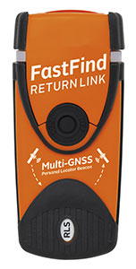
The first Galileo Return Link Service Personal Location Beacon (PLB) developed under the H2020-funded Helios project will be released in December across 19 European countries.
In close collaboration with the European GNSS Agency and within framework of the H2020 HELIOS project, Orolia has been working to equip search-and-rescue beacons with the breakthrough Galileo Return Link Service.
Declared operational in January, the Galileo Return Link Service is a unique feature of Galileo, allowing people in distress to receive an automatic acknowledgement that their signal has been received and their location is known.
How It Works
The FastFind ReturnLink PLB transmits the user’s unique ID and GNSS location via the global network of Cospas-Sarsat search-and-rescue satellites. When a person in distress activates the emergency beacon, the Galileo satellites capture the signal and transmit it to a set of ground-segment facilities — the Galileo Return Link Service Provider (RLSP) based in Toulouse, France.
Once the location of the person in distress is determined, an automatic message is sent through the Galileo satellites, confirming to the user that their position has been detected and the information has been routed to the relevant government authorities. With the FastFind ReturnLink PLB, the person in distress — on land or at sea — will see a blue light blinking on their beacon 10-15 minutes after confirmation that the distress signal and location has been detected.
”At the GSA, our objective is to ensure that EU Space investments and our work on Galileo services are bringing added value to citizens,” said Rodrigo da Costa, GSA executive director. “With the first search-and-rescue beacon worldwide deployed thanks to the H2020 project Helios, we can proudly state that our actions made a difference for innovation but also for the citizens. The ones who need to use this Personal Location Beacon will be reassured by the Return Link Service.”
Cospas-Sarsat rescue beacon activated. Its signals are picked up by satellites in orbit, including Galileo. (Photo: GSA)
Galileo a SAR Game Changer
Galileo’s immediate impact on search and rescue (SAR) has been the addition of 26 new satellites, allowing for greater global coverage and faster detection of the 406-MHz distress frequency. Coupled with Galileo’s robust signal, SAR beacons deliver greater positioning accuracy.
Galileo’s development is part of the European Union’s preparations for upgrading the international distress beacon locating organisation Cospas-Sarsat’s Search and Rescue (SAR) Ecosystem under the MEOSAR program, which requires new Earth-based antenna and a network of 72 GNSS satellites, combining GPS, the EU Galileo and the Russian Glonass systems. The Return Link Service is a unique feature provided by Galileo within its contribution to Cospas-Sarsat.
Survival Booster
By sending a confirmation to the user that the distress signal from the beacon has been localised by the Cospas-Sarsat system and the information relayed to the relevant Search and Rescue l authorities, the Return Link Service provides confidence and reassurance to the people in distress that help is on the way.
“The Search and Rescue community has long known the survival impact of dealing with a distress situation on your own, either as a solo adventurer or as a group that feels isolated due to the lack of communication with the outside world,” said Chris Loizou, vice president of Maritime at Orolia. “The Return Link reassurance signal will reduce the chances of rash decisions taken by those who feel they have nothing to lose, such as leaving the site of an accident or attempting to swim to safety. The psychological impact of knowing that help is on the way cannot be underestimated, and this PLB will provide invaluable peace of mind for those in distress.”
The Galileo Return Link Service increases survival rates by giving an important psychological boost to people in distress. It is estimated by Cospas-Sarsat that the international SAR system, with the contribution of the Galileo Search and Rescue service, saves more than 2,000 lives a year.
Countries Included
The beacons will be sold in the following countries.
Croatia
Cyprus
Denmark
Faroe Islands (DK)
France
Germany
Greece
Greenland (DK)
Iceland
Ireland
Israel
Italy
Latvia
Liechtenstein
Norway
Sweden
Switzerland
United Kingdom
Eventually, the RLS-enabled beacons will be available in most countries in the world.
Flight simulators range in price from free to tens of millions of dollars and in purpose from pure entertainment to serious business — such as learning to fly multi-million-dollar aircraft without crashing them in real life and getting anyone killed. Military and commercial pilots spend thousands of hours in simulators learning both routine operations and how to deal with emergency situations. They can become fully proficient through immersive training in these virtual environments. The U.S. Army, Air Force, Navy and Marines all use flight simulators to train pilots to fly in battle, recover in an emergency, and coordinate air support with ground operations. To do this, they use hardware and software developed both by military agencies and by commercial military contractors.
In high-end flight simulators, the trainee steps into a life-size replica of a cockpit, whereas others consist of several monitors that cover the trainee’s field of view, or, at the lowest end, everything is crammed onto a single monitor. All flight simulators, however, are designed to replicate as closely as possible the layout and controls of a real aircraft. (Ironically, the $120 Microsoft Flight Simulator Premium Deluxe Edition lets you fly 35 different planes, while flight simulators that cost tens of millions of dollars are limited to a few models because they have to physically replicate the cockpit layout, which varies from aircraft to aircraft. Some training centers invest in multiple simulators, while others privilege convenience over accuracy and use a single simulator model.)
Most professional flight simulators sit on top of either an electronically-controlled motion base or a hydraulic lift system that rotates the replica cockpit in three dimensions in reaction to both user input and simulated events. This provides trainees with haptic feedback, in other words, feedback they can feel. (Another example of a device that provides haptic feedback is a joystick with force feedback.)
Like when learning to sail offshore or to survive in the wilderness, a large component of any pilot training program is navigation. For flight simulators, this involves detailed aeronautical charts, huge amounts of Earth observation imagery including thousands of airports, and faithful replicas of several cockpit navigation instruments. While aviation programs provide standard training to ensure pilots can handle situations ranging from enemy fighters to bird strikes to engine failure, they may overlook the importance of duplicating actual cockpit instruments rather than relying on facsimile ones.
Simulating GNSS signals
This is where GNSS simulators come into play. They make it possible “to simulate the actual GPS signal required by the cockpit navigation instruments,” according to a case study by Orolia.
This approach, the company points out, offers advantages to both the trainees who use flight simulators and the engineers who develop them. For a trainee, “the advantage is that he is trained using the identical instruments as those in the actual airplane […] providing the same feedback as a real-world experience.” For an engineer developing a flight simulator, GNSS simulators make it possible to “design more effective flight simulation programs without compromising quality.”
Furthermore, “using real navigation instruments may […] reveal unexpected behavior from the instrument, which helps the pilot to be prepared for this possibility. If any conditions involving the plane dynamics are not properly handled by the navigation unit, the pilot can obtain actual feedback from real navigation instruments, which could differ from feedback provided by a facsimile instrument.”
Hardware-in-the-loop (HWIL) techniques enable Orolia to integrate its simulator in a flight simulator to reproduce the GPS/GNSS dynamics for the airplane in real time. “Because the pilot steers the aircraft in real time, the GPS simulator must also simulate GPS signals in real time, forming an HWIL integration,” the company said. “This integration enables the flight simulator to integrate the actual navigation unit to provide a very realistic environment for the trainee.”
Racelogic, another manufacturer of GNSS simulators, is launching a new RealTime LabSat that can connect to Microsoft Flight Simulator, including the new 2020 version. “This will create a live GNSS RF feed that accurately follows the trajectory in the simulator, enabling the testing of any GNSS device as though it were being flown on the aircraft,” said Julian Thomas, the company’s managing director. “To help make this a cost-effective solution, we have recently optimized our SatGen signal simulation software so that a real-time simulation such as this can be carried out on an entry-level PC with a full constellation of simulated satellites.”
The GNSS and flight simulation industries overlap even further. For example, Garmin, which manufactures consumer GPS receivers, makes the avionics used in some professional flight simulators.
Simulator demand on the rise
The utility of simulators is not limited to training human pilots and drivers. The demand for simulation is being sharply increased by the development of autonomous vehicles of every kind — from self-driving cars to unmanned aerial vehicles (UAV), from bathymetric vessels to urban air mobility (UAM) aircraft.
For example, manufacturers of self-driving cars need to simulate driving millions of miles, in all kinds of traffic and weather conditions, to perfect their vehicles’ algorithms. The result of all these simulations is better trained human and robotic pilots and drivers prepared for real situations, superior mission readiness, and maximum safety for both military and civilian operations on land, at sea and in the air.
Feature image: In a simulated G1000 NXi integrated flight deck for a King Air 350, a pilot refers to the Garmin Pilot app, used as a supplement during flight. (Photo: Garmin)
The number of GNSS constellations, satellites and signals is constantly growing. The threats to GNSS — from unintentional radio frequency interference (RFI), jamming, spoofing, multipath… and Federal Communications Commission rulings — are increasing, as are the public’s expectations of GNSS accuracy.
All these factors contribute to the need for ever more powerful and advanced simulators that can realistically simulate a wide range of optimal and suboptimal environments. That is why simulators are a rapidly growing sector of the GNSS industry.
At present, the main defense against jamming are continuous radiation pattern antennas (CRPA). Therefore, it is essential that simulators be able to accurately reproduce signals from CRPAs. They are even more useful when they can generate M-code (MNSA) signals, which not all simulators do.
Additionally, the development of autonomous vehicles requires engineers to simulate driving millions of miles, under a variety of environmental and traffic circumstances. To accomplish this in a reasonable amount of time requires them to run simulations faster than in real time, or run many simulations in parallel.
Finally, there is an increasing need to simulate alternative positioning, navigation and timing (PNT) signals being developed as supplements to and substitutes for GNSS signals in circumstances that make the latter unavailable or unreliable.
These are some of the challenges facing manufacturers of GNSS simulators. What follows are their brief descriptions of the approaches they are taking and the innovations they are introducing.
What is your most recent innovation?
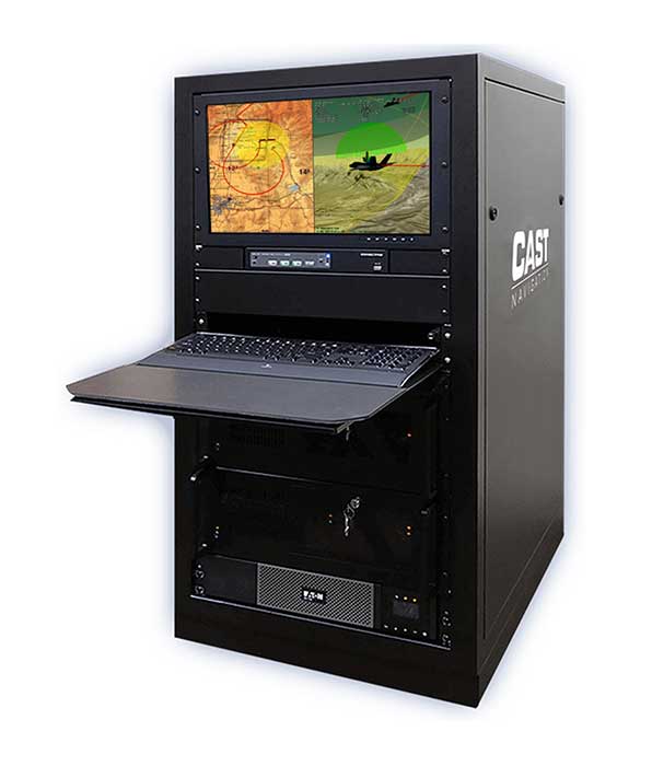
Our latest simulator innovations contain wave-front generation signal technology, which allows you to generate GNSS and interference signals that represent the received signals for each antenna element in a phased array antenna manifold, usually referred to as a controlled radiation pattern antenna (CRPA). Our modular design approach enables users to simulate IMU data commensurate with the wave-front signals for a complete coherent GNSS/IMU simulation that is ideal for stimulating receivers that contain CRPA and IMU capabilities. Our simulators also contain proprietary synchronization technology that allows users to synchronize multiple systems to produce a “wave-front” of GNSS and IMU signals for multiple vehicles, or even an entire fleet.
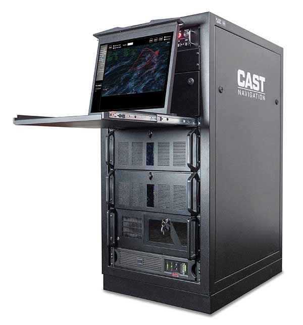
Photo: CAST Navigation
What is your approach to jamming and spoofing?
CAST Navigations’ family of GNSS simulators are capable of realistically simulating a wide range of suboptimal conditions—such as jamming/spoofing, multipath, RF interference and satellite constellation perturbations—for virtually any commercial or military environment. Our interference signals or “jammers” can be located at any terrestrial location and can be static or dynamic in nature. A distinguishing feature of CAST Navigations’ simulation systems is that our interference signals are phase-controlled and coherent, allowing for proper phase transmission of each signal type for each receiving antenna element. You can also add an INS capability to any of our systems. These types of systems are perfect for testing GNSS and GNSS/INS types of navigation equipment.
What’s coming by 2023?
One of the key trends is the ability to generate M-code (MNSA) signals. Jamming and spoofing are becoming more prevalent, not just to the military but also to consumers. Every day, the military, as well as people like you and me, are starting to encounter more instances of interference that can deny GNSS equipment and even phones the ability to track some GNSS satellites or that transmit incorrect GNSS data, causing receivers to display incorrect position solutions. So, our focus is on products and capabilities that enable our customers to simulate those types of environments and help them to mitigate those kinds of events.
Orolia
Lisa Perdue Product Manager
What is your most recent innovation?
At Orolia we continue to evolve our innovative software-defined simulator approach. Our most recent innovation is our advanced spoofing option. We have taken our ability to define multiple jamming transmitters, each with their own trajectory and antenna pattern, and added the ability for the transmitters to send spoofing signals as well. By utilizing our capability to run multiple simulations on a single system, we give the user the ability to control every parameter of the generated spoofing constellation(s). The system automatically calculates the signal time of flight and the propagation loss, making this advanced capability powerful and easy to use.
What is your approach to jamming and spoofing?
Simulation of threat environments is a critical component of GNSS receiver testing. As awareness of the impact that jamming and spoofing can have on a GNSS-based system rises, so does the need to test. That is why we have implemented advanced jamming and spoofing options into our Skydel simulator’s core engine. Replication of degraded environments with threats ranging from one to hundreds is possible using the same hardware and software used for generating GNSS signals. No third-party hardware or software is required for complete testing against jamming and spoofing because we feel that this capability should be part of the core system, not an afterthought.
Photo: Orolia
What’s coming by 2023?
In the coming years, we expect to see more requirements for simulation of alternative positioning, navigation, and timing (PNT) signals. As governments and organizations continue to investigate alternate technologies, it will become necessary to simulate low Earth orbit (LEO) PNT, ground-based transmitters, and other signals being considered.
Another growing trend is the adoption of controlled reception pattern antennas (CRPAs) for their anti-jam capabilities. These anti-jam antenna systems can only be tested by specialized simulation systems, so we can imagine these simulation systems being commercialized for a broader market around 2023.
Racelogic
Julian Thomas Managing Director
What is your most recent innovation?
Recognizing the need of our customers to test their products with a simple solution that uses the latest GNSS signals, we have updated our SatGen software to create accurate simulations using all satellite data currently being transmitted across the various constellations. We have also optimized the performance of SatGen so that a standard desktop PC can be used to simulate these signals in real time. Also, the simulation can now be driven using an external NMEA stream, allowing full remote control of the trajectory.
What is your approach to jamming and spoofing?
The LabSat 3 Wideband records and replays all available GNSS signals in high fidelity, allowing jamming and spoofing signals to be reproduced accurately on the test bench.
Photo: Racelogic
What’s coming by 2023?
With so many employees now working from home due to COVID-19, the pressing concern for many companies developing GNSS technology is how to provide employees with suitable equipment that is required for them to carry out their jobs efficiently away from the office. Usually these employees would utilize the shared resources of a well-equipped office, with experts on hand to help, but working from home has made access to these devices challenging. Due to LabSat 3’s small size, low cost and ease of use, we have seen a significant increase in sales to companies furnishing their employees with a suitable method of testing their GNSS devices while working from home.
With the advent of a new breed of high-performance, low-cost GNSS receiver, many new applications are being developed in new and exciting sectors, utilizing a level of accuracy previously considered too expensive to be a commercial proposition. The number of GNSS engines will therefore increase rapidly in the marketplace, with a corresponding increase in demand for cost-effective signal simulation for test and development.
Rohde & Schwarz
Markus Irsigler Product Manager Signal Generators, Power Meters
What is your most recent innovation?
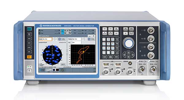
We further improved multi-frequency, multi-constellation simulation capabilities in our high-end segment. The GNSS high-end simulator R&S SMW200A provides signals for all GNSS frequency bands on a single RF output. A second internal RF path can be used for advanced interferer simulation, testing the receiver’s resilience to spoofing or to address dual-antenna scenarios. This keeps setups simple and compact. When more than two RF paths are required, two or more R&S SMW200A can be operated together in a master/slave configuration. Such setups are required for multi-antenna receiver test applications where the signals’ relative carrier phases are analyzed, like CRPA or attitude determination tests. Our new RF ports alignment software automates alignment of the GNSS signals and guarantees correct amplitude, time and phase relations at the RF inputs of the device under test. We also increased the maximum channel count to more than 600 channels to improve testing of multi-constellation, multi-frequency receivers against multipath, jamming and spoofing.
What is your approach to jamming and spoofing?
Besides our recent innovations, Rohde & Schwarz plans to provide new interference simulation capabilities within the GNSS simulator. This new feature will allow the user to replay recorded jammer signals as well as user-defined waveforms. The R&S Pulse Sequencer software helps with the definition of most complex interferer scenarios.
Photo: Rohde & Schwarz
What’s coming by 2023?
Developments in the field of advanced driver-assistance systems (ADAS) aiming for fully autonomous vehicles raise new challenges for reliable PNT solutions. Simulation of interference and jamming scenarios will hence become important in the automotive market. Antenna arrays have proven suitable to counteract RF interference (RFI) by incorporating spatial-processing techniques and might therefore find greater entry into the automotive market. Test solutions must address requirements for simulating all kinds of intentional and unintentional RFI for multi-constellation, multi-frequency and multi-antenna receivers. Apart from simulating GNSS and interference sources, test solutions for autonomous driving will require several other techniques and signals to be applied or simulated, such as RTK/PPP or outputs from other vehicle sensors to perform sensor fusion.
Spirent Federal Systems
Jeff Martin Vice President, Sales
What is your most recent innovation?
Launched in 2018, SimMNSA became the first MNSA simulator to achieve GPS Directorate security approval. The software enables users to simulate true MNSA M-code with real-time code and message generation, removing the constraints imposed by simulator data sets (SDS). SimMNSA v2.0 does even more. It is able to broadcast nominal M-code conditions and recreate SDS-defined events. It incorporates an advanced editor to edit military navigation (MNAV) content, allows users to craft and define scenarios, and much more.
What is your approach to jamming and spoofing?
Spirent offers numerous capabilities for emulating GNSS signals in the presence of interference and spoofing attacks. Our solutions provide accurate, repeatable and quantifiable signals, enabling customers to conduct accurate tests with trusted results. We can test against internally generated interference enabling multiple “fields” of jammers with various interference types; hundreds of interference signals using external IQ blended with simulator-generated GNSS, and Blue Force Electronic Attack jamming waveforms for testing MGUE devices operating in GPS-denied environments. Spoofing capabilities include signal, navigation data and cyber-level attacks via manipulation of up to 12 copies of each primary GNSS constellation, each fully editable; intuitive spoof attack generation via Spirent’s SimSAFE software option — which also allows live sky synchronization/spoofing, and more.
Photo: Spirent
What’s coming by 2023?
Threats to reliable and accurate GNSS navigation and timing are developing rapidly. Fortunately, innovative solutions for resilient PNT are in development and will continue to challenge the industry for years to come. The ability to simulate these threats and the mitigation techniques to overcome them is changing the landscape for the simulator industry. It’s more important than ever to have up-to-date test tools. Robust signals along with frequency and constellation diversity will continue to drive the market in addition to GNSS backup systems, or AltNav. The FCC has certainly presented the GNSS industry with an immense challenge.
Syntony GNSS
Sylvain Daubas Simulator Activity Manager
What is your most recent innovation?
Yesterday, GPS systems had to “work.” Today, they must work fine. This is the difference, and all equipment vendors have realized this. It is no longer acceptable to have 200 meters or more of error in an urban environment. Because of the extreme complexity of the electromagnetic situation in the GNSS spectrum, making a reliable and precise location system requires more and more powerful and advanced simulators. This is why the GNSS simulator market is booming.
Among the many new features implemented in Syntony’s GNSS simulator this year, two stand out.
First, 1000-Hz hardware-in-the-loop now allows an accurate simulation for high-dynamic receivers (up to more than 100 Gs!), with zero artifact and zero-effective latency. This is the ultimate in trajectory management.
Second, signal computing capacity has made a significant leap forward due to hardware and software optimizations. Constellator can now simultaneously generate up to 660 L1 C/A-equivalent signals. And this level of performance can be unlocked remotely, without a hardware update.
Photo: Syntony GNSS
What is your approach to jamming and spoofing?
Simulating a GNSS environment with a set of jamming or spoofing signal sources today is the standard. But what about a simulation of an extremely complex urban scene with 50 or 100 jamming/spoofing sources? The only reasonable solution to implement this would be a massive parallel software-defined radio (SDR)-based simulator solution. This is what Syntony can and will do, thanks to its full software GNSS simulator architecture, which can be distributed on a server farm.
What’s coming by 2023?
A revolution is arriving: the possibility of generating a full GNSS simulation including many hundreds of satellites and signals, in real time and in pure software. This is now possible, and Syntony has demonstrated it with the Constellator. This will change the simulation world. First of all, Moore’s law will bring significant improvements to this domain year after year. More importantly, new systems and services will be possible: massive parallel scenario simulation including jamming and spoofing, floating simulator licenses, software as a service, etc. In this trend, playback machines will be needed, and obviously a strong internet connection will be necessary to download hundreds of gigabytes of I/Q files overnight.
Feature image: Samuel King Jr./United States Air Force
Orolia Defense & Security has been granted security approval by SMC Production Corps. for BroadSim MNSA (modernized Navstar security algorithm).
The company delivered its first batch of MNSA M-Code to multiple customers in late August. BroadSim MNSA joins P(Y)-Code and AES M-Code as another GPS encrypted signal that Orolia Defense & Security supports, the company said.
Thought, skill, and patience went into developing this solution,” said Tyler Hohman, director of products at Orolia. “Not only have we taken an innovative approach to ensuring the security of this technology, our implementation was designed with ease of use being top-of-mind — from procurement, to delivery, to installation, to testing — so our customers can spend more time supporting their mission and less time making their simulator work.”
According to Orolia, BroadSim is a proven and trusted solution among government, Department of Defense and military customers with more than 100 systems fielded. BroadSim was recently selected by the U.S. military to support diverse testing of military GPS receivers, the company added.
BroadSim MNSA users receive a step-by-step guide allowing them to effortlessly set-up and generate MNSA in minutes and quickly downgrade the system on a moment’s notice, Orolia said.
The capability is currently available as a software upgrade to current BroadSim users or as a purchase alongside Orolia’s BroadSim hardware platform.
Orolia Defense & Security, which operates as a proxy-regulated company and wholly-owned subsidiary of Orolia, provides resilient PNT solutions to U.S. government agencies, defense organizations and their contractors.