The PNT Coffee Talk event will be held online and is open to those interested in learning more and discussing this national priority from the industry and government perspectives.
The Executive Order, issued Feb. 12, is a federal initiative to protect critical infrastructure from GPS/GNSS jamming and spoofing threats, and other disruptions to critical PNT services. These threats can deny access to, or compromise, essential PNT data that critical infrastructure needs to operate.
This initiative, titled “Executive Order on Strengthening National Resilience through Responsible Use of Positioning, Navigation and Timing Services,” includes the following critical infrastructure: defense, homeland security, transportation, power grids, communications/mobile, precision agriculture, weather forecasting and emergency response.
Key actions include assessing jamming, spoofing and other PNT disruption risks across these critical infrastructure programs, developing customized PNT profiles to address risks, and deploying Resilient PNT technology to increase resilience.
Survey seeks feedback. Orolia asks those interested to share questions and comments and let the company know what you’d like to discuss during this PNT Coffee Talk event through an anonymous survey.
A roundup of recent products in the GNSS and inertial positioning industry from the April 2020 issue of GPS World magazine.
OEM
LPWA module
Collaborative IoT solution
Photo: Quectel
Quectel Wireless Solutions’ LPWA module BG95 is being integrated with Microsoft’s Azure Device software development kit (SDK). The BG95 cellular module is based on the Qualcomm 9205 LTE modem. The integration will provide direct and secure connections to the Azure IoT Hub and provide full support for Azure device management. Customers can connect their BG95 devices to the Microsoft Azure cloud where they can build, manage and deploy internet of things (IoT) solutions at scale, significantly accelerating time to market. The BG95 module is a highly integrated variant supporting integrated GNSS, Cat M1, Cat NB2 and EGPRS (also called edge). The module complies with 3GPP Release 14 and delivers improved capabilities in power consumption, data rates and hardware-based security.
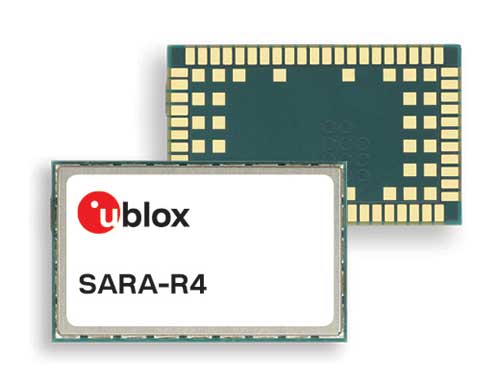
The SARA-R422 product series of LTE-M/NB-IoT and EGPRS cellular modules now include GNSS variants for internet of things (IoT) data, devices and ecosystems. The SARA-R422M8S module is pre-integrated with the u-blox M8 GNSS receiver and a separate GNSS antenna interface. This provides highly reliable, accurate positioning data simultaneously with LTE communications. The module also supports hybrid positioning strategies, in which positioning data provided by satellite constellations is enhanced with data from the u-blox CellLocate service, ensuring that location data is always available everywhere. The SARA-R4 series is designed for a wide range of mission-critical IoT solutions such as connected healthcare, industrial monitoring, point of sale and vending terminals, tracking and telematics devices, as well as smart lighting solutions and building automation.
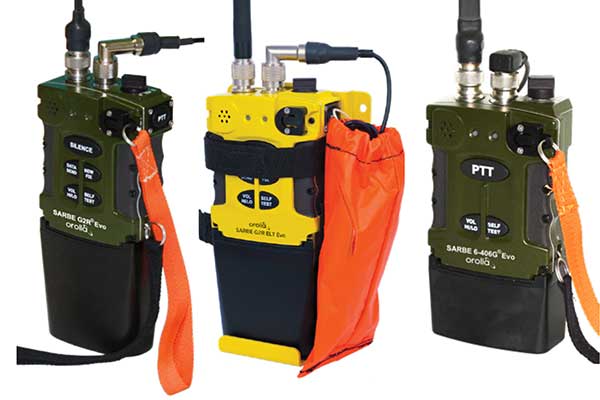
The new line of Sarbe search and rescue beacons. (Photo: Orolia)
Orolia has improved its Sarbe Evo search-and-rescue (SAR) beacon range line to deliver upgraded operational capabilities. The line offers new operational improvements to meet revised Cospas-Sarsat requirements in operating lifetime, location accuracy, voice signal management, integrated protocols, testability and maintenance. Also a focus of the upgrade was more robust and frequent GPS/GNSS position acquisition with the GPS, Galileo and GLONASS satellite constellations.
ADVA’s GNSS assurance solution could help companies dependent on satellite-based timing. (Photo: Business Wire)
ADVA’s GNSS assurance solution helps companies dependent on satellite-based timing. The centralized GNSS monitoring and assurance tool uses artificial intelligence and machine learning for comprehensive predictive maintenance. The customer-owned tool enables users to collect and analyze huge amounts of information from across the network to remotely identify issues and protect networks from GNSS vulnerabilities, including jamming and spoofing attacks. It also helps to identify GNSS obstruction issues, detect blind/poor spots that appear over time, and enable optimal antenna positioning. Built into ADVA’s Ensemble Controller network management suite with Sync Director, the solution enables customers to detect potential problems in advance and maintain the highest quality of network synchronization. It complements the limited distributed approach to GNSS assurance with a centralized global system, providing a boost to critical infrastructure now dependent on satellite-based timing.
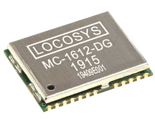
The Locosys MC-1612-DG is a single-band multi-system with an ARM-based processor that supports GPS, GLONASS, Galileo, QZSS and SBAS. The embedded micro-electro-mechanical systems (MEMS) sensor is equipped with dead-reckoning software and provides six-axis accelerometer and gyroscope data. The extended Kalman filter algorithm combines GNSS and MEMS sensor data with a weighting function that relies on GNSS signal quality. In adverse GNSS conditions such as urban canyons, tunnels or parking garages, the dead-reckoning features boost accuracy with the software filling the gaps. It supports three-dimensional dead-reckoning and standard NMEA output, and has Flash memory, TCXO, RTC crystal, LNA and SAW filter.
The automotive-grade solid-state RS-LiDAR-M1 family has the performance advantages of traditional mechanical lidar, while meeting requirements for mass-produced vehicles. The RS-LiDAR-M1Smart is embedded with an artificial intelligence perception algorithm that transforms conventional 3D lidar sensors into a full data analysis and comprehension system, outputting semantic-level structured environment information in real time for autonomous vehicle decision making. The RS-LiDAR-M1Smart outputs two redundant channels of data: the original point cloud and the object list. The redundacy provides vehicles with a range of sensing results — dynamic, static, inside and outside the road. Also available is the RS-LiDAR-M1Simple.
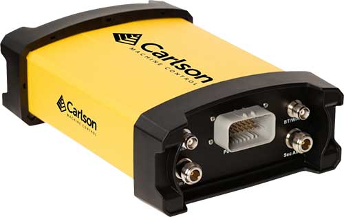
The Vsx7 multi-frequency position and heading receiver is designed specifically for machine control and can be mounted by bolts or with magnets on heavy equipment. Paired with the Carlson A45 antennas, the Vsx7 features high-precision positioning in Athena RTK, Atlas L-band and SBAS and heading accuracy of up to .01 degrees. The whole Vsx7 system is designed to operate in harsh conditions from –40° F to +158° F. The Vsx7 is primarily used in the mining and construction industries, but can be used in similar industries with companion software, Carlson Grade. Field data can be collected and viewed in real time both at the machine with either the MC8 or MC10 control box as well as in the office with Carlson Command.
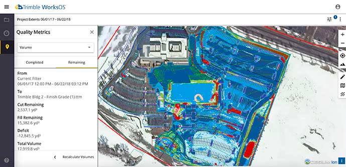
Trimble WorksOS is a new Software-as-a-Service (SaaS) operating system. The cloud-based system will integrate data from Trimble and third-party providers across the entire civil construction project lifecycle, including estimating, scheduling, designs and the field. Currently, site supervisors and project managers jump between multiple systems to keep track of daily production quantities, labor/equipment hours and equipment maintenance schedules. Works OS is designed to bring real-time visibility into jobsite progress, schedule and cost. Users will be able to log into a single application to view real-time visibility of cut, fill, volume and compaction data to maximize jobsite productivity. Site supervisors will see daily volume calculations and compaction quality metrics, and be able to monitor progress and schedules.
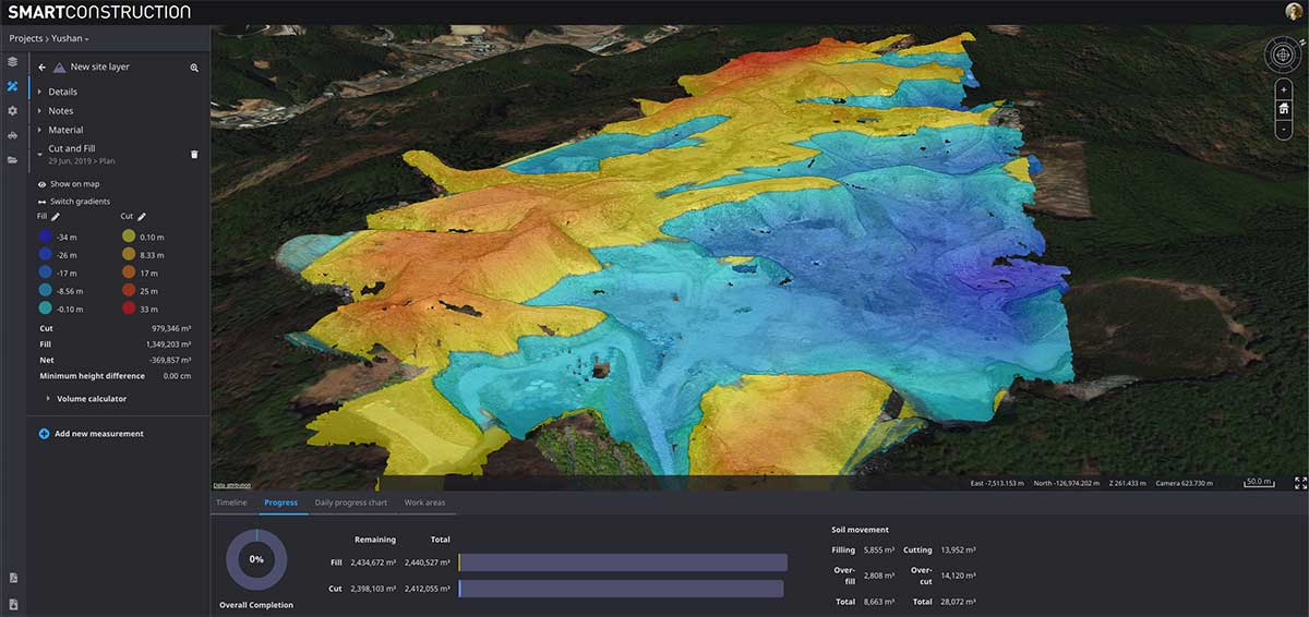
Komatsu’s Smart Construction dashboard includes the 3D visualization power and geospatial accuracy of Cesium, a platform to visualize, analyze and share 3D data. The dashboard enables users to monitor a construction site from anywhere in the world, see how it changes over time, and compare architectural plans with real-world data. It is compatible with data from sensors on construction machines, drone surveys, or computer-generated files like BIM/CAD models . It allows users to visualize projects in a single scene within a web browser, as well as calculate precise measurements for cut and fill, slope, contours and more.
Cesium, cesium.com
The TopoGrafi app has been updated to allow for display of 3D data in real-world models. With enhanced 3D data-processing capabilities, TopoGrafi is an end-to-end platform for capturing buried asset data and processing it for augmented reality visualizations. Designed to be used alongside apps such as Esri Collector for ArcGIS, the TopoGrafi platform uses GNSS data. It applies near-real-time conversions, transforming the recorded positions to local reference systems and aligning it with high-accuracy mapping including Ordnance Survey MasterMap. The TopoGrafi toolkit also includes functionality to snap 3D features to each other and to other spatially referenced data to create a 3D model that can then be used to create augmented reality visualizations accessible from the desktop or in the field.
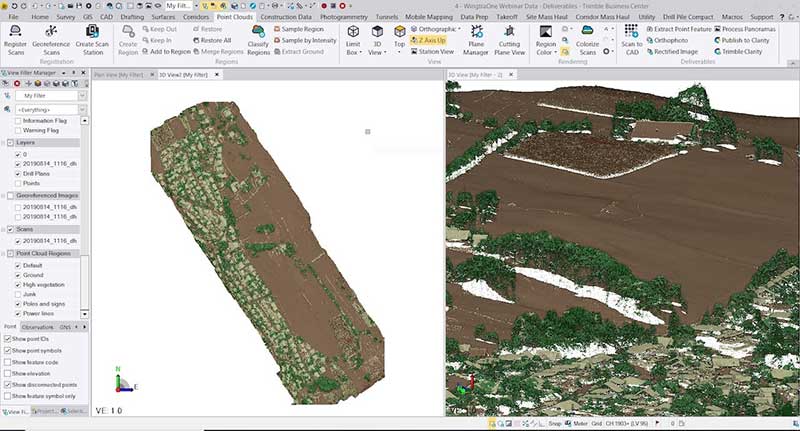
WingtraOne drone data can now be directly imported into the Trimble Business Center (TBC). The new integration combines WingtraOne high-accuracy drone data within TBC, optimizing drone mapping workflows for survey and construction projects within a single software platform. After dragging and dropping the JobXML data file, automated point cloud tools, such as classification and feature extraction, can quickly generate surface models, topographic plans and as-built deliverables. Also new: high-altitude flight capabilities, longer flight times and more intuitive battery-level readings in-flight.
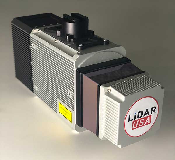
The Snoopy CL-360 lidar scanner. (Photo: Lidar USA)
The Snoopy CL-360 has been meticulously designed for integration on backpack, vehicle and UAV applications. Weighing 5 kilograms fully assembled, the Snoopy CL-360 is capable of delivering highly accurate results, up to +/-0.01 feet on paved surfaces from a vehicle. The system has a scan line rate of 250 Hz with a 500-kHz data rate, giving a uniform result along and across track. The system is easily configurable with multiple scanners (similar to internet of things applications) to avoid occlusions. A UAV deployment achieves scans with usable data as much as 60 degrees off nadir (widths of more than 1,100 feet while scanning at the 400-foot ceiling). The small beam size of 0.3 mrad allows the CL-series to reliably collect ground points (such as on or near the dirt through vegetation) while also providing better detection of fine linear features such as power lines and railroad tracks.
The E300 Pro receiver tracks GNSS with 700 channels and fully supports BDS-3 signals. It supports 31 frequency points, using all GNSS constellations and frequency bands. The E300 interface has a concealed design for better protection. USB type-C charging and transmitting is a two-in-one function. The magnesium-alloy body is rugged, and the battery level can be checked with a unique LED power indicator. The weight of the whole receiver is 940 grams. The E300 Pro supports satellite station differential and satellite chain life, quick connection, intelligent voice and tilt compensation. It integrates multiple sensors including GNSS, an inertial measurement unit (IMU), a magnetometer and a thermometer. With the help of a Kalman filter algorithm, the device can dynamically output position, speed and attitude information. It can measure and make real-time dynamic sampling without the need for leveling. For better radio signal quality, the E300 Pro integrates GNSS, Bluetooth, Wi-Fi, 4G main and auxiliary antennas on the top of the receiver to ensure the best reception in all directions. An RF connector improves connection reliability while reducing loss of gain.
The Nova MS60 MultiStation combines upgraded, fast 3D laser-scanning capabilities, GNSS connectivity and digital imaging with a high-end total station. It features a fast laser-scanning speed of up to 30,000 points per second, optimized scan area definitions, adapted scan managements, and an improved scanning path for zenith scans. Professionals can perform point-cloud analysis in the field. Scan data is combined with traditionally measured points from GNSS receivers to graphically show locations the same day it is collected.
CP Aeronautics, a new division of CP Technologies, has launched integrated turn-key solutions based on unmanned aerial systems (UAS) platforms, payloads, data links, ground control stations (GCS) and communications for defense and civil applications. The systems offer operationally proven solutions for intelligence, surveillance and reconnaissance (ISR) systems requirements. Its broad product portfolio has demonstrated excellent performance and operability in demanding environments, the company stated in a press release. Backed by continuous research and development, the systems are built on three decades of technological and operational experience. Systems include Orbiter 2 Small UAS, Orbiter 3 Small Tactical UAS, Orbiter 4 Small Tactical UAS (pictured), Aerostar Tactical UAS, Dominator XP (medium-altitude long-endurance) and Pegasus 120 (vertical takeoff and landing).
A new flight control system (FCS) fits and leverages multi-mission, multi-domain UAV platforms. Using the FCS, the new Saker-1B Medium Altitude Long Endurance (MALE) UAV performs with fully autonomous online and offline operation, from takeoff to landing. Testing included more than 500 hours of day and night test missions under various weather conditions, including extremes of dust and heat. A total of 1,000 hours of take-off and landing test missions were successfully performed, with long-endurance flights lasting up to 19 hours. The Saker-1B is equipped with a satellite communication data link for beyond-visual-line-of-sight (BVLOS) operation. The FCS provides sustainability to jamming attacks and advanced data security.
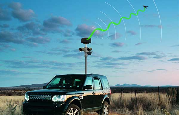
VigilAir is an RF-based system of deployed sensors able to accurately detect, geolocate and track commercial drones and their operators in different environments, including dense urban environments. VigilAir provides extremely sensitive detection and highly accurate geolocation and tracking over very large areas, with virtually zero false-alarms. Being a passive, receive-only system, VigilAir can easily be installed and operated without regulatory or legal limitations. The VigilAir version 2.0 C-UAS (counter unmanned aerial system) is certified by the United Kingdom Center for the Protection of National Infrastructure (CPNI) under the CPNI’s Counter Unmanned Aerial Systems Detect, Track and Identify (DTI) testing and evaluation standard. VigilAir generates a comprehensive drone situational awareness which enables users to proactively and intelligently match correct mitigation actions with actual drone threats, on time and with minimal collateral effects.
Xpeller Rapid — the mobile version of the counter UAV solution Xpeller — uses a combination of radar, electro-optical sensors, rangefinders and jammers to protect against threats posed by over-the-counter drones. Xpeller Rapid is either integrated into a vehicle (mast solution) or comes in transport boxes and can be easily set up on tripods. Based on the Xpeller toolkit, the components follow the detect, identify, control and act workflow, defeating hostile drones at ranges up to several kilometers. The system can locate and classify even small hobby drones at a range of several kilometers. High-resolution cameras make it possible to decide whether there is a serious threat so that it can be countered with appropriate countermeasures.
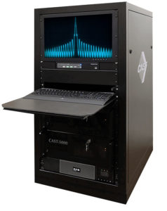
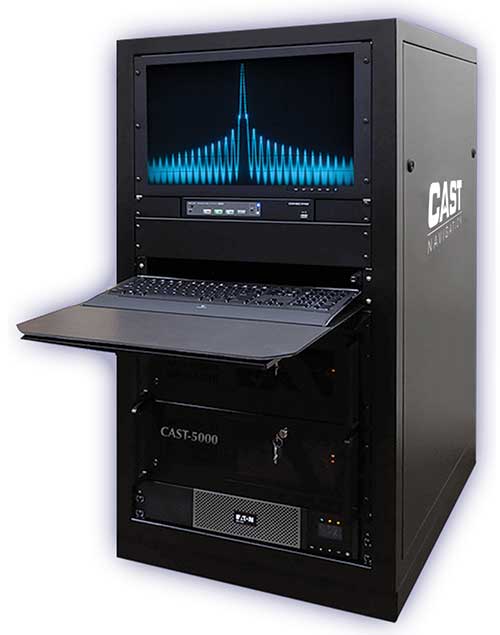
The CAST-5000 produces a coherent wavefront of GPS RF signals to provide repeatable testing in the laboratory environment or anechoic chamber. The basic system generates four independent, coherent simulations that reference a single point and is configurable to support up to eight elements for CRPA testing. With an intercard carrier-phase error of less than 1 millimeter, the CAST-5000 is extremely accurate.
The system generates a wavefront of GPS when its GPS RF generator cards are operated in a ganged configuration. Each generator card provides a set of GPS satellites coherent with the overall configuration. Several RF generator cards may be utilized together, ensuring phase coherence among the bank of signal generator cards. The CRPA antenna, antenna electronics and the GPS receiver can be tested as a unit with or without radiating signals.
The CAST-8000 is a new simulator that merges the CAST-5000 CRPA tester with a CAST-3000 EGI tester. The CAST-5000/8000 has the ability to be “ganged” together with additional CAST simulators to provide multiple vehicle and/or multiple antenna test configurations.
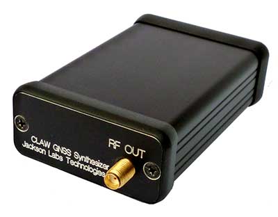
The 18-channel miniature full-constellation CLAW GPS Simulator is a fully self-contained, low size, weight, power and cost (SWaP-C) miniature GPS simulator. It is very popular in manufacturing environments as well as R&D applications that require consistent and repeatable local GNSS signals at low price points.The CLAW simulator does not require external computers for processing and control — it works fully self-contained by simply applying power, and storing location/time/date data in internal non-volatile (NV) memory, or by storing complex vector data to simulate highly dynamic scenarios. The CLAW also can be used to transcode NMEA or SCPI position/velocity/time (PVT) data into GPS RF signals. JLT offers an easy to use, highly configurable and cost-free SimCon Windows application program that is downloadable from the JLT website.
The SimConapplication allows random scenario generation and is thus usable to simulate leap-second events, week 1023 rollover events, or any other GPS live-sky scenarios including highly complex yet easy-to-create dynamic vector simulations. For authorized U.S. government users, a version that does not have altitude and velocity limitations is popular for low-Earth-orbit (LEO) simulations. Multipath simulation allows use of the entire 18-channel simulator capability. The unit can be field-upgraded with an easy to use in-field software upgrade feature. The CLAW is also very useful in GNSS receiver sensitivity testing for R&D or mass-production assembly lines as it allows accurate control of RF output power ranging from –100 dBm to less than –130 dBm with 0.1-dB resolution and typically better than 1-dB accuracy over the controllable power range.
The CLAW GPS Simulator also has a built-in RF signal generator with sweep, CW and random noise functions that are useful in simulating GNSS jamming scenarios, as well as GPS spoofing scenarios. The simulator comes in an FCC-certified metal desktop enclosure with numerous accessories.
The Orolia family of GNSS simulators offers a wide breadth and depth of tools for those responsible for mission-critical positioning, navigation and timing (PNT) applications. The simulation tools enable users to test a variety of scenarios, from simple to complex. Orolia’s simulators are feature-rich and easy to use, offering a way to harden GPS/GNSS-based systems without the limitations of testing from live-sky signals. Orolia’s approach allows users to buy only what they need today and upgrade later.
ESSENTIAL
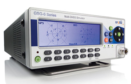
Photo: Orolia
GSG 5/6. An essential scenario-based simulator used for testing a variety of smart applications such as drones, the internet of things (IoT), connected cars, cellular and more. GSG 5/6 offers ease-of-use with an out-of-the-box configuration and comprehensive set of pre-defined scenarios, plus the ability to create scenarios. It can simulate all constellations, all frequencies, and movements/trajectories anywhere on or above Earth. This enables a multitude of test solutions covering accuracies and sensitivities due to environmental conditions, technology factors and other events. Application packages are available for real-time kinematic (RTK), eCall, high-velocity, jamming and sensors.
ADVANCED
Skydel Software Engine. The software behind Orolia’s high-end GNSS simulators: GSG-8, BroadSim, BroadSim Anechoic and BroadSim Wavefront. All share the same software-defined benefits and interoperability. In addition to Orolia’s turn-key systems, Skydel can run on the user’s own commercial off-the-shelf (COTS) hardware. It is suitable to test and validate GNSS systems for a variety of applications, with advanced signal customization and configurable outputs. Users can create advanced scenarios with multiple parameters and variables: antenna patterns, orbits, multipath, hardware-in-the-loop (HIL) and more. The easy-to-use API configures all aspects, available in Python, C#, C++ and LabVIEW. User interactions can be recorded and exported as executable Python script — a learning tool that drastically reduces the automation learning curve.
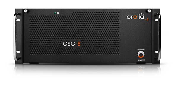
Photo: Orolia
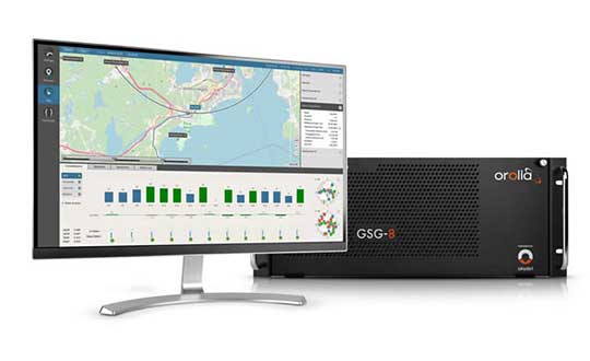
GSG-8. An advanced software-defined GNSS simulator supporting multiple constellations, frequencies and hundreds of signals all-in-view. With a 1000-Hz iteration rate, high dynamics and real-time synchronization, GSG-8 delivers ultra-high performance and flexibility. It is designed for space trajectories, custom PNT signals, HIL and more. Advanced jamming and spoofing options allow users to create benign and threat scenarios required for critical applications. Complex objects such as Differential GNSS (RTK), multi-antenna vehicles, attitude measurements and sophisticated GNSS receivers can be tested. A comprehensive software development kit (SDK) allows users to incorporate encrypted or proprietary signals. Powered by the Skydel Simulation Engine.
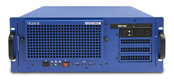
Photo: Orolia
BroadSim. Available through Orolia Defense & Security, BroadSim was designed to meet the demand of NAVWAR testing. BroadSim supports high dynamics, advanced jamming and spoofing simulation tools, and encrypted military codes including Y-code, M-AES and M-MNSA. BroadSim uses a custom Linux operating system for security and better performance. BroadSim excels in NAVWAR applications due to its four independent RF outputs, a wide dynamic range with up to 0 dBm transmit power, and integrated jamming and spoofing scenario creation. BroadSim’s ease-of-use and functionality to configure multiple vehicles allows any user to seamlessly test the performance and vulnerability of their system without requiring a high level of expertise. Powered by the Skydel Simulation Engine.
Photo: Orolia
BroadSim Anechoic. Available through Orolia Defense & Security, BroadSim Anechoic enables users to accurately simulate over-the-air (OTA) GNSS environments in their anechoic chamber. Designed from the ground up for the user, by users, the system has 32 individual RF outputs enabling it to drive 16 dual-frequency antennas. The automation of antenna mapping, time delay and power loss calibration cuts set-up time from days to minutes. Easily verify signals with a built-in spectrum analyzer. The 48-dB transmit chain amplifier and 80-dB transmit chain dial attenuator allow for complete signal control and high dynamic range. Powered by the Skydel Simulation Engine.
Photo: Orolia
BroadSim Wavefront. Available through Orolia Defense & Security, BroadSim Wavefront enables fully featured testing of controlled reception pattern antenna (CRPA) and multi-element antenna electronic systems. Scaled upon the same easy-to-use software-defined platform and interface, it supports 4-16 antenna elements with integrated high dynamics and a phase coherence of 1° σ. Users can simultaneously simulate multiple spoofers, jammers, repeaters and alternate PNT sensors with just a few clicks. The Wavefront makes no compromise between the number of signals and the iteration rate, which remains at 1,000 Hz. It is designed to help engineers deliver results and make decisions, and can be calibrated in a matter of minutes. Powered by the Skydel Simulation Engine.
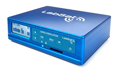
The LabSat 3 Wideband is a compact yet powerful multi-constellation and multi-frequency GNSS testing solution.
The easy-to-use, one-touch record and replay function provides an efficient way to test and develop GNSS-based technology without the cost and limitations of live-sky signals.
With simple-to-install upgrade options available, customers can invest with the confidence that its capabilities can grow alongside their future requirements.
LabSat 3 Wideband can record and replay up to three different channels at 56-MHz bandwidth across all major constellations and signals including:
GPS: L1/L2/L5
GLONASS: L1/L2/L3
BeiDou: B1/B2/B3
QZSS: L1/L2/L5
Galileo: E1/E1a/E5a/E5b/E6
L-band correction services including SBAS and IRNSS
2x CAN, RS232 and digital inputs tightly synchronized with GNSS data
Future signal launches are also supported, including L2C, L5 and L1C
LabSat 3 Wideband has a removable SSD (up to 7TB) and a two-hour runtime provided by an internal battery. It is lightweight and portable, making it ideal for field testing in any environment.
SatGen Signal Simulation Software
SatGen software allows users to quickly create bespoke, accurate scenarios with their own time, location and trajectory, that can be replayed via a LabSat GNSS Simulator.
The latest version of SatGen can be used to create a single scenario containing all the upper and lower L-Band signals for GPS, Galileo, GLONASS and BeiDou.
Precision-sensitive applications such as autonomous driving, control of unmanned aerial vehicles (UAV), or positioning of aircraft during landing procedures in coordination with ground-based augmentation systems (GBAS) require that modern GNSS receivers undergo detailed tests before implementation.
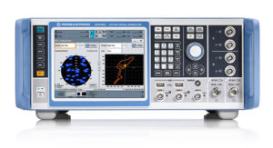
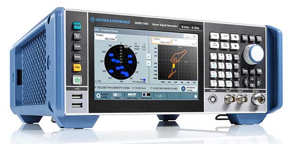
Rohde & Schwarz signal generators like the R&S SMW200A and the R&S SMBV100B offer a unique approach to generating complex and highly realistic scenarios for testing of GNSS receivers that are able to work with diverse navigational systems such as GPS, GLONASS, Galileo, BeiDou and QZSS/SBAS signals. Both simulators can emulate them all for testing.
R&S SMW200A. The R&S SMW200A GNSS simulator (pictured above) can be used to produce complex interference scenarios with multiple interferers — all generated within the instrument itself. It can emulate up to 144 GNSS channels and can be equipped with up to four RF outputs. With its ability to simulate multi-constellation, multi-frequency, multi-antenna and multi-vehicle scenarios, the R&S SMW200A is able to cover a variety of high-end GNSS applications.
R&S SMBV100B. The R&S SMBV100B supports the same navigational systems, with access to 60 GNSS channels and one RF output, with the same ability to configure realistic scenarios including obscuration, multipath and atmospheric effects, as well as the specific characteristics of the antenna and the simulated vehicle. An integrated noise and CW interference generator also can be added.
Since the devices do not require an external PC for scenario configuration, all the tests can be created quickly through the user-friendly GUI. Due to all-encompassing instrument options available, both simulators can be set up to fit unique user requirements.
For testing GNSS receivers under controlled and repeatable conditions, the R&S SMW200A and the R&S SMBV100B provide extensive and cost-effective solutions. The platforms are ready to adapt to future requirements and testing of newly implemented GNSS signals.
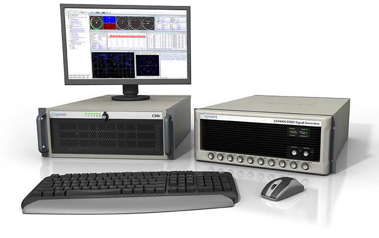
GSS9000, SimMNSA, CRPA test system, anechoic chamber testing, mid-range testing
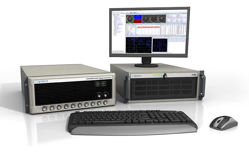
Photo: Spirent Federal
Spirent Federal provides GPS/GNSS test equipment that covers all applications, including research and development, integration/verification and production testing.
GSS9000. The enhanced GSS9000 Multi-Frequency, Multi-GNSS RF Constellation Simulator is Spirent’s most comprehensive simulation solution. It can simulate signals from all GNSS and regional navigation systems and has a system iteration rate (SIR) of 1000 Hz (1 ms), enabling higher dynamic simulations with more accuracy and fidelity. The GSS9000 supports restricted/classified signals. Users can evaluate the resilience of navigation systems to interference and spoofing attacks, and have the flexibility to reconfigure constellations, channels, and frequencies between test runs or test cases.
SimMNSA. The first fully approved MNSA M-code simulator. Authorized users of the GSS9000 series of simulators will be able to utilize the advanced capabilities of SimMNSA to create more robust solutions for their customers. SimMNSA has been granted Security Approval by the Global Positioning System Directorate.
CRPA Test System. Spirent’s Controlled Reception Pattern Antenna (CRPA) Test System generates both GNSS and interference signals. Users can control multiple antenna elements. Null-steering and space/time adaptive CRPA testing are both supported by this comprehensive approach.
Anechoic Chamber Testing. Spirent’s GSS9790 Multi-Output, Multi-GNSS RF Constellation Wave-Front Simulator System is a development of the GSS9000. The GSS9790 is a unique solution providing the core element for GNSS applications that require a test system that can be used in both conducted (lab) and radiated (chamber) conditions.
Mid-Range Solutions. Spirent also offers solutions that cater to intermediate GPS/GNSS testing needs. The GSS7000 multi-constellation simulator provides an easy-to-use solution for GNSS testing that can grow with users’ requirements. The GSS6450 RF record and playback system enables replay of a real-world GNSS/GPS test repeatedly in the lab.
High-end GNSS simulation solutions for R&D, integration and production testing
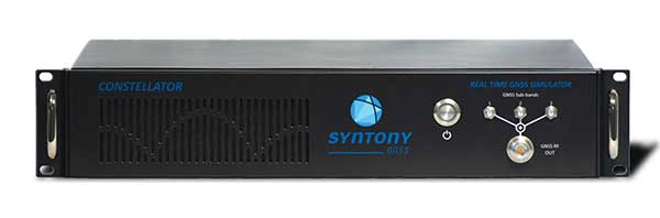
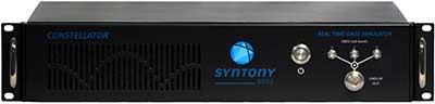
Photo: Syntony GNSS
Constellator. Syntony’s GNSS simulator Constellator supports all constellation signals available and provides a high level of service in different ranges. It covers, in a single unit, a wide spectrum of use cases from entry-level with L1C/A up to very demanding configurations such as multi-frequencies and 400 channels management.
Extensively used in aeronautics, space and defense industries, Constellator answers complex requirements:
Standalone mode (on the ground and in space)
Multi-frequencies
All constellations and their signals, including NavIC/IRNSS
Hardware in-the-loop (HIL) mode with zero-effective latency and 1000-Hz update rate
All typical synchronization interfaces
Particularly in the space industry, Constellator implements the advanced models (Earth gravity, drag, 3D ionospheric models, side lobes, etc.) needed to achieve accurate simulations for all kinds of orbits (from LEO to GEO and SSTO). Combined with other Syntony GNSS simulation products (interference generator, Recorder & Player Echo, GBAS simulator, etc.), Constellator can be used to tackle challenging use cases such as jamming, spoofing, multipath, and multiple antennas testing. Constellator is based on a software-defined radio (SDR), making it hardware-ready for future constellations, signals and codes. It is easily upgradeable and versatile.
GNSS Recorder & Player. Syntony’s Echo is an ultra-high-fidelity GNSS recording and playback solution. It is designed to capture real-life signals and environments, for instance from airplanes, and then replayed for R&D or production tests. Echo offers:
3 RF channels of 100-MHz bandwidth each (for the whole set of GNSS signals from all constellations)
16-bit resolution (I&Q)
from 7 to more than 1,000 hours of record/replay capabilities depending on configuration
Echo-R can also record complex and very long realistic scenarios from a simulator; Echo-P can replay them with very high fidelity for long-run or production tests. Please ask Chief Sales Officer Francois Goudenove for distributor contacts in the U.S., Europe, India, China, South Korea and Japan.
The new line of Sarbe search and rescue beacons. (Photo: Orolia)
Orolia is introducing the Sarbe Evo line at the Singapore Air Show, taking place Feb. 11-16 at the Changi Exhibition Centre. The line is being exhibited at Orolia’s Booth G10.
The search-and-rescue (SAR) beacon range has been improved to deliver upgraded operational capabilities, to meet the latest Cospas-Sarsat testability and maintenance requirements.
Part of Orolia since 2011, the Sarbe brand is a worldwide market leader for military (tri-forces) Personal Locator Beacons and Emergency Locator Transmitters. Sarbe beacons have been at the forefront of innovation in life saving Locator Beacons and critical communications for over fifty years.
Sarbe equipment is often integrated into air crew clothing such as Air Crew Life Preservers, ejection seats and survival packs, and can be optionally equipped with remote antennas and automatic activation.
The Sarbe Evo line offers new operational improvements in order to meet revised Cospas-Sarsat requirements in operating lifetime, location accuracy, voice signals management, integrated protocols, testability and maintenance.
Orolia’s development of the Sarbe Evo line has focused on the following key elements to improve customer safety:
Upgraded battery management with use-monitoring
Exceeds Cospas-Sarsat endurance requirements
Built-in-test further enhanced
More robust and frequent GPS/GNSS position acquisition with GPS, Galileo and GLONASS satellite constellations
Audio system improvement for greater clarity under all operating conditions
Introduction of the National Location Protocol
Rugged and reliability improvement (qualified to MIL-STD-810G standards) to support complex rescue missions in harsh environments
For both commercial and military needs in SAR operations, Orolia’s main goal remains the provision of highly accurate location data, and real-time voice and data communication to SAR operators through robust line of sight transmission.
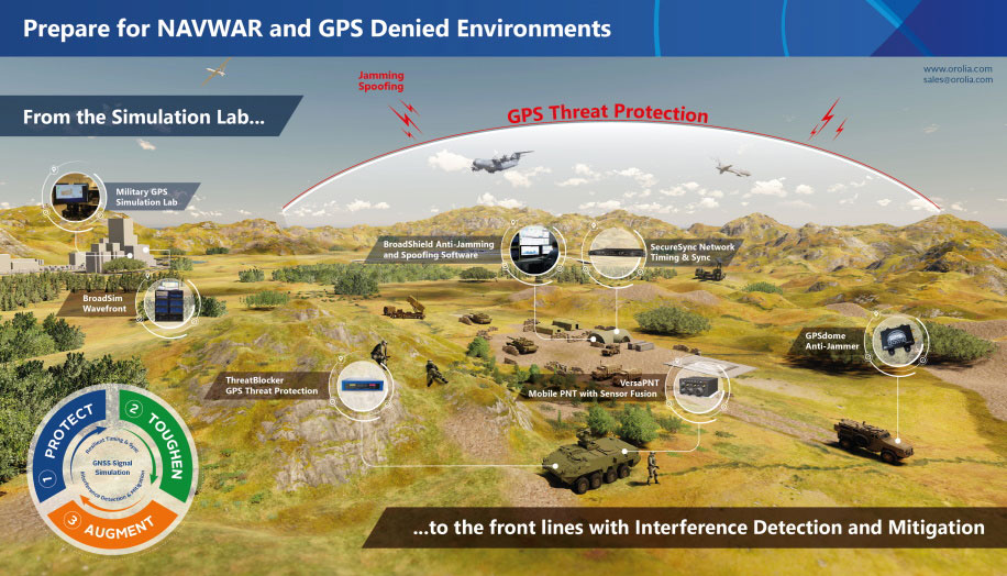
In 2019, military forces witnessed the global threat of GPS/GNSS interference grow, with more sophisticated threats and increasing military demand for assured operations in Navigation Warfare (NAVWAR) and GPS-denied environments.
Enemy forces are deploying more advanced jamming and spoofing technologies worldwide, jeopardizing the security and reliability of positioning, navigation and timing (PNT) data that feeds into GPS receivers, downstream networks and subsystems.
Military forces must vigilantly protect their information advantage from malicious attacks by delivering situational awareness, mission planning and warfighter solutions.
For these priorities, proven and efficient signal integrity solutions will be even more critical in 2020.
Requirements to Ensure Signal Integrity in 2020
Any critical system that relies on PNT data should go into the field with two known states:
First, it should withstand a GPS outage during testing and simulation — including rigorous jamming and spoofing simulation to predict how the system will react under various conditions. Simulation scenarios can vary in complexity, and newer software-defined simulators provide flexibility to meet current requirements while future-proofing investments in test equipment.
Second, the system should have a signal threat detection and alert mechanism. Critical systems also need backup layers such as anti-jam antennas, threat mitigation technology and alternative encrypted signals to ensure continuous operations, even in compromised environments.
Going into 2020, GNSS simulation and interference detection and mitigation (IDM) will continue to adapt to emerging threats and provide the essential foundation for Assured PNT.
For more about Resilient PNT and NAVWAR solutions, visit www.Orolia.com.
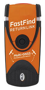
Orolia Maritime has revealed the FastFind ReturnLink PLB with Return Link System (RLS) life-saving beacon system.
Orolia worked closely with the European GNSS Agency (GSA) on the Galileo satellite system since the company was selected to lead development of next-generation search-and-rescue (SAR) distress beacons. Earlier this year, Orolia introduced the first Galileo-enabled personal locator beacons (PLBs).
Building upon this, the new FastFind ReturnLink transmits the user’s unique ID and GNSS location via the global network of Cospas-Sarsat search-and-rescue satellites, and then uses Galileo’s Return Link Service to transmit a return signal back to the user’s device to confirm the alert has been received and location has been detected.
The PLB displays a blue light to inform the user that search-and-rescue professionals are aware of their situation and location and that they are not alone.
“We are dedicated to producing SAR products that keep people safe on land and sea, and the FastFind ReturnLink PLB is Orolia Maritime’s most advanced search and rescue beacon to date,” said Chris Loizou, vice president of Maritime at Orolia. “The psychological impact of knowing that help is on the way cannot be underestimated, and this PLB will provide invaluable peace of mind for those in distress.”
The FastFind ReturnLink PLB uses the latest SAR technology, packed into a simple, rugged and lightweight palm-sized unit. Features include:
Multi-constellation GNSS — both Galileo and GPS receivers.
Belt-attachable buoyancy pouch and life-jacket oral tube clip attachments.
No subscription.
Five-year battery life.
Waterproof to 10 meters.
SOS Morse LED flashing light and RLS Reassurance blue flashing light.
Safe-stow antenna and three-stage activation.
Galileo’s RLS is expected to be fully operational in January 2020.
Resilient positioning, navigation and timing (PNT) company Orolia has nearly tripled new U.S. military orders for specialized resilient PNT solutions in the third quarter of 2019, the company stated in a press release.
Orolia said its solutions are helping to meet growing military demand for assured operations in Navigation Warfare (NAVWAR) and GPS-denied environments.
In the third quarter, Orolia unveiled its new Simulation and Interference, Detection & Mitigation (IDM) suite, announced the acquisition of GNSS simulation company Talen-X and introduced new advanced GNSS jamming and spoofing countermeasures.
The new U.S. military orders include the full range of Orolia’s resilient PNT solutions.
“This rapid industry response affirms Orolia’s commitment to delivering trusted military solutions for GPS denied environments,” said Paul Zweers, Orolia vice president of sales and marketing.
This tongue-in-cheek photo, courtesy of Racelogic, underlines how simulators help GNSS engineers “road test” multiple positioning products in multiple scenarios. (Photo: Racelogic)
The number of GNSS signals, the frequency and sophistication of intentional and unintentional threats to those signals, and the need for integration between GNSS and other positioning, navigation and timing (PNT) sources — especially for indoor and autonomous navigation — are continuing to increase, as is the number of new applications for GNSS. In response, manufacturers of GNSS simulators are creating new and improved models able to simulate all these new signals and scenarios.
Additionally, as GNSS chipsets continue to be further commoditized, simulator manufacturers must address the needs of new entrants into the GNSS receiver market that have lower accuracy requirements and require less technical expertise and, therefore, require units that are smaller and cheaper and have simpler interfaces.
No single manufacturer can address the full spectrum of challenges that these trends present. So, while their products overlap in capabilities and SWaP-C (size, weight, power and cost), each one has chosen its market niche and preferred mix of features.
Even on the deceptively simple question of definition (“What is a GNSS simulator?”), the seven manufacturers featured here give different answers, covering the following capabilities:
Simulating GNSS signals as well as inertial navigation data.
Enabling users to test hardware, software and new solutions in the lab before deployment.
Enabling users to test systems under pristine or extreme conditions, including error conditions.
Enabling users to test systems during rare, transitional and prohibited events.
Helping to retrofit existing equipment to new and emerging standards.
Innovations being introduced or developed include:
an anechoic simulator to test continuous radiation pattern antennas (CRPAs).
simulation of a full M-code modernized signal.
software-defined simulators.
increased automation of repetitive tasks.
the capability to record and replay real-world signals.
the capability to record and synchronize data on the conditions faced by a test vehicle.
While the universe of GNSS satellites and receivers continues to grow and evolve, the universe of GNSS simulators is keeping pace — or even a step ahead.
Click on the company to be directed to that section.
John F. Clark, Vice President, Engineering. (Photo: CAST Navigation)
In the lab, simulators allow users to “drive” a piece of equipment through 3D space, performing flight testing or checking equipment integration. Simulators also validate operational flight programs (OFPs) for pilots before they are fielded, to ensure that the software is working correctly.
Innovation. CAST’s latest simulator is the CAST 5000 wavefront generator. It allows users to drive GNSS and interference signals that represent a continuous radiation pattern antenna (CRPA), which consists of multiple, smaller antennas all combined into one unit. In real life, each one of those antenna elements is in a different location; therefore, when they receive signals from a jammer or any of the GNSS satellites, each one will see that signal in a slightly different phase from the other elements. “Our simulator allows us to present signals to these antennas that model the same type of phase differentiation that you see in real life,” Clark said.
Photo: CAST Navigation
Coming Next. CAST Navigation is constantly improving its software based on user feedback. “We are in the process of enhancing our user interface to make it much more powerful but also much simpler to use,” Clark said. Hardware is also being improved, with implementation of the latest available GNSS always on the list.
Looking Ahead to 2022. Jamming and spoofing are becoming more prevalent, not just for the military but also for consumers. Consumers are starting to encounter more instances of jamming, denying their phone the ability to track a GPS satellite or transmitting incorrect GPS data so the solution that their device gives them is not correct. “Our focus is on products and capabilities that help our customers simulate those types of environments and mitigate those kinds of reactions,” Clark said.
Jackson Labs Technologies Inc.
Said Jackson, President and CTO. (Photo: Jackson Labs)
Jackson Labs’ simulators take a position, navigation or timing signal, re-encode it into an RF signal through a GPS simulation procedure, and output a real-time RF signal that encodes the position, navigation and timing (PNT) information, within milliseconds, into an RF signal that can be fed into existing equipment. “We came up with a general-purpose simulator that is basically a no-frills, low-cost, highly accurate, highly stable, highly reliable, extremely small GPS-only simulator,” explained Jackson. “We only provide GPS L1 simulation, to keep the cost of the product down, because GPS L1 C/A code is the only code required to generate an accurate and assured PNT fix, and because we are looking at simulating to embedded systems, where you only need an L1 C/A code simulator.”
Photo: Jackson Labs
Coming Next. Jackson Labs’ simulators don’t require an external computer for data processing or control. That makes it possible for companies like Toyota to plug the unit into a car on the assembly line, and generate RF output that is fed into their GPS-based navigation systems to pass final quality-assurance checks on the production line. Jackson Labs expects to further reduce SWaP-C (size, weight, power and cost) requirements and potentially add other signals. “We are also looking to potentially combine our simulators with other product lines that we have, such as our comprehensive atomic clock product line,” Jackson said.
Looking Ahead to 2022. Jackson predicts that the sector will split into two paths: an industrial sector with units for manufacturing and deployment, and companies that introduce emerging GNSS systems at much lower price points, smaller SWaP, and with more modular deployment. Inertial navigation systems (INS) are critical for autonomous driving and assured capabilities during spoofing and jamming events, Jackson said. “It is not possible today to very easily simulate INS units.There is a market for innovation in terms of integrating what the military calls ‘assured PNT,’ which includes things like dual navigation.”
Orolia
Stéphane Hamel, Director, Testing and Simulation. (Photo: Orolia)
According to Orolia’s Hamel, a simulator’s purpose is two-fold: first, it must reproduce threats and second, it must prove the solution is working.
Innovation. When Skydel Solutions joined Orolia in March, it brought a professional software-defined simulator that makes possible fast prototyping and development cycles. It integrates advanced interference simulation and can simulate hundreds of threats simultaneously. “When you want to do a repetitive step, automation is the key,” Hamel said. “Our simulator can teach you how to automate, just by clicking on a button and generating source code.” In 2018, Skydel introduced an anechoic simulator to test Controlled reception pattern antennas (CRPAs). Also new is a waveform simulator, so CRPA units can be tested in a conducted (rather than radiated) way.
Image: Orolia
Coming Next. In the next three years, Orolia is looking at adding Galileo PRS, GPS M-code, or the next-generation signal. “Being software-defined means that we are very flexible and we can allow our partners to develop their own plug-ins,” Hamel said. “They can build custom signals, restricted or modernized signals. Our simulator will take care of the dynamics of the signal and our partners can focus on the characteristics of the signal, or the things that are secret, classified, or if they simply want to protect their IP.”
Looking Ahead to 2022. Resilience to serious spoofing and jamming threats is high on Orolia’s list, as well as ensuring secure or valid positioning, navigation and timing (PNT) in GPS-denied environments. Alternative signals, sensors and increased complexity require a simulator to address all of these. Companies that develop complex proprietary hardware platforms will be challenged to keep up with the increasing complexity. and a software-defined approach will be an advantage.
Racelogic’s first LabSat was a recorder with player — the signals were recorded outside, and then replayed in the lab. Racelogic’s simulators now also provide simulation of the signals using software to generate the signals as though they are being sent by the satellites.
Innovation. In 2018, Racelogic introduced the LabSat wideband, which uses the company’s SatGen software. It records at 56 MHz and up to 6 bits of resolution and streams the data to an internal SSD hard drive. It can also replay real-world simulations or ones generated with SatGen. For the automotive world, it records and replays signals such as CAN, RS232, RS485, IMU and other data channels, synchronizing them at the same time. VBOX allows users to record and replay video with the perfectly synchronized recording made on the LabSat. “You see exactly the kinds of conditions of the test vehicle or person who has been subjected to the test,” Thomas said.
Photo: Spirent
Coming Next. Racelogic is providing wider bandwidth, greater bit depth, and multiple channels in a small battery-powered device that records even more signals, including lidar, EtherCAT (an automotive Ethernet format) and CAN-FD (a faster version of the CAN format). It will be able to synchronize with multiple video cameras instead of just one in high resolution. “It is basically the same as what we are selling, but on steroids, and at a very similar price point,” Thomas said.
Looking Ahead to 2022. With multi-GNSS going mainstream, both chip manufacturers and simulator manufacturers will be challenged by the cost of test equipment. Chip makers need to be able to test the new signals on their production lines, while simulator makers will need to provide devices at a price point and ease of use for customers with less stringent or slightly less technical requirements. “They need a simpler interface and a smaller, cheaper unit,” Thomas said.
Rohde & Schwarz
Markus Irsigler, Product Manager, Signal Generators. (Photo: Rohde & Schwarz)
An increasing number of GNSS applications depend on multi-frequency GNSS.
Innovation. In response, Rohde & Schwarz added multi-frequency test capabilities to its entry-level and mid-range test solutions. “We have launched a new GNSS simulator based on the new mid-range vector signal generator R&S SMBV100B,” Irsigler said. A simple and flexible option concept allows users to turn the instrument into a full-featured and powerful GNSS signal source. It addresses a wide range of test applications, from single- and multi-frequency production testing to multi-frequency receiver characterization. The instrument can be equipped with an internal noise generator that allows users to simulate GNSS plus noise or CW interference without using additional external hardware.
Photo: Rohde & Schwarz
Coming Next. GNSS test solutions from R&S are based on general-purpose vector signal generators. With this approach, GNSS and other signals can be generated at the same time in the same instrument allowing coexistence and interference testing without additional external signal sources. As this results in test solutions that are compact and very flexible to use, R&S will continue to use this approach for upcoming product upgrades and enhancements as well as for its next generation of GNSS test solutions. The company’s upcoming activities will mainly focus on the high-end segment, where the R&S SMW200A with up to 4 RF outputs and up to 144 channels addresses multi-antenna and multi-vehicle GNSS test applications.
Looking Ahead to 2022. With the safety demands of autonomous driving or aircraft landing procedures, multi-frequency testing will become standard. Because such applications must be sufficiently robust against spoofing and jamming threats, there will be an increasing need to test navigation systems against such influences. “Simulating GNSS alone is not enough,” Irsigler said. “Test solutions for autonomous driving will require several other techniques and signals to be applied or simulated, such as RTK/PPP or outputs from other vehicle sensors to perform sensor fusion.”
Spirent Federal Systems
Roger Hart, Director of Engineering. (Photo: Spirent)
Spirent’s simulators test with “real-world” signals as well as allowing tests under pristine conditions or under extreme conditions that may never occur in the real world, including error conditions.
Innovation. In December 2018, Spirent released the SimMNSA, which provides a full M-code modernized signal solution. Until now, the GPS Directorate limited M-code simulation to either pseudo-M-code, which provides the same spread-spectrum but uses a commercial encryption standard, or a system of playing back a canned set of M-code limited to certain satellites and dates and times. With the policy change, Spirent can now implement M-code based on the modernized Navstar security algorithm (MNSA), and now offers both an M-code solution with the SimMNSA and a full Y-code with the SimSAAS.
Jeff Martin, Director of Sales. (Photo: Spirent)
Coming Next. Spirent plans to provide customers an increased channel count to help test multi-constellation, multi-frequency receivers against multipath, jamming and spoofing. “We are in a period of intense development in terms of AVs, UAVs, and so forth, which don’t use GNSS exclusively,” Hart said, explaining that Spirent is working on testing of GNSS/sensor-fusion platforms.
Looking Ahead to 2022. “As new interface specifications are released, we are proactive in developing new signals,” Hart said. Spirent also is supporting efforts to achieve assured PNT solutions. It is investigating interference-mitigation techniques such as algorithms, directional antennas, and other anti-jam technologies. Signal authentication is another need. “As the systems are becoming more integrated and networked, we are conscious of cyber-security threats and are looking in that area,” Hart said.
Photo: Spirent
Syntony GNSS
Cyrille Gernot, GNSS Receiver Development and Product Manager. (Photo: Syntony GNSS)
GNSS receiver manufacturers use simulators to ensure that their products are robust in challenging situations that can’t be clearly assessed using real-world data. “That’s where the GNSS simulator comes into play,” Gernot said, “by offering controlled and repeatable scenarios.”
Innovation. Syntony’s new pseudo-random-noise code (PRN code) server allows the GNSS simulator user to dynamically send the pseudo-random sequence modulating a carrier. It is especially useful for testing encrypted signals such as the GPS military signal or the IRNSS RS signal. “Access to encryption keys is extremely difficult for a simulator manufacturer to obtain,” Gernot said. “However, the simulator does not actually need to have knowledge of those encryption keys; only the resulting pseudo-random sequence to modulate is required.” The Syntony PRN server allows users to dynamically input their own pseudo-random sequences to be modulated on the target carrier into the simulator.
Coming Next. Syntony’s next simulator will simulate spoofing and synchronous multi-antenna signals for CRPA and antenna network testing.
Photo: Syntony GNSS
Looking Ahead to 2022. As the threat of spoofing and jamming increases, the receiver industry will have to develop countermeasures and mitigation strategies. One of the best methods remains the use of antenna arrays, Gernot said. “Antenna arrays allow for spatial discrimination that is especially efficient to counter spoofing, jamming or unintentional interferences.To meet the industry’s future demands, Syntony is already working on accurate simulation of antenna arrays while accounting for inherent errors such as inter-antenna phase and amplitude offsets and overcoming obstacles, including phase coherency at the output of the simulator RF channels.”
The Official Journal of the European Union (EU) will publish a funding opportunity in the near future for a GNSS “Advanced Interference Detection and Robustness Capabilities System,” according to officials familiar with the project.
Advance notice of this procurement was first given in August of last year, with an award projected for the first quarter of 2019. Some observers have speculated that the procurement delay was related to a change in how the final system is envisioned. The current version of the notice asks for a crowdsourcing, software and networked-based solution.
The advance notice calls for the vendor to both establish the system and operate it.
The purpose of the present tender is to establish a new mechanism to detect interference at receiver and antenna level based on crowdsourcing and sharing information coming from any user (individuals or associated ones) and run the service for a period of two years.
While for many “crowdsourcing” suggests the participation of large numbers of individuals, this will likely not be part of the scheme. Speaking to a government advisory board, Jean Yves Courtois, CEO at Orolia, said that battery drain on cell phones would prevent this from being practical. “Privacy concerns would also be an issue,” he said. Each individual would have to affirmatively agree to have their location information used continuously. This additional administrative burden would be significant.
Much easier and preferable would be using Information from already deployed networks of fixed receivers, such as base stations. Unchanging locations and existing network connections make the engineering easier and thorny privacy concerns would be minimized. These ideas are also reflected in the current version of the advance notice:
The activity shall also focus on identifying and engaging users (such as entities currently monitoring vast networks of devices integrating GNSS receivers) by means of an appropriate enrolment scheme ensuring the provision of the data. The design of the system shall ensure that the sensitivity of the data (GNSS vulnerabilities) is always protected.
Crowdsourcing and collating such information is seen by many in industry as a relatively straight-forward engineering problem. Representatives from Orolia and Microsemi, for example, included ideas about crowdsourcing disruption data in recent presentations to the U.S. PNT Advisory Board. Both agreed, though, that there are few commercial incentives to do such work without a government customer.
It is perhaps not a surprise that the EU is taking the lead in this field while other GNSS providers seem to have little interest.
Unlike GPS, GLONASS and BeiDou, which are first and foremost national security systems, Europe’s Galileo was built and is operated by a civil organization focusing on economic and civil benefits. Interference with signals directly undercuts these benefits and can be easily seen in direct economic costs.
Many European countries are using GNSS for road tolling, for example. Small GNSS jammers are easy to acquire off the internet and their illegal use is likely costing nations millions of euros in lost tolls each year. Without the ability to regularly detect, sanction, and deter this activity financial losses will continue to mount.
The interference with tolling problem is not specifically addressed in the EU’s advance notice. It may well be that tolling authorities and others will be expected to install their own application specific interference detectors and then encouraged to link them to the EU backbone and database.
The European Commission has been aware of this vulnerability for some time. In 2015 it contracted with Nottingham Scientific Ltd. in the UK to lead a multi-nation team and assess the extent of the problem.
The STRIKE3 project was in operation from February 2016 to January 2019. Its goals were to sample and classify interference events, recommend a standard event reporting scheme, and assess the vulnerability of different types of GNSS receivers.
The project’s sampling activity in 23 different countries detected nearly 500,000 interference events. Of these, 59,000 were classified as deliberate attempts to disrupt GNSS signals.
Within the deliberate events the STRIKE3 team were able to identify about 300 jammer “families,” according to Mark Dumville, Co-Founder and Director at Nottingham Scientific. Along with the jammers they were able to classify into groups, there were “some very interesting outliers,” Dumville said. “These are likely evidence of jammer technology continuing to develop and evolve.”
STRIKE3 is viewed as a very successful project by most everyone in the international PNT community, and certainly within the EU, according to officials.
The upcoming announcement and future establishment of an on-going interference detection capability are some of the next logical steps to better securing Europe’s PNT services.
The new portfolio offers a comprehensive array of GNSS validation technology, as well as signal and PNT data protection through jamming/spoofing detection, suppression and countermeasure solutions.
The capabilities are built on Orolia’s legacy of resilient PNT solutions, together with two key acquisitions completed this year: Skydel Solutions and Talen-X. These companies were selected based on their demonstrated GNSS testing and simulation experience.
GSG-8, the latest advanced simulator from Orolia, was also introduced to the global GNSS community this week at ION GNSS+. This software-defined simulation solution offers ultra-high performance and unmatched flexibility in an easy-to-use format. GSG-8 was developed to deliver the highest standard of GNSS signal testing and sensor simulation performance, in an upgradable and scalable platform.
“With its scientific precision and advanced simulation capabilities, GSG-8 is revolutionizing the GNSS simulation industry with Orolia’s robust 1000Hz Skydel software engine and COTS software-defined radios,” said Stephane Hamel, director of testing and simulation at Orolia. “GSG-8 is designed for customers that require complex capabilities to validate product and program performance in harsh, high risk environments where failure is not an option- such as government agencies, space programs and specialized commercial programs.”
It can be programmed to simulate operations with multiple GNSS constellations and to incorporate the use of encrypted or proprietary signals. GSG-8 can also be configured for Wavefront and Anechoic chamber simulation protocols to test anti-jam antennas and complete systems, to serve the most challenging program requirements.
Talen-X has joined Orolia Defense & Security to expand its capabilities and resources, enabling the development of more advanced position, navigation and timing (PNT) solutions and to offer more robust customer support.
Orolia Defense & Security has completed the acquisition of Talen-X, a U.S. company specializing in advanced GNSS solutions and interference, detection and mitigation (IDM) technologies.
“Orolia Defense & Security is excited to bring on Talen-X as they offer a complementary portfolio of solutions and bring many years of advanced PNT experience to the team. We look forward to continuing their growth by providing additional resources and capabilities, while ensuring the growth and success of their current customers,” said Hironori Sasaki, president of Orolia Defense & Security.
In early 2019, Orolia Defense & Security spun off as a separate entity from its parent company Orolia, with the mission of providing resilient PNT solutions and custom engineering services to U.S. government agencies, U.S. defense organizations, and their contractors.
Orolia Defense & Security operates as a proxy-regulated company, free of foreign ownership, control or influence (FOCI). As such, Orolia Defense & Security is approved to work on the full spectrum of U.S. government classified and unclassified projects and is positioned to support strategic partnerships in the development of key PNT technologies for the defense market.
“Our culture of innovation, together with our demonstrated testing capabilities, will complement Orolia’s technology expertise and significantly enhance the reliability, performance and safety of military operations,” said Tim Erbes, Orolia Defense & Security’s Director of Engineering. The acquisition also enables Talen-X’s existing resources, operations and capabilities to be scaled and accelerated to better support the warfighter.
At the Modern Day Marine and Association of the U.S. Army (AUSA) exhibitions, Orolia Defense & Security is showcasing its latest technologies such as the BroadSim Wavefront GNSS simulator, ThreatBlocker jamming/spoofing detection and protection device and BroadShield threat detection software.
Authorized for use with U.S. military signals such as GPS L1/L2, P, Y, and M-Code, Orolia’s simulation and IDM solutions serve unique and challenging program requirements.
Combining data from GNSS and IMUs ensures accuracy during GNSS outages.
Leti, a research institute of France’s CEA Tech, and Orolia have announced a new sensor-data-fusion engine that ensures resilient positioning and navigation even in cases of GNSS jamming or spoofing.
Orolia is a leader in accuracy and performance for terrestrial, aeronautic and naval transportation positioning, navigation and timing applications.
Called FlexFusion, the algorithm technology processes data from GNSS, inertial management units (IMU) and odometers to provide precise positioning in all conditions.
Orolia will present its latest technological developments at ION GNSS+, booth 311, taking place in Miami, Florida, Sept. 17-19.
FlexFusion’s design relies on a modelization of GNSS and IMU (triple-axis accelerometer, triple-axis gyrometer and triple-axis magnetometer) output for synthetic trajectory generation.
The fusion approach exploits Bayesian estimators, such as Kalman filters. The first algorithm was setup on modeling signals, and its optimization relies on an extensive real-life sample database acquired through field test. This process used CEA-Leti’s HYLOC reference platform, which provides a reference positioning of a few centimeters.
More than 100 trajectory samples were collected in urban, suburban, forest and mountain environments with different GNSS outage conditions.
The new positioning technology supports edge artificial intelligence (AI) because the data-fusion algorithm is performed locally to ensure that positioning and navigation information is available locally and is failsafe even in case of jamming or spoofing of GNSS data.
“Recent events have demonstrated that it is possible to change the course of a ship or force a drone to land in a hostile area by simply spoofing GPS signals,” said CEA-Leti CEO Emmanuel Sabonnadière. “The increasing reliance on a GNSS for the execution of military operations and terrestrial, aeronautic and naval transportation requires using positioning and navigation systems that are able to detect GNSS outages and provide resilient position and navigation features.”
A version of FlexFusion that demands less of the CPU implements a loose coupling algorithm that uses GNSS receiver-output positions as entry of the algorithm. An advanced version implements a tight coupling fusion algorithm of GNSS and IMU data that significantly enhances the resilience of positioning and navigation under real-world conditions.
This novel approach enables total control of treatments and filtering applied to raw signals, which increases performance of the fusion. It also improves positioning performance in particular if there are fewer than four GNSS satellites available, or when there are recurrent multi-trajectories, which sometimes occur in urban canyons.
CEA-Leti has licensed the patented FlexFusion algorithm to Orolia.
“Orolia is integrating FlexFusion in a new version of its VersaPNT product, the first compact, all-in-one and resilient positioning, navigation and timing (PNT) system for vehicles and blue force tracking, tactical UAV navigation and marine applications,” said Thierry Delhomme, EMEA general manager, Orolia. “This powerful algorithm helps deliver on the promise of VersaPNT as an always-accurate PNT system that operates in any environment.”
FlexFusion development was supported and partially funded by the Easytech program of IRT Nanoelec, thanks to the French National Program “Programme d’Investissement d’Avenir” ANR-10-AIRT-05.
 Orolia will host an industry discussion online at 2 p.m. ET on May 7 on the Positioning, Navigation and Timing (PNT) Executive Order. Register here for the informal PNT Coffee Talk.