Tag: precise point positioning

  • Corrections Services Abound

    Corrections Services Abound

    Photo:
    While single-base real-time kinematics RTK can, under specific conditions, be the best option for certain applications in surveying and construction, corrections services typically eschew this solution in favor of network RTK, PPP, and PPP-RTK. There are, though, some agricultural networks made up of clusters of reference stations delivering RTK corrections. (Images: courtesy of Gavin Schrock and Courtney Townsend
    Bigmouse108/iStock / Getty Images/Gettu Images)

    The boom in the development of corrections services for applications such as autonomy and robotics has brought a whole new slate of market players, and an expansion of services from established corrections providers. This has benefitted high-precision users as well as the new not-so-high-precision applications.

    Whereas very high precision — centimeters — is of paramount importance to sectors such as precision agriculture, construction automation, surveying and mapping, new market sectors are less concerned with precision as they are with reliability, availability and resilience. There are many corrections services that can deliver reliable lane-level precision, decimeter precision, sub-meter or whatever the application requires.

    Corrections have been around in various forms for nearly 30 years. Whereas traditional high-precision applications would access corrections services or network infrastructure directly, the user of a mass-market application, such as assisted or autonomous driving, receives corrections second or third hand.

    A car manufacturer may install an integrated navigation and positioning system (GNSS is typically only one of many technologies in a complete system) from a vendor that receives corrections from one or more corrections services.

    A Recap of the Technology

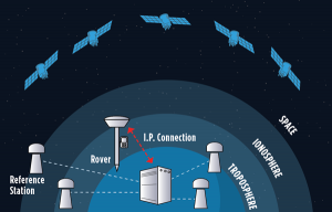
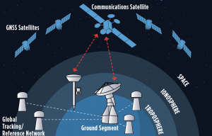
    Uncorrected GNSS is limited to precisions in meters. This may be fine for many purposes, such as coarse navigation and local-based apps. However, for high precision uses, external augmentations (commonly referred to as “corrections”) add more and higher accuracy data to help mitigate multiple sources of error that otherwise limit standalone GNSS results. Various augmented data can be delivered via radio, the internet, or communications satellites. Delivery of augmentations by public or commercial generators of this add-on data is broadly referred to as “positioning services.”

    Photo:
    Network RTK, implemented as real-time networks (RTN), covers hundreds of localities, states, and entire countries and is a go-to for many applications in surveying, mapping, construction, monitoring and agriculture. One disadvantage, compared to PPP, is reliance on terrestrial IP communications. (Images: courtesy of Gavin Schrock and Courtney Townsend
    Bigmouse108/iStock / Getty Images/Gettu Images)

    There are two fundamental approaches to generating corrections: Observation Space Representation (OSR) and State Space Representation (SSR). OSR uses observations of one or more base receivers to derive correction values representative of local conditions. Examples of OSR include base-rover real-time kinematics (RTK) and network RTK (NRTK). SSR provides “states” of conditions derived from terrestrial tracking networks, to improve clock and orbit “products,” and may also include data from global, regional, or localized ionospheric and tropospheric models. Examples of SSR include precise point positioning (PPP) solutions.

    Players in the corrections services sector include vendors who manufacture GNSS hardware, RTK systems, and NRTK software. One example is real-time networks (RTN), which have grown to cover hundreds of localities, states, regions, and even entire countries. Some of these vendors now operate their own wide region RTN. The same large vendors also have developed global PPP services. The most recent decade though has seen rapid growth in new corrections service providers that focus on one or more key markets and develop approaches specifically to serve them. For instance, many agricultural regions of the world have large clusters of RTK stations operated by a vendor or a cooperative. Some newer vendors, focused on the autonomy market, have developed global PPP services, regional NRTK, or hybrids for decimeter to meter precision. One Achilles heel of PPP is its relatively poor vertical precision compared to RTK and NRTK. This partly explains why adoption has been slow for certain high-precision applications, such as surveying.

    Where corrections services have become quite interesting, is in amalgams of these approaches. In recent years, the rapid expansion of corrections services for mass-market applications has given rise to what developers call PPP-RTK. Ostensibly, this is to take advantage of the strengths in each approach, however it may be more about trade-offs between precision and the practicalities of serving wide regions in a cost-effective manner. There are many variations on how this hybridization is achieved; for example, PPP- ambiguity resolution (PPP-AR). PPP-RTK can be somewhat of a nebulous term, much in the same way as the term “AI” gets used. Developers of the specific PPP-RTK approaches for the many corrections services keep certain details close to their chests. Clients are less concerned with how it works as they are with the results.

    Examples of Vendors

    In compiling the following list, we tried to provide examples of all aspects of the corrections service industry — from GNSS network software development to hosting of national and regional networks to providing global PPP. This segment continues to grow; new players continue to develop solutions and enter the market, some with great fanfare, while others seek to stay under the radar. This list does not include the many hundreds of RTN worldwide — local, regional, or national — though the key providers of the NRTK software these networks use are listed.

    Photo:
    One advantage of PPP and PPP-RTK over RTK and NRTK is that they can deliver augmentations by satellites, eliminating reliance on terrestrial communications networks. Satellite delivery has a downside: the number of communications satellites broadcasting the augmentations is limited, which can be problematic in sky-view challenged areas. (Image: courtesy of Gavin Schrock and Courtney Townsend
    Bigmouse108/iStock / Getty Images/Gettu Images)

    Note that other vendors are also not listed, such as some that seek to limit their visibility to specific clients and partners. For example, some offer corrections services as an adjunct to inside hardware/software sales, and others work with developers of certain integrated navigation/autonomy systems. In addition, some of the smaller vendors may be working in conjunction with some of the more established developers, often licensing elements of their software, and in many instances piggybacking on their global tracking networks.

    In alphabetical order:
    Atlas. From Hemisphere GNSS. A global PPP service delivered by L-band satellites. It includes tiered precision for different applications, such as surveying, mapping, and asset management. Atlas Basic, Atlas H30, Atlas H10: bit.ly/3V42qxj.
    CHCNAV. CPS NRTK software: bit.ly/3FI6zlN. It also hosts various RTN and has a global network partner program: bit.ly/3VQugOr.
    CNH. Advance Farming Software (AFS) RTK+ network delivering corrections mostly via cellular to primarily precision agriculture users: bit.ly/3YiCZur.
    DigiFarm. DigiFarm VBN. An example of another network that serves primarily agriculture users, however, it now has a spinoff to serve other high precision markets: bit.ly/3hgnYZs.
    eSurvey. GNSS NET, a VRS management software: bit.ly/3Py0uMp.
    Fugro. Global PPP corrections services; tiered precision for various applications, mostly maritime and marine construction. StarFix, SeaStar, MarineStar, OceanStar: bit.ly/3W4LkA8.
    Geo++. One of the first developers of GNSS network and PPP solutions. Its GNSMART software suite provides NRTK and SSR broadcast capabilities: bit.ly/3FhGE2Z. 
    HERE Technologies. HD GNSS, a PPP-RTK solution for mass-market applications: bit.ly/3Fnle4H. 
    Hi-Target. Hi-RTP, a global PPP- RTK service: bit.ly/3hi2xHv. 
    IGS. International GNSS Service, a federation of agencies and research entities with a global tracking network of more than 400 reference stations. The IGS is a vital component of the global geodetic infrastructure. RTS is its real-time PPP service. It is not fast converging like many of the commercial services, but it is free for many applications. It is not broadcast via satellites, only via the internet: igs.org.
    Leica Geosystems. Part of Hexagon. Provider of NRTK software (Spider), and host of its own RTN covering various regions around the world (SmartNet), and global PPP (SmartLink): bit.ly/3uEwHb9. 
    NovAtel. Part of Hexagon. Includes various tiers of PPP-RTK: RTK Assist, RTK Assist-Pro*, TerraStar-L, Oceanix, TerraStar-C PRO*, and TerraStar-X* (what NovAtel calls “RTK From the Sky”): bit.ly/3HzuqWh. 
    Point One. RTK correction service called Polaris, available also via partners such as Bad Elf: bit.ly/3uPJGqA.
    Premium Positioning. RTK corrections service called RTK Premium: bit.ly/3uT0xZi. 
    Rx Networks. A mix of tiered positioning approaches for location- based applications. Truepoint. io (DGNSS, PPP, PPP-RTK): bit.ly/3We1rvT. 
    SBAS (Public). Satellite-based augmentation systems, national or regional services. Like commercial PPP, SBAS corrections are mostly served via satellites. Public safety and civil aviation are the primary drivers for providing such services. For instance, in North America, the Wide Area Augmentation System (WAAS) was chartered by the Federal Aviation Administration (FAA). There are equivalent systems in Europe (EGNOS), India (GAGAN), Japan (MSAS and QZSS), Russia (SDCM), China (SNAS/BDSAS, which is still in development) and Australia and New Zealand (SouthPAN). Other systems are in development in South America and the Caribbean (SACCSA), Korea (KASS) and in Africa and the Indian Ocean (ASECNA). 
    Sino/Comnav. CDC.NET CORS software, RTN software: bit.ly/3W56hvm. 
    Swift Navigation. Skylark RTK and Skylark DGNSS services: bit.ly/3HyWVn5. 
    Tersus GNSS. Tersus Advanced Positioning (TAP), a PPP service: bit.ly/3hoZkWD. 
    Topcon. TopNet and Topnet Live. RTN Software, regional RTN, and PPP services: bit.ly/3FRRcaw. 
    Trimble. RTN software, VRS Now (regional RTN), and tiered PPP services: CenterPoint RTX, RangePoint RTX, ViewPoint RTX, and FieldPoint RTX: bit.ly/3V3bbax. 
    u-blox. PointPerfect regional PPP and PPP-RTK: bit.ly/3FPVmQo. 
    Veripos. Part of Hexagon. Tiered global PPP services, originally focused on maritime applications: Standard, Ultra, APEX: bit.ly/3BBjfsf. 
    Verizon. Telecom infrastructure-based PPP-RTK service called ThingSpace: bit.ly/3Fw1U55. 
    Vodaphone. Currently developing corrections services in conjunction with Topcon: bit.ly/3Pug4s0. 

    Whatever the application, there are now many options for corrections services. Non-mass-market applications, for traditional high- precision uses, have been tapping such services for (in some cases) decades. The prize of primacy in the autonomy market has been in the sights of many of these vendors for many years, yet there have been relatively few real-world applications to date. That should be changing soon. Early adoptions such as GM’s Super Cruise, which is powered by the same core PPP technology as RTX, have been quite successful. Which will come out on top? That might be a moot question. With the potential of such markets so great, perhaps there is room for all of them, and more. 

  • First Fix: Arrivals and Departures

    First Fix: Arrivals and Departures

    Matteo Luccio
    Matteo Luccio

    As we begin 2023, GNSS development continues apace, as described in this issue’s annual “Directions” section by representatives of Galileo, GLONASS, and BeiDou. We plan to publish a similar update on the GPS program soon.

    Galileo’s user base now stands at more than 3.5 billion, and the services it provides continue to improve and expand. Beginning early this year, free precise point positioning (PPP) corrections for Galileo and GPS (single- and multi-frequency) will improve real-time user position by up to 10 times. While the discontinuation of Soyuz launch services from the Kourou Space Centre in French Guiana, due to the Russia-Ukraine conflict, delayed the two Galileo launches that had been planned for last year, 2022 was a key year for the development of Galileo Second Generation (G2G) satellites. They will provide, among other innovations, a reconfigurable fully digital navigation payload, point-to-point connection between satellites, and advanced jamming and spoofing protection mechanisms.

    On Nov. 29, 2022, Russia launched the 51st Glonass-M satellite, about 20 years after launching the first one. Currently, 13 of these satellites are operating beyond their guaranteed lifetime, with an average orbit lifetime of more than 10 years. Starting this year, the constellation will be renewed by Glonass-K and Glonass-K2 satellites, which provide CDMA signals to users.

    Currently, 45 BDS satellites are operational in orbits, including 15 BDS-2 satellites and 30 BDS-3 satellites. The constellation says that it has reached a continuity of 99.996% and an availability of 99%, with a global positioning accuracy better than 1.5 meters horizontally and 2.5 meters vertically (95% confidence).

    Tracy Cozzens, who has been a pillar of this magazine for 17 years, is retiring this month. We will miss her journalistic acumen, dedication to clarity and style, attention to detail, and wealth of institutional knowledge. We wish her a well-deserved retirement. At the same time, we welcome aboard Maddie Saines, our new managing editor, who is near the beginning of her career.

    I am pleased to announce that Rob VanBrunt has joined GPS World’s Editorial Advisory Board. In mid-December, the board of directors of Spirent Federal Systems, a provider of PNT test solutions for the U.S. government and contractors, appointed him as the company’s president/CEO-designate, a role he will assume when the onboarding process is complete.

    VanBrunt began his career at Spirent Communications in 1990 as product developer and manager, and then held posts of increasing responsibilities, moving to director and vice president roles focused on management, strategy and mergers and acquisitions. Most recently, he was executive vice president in the Office of Business Excellence. VanBrunt has a B.S. in electrical and electronics engineering from Rutgers University.

    Spirent Communications is a global provider of automated test and assurance solutions for networks, cybersecurity and positioning. In July 2001, the company formed Spirent Federal Systems as a wholly owned subsidiary and U.S. proxy company. Spirent Federal markets and sells Spirent Communications’ products in North America. It also provides value-added features and ongoing customer support.

    On Jan. 1, I lost my beloved mother, Maristella “Mimi” Luccio. She was 87.

    Matteo Luccio | Editor-in-Chief
    [email protected]

  • Directions 2023: Galileo Offers New Services

    Directions 2023: Galileo Offers New Services

    In 2022, the Galileo GNSS continued to provide the world’s most precise satellite navigation information, to a user base that stands at more than 3.5 billion worldwide. Furthermore, provided services continue to improve and expand, with plans for high-accuracy positioning and signal authentication now reaching fruition.

    The European Union Agency for the Space Programme (EUSPA) and the European Space Agency (ESA) continue to enjoy an effective collaboration on the many development, deployment, and evolution activities of the Galileo Programme — each according to their respective responsibilities for service provision and system development with the European Commission (EC) acting as the program manager.

    Photo: Image 1 Directions 2023
    Ranging accuracy performance from January to September 2022.
    image002.Directions2023
    Positioning-related MPLS from January to October 2022.

    New Services Launched in 2022

    Excellent Performance
    Service delivery operations and maintenance of operational systems are managed by EUSPA, which supervises many contracts that carry out the day-to-day activities from dedicated control and monitoring centers throughout Europe. In 2022, Galileo timing, navigation, and SAR/Galileo services were delivered with excellent performances that continue to exceed the formal declarations for minimum performance levels (MPL), which were increased in January, both in terms of absolute accuracy and overall service availability. The entry into service of two additional satellites in May and August, have further consolidated the overall service availability to end users.

    image006.Directions2023
    Galileo FOC Batch 3 satellite under testing.

    Expansion of Service Portfolio
    The service provision teams have been able to focus on improvements to, and expansion of, the service portfolio.

    The I/NAV improvement will positively impact end users by enabling a faster time to first fix, and updates to the data validity status flags will lead to better protection of users against expired navigation data. These changes are implemented in updates of the onboard software of the satellites being rolled out across the constellation. At present, seven operational satellites have been successfully updated; the complete software upgrade campaign is planned to be completed this summer.

    Galileo’s new High Accuracy Service will provide free precise point positioning (PPP) corrections, in the Galileo E6-B data component and by terrestrial means, for Galileo and GPS (single and multi-frequency) to achieve real-time user position improved by up to 10 times. The infrastructure to support an initial service (Phase 1) is nearing completion, and the formal declaration of the service capabilities is planned for early this year.

    To provide users with a method of authenticating the received Galileo signals, especially the satellites ephemerides and the Galileo timing parameters, the new Open Service Navigation Message Authentication (OSNMA) service enables a receiver to confirm that a navigation message originated from the EU Galileo infrastructure. Many application areas are expected to benefit from this capability, including smart tachographs, telematics and logistics, UAVs, location-based services, and timing services. Having successfully demonstrated the technology behind the service in 2022, including a public observation phase, the roll-out of the Initial Service is planned to take place by the end of the year.

    A fourth Medium Earth Orbit Local User Terminal (MEOLUT) in La Réunion will extend the SAR/Galileo Forward Link Service Coverage Area over the Indian Ocean as part of the SAR/Galileo full operational capability (FOC) declaration expected in the first quarter of 2023. The Cospas-Sarsat commissioning of this new station was completed in September 2022, and operational data is already being distributed to Cospas-Sarsat.

    Reference documents for the above services can be found at the EUSPA European GNSS Service Centre website, including technical notes, interface control documents and service declaration documents.

    SAR/Galileo-related metrics from January to October 2022.
    SAR/Galileo-related metrics from January to October 2022.
    image005.Directions2023
    Extension of the SAR/Galileo Forward Link Service Coverage Area over the Indian Ocean.

    FOC Infrastructure Development Nears Completion

    Satellite Production
    The production of the third batch of Galileo FOC satellites advanced further in 2022 with the completion of the environmental tests and the system compatibility test campaigns at the European Space Agency Test Centre in Noordwijk, The Netherlands. After 10 years of successful testing, on Oct.18, 2022, the last Galileo FOC satellite (flight model number 34) left the test center to return to the premises of the satellite manufacturer, OHB Systems, in Germany. Testing of the remaining 10 satellites has confirmed that they have been correctly built and will perform well in orbit. The acceptance review of the last couple of satellites will take place this summer.
    At the beginning of 2023, the plan is to start in-orbit testing of a quasi-pilot signal on the E5 frequency using the Galileo GSAT201/202 satellites in elliptical orbit. The provision of a signal offering coarse acquisition in Galileo E5-A/GPS L5 can be a distinguishing feature for Galileo with respect to all other constellations to further improve the capability to acquire the E5 signal at low complexity. Following in-orbit testing, the strategy for roll-out of this capability will be assessed with the involvement of receiver manufacturers.

    New SAR Galileo MEOLUT Facility in Réunion island
    New SAR Galileo MEOLUT facility in Réunion island.

    Access to Space
    The discontinuation of Soyuz launch services from the Kourou Space Centre in French Guiana, because of the Russia-Ukraine conflict, has caused delays in the two Galileo launches that had been planned for 2022. The Launch 12 campaign had to be interrupted and in March 2022 the FM25 and 26 satellites were put in storage at the Kourou launch base, then returned to Europe in November.
    Ariane 6 is the baseline launcher for Galileo satellites to ensure European independent access to space. The remaining Batch 3 satellites will be launched with the Ariane 62 launcher vehicle, the two strap-on solid booster variants of Ariane 6, now undergoing the final stages of development led by prime contractor Ariane Group. Ariane 6’s maiden flight is scheduled to take place in the fourth quarter of 2023.

    Ground Segment
    An upgrade of the ground control segment, in charge of command and control of the satellite constellation, is being developed by the industrial consortium led by GMV. The upgrades will address resolution of hardware and software obsolescence including cyber security, operability improvements, and a security monitoring overlay.

    With the planned increase in the number of satellites in orbit, an additional telemetry tracking and control facility (TTCF) is being deployed in Kourou leading to seven operational TTCF stations in early 2023.

    The ground mission segment, in charge of navigation control, is undergoing a complete technological refresh, including hardware/software virtualization performed by an industrial consortium led by Thales France. This upgrade will provide additional robustness, including a system extended contingency mode resilient to outages lasting up to seven days and a new state-of-the-art cyber security monitoring system. It will also provide ranging authentication through encrypted codes on the E6-C signal component for the implementation of the Commercial Authentication Service. Global coverage will be further increased with the introduction of two Galileo sensor stations in Wallis (Pacific Ocean) and Bonaire (Caribbean Sea), for a total of 15 sites around the globe.

    image004.Directions2023
    OSNMA-related metrics from January to October 2022.

    G2G Development Started

    Galileo’s second generation (G2G) will introduce many innovative technologies to offer unprecedented precision, robustness, and flexibility.
    2022 was a key year for the evolution of G2G activities with the fast development cycles of the first batch of G2 satellites, beginning development of the associated G2G in orbit validation (IOV) ground segment and system test beds, and the consolidation of the G2G final system capabilities — including the coordination of the mission/service roadmaps with the EC, EUSPA, and the EU Member States delegates.

    image007.Directions2023
    Ariane 62 launcher.

    G2G Satellite Manufacturing
    From the satellite development point of view, the two parallel contracts to develop and manufacture each of the six G2G batch one (G2SB1) satellites are progressing in a fast development environment, with the first hardware units ready for integration and testing.
    Following the completion of preliminary design review, these two contracts (for six satellites each) are preparing for unit-level validation/testing, which will lead to the critical design review.

    These satellites will provide the following key innovations:

    • Reconfigurable fully digital navigation payload
    • Point-to-point connection between satellites by inter-satellite-link for command and control, and ranging functionalities
    • Electric propulsion for orbit-raising capabilities
    • Advanced jamming and spoofing protection mechanisms to safeguard.

    The Galileo signals will improve with:

    • On-board authentication capabilities
    • Increased ground-to-space data rate
    • Improved time reference (number of clocks and advanced clock monitoring functions).

    G2G IOV Procurements
    2022 was also the year in which two key events took place with respect to G2G in-orbit validation (IOV) ground segment and system test bed procurements:

    • Finalization of the procurement cycle, now in the final evaluation/award phase, to be kicked off in the first quarter of this year
    • Confirmation of the IOV design through different coordinated actions with the EC and EUSPA, including the G2 system preliminary design review.
    • The contracts will provide Europe with the following capabilities:
    • G2SB1 satellite launch and early orbit phase, in-orbit testing and enhanced legacy services provision
    • G2 new capabilities in-orbit validation, including prototyping and validation of all the novel technologies that can exploit the full capabilities of the G2SB1 satellites.

    Eleven contracts will be issued to manage in synchrony all the G1 and G2 assets for the coming years:

    • G2 IOV ground control segment (G2 GCS) for satellites monitoring and control
    • G2 IOV ground mission segment/secured facility (G2 GMS-GSF) for the production, dissemination and monitoring of all enhanced legacy services and the dissemination of new G2 advanced capabilities for validation
    • G2 IOV security monitoring (G2 SECMON), for the cyber/security monitoring of the system
    • G2 filling device (G2 FD), to ensure proper initialization of system assets
    • G2 system test bed (G2STB), to generate and monitor new G2 capabilities for validation of the G2G mission/services
    • G2 PRS test bed (G2PRSTB), similar to G2 system test bed but focused on advanced PRS capabilities for validation purposes
    • G2 security chain (G2SC), a test bed to ensure proper satellite-ground segment qualification before launch
    • Four system engineering support contracts (G2 SETA), where the main GNSS technical experts from different industries in Europe provide their support to ESA and EUSPA in their different fields of expertise.
    • These contracts are complemented by a significant set of system research and development and test tools, such as test user receivers and radio frequency constellation simulators.
    Photo:
    G2G batch number one (G2SB1) satellites.

    Galileo Second Generation System PDR
    The Galileo Programme is not only focusing on short-term G2G development activities, but also looking forward to the future in terms of the consolidation and definition of G2G final operation capabilities. During the second half of 2022, more than 200 public representatives from the EC, EUSPA, ESA and Member States held countless meetings in the frame of the G2G system preliminary design review, which concluded in early December 2022.

    As part of this review, the long-term implementation (G2G in orbit capability, or IOC, and final operational capability, or FOC) was reviewed and an agreement was reached on future steps. The evolution of Galileo capabilities will not only provide better services through advanced technical solutions, but will also ensure continuity of service and enhanced backward compatibility for first-generation legacy users.

    Conclusions
    The efforts of ESA and EUSPA continue with the aim of providing users continuous and stable services and evolving space and ground infrastructure to maintain Galileo competitiveness with the other global navigation satellite systems.


    For analogous updates on the other three GNSS constellations, please see:

  • Trimble and GM exceed 34 million miles in hands-free-driving

    Trimble and GM exceed 34 million miles in hands-free-driving

    More than 34 million miles have been driven with Super Cruise engaged on General Motors vehicles. (Photo: GM)
    More than 34 million miles have been driven with Super Cruise engaged on General Motors vehicles. (Photo: GM)

    General Motors and Trimble have reached more than 34 million miles of hands-free driving with Super Cruise engaged on General Motors vehicles.

    GM teamed with Trimble to develop a reliable way to maintain in-lane positioning for hands-free driving, putting safety top-of-mind.

    Trimble’s precise GPS technology enables a vehicle to maintain its lane position in a variety of environments, including inclement weather conditions (rain, snow, fog and more), which often challenges other sensors. GM’s Super Cruise, a hands-free driver assistance system, uses Trimble RTX (Real-Time eXtended) technology to deliver high-GNSS accuracy corrections since it introduced the technology in 2017 on the model year 2018 Cadillac CT6.

    “Trimble RTX has been in commercial use for more than 10 years, and in 2018 was the first precise point positioning correction service to log miles in a commercial autonomous driving system,” said Patricia Boothe, senior vice president of Autonomy, Trimble. “It works with Super Cruise to help a vehicle maintain its lane position, bringing more consumers access to a more enjoyable and convenient driving experience.”

    Standard GPS receivers can have a margin of error of up to 25 feet, which is not suitable for vehicles that require precise absolute position information to maintain lane-level positioning. Trimble’s RTX technology removes errors in GNSS satellite data broadcasts to improve location accuracy on our roadways.

    “Super Cruise is a life-changing technology, allowing customers to experience hands-free driving on compatible, mapped roads nationwide,” said Mario Maiorana, GM chief engineer, Super Cruise. “The technology is a collaborative effort internally and externally to bring this advanced driver assistance technology to life. Trimble Autonomy has been a valuable collaborator in bringing Super Cruise to our customers.”

  • GMV, FrontierSI, Ericsson and Optus prove 5G-based high-accuracy positioning

    GMV, FrontierSI, Ericsson and Optus prove 5G-based high-accuracy positioning

    Trials in Australia are proving 5G LPP can support new positioning services. (Photo: Photo: Dan Woodrow, FrontierSI)
    Trials in Australia are proving 5G LPP can support new positioning services. (Photo: Dan Woodrow, FrontierSI)

    Several companies are joining to demonstrate 5G LTE Positioning Protocol (LPP) capabilities in field trials. The trials are part of the 5G Positioning Testbed funded under the Australian 5G Innovation Initiative.

    Technology partners include GMV, FrontierSI, Ericsson and Optus, who are joining with industry demonstration partners Kondinin Group, Platfarm (a precision agriculture company) and Position Partners.

    The results achieved by the project are considered a key step forward for the use of 5G technology for high-accuracy positioning. The testbed demonstrated each of the high accuracy GNSS-based LPP working modes, including Observation Space Representation (OSR), State Space Representation (SSR), and SSR with atmospheric corrections, integrated directly with user equipment supplied by demonstration partners to examine a variety of real-world applications. The field trials demonstrated that the solution can reach centimeter-level accuracy with fast convergence times using a commercial off-the-shelf receiver and antenna hardware.

    GNSS precise positioning is the most common technology for calculating an absolute positioning solution at the user level. For uses requiring centimeter-level accuracy, it is often required to provide GNSS corrections to reduce errors.

    Distribution of GNSS corrections is based on either the broadcast of precise point positioning (PPP) corrections through GEO satellites over the L-band, or the point-to-point transmission of real-time kinematic (RTK) corrections using NTRIP through the internet.

    Both options have their drawbacks: GEO satellite broadcast requires complex ground infrastructure and can be expensive to maintain, while NTRIP distribution has poor scalability due to the point-to-point connections required for every user.

    3GPP (3rd Generation Partnership Project) — the standards organization focusing on 5G LPP — recently introduced the support of OSR corrections for RTK users in Release 15, and the support of SSR plus atmospheric corrections for PPP/PPP-RTK users in Release 16.

    Support for these two approaches to high-accuracy GNSS positioning have increased interest in 5G LPP as a potential alternative to existing correction services. Service providers and positioning consumers can now consider the use of 5G LPP as a supporting technology in the provision of new positioning services directly through mobile networks.

    The 5G Positioning Testbed has achieved end-to-end demonstrations of high-accuracy positioning solutions using GMV’s Corrections Service and Positioning Engine, delivered through the Optus 5G network using Ericsson network technology, to user equipment designed and operated by FrontierSI.

    Field trials conducted in Australia involved real-world scenarios across three areas: precision agriculture, drone operation and augmented reality.

  • Trimble adds integrity monitoring to Centerpoint RTX FAST service

    Trimble adds integrity monitoring to Centerpoint RTX FAST service

    Trimble has introduced data integrity monitoring for CenterPoint RTX Fast, its precise point positioning (PPP) correction service.

    The Trimble RTX Integrity monitoring system is an innovative, patented solution, built in direct response to client requirements for production-ready applications. It continuously validates the reliability of correction data processed by the network, which is broadcast to users in the agriculture, geospatial, construction and automotive industries, ensuring positioning data is right the first time.

    Through a two-step process, the Trimble RTX Integrity system verifies the integrity of GNSS data and filters faulty information in the network server before the data is broadcast. A secondary post-broadcast check is conducted on the entire data transmission process where additional errors may be detected and removed.

    The integrity monitoring system is fully automated and reacts in seconds to detect, isolate and block faulty data to provide even more highly accurate and reliable positioning.

    Trimble RTX Integrity is comprised of independent monitoring stations strategically positioned across RTX Fast networks in the United States, southern Canada and across Europe. These stations continuously monitor data output during multiple stages of the Trimble RTX positioning process. Any suspicious satellite data is removed during the integrity protection process and positioning is calculated using only validated data.

    Photo: Trimble
    Trimble Alloy GNSS reference receiver. (Photo: Trimble)

    Trimble Alloy GNSS reference receivers power the independent monitoring stations using redundant internet connectivity for added reliability. To date, no other positioning network offers the same level of data integrity validation across such expansive, contiguous geographies.

    Trimble RTX Integrity monitoring system was developed in accordance with Automotive Software Performance Improvement and Capability dEtermination (ASPICE) and ISO 26262 automotive safety standards, making it easy to integrate into major automotive manufacturers’ autonomous driving systems.

    Trimble RTX Integrity can also be used by Trimble’s customers in the agriculture, geospatial and construction industries to ensure correction stream integrity and reliability for applications such as machine control and high-accuracy surveying applications.

    “Trimble remains committed to exceeding expectations by providing accurate corrections to our customers to support safety-critical and other day-to-day applications,” said Patricia Boothe, SVP of autonomy, Trimble. “Implementing additional checks and balances to ensure our data is authenticated, trustworthy and accurate is of paramount importance to maintaining the integrity of our RTX network and instilling confidence with our users that the data is correct.”

  • How precise point positioning became a survey crew favorite

    How precise point positioning became a survey crew favorite

    A positioning service energizes large pipeline surveying projects, saves time, and becomes a field crew favorite

    For projects spanning large areas, a large engineering and construction firm discovered that a precise point positioning (PPP) service — Trimble’s CenterPoint RTX — could solve the challenge of receiving high-precision GNSS in remote areas.

    Atwell Group LLC is a national consulting, engineering and construction services firm with 33 offices throughout the country and more than 1,000 team members. The company delivers a broad range of strategic and creative solutions to clients in three core markets: oil and gas, power and energy, and real estate and land development.

    Atwell provides comprehensive turnkey services, including land and right-of-way support, engineering, land surveying, environmental compliance and permitting, and project and program management.

    Photo: Trimble
    Photo: Trimble

    Pipeline construction

    Atwell’s introduction to PPP and Trimble’s CenterPoint RTX took place during two large-scale linear pipeline projects within remote areas. Atwell has substantial experience with projects of this scale, but the remoteness of some of the projects’ sections was proving to be a challenge. While they could expect to rely on base or network correction methods for most projects, Atwell needed to seek other correction alternatives — and up their efficiency for the long-corridor projects.

    With the CenterPoint RTX service at hand, Atwell performed construction staking and as-built surveys for a 50-mile pipeline. The project spanned a five-month period, with an hour or more of time saved each day using the service.

    Crews noticed an additional benefit: rapid response time. On any given day, there could be project managers, right-of-way agents, or inspectors on site, asking for additional survey data.

    “Inspectors and others started to notice how fast our crews could jump from one place to another and get the shots they requested, without having to do any base setups,” said Jason Jung, project manager with Atwell.


    “The speed at which our crews can get up and running with RTX is awesome.” — Jason Jung, 3D laser scanning projects manager, Atwell


    Because of the range limits of base radios, the crews might have to do multiple setups of a conventional real-time kinematic (RTK) base each day. RTX removed this hindrance, saving the crews time by not having to use temporary RTK bases, which entails driving to base reference points, setup and teardown, and downtime from malfunctioning equipment and battery issues.

    “RTX completely freed us from the time and hassle of base setups,” Jung said. “You turn it on, and it’s ready to go before you’ve had time to take a sip of coffee. And once our crews got used to it and gained confidence in the results, they have really loved this solution.”

    Photo: Trimble
    Photo: Trimble

    Scanning a pipeline

    Atwell recently used CenterPoint RTX on a 135-mile large-diameter pipeline project that included 19 facilities along the route. Atwell provided as-built services related to the facilities using a Trimble X7 scanner.

    The data captured was used to generate spatially correct site models that included the material traceability necessary to comply with Pipeline and Hazardous Materials Safety Administration (PHMSA) regulations. Crews used RTX to georeference point clouds from the scanner to provide the accuracy needed to comply with industry regulations. Each site was referenced with permanent monuments or scribes that tied into the master control system.

    Crews also used the RTX service to establish hard checkpoints to meet Atwell’s strenuous quality-control requirements for ground targets, such as those used in UAS control work. To do the daily “in and out” check shots, they used the free BenchMap app to locate nearby survey control marks from the National Geodetic Survey database. Most checks were sub-0.08’.

    The time saved in not having to change base positions, as well as setup and breakdown, were significant time savers along this lengthy project. The precisely registered scans helped speed up PHMSA required inspections and audits, and construction change management field operations.

    A crew favorite

    Atwell’s crews use Trimble R10 receivers and Trimble Access running on TSC7 controllers, but Jung noted that they have recently upgraded to some R12i GNSS receivers, “and they are already earning their keep.” He expects to realize even more benefits from RTX coupled with the advanced multi-constellation capabilities of the Trimble ProPoint RTK engine in the R12i.

    RTX has not only become a crew favorite, it is fast becoming a go-to solution for many Atwell projects.

  • RTK From the Sky tech transforms TerraStar-C PRO service with 3-minute global convergence

    RTK From the Sky tech transforms TerraStar-C PRO service with 3-minute global convergence

    TerraStar-C PRO is the first global correction service from Hexagon to incorporate RTK From the Sky technology to achieve RTK-level accuracy in three minutes with 99.999% availability

    In late 2020, Hexagon’s Autonomy & Positioning division announced its technological breakthrough of global RTK From the Sky, demonstrating a future where instantaneous PPP and global RTK-level accuracy is possible.

    Integrating this innovation into the core of TerraStar-C PRO, NovAtel’s corrections service, is the first phase in implementing RTK From the Sky technology into the company’s diverse portfolio of correction services for users worldwide.

    As a result, TerraStar-C PRO has become the fastest global correction service to provide centimeter-level accuracy, not just in open-sky environments but also across challenging conditions created by buildings and foliage, according to Hexagon | NovAtel.

    “RTK From the Sky technology is the foundation that enables our global correction services to be world-leading across agriculture, automotive, defense, survey, marine and autonomous applications,” said Michael Ritter, Autonomy & Positioning division president and CEO. “Our dedication to research culminated in an industry-changing technology; we’ll continue that commitment by providing the best positioning experience in speed, accuracy, availability and reliability anywhere in the world.”

    TerraStar-C PRO now converges in less than three minutes by utilizing quad-band receiver and antenna technology to leverage modernized BeiDou III, GPS III and Galileo E6 signals. The resulting process generates state-of-the-art corrections for all GNSS frequencies.

    Hexagon is a consistent innovator in GNSS, as seen in its role in developing RTK and PPP solutions. With this next-generation modernization of PPP correction generation and algorithm development, the company continues this tradition in providing the highest quality and best performing global positioning experience to users with land- and air-based applications.

    “It’s been a privilege to collaborate across the division to develop RTK From the Sky technology and leverage our collective expertise in correction generation, PPP algorithms and the entire positioning ecosystem,” said Leos Mervart, head of PPP algorithm development at Hexagon’s Autonomy & Positioning division. “I’ve worked with PPP technologies since the beginning of my career and am proud to say that this is a new era of what global positioning can look like.”

    The TerraStar-C PRO improvements are accessible now through the 7.08.10 firmware release for users on OEM7700, OEM719 and OEM729 cards and their associated enclosures for land and air applications.

    Future firmware releases will include global RTK From the Sky technology throughout Hexagon’s correction service portfolios for its global client base, including precision agriculture and marine applications.

    To learn more about TerraStar correction services or to request a free 5-day trial, visit NovAtel.com/TerraStar.

  • Hexagon and Dayou partner to bring high-accuracy GNSS corrections to China

    Hexagon and Dayou partner to bring high-accuracy GNSS corrections to China

    TerraStar X corrections technology enables lane-level accuracy with under one-minute convergence for consumer and automotive-grade GNSS receivers

    Hexagon’s Autonomy & Positioning division has partnered with Chinese positioning company Dayou to bring TerraStar X technology to the Chinese market. TerraStar X provides fast precise point positioning (PPP) corrections for autonomous vehicles and has mass-market use such as in smartphones.

    The partnership enables Hexagon and Dayou to provide consistent positioning solutions globally, including North America, Europe and China, so original equipment manufacturers (OEMs) can deploy the same design worldwide.

    The GNSS corrections generated from TerraStar X technology enable lane-level accuracy with convergence in under a minute for consumer and automotive-grade GNSS receivers, supporting advanced driver-assistance systems (ADAS), autonomous applications, safety-critical applications, mobile-phone applications and more.

    TerraStar X technology delivers corrections using industry-standard formats compatible with mobile networks and enabling efficient delivery of corrections to millions of end-user devices. Through the partnership with Dayou, OEMs can now deploy the same high-accuracy solution across China as in North America and Europe, while having access to local sales, support and technical resources.

    “This partnership provides a way for global companies to leverage TerraStar X technology to bring consistent lane-level positioning around the globe,” said Sara Masterson, director of positioning services at Hexagon’s Autonomy & Positioning division. “With its hardware-agnostic design, industry-standard format and delivery of corrections, this technology opens up the possibility of precise positioning for a multitude of new mass-market applications for customers to use one software positioning solution on all platforms worldwide.”

    “Dayou is excited to be working with Hexagon in China to bring this next level of positioning technology to market,” said Han Jianxin, chief executive officer at Dayou. “High accuracy positioning used to be limited to expensive equipment and niche markets like survey and mapping. With TerraStar X technology, everyone can have the benefit of more accurate positioning, opening up new applications ranging from autonomous driving and freight to regular smartphone users moving from point A to B.”

    Test Regions Expand to China

    Using Dayou’s local infrastructure to calculate ionosphere corrections, TerraStar X technology ensures that fast convergence to lane-level and sub-meter accuracy is available when needed.

    Engineering development test areas are available around the world to support large-scale programs with functional safety requirements. With these test regions now expanded to China, the partnership with Dayou marks a significant milestone to bring Hexagon’s TerraStar X technology to a global scale.

    China Dayou PI is a Chinese company invested in by China Intelligent and Connected Vehicles (Beijing) Research Institute Co. Ltd. for high-precision positioning service and solutions based on GNSS, INS and HD map technology.

    Image: imaginima/iStock/Getty Images Plus/Getty Images
    Image: imaginima/iStock/Getty Images Plus/Getty Images
  • Innovation: Ionospheric corrections for precise point positioning

    Innovation: Ionospheric corrections for precise point positioning

    How Good Are They?

    PUB QUIZ QUESTION: Who was Jean-Baptiste Alphonse Karr? He was a 19th-century French critic, journalist and novelist. He was at one time the editor of Le Figaro, the French daily newspaper. But he is most commonly known for the quotations from his works including the aphorism plus ça change, plus c’est la même chose commonly translated as “the more things change, the more they stay the same.” But what has this to do with GNSS you might ask?

    One of the major sources of error in GNSS positioning is the ionosphere. As I have written in the Springer Handbook of GNSS, “[t]he ionosphere is that region of the Earth’s atmosphere in which ionizing radiation (principally from solar extreme ultraviolet (EUV) and x-ray emissions) cause electrons to exist in sufficient quantities to affect the propagation of radio waves. It extends from about 50 to 1000 km or more, above which we have the plasmasphere (also known as the protonosphere).” While GNSS technology has advanced over the years, Mother Nature stays pretty constant in the long term (global warming notwithstanding). And so the ionosphere is still a factor controlling the accuracy of single-frequency GNSS positioning as it has been for the past 40 years or more. The GPS navigation message includes values of the parameters of a simple ionospheric model known as the broadcast or Klobuchar model, named after its developer Jack Klobuchar. This model permits an estimate of the zenith ionospheric delay to be computed at a receiver’s location at a particular time of day and is driven by recent solar conditions as interpreted by the GPS control segment. The other GNSS use similar approaches in an attempt to reduce the positioning error of single-frequency positioning.

    But the ionosphere is also an issue for dual- or multi-frequency positioning. Yes, the ionosphere is a dispersive medium so that by linearly combining simultaneous measurements (either pseudoranges or carrier phases) on two frequencies such as the GPS L1 and L2 frequencies, an observable virtually free of ionospheric effects can be constructed and used for position determinations. And high-accuracy positioning, particularly with carrier-phase observations, is possible with a relatively short period of observations using relative or differential positioning. However, the technique of precise point positioning or PPP requires tens of minutes or more of continuous carrier-phase observations to approach an accuracy level of a few centimeters — the well-known convergence problem of PPP. Back in 2014, Simon Banville, one of my former Ph.D. students, demonstrated that ionospheric corrections could be used to reduce the convergence time of PPP to 10-cm horizontal accuracies from about 30 minutes to a few minutes. This approach has drawn the attention of the positioning industry, which is looking into several aspects of its use including questions about the level of accuracy that can be achieved depending on the state of the ionosphere, the latency of corrections supplied in real-time PPP, as well as the location and coverage of the network of stations required to determine the corrections.

    In this month’s article, researchers at Stanford University and Hexagon Positioning Intelligence team up to help answer these questions.


    By Todd Walter, Juan Blanch, Lance de Groot and Laura Norman

    Figure 1. The three station locations. (Image: Authors)
    Figure 1. The three station locations. (Image: Authors)

    Hexagon is investigating the utility of applying ionospheric corrections to decrease the overall convergence time of the precise point positioning (PPP) filter. Stanford University has conducted several analyses on the accuracy of these ionospheric corrections over the course of the past two years. Stanford has created MATLAB tools to process data from multiple days and locations as well as to investigate intervals with larger disagreements between the raw ionospheric measurements and the provided corrections. In addition, the tool can apply varying magnitudes of latency to examine its effect on correction accuracy and error bounding.

    The current study was performed using data from April 12–May 9, 2020. These days exhibit typical ionospheric behavior for a solar minimum period. Hexagon provided 1-Hz correction data for three International GNSS Service (IGS) sites to evaluate its accuracy:

    • Stanford University (IGS 4-letter identifier: STFU), 1-Hz data
    • Vandenberg Space Force Base (VNDP) in southern California, measurements at every 15 seconds
    • Priddis, Alberta, Canada (PRDS), measurements every 30 seconds.

    These sites were chosen because they tend to have high volumes of good quality data and are covered by the ionospheric correction service. 

    The provided corrections were specifically calculated for the three selected reference sites. They include corrections for both GPS and GLONASS satellites. We downloaded RINEX data for the three sites for all 28 days from IGS. FIGURE 1 shows the locations of the three sites.

    PROCESSING METHODOLOGY

    The residual errors were determined by comparing the measured ionosphere to the corrections for all satellites. These differences contain a common mode effect due to the changing inter-frequency biases that are part of the corrections. We formed double differences for all satellite pairs (within each constellation) that have measurements and corrections present at the same time. For each such pair, the continuous tracks are determined, and a constant offset for each continuous track is subtracted to obtain the final residual error. This process is illustrated in the flowchart shown in FIGURE 2 as well as in the following example. 

    Figure 2. The processing flowchart. (Image: Authors)
    Figure 2. The processing flowchart. (Image: Authors)

    FIGURE 3 shows the raw ionospheric measurements for GPS satellites with pseudorandom noise codes (PRNs) 3 and 31. The blue plus signs use the L2-frequency minus L1-frequency code-measurement difference divided by (γ–1) where γ is the square of the ratio of the L1 and L2 carrier frequencies (𝑓12/𝑓22≅1.65). The green circles are the L1 code minus the L1 carrier divided by two, and the red dots are the L1 minus L2 carrier measurement difference divided by (γ–1). The different measurements are formed to help identify erroneous measurements that might corrupt the evaluation. Fortunately, the vast majority of the measurement data is well behaved. The traces shown in Figure 3 are all self-consistent and indicative of valid measurement data. The carrier-phase difference measurements are then used in the remainder of the processing, as these have the least amount of measurement noise.

    Figure 3 Raw ionospheric measurements for GPS PRNs 03 (left) and 31 (right). (Image: Authors)
    Figure 3 Raw ionospheric measurements for GPS PRNs 03 (left) and 31 (right). (Image: Authors)

    On the left side of FIGURE 4, we present the carrier phase ionospheric delay measurements of PRNs 3 and 31 alongside their corresponding corrections. The middle section of the figure shows the differences between measured and estimated correction values for each satellite. Notice that there are common mode drifts that span ~50 centimeters for this example. The right side of Figure 4 shows the difference between the two curves in the middle portion. This double difference is the difference between these two corrected satellites for the periods of time that they are simultaneously observed by each reference station. For each continuous double-difference track (that is, it has no detected bias break), we subtract the mean value (provided that the track spans at least four minutes). We examine this residual error in meters and the normalized residual error where we divide by the root-sum-square of the provided correction 1σ values. The process begins by comparing PRNs 1 and 2, then comparing PRNs 1 and 3 and so on until PRN 31 has been compared to PRN 32. We then repeat the same process for the GLONASS PRNs.

    Figure 4. Ionospheric measurements and corrections for GPS PRNs 3 and 31 (left), differences between the measurements and corrections (middle) and double differences between the satellite pair (right). (Image: Authors)
    Figure 4. Ionospheric measurements and corrections for GPS PRNs 3 and 31 (left), differences between the measurements and corrections (middle) and double differences between the satellite pair (right). (Image: Authors)

    These values are put into histograms, and the 95%, 99.9% and 99.999% quantiles are determined for each metric. These are calculated on a daily basis across all satellite pairs as well as aggregated over multiple days and stations. By comparing different quantile behaviors, we can see whether the full distributions are close to Gaussian (well behaved) or if they have outliers that create large tail values (poorly behaved). FIGURE 5 shows the histograms of data for the Stanford University station for the first day analyzed.

    Figure 5. Histogram of double-differenced residual error at Stanford (left) and normalized error (right). (Image: Authors)
    Figure 5. Histogram of double-differenced residual error at Stanford (left) and normalized error (right). (Image: Authors)

    As can be seen, the data is very well behaved (the histograms are plotted on a semi-log scale to emphasize the performance of the tails). If the data strictly followed a Gaussian distribution, we would expect that about 95% of the values would fall within 2σ, 99.9% within 3.29σ, and 99.999% within 4.42σ where σ is the standard deviation of the distribution. Often, similar data would have much wider tails and include many outliers; however, this data has only slightly wider tails than would be expected for a Gaussian distribution. The double difference includes the noise from two sets of measurements and two different corrections. The values in the right side of Figure 5 should be divided by the square root of 2 to assess the magnitude of error affecting just one satellite. The values on the left histogram use the square root of the sum of the variances associated with the corrections, so no similar adjustment is required there.

    FIGURE 6 shows the results of evaluating the Stanford station over all 28 days. Here the 95%, 99.9%, 99.999% and maximum values are shown for each individual day. The 95% values are fairly consistent over the 28-day period, but there is more variability in the tails of these distributions. The same data was analyzed for Vandenberg and for Priddis. The errors are largest for Vandenberg, which is situated near the edge of coverage for the corrections, with a maximum value above 35 centimeters. Priddis has the smallest errors with a maximum value below 20 centimeters, likely due to good network coverage and smaller ionospheric delays nearer to the Earth’s polar regions.

    Figure 6. Ionospheric corrections accuracy quantiles for GPS and GLONASS at Stanford April 12–May 9, 2020. Ionospheric delay double-differenced residuals (left) and normalized values (right). (Image: Authors)
    Figure 6. Ionospheric corrections accuracy quantiles for GPS and GLONASS at Stanford April 12–May 9, 2020. Ionospheric delay double-differenced residuals (left) and normalized values (right). (Image: Authors)

    FIGURE 7 shows the aggregate histograms for all of the data across the three stations for the full 28 days. Note that the  84-days reference in the figure headers refers to station-days (28 × 3). The accuracy of these corrections for the vast majority of the data remains quite impressive; the 95% value indicates a 1σ accuracy of ~1 centimeters (3 centimeters/(2√2)). The higher quantiles indicate slightly larger values due to the wider tails of the distribution with the 99.9% indicating a 1σ of ~1.7 centimeters (8 centimeters/(3.29√2)) and the 99.999% indicating a 1σ of ~2.9 centimeters (18 centimeters/(4.42√2)). The provided error bounds are conservative for most of the data. For 95% they are four times larger than necessary, and for 99.9% two times larger. However, by 99.999%, they are only 10% larger than strictly necessary and are insufficient for even smaller probabilities. This highlights the larger tail behavior and that the error bounds, which are currently only a function of elevation angle, should be updated to reflect more information about the transformation of the reference measurements into the estimate of ionospheric delay. Corrections near to the edge of coverage or that make use of fewer or less accurate measurements would be expected to have larger error bounds.

    Figure 7. Ionospheric correction histograms for GPS and GLONASS at all three sites April 12–May 9, 2020. Ionospheric delay double-differenced residuals (left) and normalized values (right). (Image: Authors)
    Figure 7. Ionospheric correction histograms for GPS and GLONASS at all three sites April 12–May 9, 2020. Ionospheric delay double-differenced residuals (left) and normalized values (right). (Image: Authors)

    KLOBUCHAR CORRECTIONS

    We are currently at a solar minimum period, and the ionospheric delays are both smaller and smoother than are typically experienced during other phases of the ionospheric solar cycle. To demonstrate that the corrections are accurately following the ionospheric behavior, and that the demonstrated accuracy is not merely a reflection of an extremely smooth ionosphere, we repeated the same process using the single-frequency global ionospheric model broadcast by the GPS satellites. This model is commonly referred to as the Klobuchar model after its developer. FIGURE 8 uses the same measurement data as Figure 7, but now the corrections are replaced with the Klobuchar model from each day and the error bound is set to a constant 1 meter 1σ value. As can be seen, the error magnitude is significantly increased to values of 50–60 centimeters 1σ. Thus, the provided corrections are accurately following the ionospheric behavior to within a few centimeters, and the actual variations in the ionosphere are more than an order of magnitude larger.

    Figure 8. Klobuchar correction histograms for GPS and GLONASS at all three sites April 12–May 9, 2020. Ionospheric delay double-differenced residuals (left) and normalized values (right). (Image: Authors)
    Figure 8. Klobuchar correction histograms for GPS and GLONASS at all three sites April 12–May 9, 2020. Ionospheric delay double-differenced residuals (left) and normalized values (right). (Image: Authors)

    To examine the changes in ionospheric variability over the solar cycle, we examined four eastern stations during a significant ionospheric disturbance on Oct. 29, 2003. These stations are in Bermuda; Greenbelt, Maryland; Santiago de Cuba, Cuba; and Washington, D.C. They experienced very large ionospheric gradients during that event. FIGURE 9 shows similar data for the four stations from that day. Note that, again, the figure headers refer to station-days and the x-axis for each graph had to be expanded to include all the errors. Here the errors are between 2.8 and 7.4 meters 1σ.

    Figure 9. Klobuchar correction histograms for GPS and GLONASS at four sites on Oct. 29, 2003. Ionospheric delay double-differenced residuals (left) and normalized values (right). (Image: Authors)
    Figure 9. Klobuchar correction histograms for GPS and GLONASS at four sites on Oct. 29, 2003. Ionospheric delay double-differenced residuals (left) and normalized values (right). (Image: Authors)Ionospheric delay double-differenced residuals (left) and normalized values (right).

    EFFECTS OF LATENCY

    We are able to configure the tool to implement different levels of latency for the corrections. This is configured as a minimum age for the corrections before they can be applied to the measurements. In all cases, the maximum age of the data beyond the initial latency value was set to 30 seconds. For example, when set to 60 seconds of latency, corrections had to be at least 60 seconds old to apply to the current epoch. If no correction existed that was between 60 and 90 seconds old, then the measurement would not be corrected.

    FIGURES 10 and 11 show results for this latency study. The top row of each corresponds to 0, 30 and 60 seconds from left to right. There was surprisingly little effect for this range of latencies, most likely due to the benign ionosphere during the current solar minimum period. The accuracy quantiles increased only by less than half of a centimeter over this period. The normalized errors saw somewhat larger growth, but the sigma values are still appropriately bounding the errors. The bottom rows correspond to 120, 240 and 360 seconds of latency, from left to right. Here we begin to see more effect from latency; the residual error is doubled by 360 seconds. Between 240 and 360 seconds, the 99.999% normalized residual error exceeds 4.42, which corresponds to the expected Gaussian value. We can also see more outliers beyond 6σ.

    Figure 10. Histograms showing the double-difference residual accuracy for differing amounts of latency. (From left) Top row: 0, 30 and 60 seconds.
    Figure 10. Histograms showing the double-difference residual accuracy for differing amounts of latency. (From left) Top row: 0, 30 and 60 seconds. Bottom row: 120, 240 and 360 seconds.
    Figure 11. Histograms showing the normalized double-difference residual accuracy for differing amounts of latency. (From left) Top row: 0, 30 and 60 seconds. Bottom row: 120, 240 and 360 seconds.Bottom row: 120, 240 and 360 seconds. (Image: Authors)
    Figure 11. Histograms showing the normalized double-difference residual accuracy for differing amounts of latency. (From left) Top row: 0, 30 and 60 seconds. Bottom row: 120, 240 and 360 seconds.Bottom row: 120, 240 and 360 seconds. (Image: Authors)

    We fit the quantiles vs. the latency times and found a strong quadratic dependence. TABLE 1 shows the resulting growth rates for the overall error and the 1σ values for each quantile. For the observed level of ionospheric activity, we recommend adding an increase to the 1σ confidence value as a function of the age of the correction. We recommend an added value of 4.5 × 10⁻⁵ centimeters/second2; thus, after 200 seconds, the 1σ value should be increased by 1.8 centimeters. However, for solar maximum periods and during significant ionospheric disturbances, we feel that this error bound will need to be increased, perhaps significantly. This error-bound term should be linked to the state of the ionosphere.

    Table 1. Ionospheric correction error growth rates.
    Table 1. Ionospheric correction error growth rates.

    CONCLUSIONS

    The correction accuracy is generally quite good, with 95% daily values almost always below 4 centimeters and below 6.25 centimeters overall. There are, however, outliers that affect the daily 99.9% and 99.999% percentiles, particularly at Vandenberg, which is toward the edge of the correction coverage region. The provided error bounds are mostly conservative, but there were still some occasional outliers. These error bounds should be more than simply functions of elevation angles. They should include real-time updates on the state of the ionosphere and quality of the correction based on the input measurements.

    We evaluated the effects of latency and found that during this solar minimum period, fairly long latency times (up to 120 seconds) showed little impact on performance. It was not until more than 240 seconds that the sigma values stopped adequately bounding the tails and the overall accuracy degraded appreciably. We advocate including a quadratic term to the error bound to account for the age of the correction. During solar minimum time, we observed that this term can be quite small (4.5 × 10⁻⁵ centimeters/second2), but anticipate it needing to be significantly larger during times of ionospheric disturbance.

    ACKNOWLEDGMENT

    This article is based on the paper “Assessment of Ionospheric Correction Behavior for Use with Precise Point Positioning (PPP)” presented at the virtual 2021 International Technical Meeting of The Institute of Navigation, Jan. 25–28, 2021.  


    TODD WALTER is a research professor in the Department of Aeronautics and Astronautics at Stanford University. He received his Ph.D. in applied physics from Stanford in 1993.

    JUAN BLANCH is a senior research engineer at Stanford University, where he works on integrity monitoring algorithms for radionavigation. He received a Ph.D. in aeronautics and astronautics from Stanford in 2003.

    LANCE DE GROOT works for Hexagon Positioning Intelligence, Calgary, Alberta, Canada, in the Safety Critical Systems Group. He holds a B.Sc. and an M.Sc. in geomatics engineering from the University of Calgary.

    LAURA NORMAN works for Hexagon Positioning Intelligence in the Safety Critical Systems Group. She obtained her B.Sc. and M.Sc. in geomatics engineering from the University of Calgary.

  • Joint venture expands SBAS for business development in Africa

    Joint venture expands SBAS for business development in Africa

    A team of companies and government agencies is developing satellite services provided by ASECNA’s A-SBAS (Satellite-Based Augmentation System) for Africa and the Indian Ocean. Besides the current SBAS, the joint venture will deliver precise point positioning (PPP, through CNES and Geoflex) and danger warnings for a wide range of applications in Africa.

    Working together are the Agency for Air Navigation Safety in Africa and Madagascar (ASECNA), Nigerian Communications Satellite Ltd. (NIGCOMSAT) and Thales Alenia Space, the joint venture between Thales (67%) and Leonardo (33%). The project is backed by Geoflex, a provider of cloud services that deliver improvements to GPS/GNSS applications to achieve positioning accuracy to within 4 centimeters on land, at sea and in the air.

    The new SBAS services are expected to aid agriculture and other sectors in Africa. Here,volcanic cinder cones and farming in rich volcanic soils on the border of the Democratic Republic of Congo and Rwanda. (Photo: iStock/Getty Images Plus)
    The new SBAS services are expected to aid agriculture and other sectors in Africa. Here,volcanic cinder cones and farming in rich volcanic soils on the border of the Democratic Republic of Congo and Rwanda. (Photo: iStock/Getty Images Plus)

    Demonstrations

    The three partners successfully demonstrated the additional services on July 7 and 8 in Brazzaville, Congo, by calling on the SBAS signal they have broadcast over the Africa and Indian Ocean (AFI) region since September 2020 to provide the first SBAS open service in this part of the world via the NigComSat-1R satellite. This trial follows successful flight demonstrations this year in Lomé in January and Douala in June.

    The first demonstration of the special urgent situation warning service via satellite showed the system’s ability to broadcast a warning message via the A-SBAS signal to mobile phones, without requiring a terrestrial network. This service sends a message to the populations concerned, providing information on the type of danger and instructions to be followed.

    The second demonstration entailed the transmission of GNSS corrections based on CNES/Geoflex PPP technology and also using the A-SBAS signal. This approach showed the system’s ability to achieve positioning accuracy to within centimeters across the entire African continent.

    The new satellite service paves the way for applications in a broad range of sectors, including precision agriculture, land and maritime transport, rail safety, drone navigation, mapping and surveying. The ASECNA SBAS was developed as part of the ‘’SBAS for Africa & Indian Ocean’’ programme as a first step towards providing robust navigation services in the aviation sector.

    ASECNA’s 18 Member States are Benin, Burkina Faso, Cameroon, Central African Republic, Comoros, Congo, Côte d’Ivoire, France, Gabon, Guinea Bissau, Equatorial Guinea, Madagascar, Mali, Mauritania, Niger, Senegal, Chad and Togo.

  • Swift Navigation and KDDI partner to expand precise positioning

    Swift Navigation and KDDI partner to expand precise positioning

    Swift Navigation logoSwift Navigation is partnering with Tokyo-based KDDI Corporation, an international telecommunications company, to help bring Swift’s precise positioning technology to the Japan market. KDDI will also be a key partner in the global expansion of Skylark precise positioning service, which is now available across the continental United States and Europe in partnership with Deutsche Telekom.

    Traditionally, precision GNSS corrections were provided using real-time kinematic (RTK) techniques, requiring a high density of reference stations and with limited fault tolerance. By partnering with Swift, KDDI is able to utilize Swift’s patented wide-area corrections solution, a hybrid of precise point positioning (PPP) and RTK. The solution delivers wide-area corrections with a low density of reference stations, fast convergence and centimeter-level accuracy from a reliable service delivered via the cloud.

    The accuracy of the Skylark precise positioning service enables lane-level positioning at fast convergence times to achieve the levels of safety, reliability, integrity and availability required by autonomous, mass-market and mobile applications.

    Skylark is GNSS hardware agnostic, giving customers a choice of which GNSS sensor they use and enabling users across industries to benefit from higher accuracy by subscribing to Skylark. With the service, automotive manufacturers can achieve lane-level accuracy in the sensor suite with high levels of integrity. Delivery companies can improve operational efficiencies and cost savings with route optimization. Mobile app companies can improve analytics using accurate data to create better maps and higher performing apps. Industrial applications can automate equipment and improve efficiency with reliably accurate positioning.

    “Swift Navigation is delighted to be partnering with KDDI to expand Skylark’s precise positioning in Japan and benefit customers around the globe,” said Timothy Harris, co-founder and CEO at Swift Navigation. “KDDI has always been at the forefront of bringing innovative technological solutions to its customers, and Swift is pleased to add value to their businesses through the reliable accuracy delivered from Skylark.”

    “We believe that Swift’s high-precision positioning solution further empowers our business capabilities in mobility space and contributes to the expansion of business coverage into smart vehicles,” said Hiromichi Matsuda, executive officer, Business Exploration & Development at KDDI Corp. “The accuracy afforded from precise positioning unlocks opportunities for a multitude of businesses and industries and adds value to our customers in Japan.”