Tag: precision agriculture

  • Trimble Launches Connected Farm Dashboard

    Trimble has launched the Connected Farm dashboard, which provides one centralized location for farmers to view key information impacting their operations. With this information, farmers will be able to make better daily decisions based on the latest data. The Connected Farm dashboard is customizable and accessible via Internet-enabled devices such as desktop and notebook personal computers, smartphones and tablets, and Trimble’s new TMX-2050 display.

    Trimble TMX-2050 display.
    Trimble TMX-2050 display.

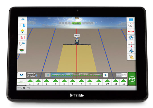
    The TMX-2050 display is a next-generation display built on the Android operating system. It offers an intuitive interface that enables farmers to easily implement precision agriculture solutions as their business grows. Its flexible software platform improves the ability for a customer to seamlessly add applications to their operations while the modular architecture allows for future expandability.

    The TMX-2050 display is an addition to Trimble’s existing line of guidance displays, which include the EZ-Guide 250 lightbar guidance system, CFX-750 display, and FmX integrated display.

    The Connected Farm dashboard will allow farmers to:

    • Check daily rainfall totals for each virtual rain gauge—without the use of physical rain gauges. (Made possible by Trimble’s acquisition of RainWave’s assets). This will allow a farmer to reprogram his irrigation system based on the previous evening’s rainfall, optimizing the use of water.
    • View the weather forecast weekly, daily, or hourly for a given location including temperature, humidity, chance of precipitation and wind speed. For example, wind speed will allow a farmer to plan when to spray a given field.
    • Set up a Doppler radar map to show upcoming weather patterns for their area. This will allow a farmer to assess in real time whether or not to continue with a current activity.
    • Check the latest commodity prices. Farmers will be able to select the commodities that matter to them and list them based on personal priority.
    • View farming operations data. For example, if the farmer is viewing yesterday’s planting activities, the dashboard may show population, singulation, skips and doubles.
    • Monitor a fleet by tracking the location and status of vehicles and receive geo-fence and curfew alerts. Farmers also can link through to Trimble’s new Connected Farm fleet app to add landmarks or for turn-by-turn directions to locate vehicles from their current position, and view historical positions.
    • View a boundaries map created with Trimble’s Connected Farm scout app.

    Following the completion of the recently announced IQ Irrigation asset acquisition, irrigation pivot data is expected to be available on the Connected Farm dashboard in New Zealand in the fourth quarter of 2013 and the U.S. in the first half of 2014.

    “With the Connected Farm dashboard, farmers can quickly see a snapshot view of their latest field operation as well as key information that may impact today’s activities such as rainfall, commodities, and the day’s weather forecast,” said Joe Denniston, vice president for Trimble’s Agriculture Division. “With this information available in one convenient central location through Connected Farm, farmers can access the information they need to make the best daily decisions about their farm. Since the dashboard can be accessed from Internet-enabled devices, farmers can make these decisions from potentially any location at any time.”

    The Connected Farm dashboard is a free web portal and is currently available. To view rainfall totals, monitor pivot irrigators (when available), or for fleet management, customers will need to purchase these services.

    On August 27, Trimble acquired the assets of privately-held RainWave, LLC and Hydro-Engineering Solutions, LLC of Auburn, Alabama. The acquisitions will help to extend the monitoring and reporting capabilities of Trimble’s Connected Farm solution and strengthen its water management expertise. Financial terms were not disclosed.

    RainWave provides precipitation monitoring services for agribusiness, construction and engineering, government and consumer industries. RainWave will be part of the Connected Farm solution, which simplifies and integrates operations management by providing information exchange across the entire farm. This RainWave service will provide farmers across the U.S. with vital rainfall data they can use to better manage their crop production.

    Using RainWave, farmers can set up a virtual rain gauge by entering GPS coordinates for identified locations to receive a rainfall report for those locations. Since on-site rain gauges are not needed, farmers no longer need to monitor dispersed gauges or manually track precipitation. The farmer will now be able to obtain this rainfall information through their Connected Farm dashboard. RainWave’s convenient, accurate rainfall information allows farmers to make better management decisions by optimizing irrigation plans and application timing, and comparing yield against rainfall to plan for next season’s crop. This results in savings of time and water usage.

    Hydro-Engineering Solutions is a civil engineering company that specializes in hydrology and hydraulics. The company provides high-quality engineering services to federal, state and local governments as well as commercial entities, and has extensive experience with streams and rivers. Hydro-Engineering’s expertise in hydrology and hydraulics modeling is expected to strengthen Trimble’s water management solution in watershed analysis for both drainage and irrigation.

  • Trimble Launches Unmanned Aircraft System for Photogrammetric Aerial Mapping

    Trimble Launches Unmanned Aircraft System for Photogrammetric Aerial Mapping

    The Trimble UX5. Photo: Trimble
    The Trimble UX5. Photo: Trimble

    Trimble has introduced its next-generation Unmanned Aircraft System (UAS) — the Trimble UX5 aerial imaging rover with the Trimble Access aerial imaging application. The new solution builds upon the strengths of its predecessor, the Trimble Gatewing X100, to offer enhanced image quality and intuitive workflows. Combined with the Trimble Business Center photogrammetry office software module, the Trimble UX5 is the a complete UAS photogrammetric mapping solution specifically designed for surveyors and geospatial professionals.

    Trimble’s UAS for photogrammetric aerial mapping allows surveyors and geospatial professionals to collect data with an unmanned aircraft for large projects. A wide variety of traditional surveying applications such as topographic surveying, site and route planning, progress monitoring, volume calculations, disaster analysis and as-builts in industries such as surveying, oil and gas, mining, environmental services, and agriculture can now benefit from aerial imaging by allowing professionals to safely collect large amounts of accurate data in a short time.

    “With the recent introduction of the Trimble Business Center photogrammetry module and now the Trimble UX5 and Trimble Access aerial imaging application, Trimble continues to pioneer the development of UAS photogrammetry data collection and integration for geospatial professionals,” said Erik Arvesen, vice president of Trimble’s Survey Division. “The complete solution represents a significant leap in efficiency, transforming traditional workflows with faster data collection, easier processing and enhanced deliverables.”

    The new Trimble Access aerial imaging application is field software for planning UAS missions, performing flight checks and monitoring flights — all with intuitive workflows. The imaging application is used to define the project area, avoidance zones, and flight parameters as well as take-off and landing locations. In the field, it is used to perform pre- and post-flight checks and download the flight data and images after landing. The new wizard-like digital checklists give the operator a complete “to-do list” so critical steps are not bypassed or missed in the field that can enhance reliable and safe flights. The software also includes fixed post-flight procedures to ensure that operators do not leave the field with a dataset that is incomplete or inconsistent.

    The Trimble UX5 can provide a safer method to collect data compared to traditional surveying methods, Trimble said. Flights are fully automated, from launch to landing, and require no piloting skills. The operator facilitates the aircraft’s operation and built-in safety procedures can ensure safe and successful launches. Data collection can be performed remotely without exposing individuals to hazardous terrain, environmental contaminants or heavy equipment and machinery.

    The Trimble UX5 unmanned system in use at a construction site. Photo: Trimble
    The Trimble UX5 unmanned system in use at a construction site. Photo: Trimble

    The Trimble UX5 aerial imaging rover has been designed to follow the latest developments in the “prosumer” camera market, providing optimal image quality along with maximum photogrammetric accuracy.

    Incorporating a mirrorless 16-megapixel camera with a fixed focal-length external lens, the Trimble UX5 provides high-resolution imagery and accurate deliverables. The large field of view from the camera allows the UX5 to cover 50-75 percent more area to enhance efficiency and reduce operational costs. In addition to the increase in flight efficiency, the Trimble UX5 is capable of producing 3D surface deliverables with a ground sampling distance of approximately 2.4 centimeters (approximately 1.0 inch).

    Designed to operate in real-world conditions, the Trimble UX5 is capable of flights between 75 and 750 meters (approximately 246 and 2,460 feet) above ground level and can be flown in light rain and windy conditions, up to 65 kph (approximately 40 mph).

    The Trimble UX5 airframe is comprised of a carbon frame inside expanded polypropylene. Impact-resistant plastics and composite fibers are used for the aircraft components, including winglets and belly plate. This design and choice of materials results in a rigid aircraft with strong torsional stability and the ability to withstand rough landings.

    Performance enhancements also include the ability to execute steep landing approaches and thrust reversal for accurate and repeatable landings. The landing procedure starts 300 meters (approximately 984 feet) from the landing location allowing the UX5 to be used for jobs that have site restrictions such as buildings, towers or trees.

    Orthophotos, contour maps, point clouds, digital surface models (DSMs) and feature maps can easily be created from aerial images using the Trimble Business Center photogrammetry module. Single-click processing for stitching images streamlines the office process for generating powerful deliverables, Trimble said.

    The Trimble Business Center allows surveyors and other geospatial professionals to combine aerial photography with data collected from GNSS receivers, total stations, 3D laser scanners and more. By combining imagery from the Trimble UX5 and any Trimble VISION instruments, users can visualize their project from both aerial and terrestrial perspectives, measure points within the images and create 3D models of the infrastructure and terrain.


  • Hemisphere GNSS Announces New Crescent Vector GNSS Compass Module

    H200-W
    Photo: Hemisphere GNSS

    Hemisphere GNSS has launched its new Crescent Vector H200 GNSS compass module, a high-performance receiver for heading, positioning, heave, and attitude. Vector H200 is designed for professional marine, navigation, and land applications in challenging and dynamic environments.

    Vector H200 processes L1 GPS and GLONASS signals to deliver precise heading, greater positioning reliability, and better performance in challenging environments, Hemisphere GNSS said. Through using two separate antennas, Hemisphere GNSS’ patented Vector technology computes the heading and pitch or roll angle while stationary or in motion. Vector H200 can compute heading accuracy to 0.02 degrees using a 5-meter antenna separation. A variety of differential correction methods also make it possible for Vector H200 to provide sub-meter to centimeter position accuracy.

    Marine industry developers can maximize performance by integrating Vector H200 into their systems for hydrographic and bathymetric surveys, auto-pilots, dredging, and buoys. For land applications, Vector H200 is ideal for aligning cameras, antennas and projectiles, and for machine control applications in agriculture, construction, and mining.

    “System integrators have a lot to gain from Vector H200’s powerful combination of navigation and machine control orientation capabilities,” said Ron Ramsaran, Sr. Product Marketing Manager at Hemisphere GNSS. “They will appreciate the performance and value from such a small board package.”

    Vector H200 supports SBAS, L-Band and RTK differential positioning solutions and features our exclusive SureTrack technology optimizing the use of GPS and GLONASS signals. Hemisphere GNSS offers precise GNSS antennas to fit a variety of Vector H200 applications.

  • Hemisphere GPS Moves Calgary Office

    The Hemisphere GPS Calgary office is relocating to a new address, effective May 8.

    As of that date, the location on 9th Street will be replaced by this address:

    150 – 6712 Fisher Street SE, Calgary, AB T2H 2A7

  • NovAtel Releases SMART6-L Integrated GNSS High-Accuracy Antenna

    SMART6-L front (2).jpg

    NovAtel’s new SMART6-L GNSS antenna integrates its OEM6 engine with Pinwheel antenna technology. Tracking L1 and L2 GPS + GLONASS, the SMART6-L delivers scalable performance, from single-frequency GL1DE smoothing performance to centimeter-level accuracy using dual frequency real-time kinematic tracking. Optional L-band tracking improves positioning accuracy outside of L1 SBAS coverage areas.

    The SMART6-L is designed for manual guidance and auto-steer agriculture applications that benefit from ultra-smooth positioning and high pass-to-pass accuracy. The dual-frequency GL1DE firmware enhances the absolute accuracy of the GL1DE position, creating a robust solution and mitigating the effects of high ionospheric activity, NovAtel said. The design of the SMART6-L interface maximizes flexibility with NMEA 0183 compatible RS-232 serial ports and a NMEA2000 compatible CAN port. One PPS output, an event mark input, and three daylight readable status LEDs are also provided. Built-in magnets simplify mounting although fixed mounting options are also available.

    The SMART6-L is available for order starting March 18, with product shipments commencing April 15.

  • SeeControl Adds Quake Products to Ag and Heavy Equipment Solutions

    SeeControl, a machine-to-machine (M2M) cloud service provider, announced today that it will add Quake Global’s Q4000 to its line of turnkey M2M solutions for agriculture and equipment telemetry.

    The Q4000 is a dual-mode communication modem that will connect either to a satellite network or to a traditional ground-based wireless data network. The modem will automatically choose the most economical method of sending the data. The combined communication capabilities of the Q4000 and SeeControl’s turnkey telematics applications will allow equipment OEMs and owners to send and receive information from globally dispersed heavy equipment, harvesters, irrigation systems, fluid tanks, generators and vehicles.

    “Our device store offers a vast selection of turnkey M2M sensor devices to enable mixed asset and fleet operations,” Said Bryan Kester, CEO of SeeControl. “Now, with Quake, this extends to effortless satellite and GSM connectivity in a single easy-to-deploy product. It is perfect for equipment owners that want to add new asset types to an existing global fleet, or for OEM equipment manufacturers designing the next generation of telematics programs.”

    “We are very pleased to establish this relationship with SeeControl,” said Polina Braunstein, CEO of Quake. “They are a recognized leader in the agricultural OEM and Telematics solutions arena. We anticipate that considerable agriculture and equipment telematics innovation will be fueled by the global reach of the Q4000, combined with SeeControl’s software-as-a-service cloud for sensor reporting and analytics.”

    The combined offering is on display at Booth P48 at the 2013 World Agricultural Expo, taking place now through Thursday in Tulare, California.

  • Trimble Introduces High-Accuracy Correction Service for Agriculture

    Trimble is launching a high-accuracy correction service for the agriculture market. The Trimble RangePoint RTX correction service is expected to be available in March.

    According to Trimble, the RangePoint RTX service is an introductory, cost-effective correction service available to farmers across the contiguous U.S. as well as most of Canada, South America, Russia, and the Commonwealth of Independent States, Africa, Asia and Australasia. It’s designed for broadacre agriculture applications. For 2013, all compatible devices — the Trimble CFX-750 display, FmX integrated display, and the AG-372 GNSS receiver — are eligible for an introductory, free 12-month subscription to the RangePoint RTX correction service.

    The new service uses satellite broadcast capabilities to deliver real-time accuracies of better than 50-centimeter (20-inch) repeatable, or a superior 15-centimeter (6-inch) pass-to-pass, and does not require the use of traditional reference station infrastructure. Trimble RTX technology supports both GPS and GLONASS satellite constellations, increasing accuracy and reliability for users by leveraging the availability of multiple satellite systems. As a result, the RangePoint RTX service can provide a more accurate, reliable correction solution than some of the traditional Satellite Based Augmentation Systems (SBAS), and is also available in certain geographic areas where SBAS is not currently accessible.

    “Trimble is committed to expanding the services and software applications that we provide to the global farming community,” said Mike Martinez, market manager for Trimble’s Agriculture Division. “We recently expanded the availability of real-time, satellite-delivered corrections to most of the world through Trimble’s CenterPoint RTX correction service. Now, we are enhancing the Trimble correction services portfolio by providing an introductory RTX-based option for farmers looking for more accuracy at an affordable price point. Our customers want a broad range of solutions, and we’re delivering those options.”

    Trimble RangePoint RTX real-time satellite delivered corrections can be received directly by compatible GNSS receivers, so there are no additional costs for mobile data plans or requirements for additional hardware such as radios and antennas. The RangePoint RTX service is compatible with the Trimble CFX-750 display, FmX integrated display and the AG-372 GNSS receiver.

  • Topcon Precision Agriculture Announces Receiver/Steering Controller

    Topcon Precision Agriculture,  a business unit of Topcon Positioning Systems, announces the AGI-4, an integrated steering solution that can interface with many manufacturer’s virtual terminals.

    The AGI-4 features multiple-constellation GNSS satellite reception, inertial sensors for full terrain compensation, and Topcon’s line acquisition and on-line steering functionality. It will be released at AgConnect Expo in Kansas City, Missouri, January 29-31.

    The AGI-4’s modular design includes antenna, multi-constellation GNSS satellite receiver and steering controller, with optional high-accuracy inertial sensors snap-in module offering unmatched upgradability, Cobb said. It comes standard with WAAS and EGNOS steering functionality. An RTK communication module is also an option.  It is easily upgradeable to 2-centimeters accuracy with RTK radio options.

    NTRIP capability allows a user to tap into existing reference networks via mobile phone connection (dependent on local availability) and uses existing data plans and infrastructure to minimize costs.

    AGI-4 features include ISO11783 compatibility with virtual terminals, allowing the addition of Topcon’s auto-steering performance to virtually any steer-ready vehicle via a single component installation, according to Kevin Cobb, TPA director of product management. “Being compatible with the displays of many other manufacturers lets the AGI-4 steering controller give true Drop-in and Drive convenience,” Cobb said.

  • Hemisphere GPS Cuts Non-Agriculture Business

    Hemisphere GPS, Inc., has announced a new corporate strategy that focuses exclusively on the agriculture business. The company, which appointed Rick Heiniger chief executive in September, said it expects to save $7 million annually from the restructuring. The workforce will be reduced from 273 to about 170, and the headquarters will be moved from Calgary, Alberta, Canada, to Hiawatha, Kansas, where Hemisphere GPS’s agricultural operations are located.

    Hemisphere GPS said diversification into marine, construction, and other industries had increased costs, absorbed cash, and distracted management focus from its core agriculture business. The agriculture business contributed 81 percent of the company’s revenue in the first nine months of 2012. Hemisphere’s agriculture products include the Outback line, OEM boards and antennas, and precision agriculture systems.

    The company has hired an investment banking firm to pursue strategic alternatives for the Precision Products (non-agriculture) business. “Given the agricultural focus of the Company, the board believes that the Precision Products business can grow more quickly with another organization that is more strategically aligned,” the company stated.

    “The agricultural industry is entering a period of exceptional opportunity. We’re in the early stages of transformational adoption of high-definition production practices,” said Hemisphere GPS’ new CEO, Rick Heiniger. “We are a data driven society, and agriculture is no different. Agronomic specialized data-management and cloud information services, combined with a new generation of connected devices and machines, will not only enable emerging technologies, but will simplify existing workflows and deliver productivity gains for the industry. We will be wholly focused on the essential core technologies while at the same time assisting the industry in its adoption.”

  • Trimble Adds Features to Connected Farm

    Trimble introduced today several new features to further enhance its Connected Farm solution. Connected Farm is an integrated operations management solution that provides information exchange across the entire farm. New features include additional viewing capabilities between vehicles operating in the same field, and reports on the productivity and delay of field equipment.

    Trimble’s Connected Farm vehicle-to-vehicle communication allows real-time wireless data transmission between multiple vehicles and mixed fleets operating in the same field. The new features allow operators to:

    • View virtual tank levels of nearby devices that are planting or applying product, allowing applicators to coordinate seed and chemical refill.
    • Share instant yield, instant moisture, and combined coverage layers for yield and moisture with different displays that are in the same field.
    • Share “as-applied” coverage layers between displays for vehicles conducting the same operation with the same material.
    • View coverage data from multiple vehicles in the same field that are performing different operations without affecting row shutoff. For example, when tilling and planting simultaneously, operators can assess which areas have been covered by the other vehicle.
    • View a combined coverage map with a legend of multiple vehicles in the same field to quickly pinpoint each vehicle’s covered area.

    Trimble’s Connected Farm solution provides a Web-based application for managing fleets including real-time vehicle position and a cab dashboard showing valuable engine information. New, expanded features of the solution give managers the ability to analyze the efficiency and productivity of their fleet by providing reports that detail total time spent idling, traveling, speeding, moving, working and delayed. When used with a Trimble FmX integrated display, operators will be prompted to select a “Delay Reason” when they stop working. These reasons are available in reports using the Connected Farm Web application to assess the productivity of fleet operations.

    “These new Connected Farm features are designed to help customers save time and make better decisions about the management of their farms,” said Ian Harley, business area director for Trimble’s Agriculture Division. “By providing farmers with access to information where and when they need it, and by providing the right type of information, farmers can more easily determine how best to increase the productivity and efficiency of their fleet and farm operations.”

    The new Connected Farm features are expected to be available in December.

  • Trimble Makes RTX Coverage Announcement at Trimble Dimensions

    Trimble has expanded coverage of its satellite-delivered Trimble RTX technology for surveyors to most of the world. Trimble has also introduced post-processing capability for its CenterPoint RTX positioning service for farmers. Both announcements were made at the Trimble Dimensions 2012 conference being held in Las Vegas this week.

    RTX technology enables Trimble xFill, a new technique in RTK and VRS surveying that allows surveyors to continue working in the event the primary RTK or VRS correction stream is not available.

    Trimble RTX technology, first introduced in 2011, combines real-time data and positioning algorithms to deliver centimeter accuracy around the world. While RTX technology is available worldwide via IP and cellular delivery methods, Trimble RTX has been available via satellite L-Band only in North and South America. Now, the expanded satellite coverage includes most of Europe, Russia, and the Commonwealth of Independent States (CIS), Africa, Asia, and Australasia.

    Powered by Trimble RTX technology, Trimble xFill, a feature integrated into the new Trimble R10 GNSS Receiver, enables a new and innovative technique in RTK surveying, according to Trimble. It seamlessly “fills in” for RTK or VRS corrections for up to five minutes in the event of a temporary connection outage with the primary correction source. Minimizing downtime, Trimble xFill enables higher productivity for field survey crews, allowing them to continue working until radio or cellular connectivity is restored, Trimble said.

    “The expanded coverage of satellite-delivered Trimble RTX technology further extends our commitment to providing different ways of realizing high accuracy positioning solutions,” said Patricia Boothe, general manager of Trimble’s Positioning Services Division. “The power of RTX is proven. Trimble RTX is the backbone of Trimble’s latest positioning innovations including the Trimble CenterPoint RTX service for farmers, the Trimble Pivot RTX App, and Trimble Pivot RTX-PP App infrastructure solutions and now, the Trimble xFill feature for surveyors.”

    Trimble xFill feature allows satellite corrections to be delivered directly to the receiver with no need for additional equipment such as radios and antennas. With its built-in capability, the Trimble R10 automatically tracks these corrections and will use them when needed. Trimble xFill across the expanded satellite coverage area is expected to be available by late November 2012.

    CenterPoint RTX Positioning Services. Enabled by Trimble RTX technology, CenterPoint RTX provides centimeter level positions in real time via satellite L-band and IP/cellular. The new post-processing capability delivers better than one-centimeter accuracy and is available worldwide.

    Trimble CenterPoint RTX post-processing is a cloud-based service accessed through www.TrimbleRTX.com, allowing users around the globe to upload static GNSS observation data and receive positioning corrections calculated in the well-defined ITRF 2008 reference frame. The post-processed solution can be transformed to a variety of regional reference frames by selecting a coordinate system and tectonic plate.

    “With the introduction of post-processing capability to the CenterPoint RTX portfolio, we continue to extend the breadth of the service,” said Patricia Boothe, general manager of Trimble’s Positioning Services Division. “CenterPoint RTX post-processing gives geospatial professionals another tool for their toolbox, utilizing Trimble’s globally available RTX technology to enable higher-accuracy positioning solutions.”

    The open service allows any user to post process 10 data sessions per month.

  • Septentrio Announces First GNSS Receiver with Full Support of TerraStar Services

    Septentrio announces the full support of TERRASTAR wide-area differential and Precise Point Positioning (PPP) capabilities in some of its receivers. The Septentrio AsteRx2eL is an all-in-view dual-frequency GPS/GLONASS receiver, featuring an integrated L-band modem to receive TERRASTAR data transmitted by satellite and field-proven dm-accurate positioning using this data. AsteRx2eL also features GNSS+ technology, a unique combination of industrial grade performance algorithms, to better serve high-precision positioning needs even in the most severe conditions, Septentrio said.

    Support of TERRASTAR-M and TERRASTAR-D allows precise position calculation anywhere on the globe, Septentrio said. TERRASTAR services achieve accuracy levels down to 10 cm without the use of extra communication such as radio or mobile. Powered by TERRASTAR services, AsteRx2eL provides a high level of flexibility for consistent dm-level accuracy everywhere on earth and cm-level where local RTK corrections are available. Septentrio multi-constellation receivers will provide position accuracy and high-availability independently of local infrastructure for the various applications in any of the markets that they traditionally serve:

    • Land and aerial survey and mapping
    • Machine control for agriculture, construction and mining
    • Precise navigation for land, sea and air

    ‘The introduction of support for TERRASTAR offers our customers an important additional option for accurate positioning, notably in the absence of local infrastructure,” Peter Grognard, founder and CEO of Septentrio Satellite Navigation, said. “It has been a pleasure for us at Septentrio to closely collaborate with the great team at TERRASTAR to develop and deliver a strong new value proposition with robust industrial performance everywhere on the globe.”