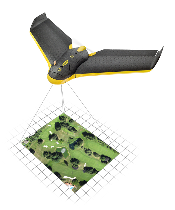
The eBee Sensefly UAV. Photo: Advanced Aviation Solutions
The Federal Aviation Administration (FAA) today granted two more regulatory exemptions for unmanned aircraft systems (UAS) operations for commercial use.
The two companies are Advanced Aviation Solutions of Spokane, Wash., and Tierra Antiqua Reality of Tuscon, Ariz. Advanced Aviation Solutions plans to fly an eBee senseFly UAV Ag system carrying a georeferenced still camera to conduct photogrammetry and crop scouting in order to perform precision agriculture.
The eBee Ag system consists of a 1.5-pound battery-powered aircraft, a personal computer-based ground control station, and associated communications equipment. The UAV is a fixed-wing aircraft with a wingspan of about 3 feet and 2 feet in overall length, which can operate at a maximum speed of about 50 knots.
Tierra Antiqua Reality plans to operate a Phantom 2 Vision+ UAS, which is comprised of an unmanned aircraft and a transportable ground station. The company plans to attach a small ultra-6 lightweight GoPro 3+ camera to the Phantom and operate it over various areas near Tucson to enhance academic community awareness and augment real estate listing videos.
The Phantom is a 3-pound quadcopter with a maximum airspeed of 30 knots.
The Federal Aviation Administration (FAA) today granted five regulatory exemptions for unmanned aircraft systems (UAS) operations to four companies representing several industries that promise to benefit from UAS technology, including Trimble Navigation Ltd.
The four companies that received exemptions want to fly UAS to perform operations for aerial surveying, construction site monitoring and oil rig flare stack inspections.
“Unmanned aircraft offer a tremendous opportunity to spur innovation and economic activity by enabling many businesses to develop better products and services for their customers and the American public,” Transportation Secretary Anthony Foxx said. “We want to foster commercial uses of this exciting technology while taking a responsible approach to the safety of America’s airspace.”
The commercial entities that received exemptions today are Trimble Navigation, VDOS Global, Clayco, and Woolpert (two exemptions). The FAA earlier granted exemptions to seven film and video production companies. This is the first exemption granted to a leading GNSS firm.
Secretary Foxx found that the UAS in the proposed operations do not need an FAA-issued certificate of airworthiness because they do not pose a threat to national airspace users or national security. Those findings are permitted under Section 333 of the FAA Modernization and Reform Act of 2012.
The firms also asked the FAA to grant exemptions from regulations that address general flight rules, pilot certificate requirements, manuals, maintenance and equipment mandates. In their petitions, the firms said they will operate UAS weighing less than 55 pounds and keep the UAS within line of sight at all times.
The exemption will allow Trimble to conduct commercial operation of its UX5 Aerial Imaging Solution. The UX5 is an unmanned fixed-wing aircraft targeted at the surveying, agriculture, oil and gas, mining, construction, environmental industries. The system autonomously captures a series of high-resolution images during flight, which is typically up to 50 minutes covering as much as 2.3 square kilometers (approximately 1 square mile) when flying 120 meters (approximately 400 feet) above the ground. Using Trimble Business Center Aerial Photogrammetry software, images are used to easily generate 2D and 3D deliverables such as orthomosaic images, three-dimensional point clouds and contour maps. The Trimble UX5 enables the collection of large amounts of data, often faster than traditional surveying or mapping technologies.
The Trimble UX5 surveys a construction site. Photo: Trimble
“We are pleased to be among the first companies to receive an exemption from the FAA authorizing commercial operation of UAS,” said Erik Arvesen, vice president of Trimble’s Geospatial Division. “This decision reflects Trimble’s efforts to responsibly operate its UAS business in the U.S. while the FAA addresses air safety issues in opening the NAS for commercial UAS operations on a broader scale. Trimble will continue its efforts to support the FAA’s decision-making process and to provide opportunities for our customers to safely use the UX5 to capture accurate geospatial data for a wide range of applications such as surveying, oil and gas, mining, construction and many more.”
“In the agriculture market, the FAA exemption moves Trimble one step further with the opportunity to provide a solution for safe and legal UAS operations that can benefit growers, ranchers, water management contractors, agronomists and other ag service providers,” said Joe Denniston, vice president of Trimble’s Agriculture Division. “High-speed aerial imaging is a powerful tool that can quickly and easily capture aerial images for scouting and monitoring crop health, locating cattle and their available forage over large areas, measuring crop height, and generating topographic maps and models for land leveling and drainage applications. As a result, the system can be a powerful data collection tool that can aid with recommendations to improve farming operations.”
In granting the exemptions, the FAA considered the operating environments and required certain conditions and limitations to assure the safe operation of these UAS in the National Airspace System. The agency also will issue Certificates of Waiver or Authorization (COAs) that mandate flight rules and timely reports of any accident or incidents..
“The FAA’s first priority is the safety of our nation’s aviation system,” said FAA Administrator Michael Huerta. “Today’s exemptions are a step toward integrating UAS operations safely.”
As of today, the agency has received 167 requests for exemptions from commercial entities.
AgJunction, a provider of hardware and software solutions for precision agriculture, today announced the release of its latest aerial guidance product, the LiteStar III from Satloc at the National Agricultural Aviation Association annual convention in Louisville, Kentucky.
As the next generation of affordable GPS guidance system for aerial applicators, LiteStar III builds upon the features of the previous LiteStar II system with more attributes, including simplified navigation set-up and guidance options.
“LiteStar III continues to represent the high-value, low-cost solution for entry level aerial applicators,” said T. J. Craig, director of sales for Satloc. “And now, the redesigned system features an all new ultra-bright L7 light bar that improves safety and minimizes fatigue.”
The LiteStar series of aerial GPS systems have provided consistent market success for Satloc for more than a decade, accumulating a large installed base. “The new LiteStar III marks the beginning of a technology upgrade path for many of our customers,” added Craig.
“One of the best features is the quick return on investment that operators can expect from the LiteStar III system,” Craig said. “It’s not only a low-cost reliable option for aircraft guidance, but the light bar provides the core information the operator needs for an aerial application, including on-swath indicators and spray on/off indicators.”
The product is being showcased this week at Satloc booth #829 at the NAAA annual convention and is available through Satloc dealers.
Topcon Positioning Group has completed the acquisition of Wachendorff Elektronik GmbH and Wachendorff Electronics Inc. in a private transaction.
Wachendorff Elektronik GmbH and its U.S. subsidiary Wachendorff Electronics, Inc., are manufacturers of in-cabin mounted consoles for the industrial vehicle market in the agricultural and construction industries.
“This acquisition is a key ingredient of our global strategy to strengthen our ability to serve original equipment manufacturers (OEM) and establish the foundation for Topcon manufacturing in Europe,” said Ray O’Connor, Topcon Positioning Group president and CEO. “This world-class facility in Germany is second-to-none in its operational quality, employee dedication, and astute leadership — all of the characteristics needed to exceed the high-precision standards required for our industry.”
“This transaction is an example of our commitment to expand our portfolio of high-quality products and become the world’s leading provider of in-cab consoles for the agricultural and construction OEM markets,” said Albert Zahalka, president of Topcon Precision Agriculture and leader of the acquisition team.
The Wachendorff family founded Wachendorff Prozesstechnik GmbH & Co KG in Geisenheim, Germany in 1978. Wachendorff Elektronik was founded in 1985.
According to a new market research report published by MarketsandMarkets, the total Yield Monitoring Devices and Services Market is expected to reach $2.51 Billion by 2020, growing at a CAGR of 7.17% from 2014 to 2020.
The report, “Yield Monitoring Devices and Services Market by Technology (GPS/GNSS, GIS, Remote Sensing), Components (Sensors, GPS/GNSS, Display, Guidance & Steering, and Software & Services), Application (VRA, Field Mapping, Soil Monitoring, and Scouting), and Geography – Global Forecasts to 2020”, is available now. It includes 65 market data tables and 64 figures spread through 208 pages and an in-depth TOC.
Yield monitoring is considered by farmers to be essential as yield data is recorded automatically while harvesting crops. Yield monitoring and mapping offers many other on-farm and off-farm benefits such as real-time availability of information, creation of a spatial database, and evaluation of whole-field improvements. Yield monitoring devices and services are implemented for site-specific farming, which ensures better efficiency, high yield, and profitability with optimum usage of resources. Yield monitoring techniques have major applications in variable rate application (VRA), soil monitoring, field mapping, and crop scouting.
Despite the rapid growth of global commerce and the widespread availability of equipment for yield monitoring and VRA, adoption rates appear to differ sharply from one country to another. The increasing demand for food is propelling the growers to adopt yield monitoring techniques and optimize their resources efficiently with minimum wastages.
The report provides a detailed segmentation by technology, component, and application. The geographic analysis covers all existing and emerging technologies in the yield monitoring devices and services market. The market based on technology is segmented into guidance system and remote sensing. The market based on hardware components and software is segmented into hardware components such as sensors, GPS/GNSS devices, display devices, guidance, and steering; and software services such as yield data management software as well as consulting and training services. The report also covers major applications of yield monitoring techniques such as field mapping, VRA, soil monitoring, and crop scouting with qualitative and quantitative industry insights.
One of the objectives of the report is to analyze market trends for each of the Yield Monitoring Devices and Services Market segments and their respective growth rates. Apart from market segmentation, the report also covers an in-depth analysis such as Porter’s five force analysis, supply chain with a detailed process flow diagram, and market dynamics such as drivers, restraints, and opportunities for this market.
Farmers Edge, a precision agriculture and independent data management solutions company, has received an investment from Kleiner Perkins Caufield & Byers’ Green Growth Fund. With operations around the world, Farmers Edge provides a plug-and-play technology solution that helps farmers optimize crop inputs and maximize yield. The investment from Kleiner Perkins will fund expansion of Farmers Edge’s technology platform and support the company’s continued growth in international markets, Farmers Edge said.
“We see a huge market opportunity for Farmer’s Edge approach to precision agriculture. They uniquely integrate real-time satellite imagery and in-field telematics to maximize yield and minimize environmental footprint,”said Kleiner Perkins Partner, Brook Porter. “Farmer’s Edge is leading the current disruption around how crops are grown, and ultimately how crops are valued as traceability becomes an increasingly important factor in the food supply chain.”
On the heels of a recent acquisition, Farmers Edge has introduced FarmCommand, a comprehensive solution that provides farmers plug-and-play real-time equipment diagnostics and logistics telematics to any brand of equipment. FarmCommand will become part of the Precision Solutions product line that incorporates field-centric data such as drone and satellite imagery, soil testing, weather stations and precision agronomy. By coupling cloud-based software, Precision Solutions and FarmCommand, with an agnostic hardware solution, growers gain the ability to make comprehensive precision farm management decisions.
“We rely on Farmers Edge to function as an independent advisor, providing us with a no-hassle, turnkey solution to increase our profitability,” said Jerry Machacek, grower at Canora, SK. “They bring a level of hands-on service that is unique in the industry which is the reason we trust them with the management of our acres.”
“From seed selection to yield data analytics, we bring all the information together to make a meaningful impact on production and we stick by our customers to ensure the job gets done right,” said Wade Barnes, president and CEO of Farmers Edge. “We have an established history of partnering with both farmers and leading distributors to deliver products which will benefit the farmer and his trusted advisors.”
GPS World staff will be reporting from InterGeo October 7-9. The massive trade show, held this year in Berlin, is considered the world’s leading conference trade fair for geodesy, geoinformation and land management. With more than 16,000 visitors from 80 countries, it is one of the key platforms for industry dialogue.
Staff members attending include GPS World Editor and Publisher Alan Cameron, Survey/GIS Editor Eric Gakstatter, and Digital Editor Joelle Harms. All three are accepting meeting invitations for companies interested in discussing their products and services. Contact [email protected].
VIDEO PLAYLIST
PHOTOS
Photo: GPS World
Topcon demonstrates its LN-100W, an update to its line of 3D positioning systems designed for one-operator layout. Photo: GPS World
German-based Multirotor by servicedrone is a UAV for professional 3D orthography. Photo: GPS World
Attendees listen to a presentation on the show floor at InterGeo held October 7-9 in Berlin. Photo: GPS World
Attendees watch UAV demonstrations at the conference’s flight zone. Photo: GPS World
Attendees take a look at one of the many UAVs seen at InterGeo 2014 in Berlin. Photo: GPS World
German-based Moskito GIS GmbH displayed a model from its 5 Power GIS. Photo: GPS World
BRS Motorsport Formula Students from Bonn-Rhein-Sieg University of Applied Sciences showcase their simulator, sponsored by CPA ReDev. Photo: GPS World
Riegl debuted and demonstrated its RiCOPTER UAV with LiDAR Integration. Photo: GPS World
At dusk the night before the conference the moon overlooks the Brandenburg Gate, an 18th century arch in Berlin and one of its most well-known landmarks. Photo: GPS World
Summary: UAVs (unmanned aerial vehicles) are taking over the surveying industry, thanks to their ever-improving sensors and the fact that they are getting lighter and can therefore remain in the air for longer. They complete surveying and inspection tasks that would otherwise be difficult to tackle, and do so with impressive cost-efficiency. UAV trends and technology will be among the focal points at the InterGeo conference in Berlin in early October.
Our correspondents will return with a fresh report, moderated by GPS World Editor and Publisher Alan Cameron and Survey Scene Editor Eric Gakstatter.
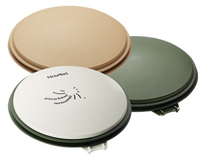
The NovAtel GPS-702-GG-HV high-performance pinwheel antenna comes in three colors. Photo: NovAtel, Inc.
NovAtel, Inc., has introduced the GPS-702-GG-HV to its line of high-performance Pinwheel antennas. Tracking L1/L2 GPS and L1/L2 GLONASS frequencies, customers can use the same antenna for GPS-only or dual constellation applications, reducing equipment costs and need for future redesign, the company said.
With the same form-factor and choke ring performance as the company’s other pinwheel antennas, the GPS-702-GG-HV has been enhanced even further to provide the robustness needed for use under high-vibration conditions.
The phase center of the antenna remains constant as the azimuth and elevation angle of the satellites change. Signal reception is unaffected by the rotation of the antenna or satellite elevation, so placement and installation of the antenna can be completed with ease. With the phase center in the same location for both the L1 and L2 signals and with minimal phase center variation between antennas, this antenna is designed for baselines of any length.
Enclosed in a durable, waterproof housing, the GPS-702-GG-HV comes in three colors: NovAtel standard grey, as well as desert tan and olive drab for military customers. The antenna is available for order beginning September 12.
Topcon Positioning Group has released two unmanned aerial systems (UAS) for mapping — the Sirius Pro and Sirius Basic. Both systems are designed to produce the most accurate solutions for the automated mapping of a wide range of sites — regardless of terrain — including construction sites, mines and quarries, and for use in land surveying, power line and pipeline inspection as well as precision agriculture field mapping.
The fixed-wing systems resulted from a partnership with MAVinci GmbH, a UAS development company with which Topcon recently entered into a worldwide distribution agreement.
“The Sirius Pro system is unique to the UAS marketplace. Instead of using traditional ground control points, Topcon combines RTK (real-time kinematic) GNSS solutions with precision timing technology to provide more accurate mapping results when compared to other products,” said Eduardo Falcon, executive vice president and general manager for the Topcon GeoPositioning Solutions Group.
“The system is easy to use and rugged — allowing operators to use a simple hand launch with precise automatic operation from takeoff to landing, and it can be flown safely in nearly all weather conditions,” Falcon said.
The Topcon Sirius Basic is an entry-level system offering many of the advantages of the Sirius Pro with options to upgrade. “The Sirius Basic shares the same hardware components of the Pro model, providing affordability with the same level of sturdiness and ease of operation,” said Falcon. “Additionally, when the need arises for the increased accuracy and productivity of the Pro system, a simple upgrade makes the transition practically effortless.”
Both systems also offer autopilot assisted manual control, automatic flight planning and safety features.
Research and Markets has announced the addition of the “GNSS Market Outlook 2020” report to its offerings.
Research and Markets explained that GNSS has developed its applications across various industries worldwide. Some applications are simple, such as determining a position, whereas others are complex blends of GNSS with communications and other technologies. Over the past few years, the rapid growth in GNSS commercial applications has been observed by the firms building navigation satellites and equipment. According to the report, the GNSS market is expected to flourish with new technological applications and is anticipated to grow at a CAGR of 9.4 percent during 2014-2020.
The report “GNSS Market Outlook 2020” is an outcome of the research company’s exhaustive research and comprehensive analysis of the worldwide GNSS market. “Our report provides a complete overview of the GNSS market globally. Over and above, all the current trends and drivers coupled with the potential growth areas of the GNSS industry have been evaluated in the report,” the company said in a statement.
The report analyzes the GNSS market by its major application areas such as location-based services, transportation, surveying, and agriculture, over a period of eight years (2013-2020). In addition, the transportation section covers the GNSS market by road, rail, air, and marine navigation segments, which are creating a wide opportunity to the overall GNSS market, according to the report.
The report provides extensive analysis of the GNSS market by each of these segments up to 2020.
Topics Covered:
1. Analyst View
2. Research Methodology
3. Global Navigation Satellite Systems (GNSS) – Overview
Trimble has added advanced line acquisition technology to its Autopilot automated steering system Trimble OnSwath technology. The acquisition technology reduces the time lost turning at the end of a row by enabling the vehicle to make a tighter turn and approach the next line, or crop row, 50 percent faster.
Using OnSwath, the farmer can decrease idle driving time, fuel consumption, soil compaction, crop damage, and working time in the field — which can lead to cost savings. OnSwath is a free upgrade to customers using the Trimble Autopilot automated steering system.
The new OnSwath technology allows the user to customize their line acquisition to the vehicle, operation, and operator preference including adjusting turn angle, approach angle, and speed. Using OnSwath, the vehicle projects its path to the line, which allows it to get online faster. As a result of these improvements, vehicle performance is more controlled, predictable, and repeatable.
“By adding OnSwath to Trimble’s Autopilot steering system, we’ve enabled farmers to be more efficient with their field operations,” said Erik Ehn, Smart Machines business area director of Trimble’s Agriculture Division. “OnSwath saves time, money and fuel, while also decreasing soil compaction and crop damage. Since we’re providing the technology at no additional cost, farmers who use Trimble’s automated guidance can leverage OnSwath and measure how much it can save their farm.”
“With Trimble’s OnSwath, I’m able to get online much faster and more accurately,” said Joe Brightly, who began using the OnSwath technology this spring for planting and strip tilling operations. “After an end of row turn, I can get online in a matter of only a few feet, which has saved me a lot of time.”
OnSwath is available with a software update to the Trimble Autopilot system.
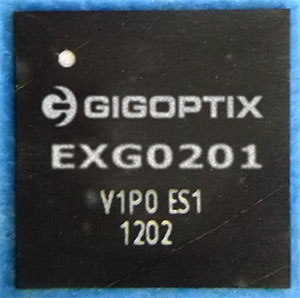
GigOptix, Inc., is making available samples of its newest GNSS RF receiver for road, maritime, agriculture and surveying applications.
GigOptrix is a supplier of advanced high speed semiconductor components for use in long-haul, metro, cloud connectivity, data centers, consumer electronics links and interactive applications, through optical and wireless communications networks.
The new EXG0201 device is expected to be one of several RF-focused products the company will bring to market over the next few quarters stemming from the recently acquired Tahoe RF Semiconductor, now called the GigOptix-Auburn RF Design Center after its integration into GigOptix earlier this month.
The new EXG0201 product marks the introduction of GNSS RF receivers by GigOptix. It is a low-power consumption, highly linear RF GNSS receiver in a small Quad Flat No-Lead (QFN) package. The fully integrated device is optimized for industrial applications and has dual channels supporting both the upper and lower GNSS bands.
The EXG0201 provides two modes of operation, a high-resolution mode and a low-resolution, low-power mode. It integrates RF signal processing, 12 or 3-bit analog to digital convertors, dual fractional-N synthesizers (with a shared reference to generate RF LO signals) and a three-wire SPI digital interface to provide the necessary functionality required to create a high-end GNSS receiver system. All of the EXG0201 sub-systems are programmable through the use of the on-chip SPI interface.
The GNSS industrial market, supporting road, maritime, agriculture, and surveying applications, is expected to grow to 67% in annual shipments to 43 million devices. The road segment dominates the annual quantity consuming about 98% of the total shipments. The road segment’s growth is driven by increased regulatory pressure for E911 emergency location calls.
“The EXG0201 represents our introduction of fully integrated RF-to-bits devices into a growing GNSS market, and serves as a proof point to the strategic importance of the Tahoe RF acquisition. The newly acquired IP and product capabilities put us in an excellent position to provide differentiated solutions and increased business over the long-term,” said Irshad Rasheed, director of marketing for wireless and RF products at GigOptix. “From a capabilities standpoint, the EXG0201 provides excellent performance with 28 MHz of signal bandwidth, dual-channel operation, 60 dB of instantaneous dynamic range, and 75 dB of gain, all contained within a small 72-pin QFN package.”
The EXG0201 is expected to ship in full production quantities starting in the fourth quarter of fiscal 2014.