Tag: precision agriculture

  • EUSPA tests prove suitability of Galileo HAS for precision agriculture

    EUSPA tests prove suitability of Galileo HAS for precision agriculture

    The Galileo High Accuracy Service (HAS) was tested under real farming conditions to assess its performance and suitability for precision agriculture

    The European GNSS Service Centre (GSC) of the European Union Agency for the Space Programme (EUSPA) partnered with Hemisphere GNSS and Case New Holland to test the suitability of the Galileo HAS service for precision agriculture.

    The tests were performed at the New Holland campus in Peñarrubias del Pirón, Segovia, Spain.

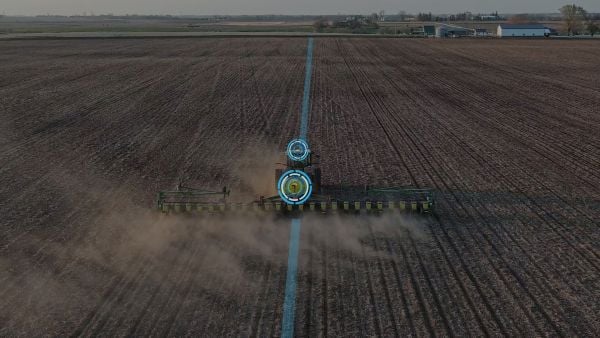
    The working width used for the test was 2.55 m, while the test area covered approximately 20,000 m² with a perimeter of about 740 meters. During the three-hour test, the teams collected GNSS data to analyze the pass-to-pass and absolute accuracy metrics. Pass-to-pass accuracy is the relative precision of a guidance system to maintain a consistent distance between adjacent, parallel machine passes within a short timeframe (usually 15 minutes). It is crucial for reducing gaps and overlaps during planting, spraying, and harvesting.

    Test campaign

    The test campaign aimed at proving that the tractor consistently maintained the specified path accuracy during consecutive passes. This would show that HAS can optimize agricultural operations by reducing costs associated with overlaps (reworking the same area), leading to savings such as reduced fuel consumption, minimal input waste, and improved crop yield.

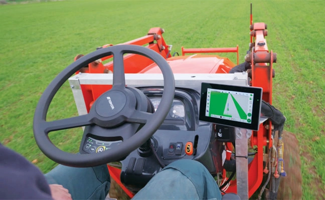
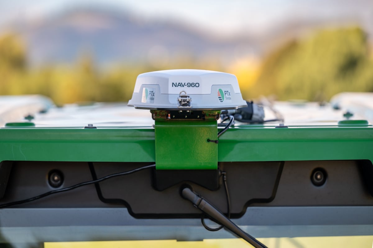
    For the test setup, in addition to the onboard guidance system, an independent antenna was mounted on the tractor cab. This antenna was connected to two positioning solutions: one based on the Galileo HAS and another based on an RTK solution.

    An RTK base station deployed for the occasion provided the rover with precise RTK corrections and enabled generating a “reference path” against which to compare the tested Galileo HAS, in this case based on corrections obtained directly from the signal in space (SIS) via the Galileo E6 band.

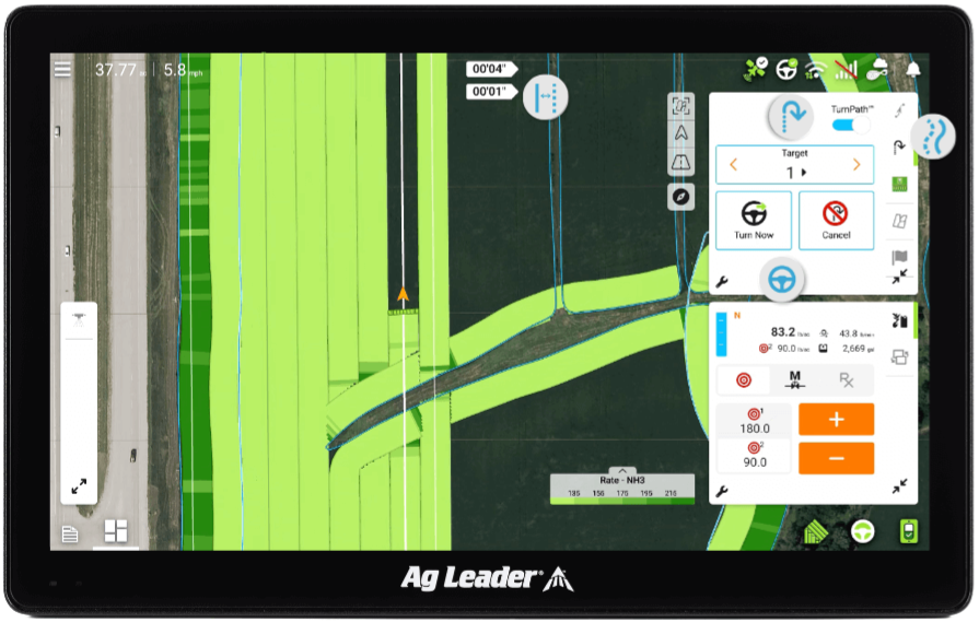
    The driving was performed in automatic mode, with manual intervention required only for turning at the end of each pass. The autosteering system of the tractor would then automatically reconnect with the following path, as calculated at start-up.

    Test results

    The test began with the GNSS receiver in Cold Start mode, requiring it to obtain ephemerides and process satellite data before achieving precise positioning. The convergence time was calculated and is shown as the red area in the image below. The green area shows when the tractor started along the predefined paths and hence when the data was used for the pass-to-pass accuracy calculation.

    Converge time and data set during the test. (Credit: EUSPA)
    Converge time and data set during the test. (Credit: EUSPA)

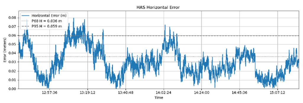
    The data analysis showed that the Galileo HAS system consistently maintained horizontal errors of 3-6 cm.

    With a 95% horizontal error of 5.9 cm and its maximum value below 8 cm, the error remains well below the 20 cm HAS accuracy target.

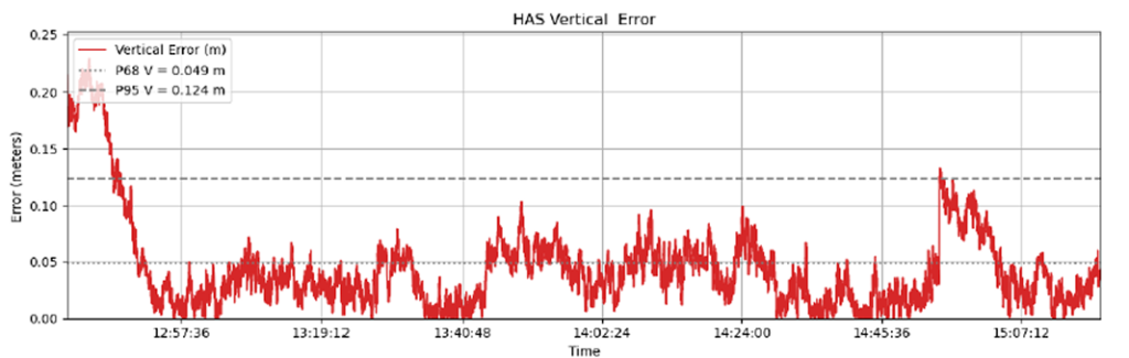
    As regards the vertical axis, the 95% vertical error was 12.4 cm, with its maximum value below 25 cm, (remaining well below the 40 cm HAS accuracy target).

    Galileo HAS signal vertical error. (Credit: EUSPA)
    Galileo HAS signal vertical error. (Credit: EUSPA)


    The horizontal error of the HAS service relative to the RTK reference baseline is shown in the following figure.

    Galileo HAS signal horizontal error. (Credit: EUSPA)
    Galileo HAS signal horizontal error. (Credit: EUSPA)

    Regarding the pass-to-pass accuracy, the analysis shows an overall pass-to-pass accuracy of 1.18 cm, demonstrating highly stable performance throughout the test period.

    Year-to-Year accuracy was not part of this testing campaign but will be analysed in the next testing campaign.

    Galileo HAS potential confirmed

    The Galileo HAS service is an open, standardized correction service distributed directly via Galileo E6 or the internet (with global coverage) and the test campaign results confirm its potential to generate savings to farmers in terms of fuel consumption, fertilizers, seeds and other inputs, by reducing overlap in field operations.

  • Topcon launches innovations aimed at farmers at Brazil Agrishow

    Topcon launches innovations aimed at farmers at Brazil Agrishow

    As Brazilian farmers face increasing pressure to improve efficiency while managing rising input costs, Topcon Agriculture has announced a new set of innovations designed to expand access to precision technology across Latin America.

    At Agrishow 2026, taking place April 27–May 1 in Brazil, Topcon will showcase solutions for row crop, coffee, citrus and sugarcane growers, including an expansion of its Value Line portfolio into vineyard and orchard spraying applications, as well as the introduction of a new modular GNSS receiver for precision agriculture.

    XR-1P GNSS receiver

    Modular GNSS receiver. Topcon is introducing the XR-1P GNSS receiver, designed to deliver reliable positioning and manual guidance in a cost-effective, durable unit. Engineered with modular architecture, the XR-1P can be used as a standalone solution or integrated into broader Topcon systems, offering flexibility for a wide range of farming operations.

    The receiver is designed to bridge the gap between entry-level positioning solutions and high-performance precision agriculture systems, making advanced GNSS technology more accessible without compromising reliability.

    CM-20 V spray controller

    Expanding precision spraying for specialty crops. The CM-20 V Spray Controller, part of Topcon’s vineyard and orchard spraying control portfolio, is now available for use with the Value Line Steering solution. Designed for front-wheel-drive, mid-range tractors, the system offers an economical and scalable approach to precision spraying for specialty crops such as coffee and citrus.

    The universal ISOBUS electronic control unit (ECU) integrates easily with existing farm equipment, regardless of brand, while on-the-go sensor-based control adjusts application rates based on crop density. This helps reduce input waste, minimize over- and under-application, and improve overall crop health and operational efficiency.

    Sugarcane solution preview. An advanced look at a pre-commercial Sugarcane Yield Monitoring Solution will be showcased at the event. In development with the specific needs of Brazilian agriculture in mind, the solution will provide accurate, real-time yield visibility designed to maximize harvester efficiency, optimize logistics and support precision agronomy. By enabling more precise decision-making, the solution will help reduce input usage while increasing productivity in one of the country’s most strategic crops.

    Boom height controller

    Brazil is a strategic market for Topcon Agriculture, as it is one of the world’s leading food producers. Topcon supports the region not only through innovations tailored to local agricultural needs but also through a strong and expanding network of distributors that provide access to technology, training, and ongoing support. Authorized dealers, including Agrosure, Alagro, Coopercitrus and WiseAgri in Brazil, as well as Nievas in Argentina and Gestecner in Paraguay, will be at the Topcon stand during Agrishow.

  • Wherobots, Felt partner to modernize geospatial data tools

    Wherobots, Felt partner to modernize geospatial data tools

    Wherobots and Felt have entered a strategic partnership aimed at modernizing the geospatial data stack.

    The integration combines Wherobots’ spatial intelligence lakehouse and compute engine with Felt’s collaborative mapping platform, connecting large-scale data engineering with interactive, map-based applications. The partnership allows organizations to move from processing petabyte-scale geospatial datasets in the cloud to exploring insights in a collaborative mapping environment without transferring large datasets between systems.

    Organizations are handling growing volumes of location-based data, and analyzing that data has historically required specialized GIS software or custom applications that were difficult to connect with modern data systems. The integration lets users create live, interactive visualizations for uses ranging from mapping fields and creating vegetation indexes to building AI-enabled user experiences and automated workflows that monitor climate risks.

    Agricultural company puts partnership to the test

    Leaf Agriculture, which provides a unified API for agriculture organizations and farms working with telemetry data from tractors and field sensors, is already using both platforms together.

    The company uses Wherobots to create data products from a large data lake of agricultural, parcel and tractor telemetry datasets. It recently announced a new product, LeafLake, built on that foundation. Leaf then uses Felt to build interactive maps based on the spatial data processed within Wherobots. Rather than relying on in-person screen-sharing sessions, the team now distributes maps via links viewable from any device. Here is an example of one of Leaf’s interactive maps.

    “Wherobots and Felt’s new integration allows organizations to move seamlessly from processing petabytes of raw geospatial data in the cloud to visualizing actionable insights in a browser-based, collaborative environment — all without the friction of traditional desktop-based tools,” said Rachel Zack, chief strategy officer and co-founder at Felt. “For modern enterprises who rely on geographic information, this is the complete, end-to-end spatial data infrastructure that makes working with GIS data at scale finally feel effortless.”

    “As climate impacts intensify — from fires to floods — maps are no longer optional; they’re critical tools for understanding a rapidly changing world,” said Mo Sarwat, CEO of Wherobots. “Yet building and scaling them has traditionally required heavy engineering effort, especially for teams working with satellite and drone data. Through our partnership with Felt, AWS users can now access, analyze and visualize spatial data directly from S3, eliminating infrastructure complexity and accelerating decision-making when it counts most.”

    For more details, please see the Wherobots blog post here.

  • RightPath designed to keep implements on track

    RightPath designed to keep implements on track

    Ag Leader has launched RightPath, a passive implement steering solution, to alleviate issues in precision agriculture resulting from drift.

    Putting the right seed in the right location with the right fertilizer is critical for farmers, and has led to the wide adoption of technology such as autosteer. However, if the pass-to-pass accuracy isn’t perfect at planting, the crop is vulnerable to damage in subsequent passes, which drags down yield.

    Trailed implements are known for drifting off the guidance line even when farmers use autosteer. The result is inaccurate placement of inputs and inconsistent guess rows. This is an issue because accuracy drives yield.

    Photo:
    RightPath is designed to operate seamlessly through Ag Leader’s InCommand Go displays. (Image: Ag Leader)

    A passive implement steering solution, RightPath keeps implements centered on the guidance line. This not only ensures precise input placement but also increases operational efficiency throughout the growing season, while minimizing crop damage, yield loss, and operator challenges.

    RightPath enables farmers to:

    • place the implement — and therefore rows and inputs — in the right place. 
    • plant seed accurately relative to a previous operation such as strip-till or NH3.
    • achieve consistent guess rows in all conditions including curves and uneven terrain.
    • re-use the same guidance line in the next field activity.
    • reduce stress and fatigue.

    RightPath is designed to operate seamlessly through Ag Leader’s InCommand Go displays. In addition, RightPath is compatible with both SteerCommand Z2 and SteadySteer, Ag Leader’s integrated and assisted steering solutions.

    While both the vehicle and implement require Ag Leader’s GPS 7500 to utilize RightPath, only the vehicle needs to be equipped with TerraStar-C, TerraStar-L or RTK. This gives an operator the flexibility to choose the right GPS correction for different operational needs.

    RightPath is available now through a single purchase unlock, with no recurring subscription fee.

  • Calian GNSS launches advanced antennas for high-precision operations

    Calian GNSS launches advanced antennas for high-precision operations

    Calian GNSS, a leader in high-precision antenna technology, has introduced the Accutenna 4 (AC4) antenna family for increased accuracy, reliability and performance across the full GNSS spectrum.

    Based on a novel stacked composite patch antenna element, the AC4 element combines a robust and compact, full band quad-feed design, in half the weight of current patch antennas on the market. Its highly efficient radiating element and precise phase pattern associated with Calian’s proven eXtended Filtering (XF) technology will deliver clean and accurate signals, even in today’s crowded RF environment.

    Whether it’s surveying, autonomous systems, precision agriculture or defense, the AC4 ensures users can rely on GNSS data when it matters most.

    Designed with precision applications in mind:

    • Full GNSS band coverage. Supports GPS, Galileo, BeiDou, GLONASS, SBAS and correction services in one antenna, making it a versatile, future-proof solution.
    • Accutenna 4 technology. Four-feed compact stacked composite patch antenna minimizes multipath interference and keeps the phase centre stable, ensuring centimetre-level accuracy.
    • Lightweight, rugged options. Available as embedded (85 g) and in multiple mounting styles for diverse applications, from embedded systems to demanding field use.
    • Noise rejection. Integrated Extended Filtering (XF) technology blocks interference from new LTE and other signals that can disrupt GNSS performance.

    With the Accutenna 4, Calian GNSS expands its portfolio, reinforcing its role as a partner for organizations that depend on precision GNSS antenna innovation.

  • Value line steering solution upgrades mid-range tractors with autosteering

    Value line steering solution upgrades mid-range tractors with autosteering

    1. AUTONOMOUS STEERING PACKAGE

    Allows upgrades of older machinery for small farms 

    Topcon’s has created a Value Line Steering solution for farmers using mid-range tractors on small- to medium-sized farms. It makes autosteering technology — typically used on larger machinery — accessible to a broader range of farmers. Farmers with older or smaller machinery, or small specialty farms, can boost the value of their machinery with the autosteering technology. The integrated system is designed to work across a wide range of applications, machinery and brands. It includes compliance with ISOBUS-UT  to offer universal compatibility and ease of use. The package includes a GNSS receiver, electric steering wheel controller, touchscreen console and Horizon Lite software, compatible with front-wheel-steer tractors. Farmers can add local, satellite or RTK correction services such as Topcon’s Topnet Live for enhanced precision.  Topcon, topconpositioning.com 

  • U-blox and Nordian expand PointPerfect Flex further in South America

    U-blox and Nordian expand PointPerfect Flex further in South America

    U-blox has expanded its partnership with Nordian to deliver its PointPerfect Flex (PPP-RTK) centimeter-level correction services across Argentina and Paraguay, building on existing coverage in Brazil as part of a broader regional expansion strategy.

    The PointPerfect Flex GNSS correction service addresses growing demand from South America’s agriculture sector, while also serving drone operators, surveying and mapping professionals. The expanded coverage delivers centimeter-level accuracy at scale without requiring deployment of additional local base station infrastructure, enabling agricultural solution providers to implement precision automation solutions across remote areas where traditional RTK networks are not economically viable.

    PointPerfect and u-blox GNSS receivers are developed in close conjunction with each other to achieve optimum results. The system supports both SPARTN data format optimized for u-blox receivers and RTCM format for non-u-blox GNSS RTK receivers, ensuring broad compatibility.

  • JAVAD GNSS, Inertial Labs partner to deliver advanced GNSS+INS navigation platform

    JAVAD GNSS, Inertial Labs partner to deliver advanced GNSS+INS navigation platform

    JAVAD GNSS, a global provider of high-precision GNSS solutions, and Inertial Labs, a VIAVI Solutions Company, have entered a strategic partnership to integrate Inertial Labs’ IMU-P modules with JAVAD’s advanced OEM GNSS receivers. This collaboration introduces a new GNSS+INS platform designed to deliver accuracy, stability and resilience, even in environments where GNSS signals are weak or unavailable.

    Central to this advancement is the JAVAD TR-3Si receiver, engineered for compatibility with professional IMU modules. Combined with the advanced IMU-P units, the system is positioned to offer high levels of precision and reliability, supporting mission-critical requirements in aerospace, defense, autonomous vehicles, UAVs, robotics, precision agriculture and other demanding sectors.

    Inertial Labs’ IMU-P modules can perform in dynamic settings, providing continuous orientation and acceleration data for sensor fusion. The integration of this inertial technology with JAVAD’s established GNSS systems enhances navigation accuracy and efficiency in both GNSS-accessible and GNSS-denied environments.

    JAVAD GNSS is expanding its support for IMU modules and is expected to release further updates on this initiative.

  • Hi-Target and GMV sign strategic alliance on high-precision positioning solutions

    Hi-Target and GMV sign strategic alliance on high-precision positioning solutions

    Hi-Target, a Chinese high-precision positioning enterprise and manufacturer of high-end GNSS equipment, and GMV, a global technology group specializing in advanced navigation solutions, have established a strategic alliance to jointly develop integrated differential service solutions.

    Through this partnership, Hi-Target and GMV support a wide range of automation-driven positioning applications — ADAS, robotics, UAVs, precision agriculture, smart infrastructure and intelligent mobility systems.

    As industries progressively adopt automated technologies, precise and reliable positioning has become a foundational requirement across application domains. From today’s L2 and L2+ driver assistance systems (ADAS) in vehicles to autonomous UAV operations, robotic platforms, and the emerging needs of Level 3+ mobility solutions, the demand for scalable and high-accuracy positioning continues to grow.

    The strategic alliance between the two companies leverages Hi-Target’s strengths in high-precision satellite navigation and user-grade GNSS systems, along with GMV’s extensive global expertise in precise navigation algorithms and satellite-based augmentation services. The result will be a high-availability, low-latency positioning service with global reach.

    By combining their complementary technologies, including user-grade GNSS hardware, correction services, and augmentation infrastructure, Hi-Target and GMV will facilitate the adoption of high-precision positioning across various industries and geographic regions.

    Their collaboration will support system integrators, OEMs, and solution providers in accelerating the development and deployment of automation in sectors with increasing levels of autonomy.

  • PTx Trimble introduces next-generation guidance controller

    PTx Trimble introduces next-generation guidance controller

    PTx Trimble, formed as a joint venture in 2024 by AGCO and Trimble, is providing a new GNSS receiver for precision autoguidance: the NAV-960 guidance controller. The agriculture controller improves positioning accuracy and availability to deliver greater uptime while providing the computing power to support complex field operations and handle future developments.

    The PTx Trimble NAV-960 offers farmers an upgrade to its predecessor, the NAV-900, with a host of improvements, including enhanced speed, higher processing power and improved positioning performance. Using this receiver, farmers can handle the most complex and demanding applications for guidance and steering, creating improved uptime and the flexibility to seamlessly run field operations. This enables greater efficiency and boosts productivity.

    Benefits to farmers include saving on inputs from reduced overlap and less downtime that decreases operational delays and improves machine utilization, aimed at reducing operator fatigue during long planting days and improving overall productivity. Using the NAV-960 as part of a complete autosteering solution allows operators to focus on the fieldwork as it happens and allows growers to get work done faster, reducing wear and tear on equipment.

    With its cast aluminum base and sleek design, the NAV-960 is built to withstand tough farming environments, including searing heat, freezing cold, driving rain, persistent dust and everything in between. The additional processing power of the upgraded CPU ensures compatibility and readiness for fieldwork.

    New features include:

    • Patented industrial design with rugged, dust-, water- and vibration-resistant base
    • Enhanced GNSS engine to track more satellites than ever before, paired with enhanced inertial sensors, provides up to 50% improved vehicle positioning and line following performance compared to the NAV-900
    • Onboard Trimble ProPoint® technology with Trimble IonoGuard™ for maximum resistance to downtime caused by solar events and scintillation
    • Centimeter-level accuracy when used in combination with Trimble CenterPoint® RTX or RTK correction signals
    • Advanced quad core processor for extra power, faster calculations and improved data delivery speeds
    • Complete compatibility with current PTx Trimble steering systems, utilizing the same cables as the NAV-900 guidance controller

    Onboard Wi-Fi and Bluetooth will make the NAV-960 easier to support for service teams and ready to embrace future enhancements across the PTx Trimble solution portfolio. As part of the company’s commitment to its retrofit-first, mixed-fleet strategy, the NAV-960 is fully compatible with all GFX series displays including the GFX-350, -1060 and -1260 models.

    How Farmers Benefit

    Farmers who implement the new receiver will see improvements from the start, including:

    • Increased uptime and profitability
    • Reduced overlap and lower input costs
    • Reduced labor costs by maximizing operator effectiveness and eliminating idle time
    • Reduced stress and fatigue during long days in the cab, decreasing operator mistakes and errors in judgement

    The NAV-960 is available worldwide, providing a solid foundation for fieldwork today and is ready to handle technology developments in the future for both aftermarket and OEM installations.

  • u-blox launches PointPerfect Global, completing GNSS correction portfolio with worldwide coverage

    u-blox launches PointPerfect Global, completing GNSS correction portfolio with worldwide coverage

    u-blox has introduced PointPerfect Global, its new high-precision GNSS correction service designed for applications that require sub-decimeter positioning accuracy, such as precision agriculture, UAV-based mapping and autonomous outdoor robotics. The service offers global coverage, including remote areas, through both internet and L-band satellite broadcast.

    PointPerfect Global is engineered to provide convergence times under two minutes and accuracy of less than 10 cm. It uses Precise Point Positioning with Ambiguity Resolution (PPP-AR) corrections and is optimized for products built on the X20 platform. The u-blox ZED-X20P GNSS receiver will be the first device to support the new service, offering integrated L-band support for use in areas without cellular connectivity.

    PointPerfect Global expands the u-blox PointPerfect portfolio, which also includes PointPerfect Live, a regional nRTK service for the most demanding applications, and PointPerfect Flex, the original PPP-RTK service designed for flexible IoT deployments. Together, these services provide scalable, high-performance positioning solutions tailored to a range of technical and commercial requirements.

    The broadcast-based architecture of PointPerfect Global allows for scalable deployment across continents without the need for complex regional integration. This approach is intended to simplify logistics and operational complexity for OEMs and solution providers, supporting a variety of sectors including agriculture, robotics, UAVs, industrial automation, and automotive. The service is designed to deliver reliable performance with minimal infrastructure dependency, which is critical for mass-market autonomy and global scalability.

    Early access to PointPerfect Global is scheduled for late 2025, with general availability expected in the first half of 2026.

  • Rx Networks launches GNSS correction service with centimeter-level accuracy

    Rx Networks launches GNSS correction service with centimeter-level accuracy

    Rx Networks has introduced TruePoint | FOCUS, a high-precision, cloud-based GNSS correction service that offers instantaneous centimeter-level accuracy for a variety of applications. This service is designed to address the needs of industries requiring real-time precision, such as micro-mobility, smart agriculture, robotics, UAVs, IoT and machine control.

    TruePoint | FOCUS supports both Real-Time Kinematic (RTK) and PPP-RTK modes to offer flexibility and high performance. The RTK mode is hardware-agnostic, ensuring compatibility with any RTK-enabled GNSS receiver. It uses standard correction protocols like RTCM v3 and supports access via NTRIP for seamless integration and rapid deployment. The PPP-RTK mode leverages State Space Representation (SSR) to deliver high-accuracy positioning with optimized bandwidth usage. This mode combines the benefits of global coverage from PPP with the fast convergence times of RTK, making it suitable for applications requiring seamless operation over large areas.

    The service is notable for its ability to process more GNSS signals than many competing solutions, enhancing its resilience and performance in challenging environments. It supports signals from GPS, Galileo and BeiDou constellations, offering comprehensive correction capabilities. According to the company, TruePoint | FOCUS guarantees consistent centimeter-level accuracy with a 99.9% service level agreement, ensuring reliability for users operating in regions such as North America, Europe and China.

    TruePoint | FOCUS is available for trial in both RTK and PPP-RTK modes across covered regions, with plans to expand its geographic reach. Interested users can request a complimentary 30-day trial license to evaluate the service.