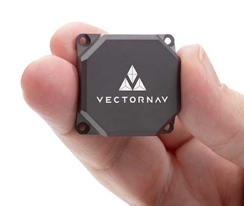
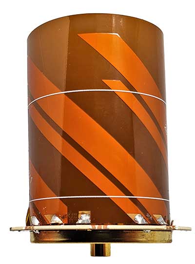
Tactical Embedded series of GNSS/IMUs. (Photo: VectorNav)
Embedded navigation company VectorNav Technologies has introduced a new line of inertial products: the VectorNav Tactical Embedded series of GNSS/IMUs.
Featuring a tactical-grade inertial measurement unit (IMU) and a multi-band GNSS receivers, the Tactical Embedded delivers milliradian attitude accuracy and centimeter-level positioning capability in a miniature 15-gram package.
VectorNav’s Tactical Embedded line is in a new smaller size, and enables cost reductions for a wide range of autonomous pointing and geo-referencing applications. These include gimballed intelligence, surveillance and reconnaissance (ISR), SATCOM systems, lidar mapping and photogrammetry, among many others.
The Tactical Embedded line supports external SAASM GPS for defense applications in ISR, electronic warfare, munitions and UAV navigation.
“The Tactical Embedded is the culmination of years of development to bring milliradian-level attitude performance and robust positioning into a form factor that represents a disruptive step in inertial navigation capability,” said VectorNav President John Brashear. “Systems integrators worldwide can now embed tactical-grade inertial navigation capabilities into their electronics, unlocking a range of new applications and possibilities.”
Designed and engineered at VectorNav’s AS9100-certified facility in Dallas, Texas, the Tactical Embedded line includes the VN-110E IMU/AHRS, the VN-210E GNSS-aided inertial navigation system (INS), and the VN-310E Dual Antenna GNSS/INS.
Highlights include:
0.05-0.1° heading; 0.015° pitch and roll
1 m horizontal and 1.5 m vertical position accuracy
A roundup of recent products in the GNSS and inertial positioning industry from the August 2020 issue of GPS World magazine.
OEM
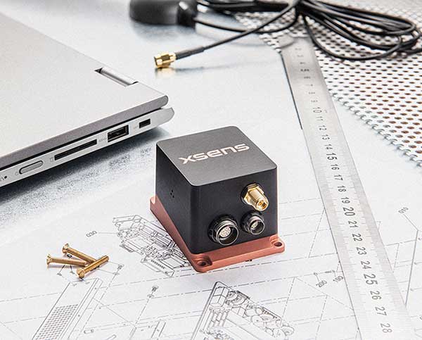
Photo: Xsens
RTK motion sensor
Provides Centimeter positioning
The MTi-680G is an integrated GNSS/inertial navigation system (INS) module that features an integrated real-time-kinematic (RTK) GNSS receiver, as well as providing synchronized 3D attitude and heading outputs. Its firmware accelerates the module’s internal signal processing compared to non-RTK modules. Synchronizing the global position coordinates with the module’s attitude, heading and velocity outputs, the MTi-680G can provide a comprehensive positioning and navigation output for any carrier device, including high-speed drones, at a maximum output data rate of 400 Hz. Other applications include precision agriculture, autonomous vehicles and coastal maritime equipment. Xsens provides out-of-the-box operation with MTi development kits.
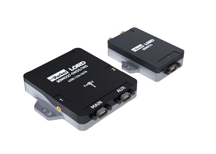
The 3DM-GQ7 is a dual-antenna real-time kinematic (RTK) inertial navigation system with multiple integrated aiding sensors and support for external aiding. It has two integrated RTK-capable multi-band multi-constellation GNSS receivers, integrated barometric pressure sensor, magnetometer, and hardware support for wheel odometry. It also has an application programming interface (API) for external sensor measurements. The 3DM-GQ7 provides seamless operation during temporary GNSS signal outages and online tracking of inertial measurement unit (IMU) error sources for superior dead reckoning. An optional network RTK receiver, the 3DM-RTK, allows users to communicate with the company’s SensorCloud RTK Connection network for an all-in-one solution.
Hexagon | NovAtel has released its first purpose-built driver, powered by Robot Operating System (ROS), to support its OEM7 family of GNSS receivers. The driver provides an optimized interface enabling users to accelerate autonomous development projects by quickly incorporating NovAtel OEM7 receivers into custom applications. The driver is available for immediate download through the new NovAtel GitHub repository or as a ROS Binary Package for direct installation.
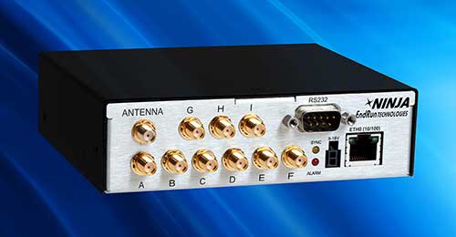
The third-generation Ninja Precision Timing Module (PTM) — optimized for size, weight and power (SWaP) — can be easily integrated into 1U host systems or deployed as a cost-effective standalone time and frequency standard. The resilient GPS-synchronized Ninja is based on the core of EndRun’s Meridian II Precision TimeBase instrument, providing time accuracy of <10 nanoseconds RMS to UTC(USNO). Up to nine optional, user configurable, time and frequency outputs are available with accuracy, stability and ultra-low phase noise. Ninja’s network interface includes a robust Network Time Protocol (NTP) server as well as secure management.
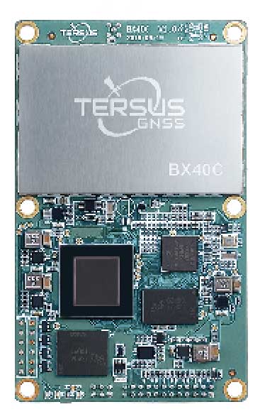
Powered by ExtremeRTK GNSS technology, the BX40C board can support multi-constellation and multi-frequency all-in-view satellite tracking to achieve centimeter-level positioning and improve the continuity and reliability of the RTK solution, even in harsh environments. Its enhanced positioning accuracy and constellation tracking can control deviation within 3 centimeters for surveying and mapping applications. It also is suitable for high-precision positioning. It can be integrated with autopilots and inertial navigation units. It offers 4 GB of built-in memory for data collection, and is compatible with other GNSS boards via flexible interfaces, smart hardware design and commonly used log/command formats.
The Spectratime mRO-50 is designed to meet the latest commercial, military and aerospace requirements where time stability and power consumption are critical. It provides a one-day holdover below 1 microsecond and a retrace below 1 x 10⁻¹⁰ in a form factor sized 50.8 x 50.8 x 19.5 millimeters. It takes up only 51 cc of volume and consumes only 0.45 W of power. The Spectratime mRO-50 provides accurate frequency and precise time synchronization to mobile applications, such as military radio-pack systems in GNSS-denied environments. It is also suitable for UAVs and underwater applications.
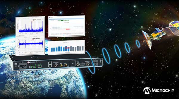
The BlueSky GNSS Firewall has received a major software update. The firewall provides a higher level of resiliency against GPS vulnerabilities for systems dependent on GPS signal reception. Microchip developed Release 2.0 to address operators’ evolving requirements after participating in GPS Testing for Critical Infrastructure events hosted by the Department of Homeland Security. It performs real-time analysis to detect jamming and spoofing for protecting reception of the GPS signal and hardening response and recovery to avoid signal disruption. Release 2.0 includes charting and advanced threshold settings of GNSS observables such as satellites-in-view, carrier-to-noise, position dispersion, phase time deviation and radio frequency power level to simplify system turn-up and deployment.
Particle’s Tracker SOM (system-on-module) provides a powerful GNSS receiver, microcontroller and advanced peripherals in a compact form factor. Tracker SOM can be tailored for organizations or serve as a fully certified foundation for OEMs developing commercial products. A high-gain GNSS antenna accurate to 1.8 meters is provided. The asset-tracking system is built on the Particle platform, spanning integrated internet-of-things (IoT) hardware, edge software, connectivity and cloud-based management software. It can track the real-time location of critical assets and capture additional intelligence such as temperature and acceleration as well as remotely control mobile equipment and vehicles.
The Geotab Public Works solution for North America helps state and municipal government agencies improve fleet operations and increase operational efficiencies. Fleet managers receive operational data on all government vehicle types on a single platform, with toolsets to remain compliant, reduce costs and maintain road safety. Vehicles tracked include salt spreaders, snowplows, street sweepers and waste-management vehicles. It supports material management, compliance, accountability and liability. Fleets can more accurately measure material usage, such as salt, and are better able to control costs and environmental impact. It is available as a configurable add-on for the MyGeotab platform, allowing municipalities of all sizes to customize their databases to help meet specific needs.
Scout provides the capability to securely obtain and broadcast a form of network remote ID. Because it is open source, both hardware and firmware can be enhanced and incorporated into a virtually limitless set of scenarios. Altitude Angel also has made available a surveillance API that allows integrators to both share and receive flight data from a variety of sensors and devices in near real time, providing a comprehensive real-time picture of the airspace. Scout offers two-way communication enabling the Altitude Angel UTM service to help the drone avoid collisions or restricted airspace. It will work in combination with a pre-flight (flight-plan sharing) service and is supported through integration with Altitude Angel’s Tactical Conflict Resolution Service. Scout will enable the drone to report its real-time location using GPS-type sensors and relay this data via a secure, encrypted mobile communications link to Altitude Angel.
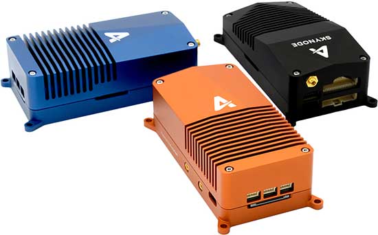
Unifies flight controller, mission computer and connectivity
Skynode unifies a flight controller, mission computer and wireless connectivity in a compact embedded design. It enables the complete Auterion software platform to accelerate the development of enterprise-ready products for drone manufacturers.Skynode can be integrated into any type of airframe: quads, multi-rotors, vertical-takeoff-and-landing (VTOL) and fixed-wing drones. Skynode enables the Auterion software platform with enterprise workflow integration, advanced autonomy features, mission planning, live video streams, operations dashboard, flight analytics and cloud-based predictive maintenance. Built on stable open-source software and industry standards, Auterion is highly interoperable with integrations from a host of partners in an open, future-proof ecosystem.
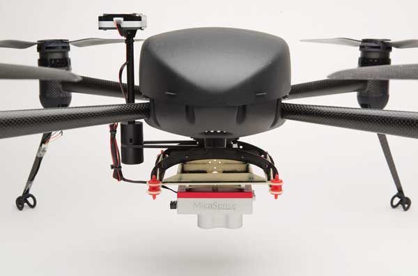
The Draganflyer Commander Ag-Pro Package includes everything needed to perform crop health assessment, irrigation monitoring and yield optimization. It combines the MicaSense RedEdge-MX multispectral sensor and the Draganflyer Commander UAV for projects requiring long flight times, a high level of data resolution and accuracy and data security. The Commander is an electric multirotor UAV built on Draganfly’s patented carbon fiber folding airframe. Its dual-battery system powers 35-minute flight times, and its automated flight planning tool allows users to quickly create coverage areas and flight plans. The RedEdge-MX features five narrowband imagers that capture high-quality images that can produce maps for a multitude of agricultural uses and has two calibration methods to produce accurate data that can be compared across time, allowing for temporal analysis throughout the season and from year to year.
Creates bare Earth models, cross sections, contours, volumetric analysis
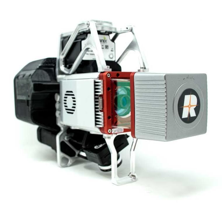
The True View 615 and 620 UAS lidar 3D imaging systems are compact, survey-grade sensors designed for small UAS. They are equipped with Riegl’s miniVUX-2UAV laser scanner integrated with dual photogrammetric cameras. Position and orientation is provided by an Applanix APX-15 (True View 615) or extreme accuracy APX-20 (True View 620). The systems are bundled with Applanix POSPac, True View EVO post-processing software and True View Reckon data-management solution. The system includes full post-processing software that generates a ray-traced 3D colorized point cloud and geocoded images.
Generates both survey-grade point clouds and high-resolution panoramas
The NavVis VLX wearable mapping system captures high-quality data in built environments such as construction sites, staircases and technical rooms. The compact, economical design enables high-quality data to be captured for architecture, engineering and construction (AEC) projects. Uses include conventional building documentation such as CAD drawings and BIM models, as well as web-based digital-twin solutions. NavVis VLX is equipped with two lidar sensors and captures survey-grade point clouds using the company’s SLAM technology, originally developed for the NavVis M6 indoor mobile mapping system. NavVis VLX also captures high-resolution panoramic images in a 360-degree field of view. The wearable device gives the operator more control over where the sensors are scanning. A built-in screen provides live feedback of what has been scanned and the quality of the data being captured.
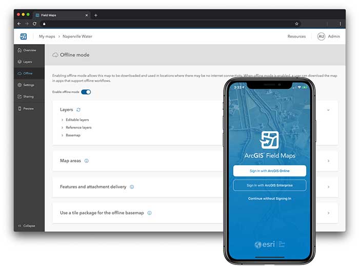
ArcGIS Field Maps, coming in September, will combine the following capabilities into a single app: map viewing and markup, high-accuracy field data collection and inspection, battery-optimized location tracking, work planning and task management and turn-by-turn navigation. Field Maps also will include a new web app, integrated with ArcGIS, that can be used to configure and deploy maps optimized for your mobile workforce needs, create and assign tasks to mobile workers, and create and share views of worker locations. ArcGIS Field Maps combines the functionality of five Esri ArcGIS mobile apps: Collector, Explorer, Tracker, Workforce and Navigator. Field Maps will also support the two formerly Collector-exclusive Eos solutions: Eos Locate and Eos Laser Mapping.
Empowered by a high-precision inertial measurement unit (IMU) on the Ultimate version, the Oscar from Tersus GNSS is a new generation of tilt survey receiver. Its calibration-free tilt compensation is immune to magnetic disturbances — holding the survey pole upright is no longer necessary. Powered by Tersus ExtremeRTK GNSS technology, Oscar can provide high accuracy and stable signal detection.
The built-in high-performance antenna can speed the time to first fix (TTFF) and improves anti-jamming performance. With a Nano-SIM card, Oscar can access the internet and transmit and receive correction data through 4G/Wi-Fi. The built-in UHF radio module supports long-distance communication. A detachable smart battery can display power levels. Two batteries support up to 16 hours of fieldwork in 4G/3G/2G-network and rover-radio mode. Oscar can be configured through a 1.54-inch interactive screen on the Ultimate and Advanced versions. The IP67-rated rugged housing protects it from harsh environments.
The Tersus Caster Service (TCS) helps surveyors set up a GNSS base station quickly to broadcast a correction stream via mobile networks. Natively supported by FieldGenius and Nuwa App, Oscar can be configured to different work modes to suit various daily jobs.
Satellite Tracking. Oscar supports multi-constellation and multi-frequency satellite tracking, including GPS, GLONASS, BeiDou, Galileo, SBAS and QZSS.
Accuracy. With enhanced positioning accuracy and constellation tracking, even in harsh environments, Oscar controls deviation within 3cm in surveying and mapping applications.
Quick Fix. Oscar can fix integer ambiguity rapidly after tracking satellites and receiving correction data: 3–5 seconds in the open sky, and 10–30 seconds under canopy or near buildings.
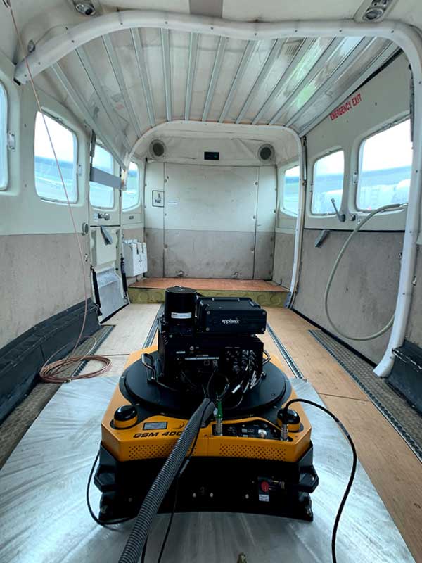
Atlantic — a remote sensing, surveying and consulting business — has purchased a Phase One Industrial 280MP large-format aerial solution to better serve its clients. The upgrade substantially increases Atlantic’s ability to efficiently capture a large area with extreme accuracy and quality.
Photo: Phase One Industrial
The massive Phase One Industrial 280MP aerial solution is a large-format camera system that easily integrates with smaller gyro-stabilized mounts creating a compact d lightweight system for use in a wide range of aircraft.
At its heart, the iXM-RS 280F is a dual-lens metric camera, with 90mm lenses for capturing RGB information, adding a near infrared (NIR) camera generates a four-band configuration, useful in agriculture, forestry and pipeline monitoring missions.
The iXM-RS280F camera has an image coverage width of more than 20,000 pixels whilst the cameras’ backside illuminated CMOS sensor supports very high dynamic range at 83dB. Its high light sensitivity provides superb image quality in challenging low light conditions, enabling operators to take advantage of more flight hours per day and more flight days per year.
“We’ve been using Phase One’s camera technology for over two years combined with our Optech lidar systems,” said Brian Mayfield, president and CEO of Atlantic. “We are very impressed with the technology and applaud Phase One’s innovative approach to designing a high-quality large format camera that produces exceptional results. The Phase One 280MP is yet another forward-looking technology resource that we’ve added to provide the most complete and cost-effective geospatial solutions for our clients.”
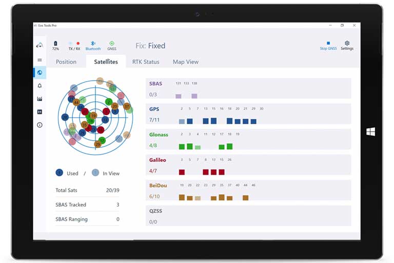
Eos Tools Pro implements powerful new features that enables users to exploit all four global GNSS constellations and a state-of-the-art NTRIP client to access real-time kinematic (RTK) bases and RTK networks all over the world via NTRIP, Direct IP and wireless radios.
“This is a huge step forward in functionality and flexibility for our Windows users,” said Jean-Yves Lauture, CTO of Eos. “We implemented the latest support for Windows Geolocation and other features offered by Microsoft in order to allow our customers to use high-accuracy locations directly into their apps.”
Eos Tools Pro includes new features for both field professionals and application developers.
For field professionals
RTK network/RTK base connectivity. Eos Tools Pro implements state-of-the-art NTRIP connectivity to connect to any RTK network or RTK base in the world. For geographic areas without cellular coverage, Eos Tools Pro supports Bluetooth wireless radios (UHF/VHF, etc.) for base/rover connectivity.
The software supports all new BeiDou and Galileo satellites in addition to GPS and GLONASS as well as SafeRTK functionality for areas with marginal cellular coverage.
Eos Tools Pro for Windows shows all current satellites in use from GNSS constellations such as GPS, Galileo, BeiDou, GLONASS and QZSS. (Screenshot: Eos Positioning)
Geoid models. Eos Tools Pro implements the latest geoid models for many regions in the world, providing survey-grade orthometric heights directly into any Windows applications.
Datum shift. Eos Tools Pro adds a new feature to apply a simple X, Y, Z shift to the current location to match any local datum.
Alarms. A vast number of audible alarms can be set to warn the user if parameters such as estimated accuracy, differential status, correction age, Bluetooth connectivity, are not met.
For Windows developers
Geolocation/Sensor API. Eos Tools Pro supports apps that rely on the Windows geolocation service to retrieve accurate latitude, longitude and altitude from their Arrow receiver. In addition, the Sensor API allows programmers to access the wide array of GNSS metadata while removing the laborious task of parsing NMEA data.
Virtual COM port and TCP/IP server. Eos Tools Pro features a built-in duo of virtual COM port and TCP/IP server to output streams of standard NMEA sentences. This enables multiple apps capable of parsing NMEA messages to have simultaneous access to the Arrow GNSS location and metadata.
“Eos Tools Pro for Windows enables users and developers to benefit from our leading-edge, high-accuracy GNSS receivers,” Lauture said. “When Windows tablets are the device of choice among our customers, the combination of Eos Tools Pro and Arrow GNSS receivers provide the absolute latest GNSS technology for GIS, engineering, construction, and surveying users. When Windows tablets are the device of choice among our customers, the combination of Eos Tools Pro and Arrow GNSS receivers provide the absolute latest GNSS technology for GIS, engineering, construction and surveying users.”
Eos Tools Pro for Windows is available for free to users of Arrow GPS and GNSS receivers. It is compatible with any Windows 10 desktop, laptop or tablet computer via Bluetooth or USB.
Latest inertial navigation system serves new customer requirements in autonomous vehicles, mobile mapping, surveying and more
Photo: Honeywell
Honeywell is introducing the HGuide n380, an inertial navigation system (INS) that communicates position, orientation and velocity of an object — such as an autonomous vehicle or unmanned aerial vehicle (UAV) — even when global navigation satellite signals are unavailable.
Smaller, lighter and lower priced than previous Honeywell inertial navigation systems, the HGuide n380 is built using Honeywell’s rigorous design standards to withstand harsh environments in the air, on land or at sea.
“We recognized a need for a small, high-performance inertial navigation system in areas like 3D mapping, surveying and other applications where space is at a premium and performance cannot be compromised,” said Chris Lund, offering management senior director, Navigation and Sensors, Honeywell Aerospace. “We responded by developing the HGuide n380 inertial navigation system, which provides our customers with proven, cost effective inertial sensor technology, created for aerospace applications, but that can be integrated into almost any architecture.”
The new inertial navigation system is composed of Honeywell’s HGuide i300 inertial measurement unit (IMU), a GNSS receiver and Honeywell’s proprietary sensor-fusion software, which is based on the algorithms used for navigation on millions of aircraft every day.
Inputs from these components are fused together to determine position, orientation and velocity to deliver critical navigation information even in areas where a satellite signal is degraded or altogether unavailable, such as canyons, bridges, tunnels, mountains, parking garages or dense forests.
“As the industry evolves, Honeywell’s HGuide suite of IMUs and navigators will be a key enabler of emerging segments like autonomous vehicles, mobile mapping, precision agriculture, robotics and surveying,” Lund said.
During its development, the new product was placed in extreme environments to test ruggedness and was exposed to extensive factory calibration and compensation procedures that help ensure measurement accuracy and performance.
Honeywell has extensive experience in designing and building high-end inertial sensor and navigation systems and has used that expertise to develop a lower-cost portfolio of HGuide offerings to serve new markets and customer requirements.
To date, Honeywell has delivered more than half a million high-performance inertial sensors to serve as navigation aids on an extensive list of manned and unmanned vehicles, which include many air and spacecraft in use today.
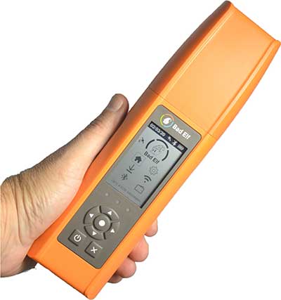
Bad Elf LLC has completed transition of all Bad Elf Flex receivers to the Hemisphere GNSS Phantom OEM module.
Photo: Bad Elf
As one of the first partners to incorporate the Phantom, Bad Elf Flex offers significantly enhanced capabilities and further exemplifies the company’s commitment to future-ready GNSS designs.
“We tested the Phantom OEM modules extensively, and confirmed they deliver the promised power savings and performance improvements when integrated with the Bad Elf Flex,” said Larry Fox, Bad Elf’s vice president of marketing and business development. “Hemisphere’s technology allows us to democratize GNSS through Bad Elf Flex.”
The new Phantom modules deliver a 30% gain in battery life, superior performance and scalable access to every GNSS constellation and signal, including GPS, Galileo, GLONASS, BeiDou, QZSS, IRNSS, SBAS and Hemisphere’s Atlas L-band, Fox said.
Photo: Hemisphere GNSS
Bad Elf Flex is a scalable-accuracy GNSS receiver with a daily option to choose between L-band and real-time kinematic (RTK). In standard configuration, it achieves 30-60 cm accuracy in real-time for GIS use.
Consuming a Bad Elf Flex Token unlocks a full RTK workflow for a 24-hour period to deliver 1-cm horizontal accuracy. Bad Elf Flex stores the tokens directly on the receiver, making them available for use anytime and anywhere. Customers requiring high accuracy at all times can purchase the Bad Elf Flex Extreme bundle, with RTK capabilities permanently unlocked, for a one-time upgrade fee.
Surveyors and their crews now have a scalable-accuracy, survey-grade receiver. GIS managers can focus on flexible field choices for work crews with varying skill levels. Bad Elf Flex falls within most capital expense budgets, allowing businesses to obtain operational and financial efficiencies.
“Bad Elf saw an opportunity to offer the GIS community a product lineup with better than 3-meter accuracy for under $3,000,” said John Cunningham, Bad Elf’s chief executive officer. “We began three years ago with our 2-meter ($300) and 1-meter ($600) mapping-grade product offerings. Our customers continued asking us to address the 50 cm, 10 cm and 1 cm requirements for their businesses. We worked hard over the past two years to build a platform, Bad Elf Flex ($3,000), that addresses these needs without breaking budgets. We have a solution that works today and provides a foundation to meet future customer requests. We love learning from our customers and look forward to continuing this conversation and extending high-accuracy GNSS for all.”
“Hemisphere is excited that Bad Elf’s Flex series now features our latest generation GNSS receiver,” said Miles Ware, director of marketing at Hemisphere. “We believe the scalable accuracy option made possible by our high-performance Atlas L-band correction service will be a game-changer in their served markets.”
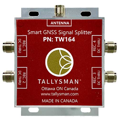
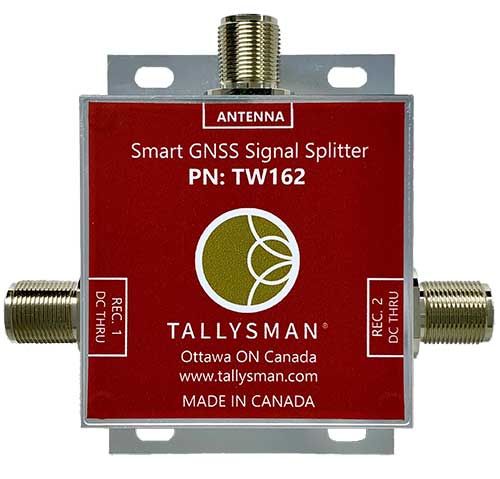
Tallysman Wireless Inc. has added two new models to its line of GNSS helical antennas.
Also new are two GNSS signal splitters.
New Helical Antennas
HC976 triple-band helical antenna with L-band, embedded version. (Photo: Tallysman)
The HC976 housed and HC976E embedded helical antennas are designed and crafted for high-accuracy positioning in a light and compact form factor, making them suitable for many applications:
autonomous vehicle navigation (land, sea and air)
handheld land survey devices
automotive positioning
GNSS timing
Both models support GPS/QZSS-L1/L2/L6, GLONASS-G1/G2, Galileo-E1/E6, and BeiDou-B1/B3 frequency bands.
Regional augmentation services supported include:
WAAS (North America)
EGNOS (Europe)
MSAS (Japan)
GAGAN (India)
high-precision L-band correction services
The key feature of the HC976 and HC976E is the support of QZSS-L6, Galileo-E6 and BeiDou-B3.
The HC976 is 44 millimeters (mm) wide and 62 mm tall, weighing only 42 grams.
HC976 triple-band helical antenna with L-band, housed version. (Photo: Tallysman)
It features a precision-tuned helical element that provides an excellent axial ratio and operates without the requirement of a ground plane, making it suitable for a wide variety of high-precision applications.
The HC976 also features a low-current, low-noise amplifier (LNA) and pre-filter to prevent harmonic interference from high-amplitude signals, such as 700 MHz band LTE and other nearby in-band cellular signals.
All Tallysman’s housed helical antennas are enclosed in a robust military-grade plastic enclosure. The antenna base has an integrated SMA connector, a waterproofing O-ring and three screw holes to enable secure attachment.
Weighing only 12g and measuring 39mm wide and 50mm tall, the lightweight HC976E embedded antenna supports all the features of the HC976. To facilitate installation of the HC976E, Tallysman provides an optional embedded helical mounting ring, which traps the outer edge of the antenna circuit board to the host circuit board or to any flat surface.
Tallysman also provides support for installation and integration of embedded helical antennas to enable successful implementation and to provide optimal antenna performance.
New GNSS Splitters
Photo: Tallysman
Tallysman’s two new Smart Power GNSS signal splitters improve GNSS service reliability.
GNSS is a critical component in safety, security, timing, and infrastructure applications, all of which require very high availability. Tallysman provides resilient, fault-tolerant Smart Power GNSS signal splitters that are essential to minimize service interruptions.
The design of first-generation GNSS signal splitters suffered from a single point of failure: only one attached receiver powered the splitter and the antenna. If this receiver failed or was unplugged, all attached receivers also failed.
Tallysman’s current-generation Smart Power GNSS signal splitters, TW162 (one antenna/two receivers) and TW164 (one antenna/four receivers), offer system redundancy and fail-over capability.
Photo: Tallysman
First, the splitter accepts power from all attached GNSS receivers; if one receiver fails, the next attached receiver automatically provides power to the splitter and antenna.
Second, if the antenna fails and does not draw current, it will provide the receiver powering the splitter with a current draw lower than 1 mA, indicating an antenna fault.
The Tallysman TW162 and the TW164 are professional-grade GNSS signal splitters that support the full GNSS spectrum: GPS/QZSS-L1/L2/L5, QZSS-L6, GLONASS-G1/G2/G3, Galileo-E1/E5a/E5b/E6, BeiDou-B1/B2/B2a/B3 and L-band correction service frequency band.
The TW162 and TW164 are packaged in a robust, compact, lightweight, and waterproof (IP67) corrosion-protected aluminum housing. They splitters are available with either TNC or type-N connectors. Two gain options are available: standard gain to compensate for signal-splitting loss and 10-dB gain.
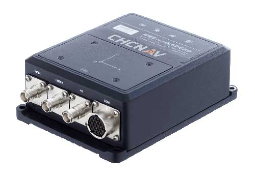
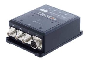
CHC Navigation has released the new CGI-610 GNSS/INS sensor, a high-precision dual-antenna receiver offering reliable and accurate navigation and positioning solutions for demanding land, marine and aerial applications.
The tight fusion of the latest GNSS technology with an industrial-grade MEMS IMU is powered by CHCNAV’s algorithms to deliver accurate hybrid position, attitude and velocity data, even in complex and obstructed environments where GNSS outages can occur.
The CGI-610 is a powerful GNSS/INS system supporting data output up to 100 Hz to meet the requirements of highly dynamic applications (including airplane, train and automobile). The optional external odometer sensor for ground vehicles can provide an additional independent measurement of displacement and speed, which is fused with the GNSS/INS navigation solution.
“The CGI-610 GNSS/INS sensor is the perfect answer to the growing demand of robust positioning and navigation systems for the control of any unmanned vehicle and machine, as well as for highly dynamic applications,” said George Zhao, CEO of CHC Navigation. “Industrial system integrators in need of a reliable GNSS/INS sensor with an exceptional price/performance ratio would definitely consider our CGI-610.”
With its 4G modem, CAN and serial ports, the CGI-610 GNSS/INS sensor offers unparalleled compatibility to enable a wide range of applications including machine control, port automation, advanced trajectography, robotics and unmanned vehicles. The CGI-610’s industrial design ensures reliable and consistent operation in the harshest environments.
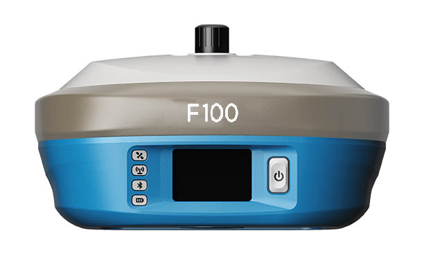
Geneq Inc.’s new F100 GNSS receiver, an upgrade to the F90, is designed to meet surveyors’ demands for high field performance, flexibility and cost-effectiveness.
The F100 tracks multiple constellations (GPS, GLONASS, Galileo, Beidou) and can maximize the acquisition and tracking process with all-in-view GNSS frequencies.
Another important feature from the F100 is the 1.45-inch color LCD display with a multi-touch capacitive screen. It has 32GB of internal memory. Its integrated second-generation web user interface control is compatible with all devices and all browsers.
Photo: Geneq
Providing maximum performance for accuracy and real-time measurements, F100 also supports real-time kinematic (RTK) correction services, including the RTX service that can get centimeter-level accuracy without a base station. The F100, with its advanced technology, ensures high performance even in difficult environments such as under heavy canopy.
The F100 has an excellent combination of GNSS, 4G, Bluetooth and Wi-Fi antenna. The innovative F100 has a built-in 5-watt radio that enables an effective baseline of 10 kilometers.
Its shorter charging time and a battery of 13600-mAh capacity enable long hours in the field. Even with its magnesium alloy casing, F100 weighs only 1.5 kg and measures 154 x 154 x 76 millimeters. Mobile field workers will find in this feature an ally to their surveying productivity.
With its integrated high-sensitive E-bubble and new tilt survey algorithm, the F100 becomes a calibration-free GNSS receiver. Immune to magnetic disturbance and free from limitation of tilt angles, the F100 can be used to measure unreachable points.
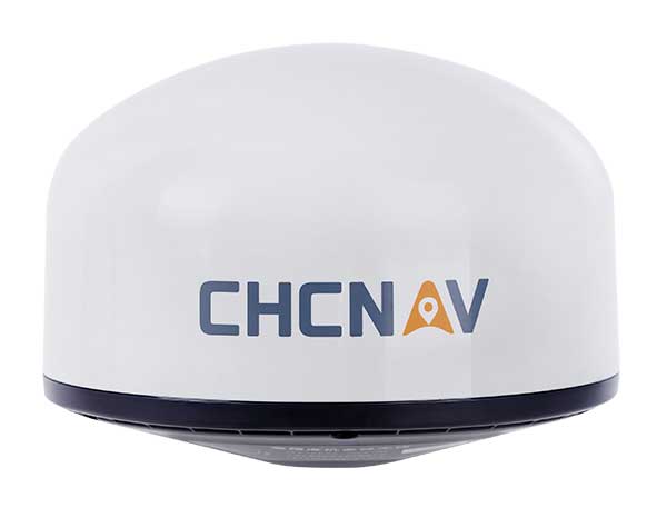
Designed for GNSS networks and monitoring applications
Photo: CHC Navigation
The AT661 geodetic antenna for GNSS networks or monitoring applications supports all current and future GNSS signals, including GPS, GLONASS, BeiDou, Galileo, QZSS, IRNSS, SBAS and L-band. The antenna features both high-gain LNA and wide beamwidth to provide excellent flexibility in applications requiring low-elevation satellite reception and high availability of GNSS signals, especially in obstructed situations. The accuracy of the antenna’s phase center reaches the millimeter level with extremely high stability and repeatability to ensure perfect processing of GNSS data regardless of the length of the baselines. The AT661 withstands all types of weather, including large temperature fluctuations, and is protected by a waterproof radome.
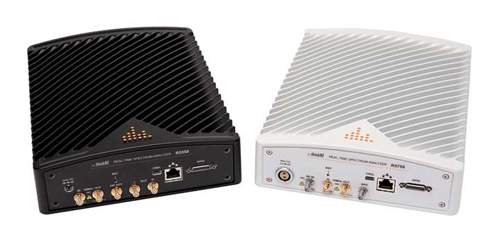
The ThinkRF R5750 Real-Time Spectrum Analyzer with GPS offers high spectral performance, low power consumption, and portability. The R5750 analyzer is built for outdoor, mobile and distributed deployment scenarios, including regulatory and intelligence monitoring, telecom deployment optimization, and RF application development. Users can deploy units in a variety of network architectures, analyze signals in real-time or later, and easily integrate with leading software applications to conduct demodulation or deeper analysis of signals up to 27 GHz. The R5750 analyzer includes embedded GPS for time and location data, and comes with an optional IP66 rating for increased durability and ruggedness in difficult environments.
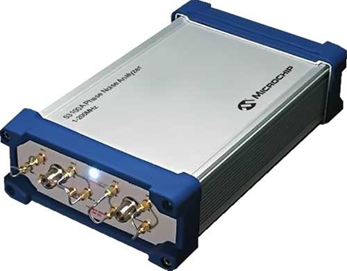
The 53100A Phase Noise Analyzer takes precise and accurate measurements of frequency signals, including those generated by atomic clocks and other high-performance frequency reference modules and subsystems. It combines timing technologies in a small, high-performance measurement instrument designed for engineers and scientists who rely on precise and accurate measurement of frequency signals generated for 5G networks, data centers, commercial and military aircraft systems, space vehicles, communication satellites and metrology applications. Up to three separate devices can be tested simultaneously using a single reference, enabling higher capacity for stability measurements.
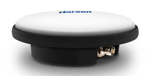
The IP69K ruggedized HX-CVX600A antenna provides end users with millimeter accuracy, durability and productivity. The antenna is designed for applications subject to high shock and vibration environments such as machine control. Integrated with reliable signal tracking and strong anti-interference performance, the Harxon HX-CVX600A offers full support for reliable and consistent satellite signal tracking, including GPS, GLONASS, Galileo, BeiDou, QZSS, IRNSS and SBAS, as well as L-band correction services. Its stable phase center adopts multipoint feeding technology, exceptional low-elevation satellite tracking with symmetric radiation patterns, high gain with ultra-low signal loss, as well as outstanding wide-angle circular polarization. The aerodynamic enclosure withstands exposure against dust, rain, splash or sunlight.
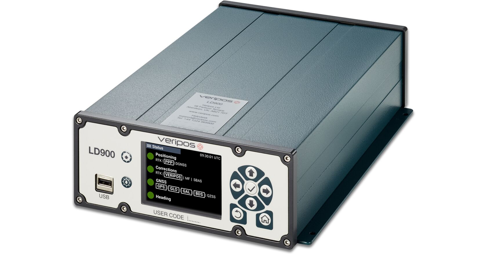
The LD900 is a quad-band GNSS receiver capable of tracking GPS, GLONASS, BeiDou, Galileo and QZSS constellations to provide reliable and accurate positioning. The LD900 also receives L-band signals on multiple channels, providing access to Veripos’ worldwide independent correction services. Using the independent L-band RF input on the LD900 allows the connection of a dedicated L-band antenna ensuring optimal reception of correction services, especially at high latitudes. Veripos provides accurate and reliable positioning for all marine applications via their redundant positioning and multi-frequency precise point positioning (PPP) Apex and Ultra services. The Apex5 correction service utilizes all GNSS constellations delivering 5cm positioning accuracy for use in the most demanding offshore applications. Real-time kinematic (RTK) corrections can be utilized by the LD900 for applications where this service is required. The intuitive color display and navigation menu makes setup, configuration and system status monitoring simple. The display also helps troubleshoot issues with the LD900, allowing faults to be quickly diagnosed and resolved. The LD900 can also be configured remotely through the Veripos Quantum software.
The edge-to-cloud IoT platform Particle is offering a new tracking system that allows organizations to track the locations of a wide variety of mobile assets. Particle’s Tracker system-on-module (SoM) provides a powerful GNSS, microcontroller and advanced peripherals in a compact form factor. Tracker SoM serves as a starting point for organizations that require a tailored tracking solution for sophisticated applications, as well as a fully certified foundation for OEMs developing commercial products. All of the company’s tracking solutions come with a high-gain GNSS antenna accurate to 1.8 meters. The field-ready solution is configurable and can track the real-time location of critical assets and capture additional intelligence via sensor data including temperature and acceleration as well as remotely controlled mobile equipment and vehicles.
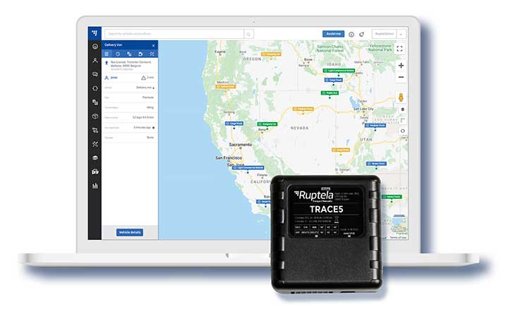
Designed in Europe, now available in North America
Photo: Ruptela
The Trace 5 plug-and-play GPS-based automatic vehicle location (AVL) tracker and multifunctional fleet management platform TrustTrack provide a ready-to-use telematics solution. The Trace 5 GPS tracker has LTE Cat M1 (4G) connectivity and an integrated battery. TrustTrack is an advanced telematics platform for businesses to manage transport resources. It connects dispatchers and drivers and enables real-time monitoring and drivers’ management. It also generates trip reports.
The HawkEye 5500 is the a dual-mode real-time tracking and vehicle management system that supports Iridium, GPS and 2G/3G/LTE. A GNSS/Iridium antenna is included in the kit. The HawkEye 5500 offers full integration of on-board systems, support for both light and heavy-duty vehicles, two-way messaging, a remote emergency switch, collision detection, audible alerts, RFID and Bluetooth driver identification and customizable application integration. It provides global always-on coverage with high-resolution tracking and communication. Users can customize reporting rates based on movement or location and provide driver feedback when safety violations occur. All operations are tracked via Blue Sky Network’s portal, SkyRouter, which allows for effective high-security command and control of fleets anywhere on the planet.
For infrastructure, mining, forestry, construction
Photo: Kaarta
The Stencil Pro, now in beta testing, is a professional-grade mobile mapping platform with dimensional and visual fidelity. The all-in-one system can scan, process and view captured data in real time. It offers panoramic high-definition 4K imagery and colorized point clouds, and is optimized for both indoor and outdoor lighting. Its simultaneous localization and mapping (SLAM) capabilities enable it to operate in GNSS-denied areas such as indoor, underground, under thick canopy, or in urban canyons. However, it is also fully geo-enabled with an integrated Trimble BD-990 receiver, AV-28 antenna and a range of other third-party GNSS antennas. It supports accuracy enhancements through live RTK/NTRIP processing as well as PPK corrections. GNSS positioning data is used to align and geo-register data for accuracy. The onboard GNSS and color cameras are fully integrated into real-time capture. If a colorized point cloud is not required, or GNSS is not available, reliance on other sensors is seamless.
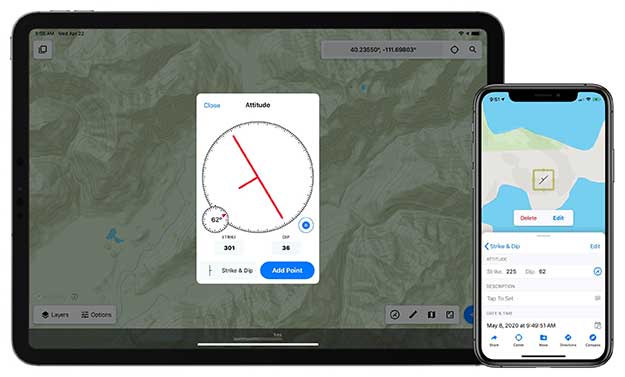
Touch GIS is a powerful mobile app for field data collection and visualization. Version 1.3 features a digital clinometer to assist field geologists in recording strike and dip readings as well as a new attitude attribute type, which makes it easy to record and display these readings on the map. Touch GIS has powerful file support for industry-standard types, offline mapping capabilities, and accurate drawing tools for points, lines and polygons.
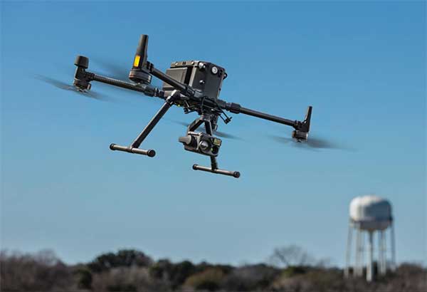
For precise aerial inspections and data collection
The Matrice 300 RTK UAV. (Photo: DJI)
The Matrice 300 RTK is DJI’s most advanced commercial drone platform to date. It integrates modern aviation features, advanced artificial intelligence capabilities, a six-directional sensing and positioning system and a UAV health management system. It has 55 minutes of flight time. The drone platform has AES-256 encryption and an IP45 weather-resistant enclosure. A built-in all-new OcuSync Enterprise transmission system provides a triple-channel 1080p video transmission signal reaching up to 15 kilometers away. The M300 RTK can support up to three payloads simultaneously and up to a total payload capability of 2.7 kg.
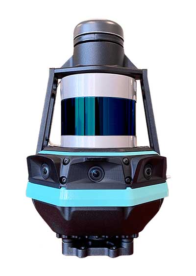
Robust positioning in demanding industrial environments
Photo: Septentrio
The AsteRx-i D UAS combines centimeter-level positioning with 3D orientation, enabling automated navigation of aerial drones and robots. It is compact and lightweight, with a high-performance inertial measurement unit from Analog Devices integrated directly into the receiver board. Its small form-factor combined with exceptionally low power consumption results in extended battery life and longer flight times. Both single-antenna and dual-antenna versions are available. The single-antenna version provides a lightweight solution optimizing the system size, weight and power (SWaP). The dual-antenna version is designed for machines that need reliable heading from the start.
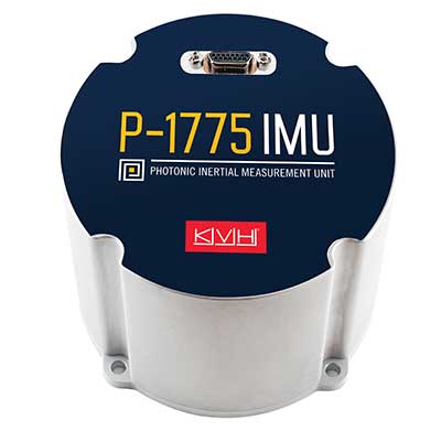
New patented PIC Inside technology is designed to enhance inertial sensor performance and reliability for the growing autonomous market
Photo: KVH
KVH Industries has launched the P-1775 inertial measurement unit (IMU), featuring KVH’s new PIC Inside photonic integrated chip (PIC) technology.
KVH has been developing and testing the technology for more than three years and is now incorporating it into existing product lines. The first units have started shipping.
One of the first customers has integrated the P-1775 IMU into its next-generation rocket launch vehicle.
KVH’s PIC Inside technology features an integrated planar optical chip that replaces individual fiber-optic components to simplify production while maintaining or improving accuracy and performance.
The PIC Inside product is designed to deliver 20 times higher accuracy than less expensive MEMS inertial measurement units, uses modular designs for ease of integration, and has outstanding repeatability unit-to-unit.
“I applaud the tremendous effort by our incredible engineers in developing this groundbreaking technology and I am thrilled that we have begun to incorporate PIC Inside technology into our existing products, a process that we expect to continue throughout the year,” said Martin Kits van Heyningen, KVH CEO.
The PIC technology will be added to KVH’s inertial sensor product line for use across a broad range of applications from navigation to stabilization and pointing. KVH’s fiber-optic gyros (FOGs) and FOG-based products are particularly well-suited for the large and growing autonomous market. This market includes applications on land, sea and air, such as drones, people movers, trucks, and mining and construction equipment.
Autonomous applications rely on high-quality inertial sensors to deliver an extremely accurate navigation solution, delivering the performance required in critical metrics such as angle random walk (ARW) and bias instability.
Next-generation driverless cars, which require centimeter-level precision for safety, are the ideal application for KVH’s inertial products, KVH said. Employing the PIC design allows for a lower cost and scalable solution due to the elimination of various fiber components and a reduction of labor.
In 2019, KVH delivered its first product prototypes containing PIC technology to automotive customers and presented the science behind the technology to an audience of engineers at an inertial sensor conference, describing the extensive development, testing, and benefits of the new technology.
KVH is a leading innovator for assured navigation and autonomous accuracy using high-performance sensors and integrated inertial systems. KVH’s widely fielded TACNAV systems are in use by the U.S. Army and Marine Corps as well as many allied militaries around the world. KVH’s FOGs and FOG-based IMUs are in use today in a wide variety of applications ranging from optical, antenna and sensor stabilization systems to mobile mapping solutions and autonomous platforms and cars.