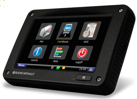
Rand McNally has announced a new pricing plan, new features, and a new warranty program for its single-box compliance solution for fleets. The TND 760 Fleet Edition is a next-generation in-cab electronic on-board recorder (EOBR) device that installs in less than 30 minutes, is low cost, and is easily adopted by drivers, the company said.
For as little as $649 for the hardware, and $19.95 per month for service, trucks can be equipped with a fully compliant EOBR solution. For $799, the device also comes loaded with Rand McNally’s navigation. Lease options are available for as low as $39 per month for qualifying fleets.
Among the new items announced today, three monthly service plan options are now available. The EOBR plan, offering electronic hours of service and vehicle inspection reporting, for $19.95/month; the Basic plan, which layers on vehicle positioning and online mapping, text and form messages, driver email and attachments, as well as integration access via Rand McNally Connect, for $29.95; and the full Enterprise plan that layers on a driver scorecard, vehicle performance, critical event reporting and vehicle maintenance, for $39.95. These service plan prices are based on a three-year commitment.
A three-year warranty is now standard on the TND 760 hardware, providing customers peace of mind for the term of the agreement that their hardware is covered under warranty. This is an upgrade from the standard one-year warranty typically offered in the industry.
And, Rand McNally announced a group of new features coming on stream in the next few months. By the end of June, a new back-end mapping portal with upgraded geofencing, alerting, and route replay will be up and running. This feature will be part of the Basic and Enterprise monthly plans. Also in development are significant enhancements to the IntelliRoute TND GPS navigation software, including the ability for fleets to send, and for drivers to receive, routes on the TND 760.
“As we roll out the TND 760 to more fleets and transportation companies, we’re finding that there are a number of items they’re responding to,” said Dave Muscatel, CEO of Rand McNally. “The low cost, the quick installation, and the fact that Rand McNally is well regarded among professional drivers is key. When drivers accept the device, they use it.”
The Rand McNally TND 760, Fleet Edition, first available Q4 of 2011, integrates with a truck’s on-board computer and sends and receives information via both Wi-Fi and cellular modes. The TND 760, manufactured in the U.S.A., is designed to be set up in less than 30 minutes and does not require the installation of a separate “black box” monitoring unit like traditional mobile communication systems.
Despite its compact design, the TND 760 features a broad array of capabilities including fleet communications via email, driver and vehicle performance monitoring, electronic hours of service (HOS) compliance, and truck-specific navigation. Information on fleet activity is managed via Rand McNally’s significantly enhanced FleetWatcher web-based portal.
For more information and product demonstrations, potential customers should call 1-800-641-RAND (7263) or go to randmcnally.com/tnd760.
Several new rugged GPS-enabled devices were announced this week.
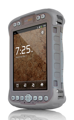
Juniper Systems has partnered with Pennsylvania-based SDG Systems to market the Mesa Rugged Notepad with Android (AOSP) 2.3 operating system, a rugged handheld computer known as the RAMPAGE 6 and distributed through SDG Systems. Availability of the RAMPAGE 6 is scheduled for the third quarter of 2012 and its first public presentation will be at the Esri International User Conference in San Diego, July 23–27, 2012.
The Android (AOSP) 2.3 operating system on the RAMPAGE 6 offers many advantages for data collection, including easy multi-tasking, a modern user interface, rich programming environment, multi-platform development, abundant application data storage, open source flexibility, and the opportunity for a custom Android interface developed by SDG Systems, according to Juniper Systems. Additionally, its optional kiosk mode allows only certain applications to be accessible by the user, creating a single-purpose device without distractions, Juniper Systems said.
The RAMPAGE 6 will have the same features as the Mesa Rugged Notepad, including a large 5.7-inch viewing display, IP67 ingress protection rating for water and dust, integrated 2–5 meter GPS receiver, optional integration of a 1D/2D barcode scanner, and optional Class I, Division 2 certification for use in hazardous locations.
Meanwhile, DRS Technologies, Inc., announced today that its Tactical Systems division has expanded its product portfolio with three new ARMOR rugged tablets. The ARMOR X7et and the ARMOR X7ad are thin, lightweight tablets based on customers requesting even more portable computers from ARMOR, the company said. “The 7-inch multi-touch tablets shatter the perception of bulky, rugged computing, and offer field service workforces the ability to choose between the fast-growing Android OS and the enterprise-friendly Microsoft Windows platform,” The company said. Additionally, DRS is now offering a new light convertible tablet, the ARMOR X12kb, that meets MIL-STD-810G. All three follow introduction of the ARMOR X7 compact rugged tablet launched in 2011.
The ARMOR X7et is a Windows-based tablet that weighs less than 1.5 pounds and provides six hours of battery life. It features an Intel Atom Z670 processor and runs Microsoft Windows 7 Professional. Its Android counterpart, the ARMOR X7ad, weighs 1.3 pounds and operates for up to eight hours. It features a NVIDIA Tegra 2, 1.0-Ghz dual-core processor, and operates on Android v3.2. Both lightweight tablets feature a 7-inch outdoor-readable multi-touch screen display. They are certified to MIL-STD 810G for extremes in temperature, vibration, shock, and four-foot drops and have an IP65 rating for ingress protection, which means they are fully protected against dust and can withstand low pressure jets of water from all directions.
Weighing 5.5 pounds, the ARMOR X12kb features a 12.1-inch sunlight-readable swivel touchscreen that incorporates polarized LCD glass and anti-reflective technology. The ARMOR X12kb offers the Intel Core i5-560UMCPU processor and runs Microsoft Windows 7 Professional. It has a long battery life, operating for up to eight hours, as well as a spill-proof keyboard and touchpad. Additionally, the one-click stealth mode operation disables all emitting light and sounds, a feature designed for the unique applications of covert operations.
The three new ARMOR mobile computers include connectivity options including Gobi Wireless Broadband, integrated GPS, 802.11 b/g/n Wi-Fi, and Bluetooth wireless. They are designed to make it easier for workers to use mobile computing in rugged environments, as this product video shows:
Juniper Systems announced the Mesa Rugged Notepad with Android (AOSP) 2.3 operating system. In a partnership with Pennsylvania-based SDG Systems, the RAMPAGE 6 will be distributed exclusively through SDG Systems.
“Our new partnership with SDG Systems will further enhance our ability to provide the best rugged handheld computing solutions to our customers. By working together, we have created a very unique and in-demand handheld computer with the Android (AOSP) operating system, now known as the RAMPAGE 6,” said Rob Campbell, President and CEO of Juniper Systems. “Leveraging the Android expertise of SDG gives our customers an original and powerful data collection device and we couldn’t be more excited about the opportunities this new partnership will bring.”
According to the announcement, the Android (AOSP) 2.3 operating system on the RAMPAGE 6 offers many advantages for data collection, including easy multi-tasking, a modern user interface, rich programming environment, multi-platform development, abundant application data storage, open source flexibility, and the opportunity for a custom Android interface developed by SDG Systems. Additionally, its optional kiosk mode allows only certain applications to be accessible by the user, successfully creating a single-purpose device without distractions.
“SDG Systems is proud to develop and distribute the RAMPAGE 6 as our very first SDG-branded handheld computer. Collaborating with Juniper Systems on a product as unique and dependable as the Mesa Rugged Notepad has made this experience very rewarding and we’re excited to put the SDG name on it. Our decision to develop Android (AOSP) for the Mesa was based on its extreme ruggedness, quality design, and dependability. I am confident that the RAMPAGE 6 will live up to those standards,” said Todd Blumer, President and CEO of SDG Systems.
Juniper reports that the RAMPAGE 6 will feature the many advantages and benefits of the Mesa Rugged Notepad, including a large 5.7 inch viewing display, IP67 ingress protection rating for water and dust, integrated 2–5 meter GPS receiver, optional integration of a 1D/2D barcode scanner, and optional Class I, Division 2 certification for use in hazardous locations.
Availability of the RAMPAGE 6 is scheduled for the third quarter of 2012 and its first public presentation will be at the Esri International User Conference in San Diego, July 23–27, 2012.
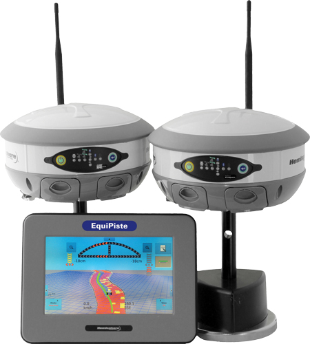
Hemisphere GPS has announced the EquiPiste integrated snow grooming management system. EquiPiste provides visual guidance, snow depth status, and event logging for snow grooming operators, mountain managers and snow road operations. Ski resorts benefit from improved grooming quality and productivity, optimal snow making decisions and distribution, as well as more predictable and preventative snow cat maintenance, according to Hemisphere GPS.
Snow grooming operations are tasked with creating quality snow conditions for ski trails or pistes, as they are referred to in the industry. Designed with an integrated touchscreen terminal and Crescent GPS, Hemisphere GPS’ EquiPiste graphically displays to the operator the areas groomed, boundaries, assets, points of interest, and hazards. Through the guidance cues, operators increase their efficiency and quality of work by avoiding overlaps and skips in grooming, Hemisphere GPS said. Areas that need attention such as thin snow pack and winch anchors can be flagged with meta-data so operators can easily navigate back at any time, even in low visibility. Pathways can be mapped and re-used for training novice operators or for repeatedly navigating snow roads. Operation managers benefit from reviewing the job files from each machine to determine variable costs, performance and maintenance tracking, the company said. As well, data can be mapped within Google Earth and used for generating daily grooming or road maintenance reports for customers.
Many ski resorts also spend a substantial amount of their budget on snow making activities. When combined with Hemisphere GPS’ survey grade Eclipse GNSS technology, EquiPiste displays and records real-time snow depth measurements and maps, the company said. The snow depth data improves the efficiency and quality of managing the snow levels. The depth data helps indicate where and when to make snow, it alerts the operator to thin snow pack, where to redistribute snow as well as how to identically recreate (day to day and year to year) downhill race courses. Analysis of the snow depth data enables more optimized snow management.
“Through collaboration with the ski resort and snow vehicle machine industry we have customized existing Hemisphere GPS technology to serve an adjacent vertical market,” said Andre Roberge, senior manager of New Ventures at Hemisphere GPS. “EquiPiste is truly a comprehensive snow management system that allows ski and snow road operations to capture and visualize the status and behaviour of snow for optimized grooming and manufacturing. Our customers have experienced tremendous benefits in productivity, quality, and safety as well as significantly reduced operational expenditures and lowered environmental impact. As a result, EquiPiste customers are able to provide a better standard of service and experience to their customers.”
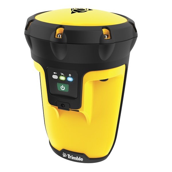
Trimble introduced today the next-generation of its Trimble GPS Pathfinder family — the Trimble Pro 6H and Pro 6T receivers for GIS and mobile mapping. The Trimble Pro series with advanced features allows mobile workers to configure a solution for a wide range of applications, delivering flexibility in professional GIS data collection, Trimble said. The series offers a new streamlined form-factor and dramatic productivity improvements in difficult GNSS environments with Trimble Floodlight technology.
The modular Trimble Pro series receiver gives users the flexibility to choose their setup configurations:
Optimized for use with Trimble data collection devices such as the Trimble Juno or Nomad G series handhelds, or Yuma tablet computer, the Trimble Pro series can also be used with other tablets and handhelds with NMEA output.
Real-time or postprocessed GIS workflows.
The receiver can be deployed in a backpack, on a pole or mounted on a vehicle.
Two models are available: the Trimble Pro 6H delivers decimeter accuracy, while the Pro 6T is the submeter model for standard GIS applications.
With the availability of the new Pro series receivers, data collection professionals now have access to the productivity-enhancements of Floodlight technology in both integrated and modular configurations,” said Daniel Wallace, general manager of Trimble’s GIS Data Collection Division. “While some prefer the convenience of an integrated, all-in-one handheld, others will appreciate the Pro series’ flexibility to choose from a range of data collection devices such as a high-resolution tablet or lightweight Trimble Juno.”
Trimble Floodlight technology allows users to collect decimeter accuracy data in tough GNSS environments, Trimble said. Buildings and trees can cause satellite shadow and limit the environments where high-accuracy GNSS data collection can be performed. Trimble Floodlight technology combines a range of techniques to increase the availability of positions and boost accuracy in areas affected by satellite shadow. Using Floodlight technology, the Pro series can keep teams productive without compromising on accuracy. Users can work with fewer disruptions and ensure better data, faster data collection and higher field efficiency.
Trimble Pro series receivers are rugged and built to withstand the rigors of long hours in tough outdoor conditions, yet optimized for high-accuracy GIS data collection workflows, Trimble said. For applications such as utilities inspections and timber stand valuations, Trimble Pro receivers provide long battery life and tough construction for dependable service over the course of rigorous data-collection projects.
With its IP65 rating, the receivers offer reliable operation, even after prolonged exposure to water and dust, Trimble said. An integrated antenna reduces the complexity of the system for fast setup and swift data collection campaigns. Field workers can be up and running with minimal training, saving time and money. Combined with a Trimble handheld solution and Trimble TerraSync software, the complete system provides dedicated field workflows to simplify data collection and improve integration with the GIS for total workflow improvements.
The new Trimble Pro 6H and 6T receivers are available from Trimble’s worldwide Mapping & GIS authorized distribution channel.
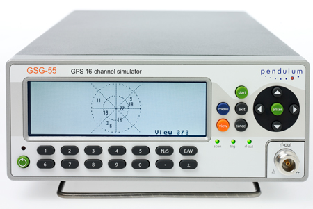
Spectracom, a global provider of time and frequency test and measurement solutions, will make available its new 16-channel GPS constellation simulator, the Pendulum GSG-55, in March. The GSG-55 is the latest in the Pendulum line of GPS receiver test instruments and part of its solution set for receiving, distributing, and validating GNSS systems.
With the enhanced signal generating capability of the GSG-55, it is possible to simulate Satellite-Based Augmentation Systems (SBAS), the company said. Navigation systems that use SBAS can improve the accuracy and reliability provided by the GPS satellite signals alone, enabling critical applications such as aircraft navigation, and surveying and mapping. SBAS simulation (support for Europe’s EGNOS and North America’s WAAS) is a new feature in the GSG-55. It is also able to generate white noise, making it possible to test receiver sensitivity under different signal-to-noise ratios.
“Many high-end GPS applications utilize 12-channel GPS receivers. Our new GSG-55 GPS constellation simulator can fully test those receivers with additional signals for more comprehensive testing in both development and production environments,” says Staffan Johansson, product manager at Spectracom.
The GSG-55 builds on the popular Pendulum GSG-54 eight-channel simulator including accurate testing of GPS timing receivers and portability through its compact and lightweight bench-top chassis. The GSG-55 also continues the Pendulum brand hallmark of ease-of-use. As such, the entire GSG family of GPS simulators has been improved based on customer feedbac, the company said.
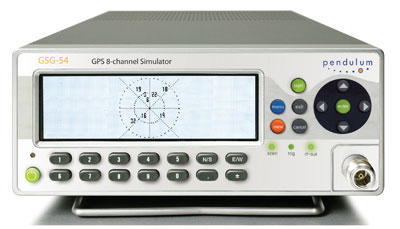
Spectracom’s new 8-channel GPS constellation simulator, the Pendulum GSG-54, provides a wide-range of capabilities for in-line production testing of devices integrating GPS receivers due to its ease-of-operation and fast test cycles. Its versatility also supports engineering organizations’ efforts for integrating GPS receivers into devices under development.
The Pendulum GSG-54 simulates the satellite signals detected by a GPS receiver. It comes in a bench-top chassis that is compact and portable. It offers built-in standards-based test scenarios that can be initiated or modified on the fly from the intuitive front panel interface, and offers a variety of connectivity options to control and reconfigure test parameters.
The GSG-54 GPS constellation simulator builds on the features available from Spectracom’s GSG-L1 single-channel GPS signal generator that offers simple but fast assembly verification for functions such as antenna connectivity, receiver operation, or satellite signal identification. The GSG-54 provides for many more test cases due to its ability to simulate eight different satellite signals to test position accuracy, sensitivity to loss of satellite signals, timing accuracy, and dynamic range. It can simulate movements and user trajectories, multi-path scenarios and various other atmospheric conditions.
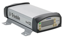
Trimble has introduced an innovative Global Navigation Satellite System (GNSS) reference receiver for infrastructure, precise scientific, and network applications. The Trimble NetR9 GNSS reference receiver is a Continuously Operating Reference Station (CORS) receiver that can support the demanding applications for the earth science community and for the surveying, construction, mapping, and agricultural industries, Trimble said, adding that the NetR9 was designed to provide the user with maximum features and functionality from a single receiver.
The Trimble NetR9 reference receiver offers 440 channels for robust GNSS constellation tracking. The receiver supports a wide range of satellite signals, including GPS and GLONASS signals. In addition, Trimble is committed to providing Galileo-compatible products in advance of Galileo system availability, the company said. In support of this plan, the Trimble receiver is capable of tracking the experimental Galileo GIOVE-A and GIOVE-B test satellites for signal evaluation and test purposes.
The Trimble NetR9 reference receiver can be used as a standalone receiver or as part of a network solution. Specific applications include high-accuracy positioning as part of a Trimble VRS network, as a mobile field base station or CORS for real-time kinematic (RTK) corrections, as a scientific reference station collecting information for specialized studies, as a field campaign receiver for post-processing applications, and as support for Differential Global Positioning System (DGPS) coastal beacons. In addition, the Trimble NetR9 reference receiver can be used for monitoring the integrity of VRS networks as well as the deformation of physical infrastructure such as bridges, dams, mines, oil platforms, and other natural and manmade structures.
The Trimble NetR9 reference receiver’s large internal memory (8 GB) allows post-processed results for base stations to be computed after survey completion, improving the accuracy of the survey. The highly compressed secure internal memory allows for more than 20 years of 15-second dual-frequency GPS data storage. In addition, the NetR9 also has USB logging capability for additional storage capacity, Trimble said.
The receiver supports the new CMRx communications protocol, which provides correction compression for optimized bandwidth and full utilization of all satellites in view. This gives the customer more robust positioning data and reliable positioning performance, Trimble said.
Optimized for field use with built-in rechargeable batteries, the NetR9 reference receiver consumes very little power and can be used for projects with remote connectivity and in extreme weather conditions. It has an IP67 rating, which means it is sealed against dust and can survive immersion in up to a meter of water for approximately 30 minutes. It also meets MIL-STD 810F standard for drops, vibration, and temperature extremes.
The Trimble NetR9 has its physical memory built into the circuit board, providing greater protection of data, particularly under extreme conditions. Multiple built-in serial ports supply communications and power to support field use, whether connecting to a radio for RTK surveys, direct communication with a satellite phone for remote operations, or for ancillary input devices such as inclinometers and meteorological sensors, and it offers Bluetooth communication with a cell phone for real-time data streaming. In addition, both power and Ethernet can be supplied over a single cable using Power over Ethernet (PoE) technology.
The I/ITSEC (Interservice / Industry Training, Simulation & Education Conference) held in Orlando is not a GIS conference but GIS is playing an increasing role in training and simulation. With over 5,000 attendees and over 500 exhibitors this is the conference of the year for those in the training and simulation business. This is a large conference that can’t be taken in by one person so the following are some snap shots taken from a GIS perspective.
I/ITSEC demonstrated that the bar is being raised in all aspects of this multi-million dollar technology industry. The early days of training simulation was exemplified by LINK trainers which were early aircraft trainers that trained thousands of pilots during WWII. The trainers were estimated to have saved thousands of lives and millions of dollars in aircraft. Now the current generations of trainers have moved well beyond the simple stick, pedals and crude instruments that were the hallmark of the early LINK trainers but the objective is still the same. Substitute training simulators for real hardware and save lives and millions of dollars in the process.
The aircraft trainers demonstrated at I/ITSEC are as specialized and sophisticated as the aircraft they simulate. The simulators are no longer gee whiz video games. The current trainers approach realism that in some cases is indistinguishable from reality. Some simulators that were on display even simulate G forces through tactile sensations created by the seats. I tried one out and the affect was compelling but still not the real thing. If you are a video-gaming enthusiast this conference is a “Candy Store.” The hardware is absolutely real and most of the simulators use very high powered computer environments.
GIS plays an increasing role as engineers seek to create training simulators that are not only used for generic training but actual mission rehearsal. The simulators need to accurately display features, terrain, navigation and communication while also displaying different weather conditions. One can see the blurring of the line between being in an actual aircraft, being in a trainer or remotely piloting a UAV.
In the training simulation business they use the term “database” slightly differently that we do in GIS. Their database includes all the GIS type vector data of the flight environment but also includes, ground elevation models, draped imagery, 3D structure models, the objects and skins that populate the models and all the underlying physics that make the models behave realistically.
Fast accurate 3D model creation is major requirement of our military for training but increasingly more important for mission rehearsal. 3D modeling is becoming more sophisticated and robust with four vendors PLW, IAVO, Cogent3D and Clear Edge 3D approaching the “Holy Grail” of modeling, an automated process to create 3D models from ortho, oblique and ground level images with minimal human intervention.
I saw improvements in display technology, nothing really new but significant refinements. Large HD flat screens have replaced smaller LCD monitors. More air and ground simulators now use spherical and wrap around projection screens. There are also significant improvements to the imagery as they refine the optics to take full advantage of the screens and reduce distortion. JVC and Sony both displayed extremely high resolution and very high refresh rate digital projectors that showed no signs of blurring on even fast moving objects. They made me want to scrap my Blu-ray / 1080p home theater until I saw the price tag. Yes, if you have to ask you probably can’t afford it. With the new displays they can accurately show fast moving aircraft from an initial pinpoint on the horizon to a Mach 3 fly by.
The blurring of the lines between the gaming industry, simulation and GIS continued on the ground with numerous ground combat simulators. Avatars are becoming so realistic in motion and detail that they rival video of actual players. Avatars not only move with fluid motion but their movements have built in physics so they behave appropriately when running and jumping with back packs and other loading conditions. Many of the ground simulators work with real geo-referenced data and actual building imagery. Even more impressive are recognizable emotions on the Avatar faces.
One group of tools that has been used to create realistic avatars is motion tracking devices. Even here the bar has been raised. Last year one company demonstrated the ability to make an Avatar move in perfect synchronization to movements of a live actor wearing a suite with sensors that were tracked by computer. This year two companies were displaying the same capability and both were upstaged by a new company, Organic Motion, that did the same avatar mimicking but without wearable sensors. They instead used multiple video cameras and computers to analyze the motion of objects in 3D space and then immediately mimic the motion with avatars.
Organic motion.
A Canon distributor was demonstrating a Canon mixed media set of 3D goggles. This is a significant refinement of an experimental display I saw several years ago at a GIS conference. Those goggles displayed GIS or CAD drawing data overlaid on the real world view. The hard part was maintaining registration of the abstract data with the real world despite head movements. The early version did that by placing a GPS receiver on the head piece to constantly serve as a geo-reference. It was crude but I could imagine that some day construction workers would wear these kinds of goggles to “see” buried cables and piping prior to digging. Obviously GIS data accuracy, integrity and verification would be paramount.
The new Canon mixed media goggles were a significant leap in quality. The resolution and optics were superb. When I put them on I could still see the real world but overlaid in my field of vision were 3D objects that looked like they were actually their. I’m not sure where this will lead but the viewing of GIS data on the real world is certainly now possible.
Canon Mixed Media.
Professor Amela Sadagic and Marine Corps Captain Aaron Burciaga of the Naval Postgraduate School were demonstrating a Virtual Sand Table that combines projected imagery and computer notations onto a table with 3D physical models.
Virtual Sand Table.Sand Table.
The trainers are not only visually impressive but are providing very realistic tactile feedback. Some are as simple as a video firing range that not only provided a realistic video image but provided a realistic kick back by using a CO2 cartridge within the fake magazine. I tried the Glock 19 and it felt exactly like firing my own gun on a range but without the ammo cost and a more realistic target environment. Even Segways have entered the training and simulation business with Marathon Robotics demonstrating human sized mannequins that can move about a training environment through wireless control. The robots even have on-board intelligence to react to unexpected situations.
Marathon Robotics.
A very gratifying volunteer event in the Exhibit hall was Lockheed Martin’s purchase of cases of personal items needed by our troops in-theater. They set up a “Fill the Box” production line staffed by conference attendees who moved down the line filling a box that was finished with a personal note to a service member. The boxes were sealed and shipped by Lockheed Martin whose motto is “We never forget who we’re working for” and in my personal experience they really mean it. This was a good close to a very interesting conference.
GPS DATA maintains a 3D model that keeps a car correctly positioned while passengers hunt down werewolves.
Look out the window — is a werewolf hiding behind that tree?
Looking out the window while on a long car trip can be an adventure with a new GPS-based game being developed by The Interactive Institute in Stockholm, Sweden. The Backseat Playground uses GPS to turn passing sights like forests, buildings, and rivers into locations for in-game characters and events, reports New Scientist magazine. Backseat Playground consists of a GPS receiver, a handheld computer, and headphones — all connected to a laptop in the trunk of the car. A database of geographical information is used to match events in the game to suitable locations. Game characters and events are all generated dynamically during the car trip.
The game begins with a radio newsflash, relayed by the handheld computer, which places a passenger at the start of a murder mystery or a werewolf thriller. As the car travels along its route, the player receives further phone calls and messages from in-game characters.
Players interact mostly by listening; minimal graphics are involved, according to the designers. “It’s like a novel,” said John Bichard, who created Backseat Playground with colleagues Liselott Brunnberg and Oskar Juhlin. “We are trying to suggest spaces and places and events and have the user fill in the gaps to build a narrative.”
For now, a prototype now being evaluated only works over an area of 35 square kilometers in Stockholm. Initial feedback has been positive, and the team hopes to add voice recognition to the set-up. “Being able to talk directly to the characters would be great,” Bichard said.
We’ve always wondered what those werewolves had to say.