A roundup of recent products in the GNSS and inertial positioning industry from the October 2024 issue of GPS World magazine.
SURVEYING & MAPPING
 Updated CAD Software
With enhanced features and workflow improvements
Topcon Positioning Systems has released a new version of its computer-aided design (CAD) software suite, formerly known as MAGNET. With enhanced features and workflow improvements to the Office, Field and Tools modules, version 9 is also renamed under the Topcon software suite as the business retires the MAGNET brand.
The software is designed for professionals such as surveyors, engineers, modelers, estimators and project managers, aiming to improve productivity through integrated software capabilities and workflows. It can be used as standalone, office-based CAD software or as a cloud-connected solution that integrates field and office operations with Topcon or Sokkia survey instruments. The platform offers user-friendly and versatile configurations suitable for various applications.
Topcon Office version 9 introduces new options for working with digital terrain models (DTMs), spot elevations and offset capabilities, enhancing versatility when handling 2D or 3D data sets. Improvements in Topcon Field include better productivity and stake reporting capabilities, advanced resection functionality for unknown control points and a new offset routine for creating points that are not observable with a total station. Both Field and Office modules now support direct import and export with 12D XML file formats.
Subscribers to the AllDayRTK high accuracy positioning network can now directly import and export RINEX data into Topcon Tools with a current Plus or RINEX subscription. Version 9 of Topcon Tools also features improved coordinate system functions, new traverse calculations, viewing options and enhanced functionality for working with data in tabular view for reporting.
Topcon Positioning Systems, topconpositioning.com
 4D Scanner
For AEC professionals
The PIX4Dcatch smartphone scanning application is now compatible with the Bad Elf FlexGNSS receiver. This integration is designed for professionals in the architecture, engineering and construction (AEC) industries.
PIX4Dcatch is a comprehensive 3D scanning and AR visualization tool that combines photogrammetry, lidar technology and real-time kinematic (RTK) positioning for precise results.
The Bad Elf Flex GNSS receiver offers scalable accuracy and flexibility. In its standard configuration, it provides 30-60 cm real-time accuracy for GIS applications. Its daily token model allows users to unlock full RTK workflow for 24-hour periods, achieving 1 cm horizontal accuracy when needed. For users requiring consistent high accuracy, an upgrade to the Bad Elf Flex Extreme is available for permanent RTK capabilities.
By combining PIX4Dcatch with the Bad Elf Flex GNSS receiver, surveying, construction and building professionals can now create highly accurate 3D models using mobile smartphone scanning technology. The resulting scans can be exported to CAD/GIS platforms for inspection, sharing and collaboration among project stakeholders.
Bad Elf, bad-elf.com
UAV
With an integrated bathymetric system
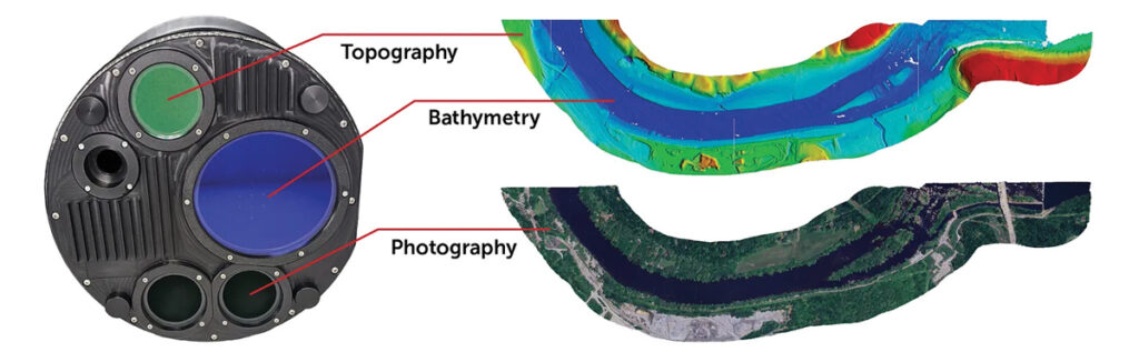
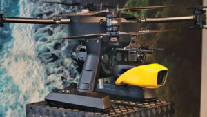 The YellowScan Navigator bathymetric system has been integrated into Xer Technologies’ UAVs. This collaboration aims to enhance UAVs’ capabilities for conducting long-range bathymetric surveys and underwater inspections, which are essential in various fields such as environmental monitoring, coastal management and infrastructure development.
The integrated system allows users to collect high-resolution and accurate bathymetric data, even in challenging aquatic environments. YellowScan’s green laser lidar technology is a key component of this system, providing precise underwater mapping capabilities. Xer Technologies’ UAVs are designed for extended flight durations and can operate for more than two hours, facilitating coverage of larger survey areas in a single mission. This feature is particularly beneficial for projects that require extensive data collection over vast aquatic regions.
The YellowScan Navigator can achieve a precision of 3 cm and can operate at a maximum altitude of 100 m above ground level. The laser has a range of up to 120 m and features a scanner field-of-view of 44°. It weighs 3.7 kg.
Xer Technologies, xer-tech.com
Sonar Series
For underwater applications
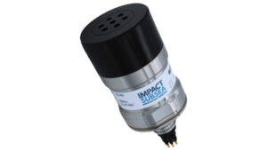 The ISS360 Sonar Series is a range of imaging sonars designed for underwater applications. This series provides a full 360° field of vision and can detect objects at distances of up to 90 m to 100 m. The ISS360 utilizes compressed high-intensity radar pulse (CHIRP) acoustics to provide image clarity and quality.
The ISS360 operates within a frequency range of 600 kHz to 900 kHz, offering an angular resolution of 2.2° at 700 kHz and a range resolution of 2.5 mm at lower ranges. The sonar is housed in durable titanium material, providing a depth rating of 4,000 m as standard, with an option available for a 6,000 m rating. Additionally, it has a low power consumption of 3.6 watts, making it efficient for prolonged use.
The CHIRP acoustics enable adjustable frequency bandwidth for optimized performance in various conditions.
Its inductive coupling design eliminates the need for slip rings, significantly improving the longevity of the device. For those needing additional data, an optional attitude reference system provides pitch and roll measurements. The sonar comes equipped with seaView software for easy operation, as well as a software development kit (SDK) for custom integrations.
The series includes two main models: the standard ISS360, which is suitable for a wide range of applications, and the ISS360HD, which offers higher angular resolution and range capability for more demanding operations.
Impact Subsea, impactsubsea.com
Machine Control
Farming Management System
With an API link
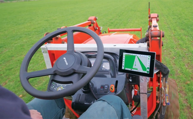
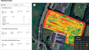 CropX and CNH Industrial have launched a new digital connection to enhance precision farming and sustainability. This integration establishes an application programming interface (API) link between CropX’s agronomic farm management system and CNH’s Case IH and New Holland Agriculture equipment.
The new connection streamlines data transfer from CNH machinery to CropX, enabling automated data visualization, record-keeping, planning and variable-rate applications. This comprehensive data transfer covers a wide range of farming activities, including planting, application and harvesting, with specific data points varying based on the equipment type.
Within the CropX platform, this information is presented in user-friendly tables and maps that can be overlaid with other data layers. This feature allows farmers and agronomic advisers to easily extract valuable insights for improved decision-making. Furthermore, the integration facilitates the creation of variable rate application maps for fertilization and seeding, utilizing advanced agronomic tools within CropX’s system.
CropX, cropx.com
Agricultural UAV
For crop and data management
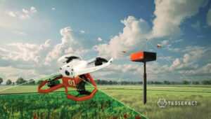 The Tesseract Ag Drone is an agricultural drone designed to improve crop and data management for farmers.
This U.S.-made drone utilizes computer vision and optical technologies to offer farmers detailed, real-time information about their fields. With its comprehensive suite of functionalities, the Tesseract Ag Drone enables farmers to quickly identify pests, monitor weed growth, assess crop and soil health, track weather impacts and observe crop development.
When paired with the Tesseract Synthesis Software, the drone’s software can transform raw data into actionable insights, allowing farmers to make informed decisions using tools powered by artificial intelligence. The centralized data management system is designed to streamline collaboration among farm teams, fostering teamwork and improving overall productivity.
Tesseract Ventures, tesseractventures.io
Transportation
Fleet Tracking Platform
Designed to improve operational efficiency
 CerebrumX Labs and Onward Fleet Solutions have partnered to improve fleet management through advanced data analytics and artificial intelligence (AI). This collaboration integrates CerebrumX’s augmented deep learning platform (ADLP) with Onward’s comprehensive fleet management system, offering fleet operators insights into their vehicles and operations.
The partnership leverages real-time data and robust reporting to enhance operational efficiency, reduce costs and improve driver safety. CerebrumX’s ADLP offers live fleet tracking, ensuring constant visibility of vehicle locations.
Additionally, it analyzes trip histories to uncover patterns in driver behavior and vehicle usage for fleet managers to make data-driven decisions. Users can also generate customized reports to help optimize various aspects of fleet management, including driver safety protocols, vehicle maintenance and fuel efficiency.
The system integrates AI to process vast amounts of data from electric and connected vehicles to provide crucial insights into asset performance, energy consumption and maintenance requirements. This capability is particularly valuable for optimizing electric vehicle charging schedules, improving battery life and supporting the broader transition to greener transportation solutions.
Onward Fleet Solutions, onwardfleet.com
UAV
Aerial Imagery Solution
With Updated Features
 PhotoCapture version 2 is a photogrammetry and aerial imagery solution designed for aerial imaging professionals, surveyors, engineers and other applications that require highly accurate UAV data.
The new Photocapture Standalone Basic features a new Windows-based foundation with simple installation, a faster user interface, overlap adjustment, more available projections and faster overall photogrammetry processing speed.
PhotoCapture Standalone Advanced adds the Survey Canvas, which allows manipulation of processed point cloud data such as stockpile volume calculations, the drawing of linework, surfaces and more, all within the PhotoCapture program. New to the PhotoCapture Survey Canvas in version 2 is the View Site feature for viewing changes on sites over time, as well as the ability to remove moving objects.
PhotoCapture Standalone Advanced also now offers lidar colorization and processing, allowing the integration of lidar and photogrammetry data. Drawing on the strengths of each technology, this new feature creates more accurate and more visually appealing point cloud outputs.
Carlson’s PhotoCapture Web version offers a completely online solution utilizing cloud computing for processing power and featuring all the functionality of Carlson PhotoCapture Standalone Advanced.
Carlson Software, carlsonsw.com
UAV Lidar System
With long-range capabilities and heavy payload capacity
 GeoCue and Xer Technologies AG have integrated GeoCue’s TrueView 720 lidar and imagery sensor with the Xer X8 UAV platform.
The integration represents an advancement in aerial operations, particularly for mapping and inspecting large, challenging terrains. By combining the long-range capabilities and heavy payload capacity of the Xer X8 with the high-quality point cloud and imagery data collection of the TrueView 720, this solution allows operators to manage and monitor vast areas with precision and efficiency.
Xer Technologies, xer-tech.com
Map Processing Software
Designed for construction, mining and urban planning
 The WingtraCLOUD software platform now features map processing capabilities to streamline the integration of aerial insights into industries such as construction, mining and urban planning.
The latest updates seek to help engineering firms and users transition more smoothly from UAV data to actionable insights. By consolidating all stages of aerial data management — from mission planning to insight sharing — into a single platform, WingtraCLOUD eliminates the need for multiple complex tools to simplify workflows.
This software is designed to reduce errors, prevent rework and accelerate project timelines, leading to increased productivity across key industries.
With WingtraCLOUD, large-scale mapping projects can be completed quickly. This rapid processing capability is ideal for industries such as construction, where it helps avoid costly delays and resource waste, and in mining, where it enhances safety through quick highwall inspections. In disaster scenarios, WingtraCLOUD’s fast mapping capabilities can aid in efficiently directing resources.
Wingtra, wingtra.com
Compact UAV
Equipped with a 1/2-inch image sensor
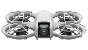 The DJI Neo is a lightweight compact UAV designed to make aerial photography and videography more accessible.
DJI Neo can be fully controlled without a remote, allowing for palm-based launches and landings. It features AI subject tracking and QuickShots, offering 4K ultra-stabilized video with a flight time of up to 18 minutes.
The Neo is equipped with a 1/2-inch image sensor capable of capturing 12MP stills and 4K UHD video at 30 fps. DJI’s powerful stabilization algorithms, including RockSteady and HorizonBalancing, ensure smooth and stable footage even in challenging conditions.
The Neo includes 22 GB of internal storage, capable of saving up to 40 minutes of 4 K / 30 fps video. It supports wireless file transfer to smartphones and easy audio recording through the DJI Fly app.
DJI, dji.com
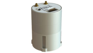
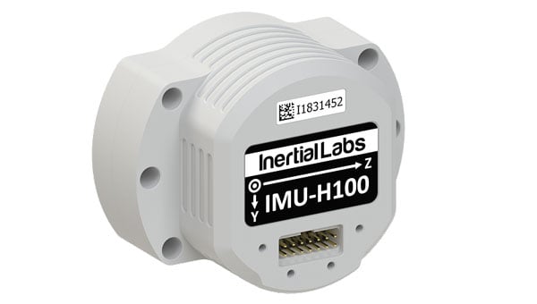
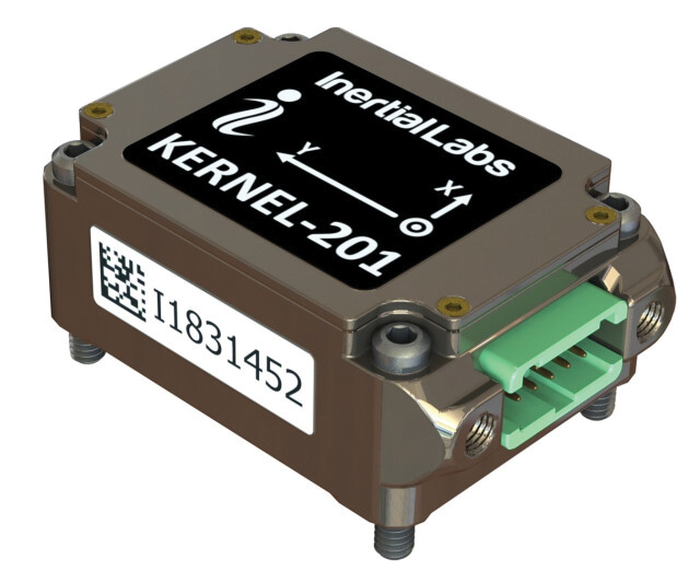
IMU
For precise navigation and stabilization
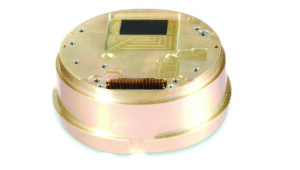
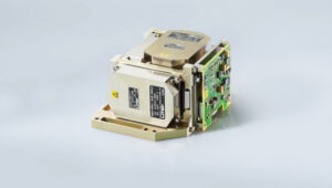 LITEF fiber optic gyroscope (FOG) inertial measurement units (IMUs) are designed for precise navigation and stabilization in various applications such as UAVs. These units feature a comprehensive sensor suite, incorporating three gyroscope axes for rotational measurement and three accelerometer axes for linear acceleration detection. This configuration ensures accurate tracking of an object’s movement in three-dimensional space.
The IMUs include processing electronics, power supply and input/output interfaces to streamline installation and operation, making them ideal for complex navigation tasks.
For applications demanding even higher precision, LITEF offers the option to integrate GPS and GNSS receivers with their IMUs. This fusion of inertial and satellite-based navigation technologies is designed to enhance overall system performance, providing more robust and accurate positioning data.
LITEF, litef.de
OEM
GNSS Receiver
With Xona PULSAR functionality
 Locus Lock has partnered with Xona Space Systems to develop a GNSS receiver that uses Xona’s multi-frequency PULSAR service. Locus Lock aims to provide a robust software-defined GNSS receiver suited for both commercial and military applications.
Xona’s PULSAR service will be delivered via a constellation of low-Earth orbit (LEO) satellites, which orbit the Earth approximately 20 times closer than GNSS satellites, according to the company. This proximity allows PULSAR to offer higher signal power and a modernized signal design to offer improved multipath mitigation, higher accuracy and increased protection against radio frequency interference and spoofing compared to current GNSS systems.
The technology is suitable for a wide range of applications, including vehicles navigating dense urban areas, agriculture and construction, UAVs, high-speed aircraft and defense applications. Locus Lock’s GNSS software stack can be deployed on existing customer computational infrastructure, ranging from small embedded devices to larger centralized computers. This flexibility allows for adaptation and configuration of the software to suit specific deployed environments.
The system features inertially-aided carrier-phase differential GNSS (CDGNSS) for maintaining precision in challenging ecosystems, advanced interference mitigation and detection technology to ensure authentic GNSS signals are received and the dual-antenna, triple-frequency RadioLion RF front-end for capturing raw GNSS signals. These features offer signal situational awareness, anti-spoofing and interference mitigation.
Locus Lock, locuslock.com
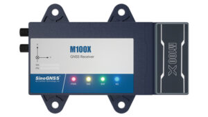
Dual-Band Receiver Board
With integrated IMU
 The simpleRTK2B Fusion GNSS RTK dual-band receiver board is a positioning solution that leverages the u-blox ZED-F9R module to provide highly accurate location data.
This board delivers centimeter-level positioning accuracy, making it suitable for applications requiring precise location information. One of its key features is the integrated inertial measurement unit (IMU), which allows the board to provide full attitude data using a single antenna. This capability is particularly beneficial for compact and resource-constrained systems.
The board’s design makes it suitable for small, unmanned ground vehicles (UGVs) and slow-moving ground robotics platforms. These applications can greatly benefit from the board’s high-precision positioning and attitude information, enabling more accurate navigation and control.
The simpleRTK2B Fusion board can be seamlessly integrated with various popular development platforms. It can serve as an external GNSS RTK receiver for autopilot systems and is compatible with both Pixhawk and Ardupilot-based autopilots, enhancing their positioning capabilities with its centimeter-accurate data.
ArduSimple, ardusimple.com
Defense
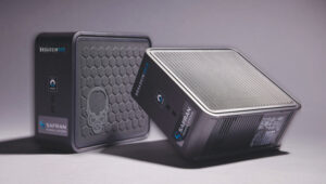
Rugged Ground Control Station
For commercial and defense applications
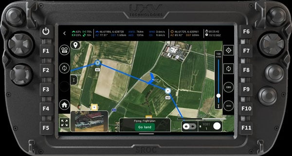
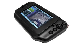 The Controller Pro is a ground control station (GCS) technology for UAVs and robotics. It seeks to address the growing demand for compact, powerful and versatile control solutions in both commercial and defense sectors.
The 8-inch Controller Pro boasts a rugged design with an IP65 rating, ensuring durability and protection against dust and water ingress. Equipped with Intel Core i3, i5 and i7 processors, the Controller Pro offers robust performance for mission-critical operations, enabling smooth handling of complex control tasks and real-time data processing. Additionally, the integration of Windows 11 enhances the system’s flexibility and compatibility with various software solutions, allowing for multi-application performance.
The Controller Pro can be used for surveying, inspection and delivery services. Its rugged design and U.S. National Defense Authorization Act (NDAA) compliance make it ideal for military and law enforcement applications, such as reconnaissance and tactical operations.
Additionally, its radio-agnostic feature allows it to work with various communication systems, enhancing its versatility across different platforms and missions.
Mobilicom, mobilicom.com
Aerial Reconnaissance and Elimination System
With integrated AI technology
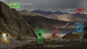 The Aerial Reconnaissance and Elimination System (ARIES) is designed to enhance situational awareness and counter emerging threats.
ARIES utilizes AI to detect, classify and respond to threats in real time. The system’s AI continuously adapts to new threats across multiple domains without requiring manual updates to improve situational awareness and accelerate decision-making for military personnel.
The system can detect and track UAVs beyond visual line of sight (BVLOS). This capability extends the range and effectiveness of counter-unmanned aerial system (C-UAS) operations, providing early warning and enabling rapid response to potential threats.
ARIES seamlessly integrates with existing defense infrastructure, which eliminates the need for frequent manual system updates and seeks to improve overall mission success rates.
The system has been successfully demonstrated to key Department of Defense (DOD) stakeholders, showcasing its potential to enhance counter-UAS operations. During the demonstration, ARIES offered critical, real-time intelligence for swift decision-making in response to UAV incursions.
Skylark Labs, skylarklabs.ai
Quadcopter UAS
Department of Defense Blue UAS-certified
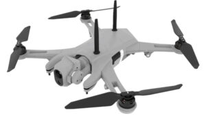 The Teal 2 is a multirotor unmanned aerial system (UAS) designed for military, government and commercial applications. Designed, built and serviced entirely in the United States, the Teal 2 is Department of Defense (DOD) Blue UAS-certified, ensuring it meets stringent standards for government use.
Its compact and rugged design allows for easy transport and rapid deployment, as it can be folded and carried in a rucksack. Additionally, the modular construction of the Teal 2 facilitates easy repair and reconfiguration in the field, enabling operators to adapt the system to their specific mission needs.
The UAS weighs 1.25 kg, can reach maximum speeds of 10 m/s and has a flight time exceeding 30 minutes. It is equipped with the FLIR Hadron 640R electro-optical/infrared (EO/IR) sensor system, which includes a dual-axis gimbal for stable imaging. This thermal imaging system excels in nighttime operations, allowing operators to identify and track targets even in complete darkness.
The Teal 2 supports advanced operational features such as multi-vehicle command and control, which allows for 360° target views or multi-target surveillance. It employs AES-256 encryption for secure data transmission and communication. Powered by the Snapdragon 845 processor, the Teal 2 is also compatible with Athena AI, designed to enhance its capabilities in target recognition and battle tracking.
Red Cat Holdings, redcat.red
Radar System
Designed for C-UAS and BVLOS flights
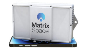 This radar system is designed to enhance situational awareness for counter unmanned aircraft system (C-UAS) operations and beyond visual line of sight (BVLOS) flights. The system, which has received Federal Communications Commission (FCC) authorization, is now being distributed to commercial and public sectors in the United States and to certain international markets.
The system aims to deliver precise detection of both airborne and ground-based objects under various conditions. Its compact design allows for integration into existing infrastructures without the need for extensive setup or specialized training.
The MatrixSpace Radar is part of an open architecture platform, facilitating integration with various industry-standard systems for unmanned traffic management (UTM), command and control, counter-UAS measures, and traffic and video surveillance systems. This approach aims to offer a unified view for operators to improve the coordination and management of airspace activities.
MatrixSpace, matrixspace.com


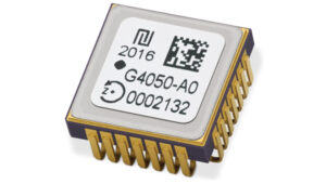 High-Dynamics MEMS Gyro
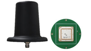 Anti-Jamming
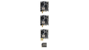 Triple-Band RTK Receivers
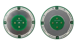 OEM GNSS Antenna
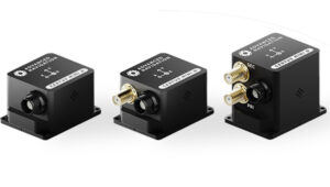 OEMs
OEMs Direct Georeferencing Solution
 Fixed-Wing UAV
 GNSS Receiver
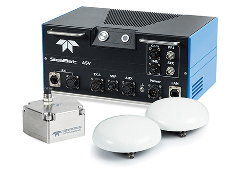
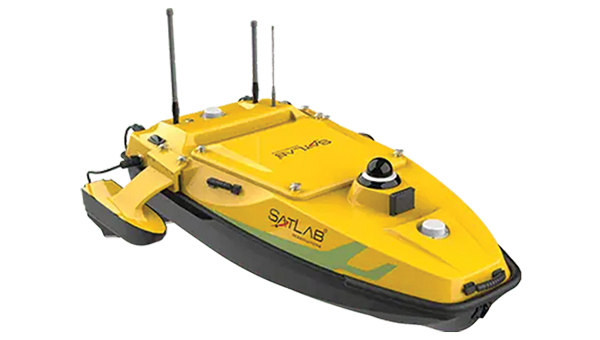
 USV
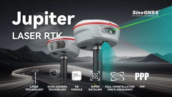
USV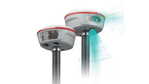 Laser RTK
 UAV Lidar Scanner
 Receiver
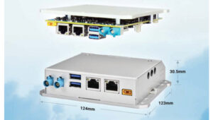
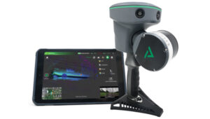 Software Solution
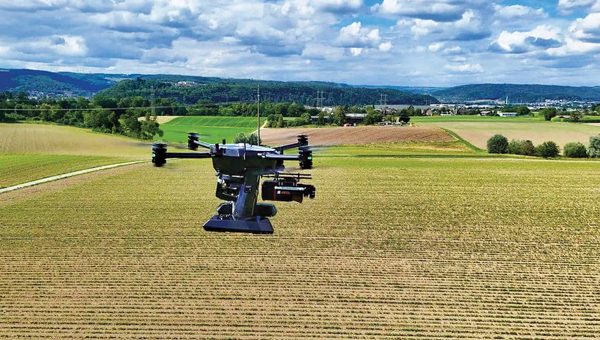

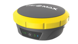
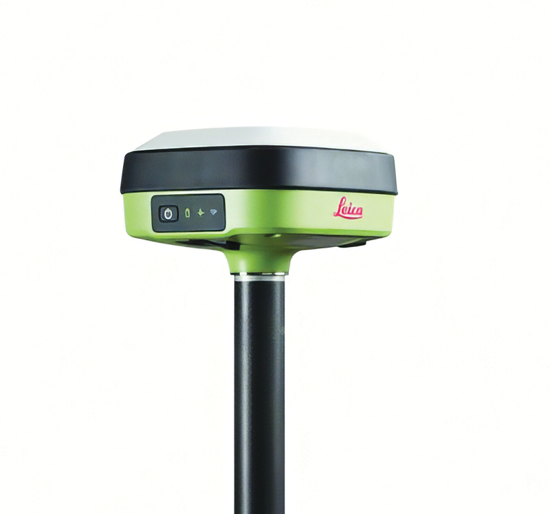
 Upgraded RTK Rover
 3Dsurvey 3.0 is an all-in-one photogrammetric software solution designed to unify lidar sensors, cameras on UAVs and various ground control points. Users can transition between orthophotos, point clouds and textured meshes.
 RTK Evaluation Kit
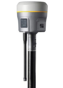 GNSS Receiver
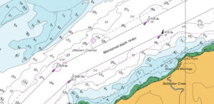 CARIS AutoChart, a nautical chart production solution, is tailored to the needs of nautical chart producers. It can automatically generate charts in PDF/TIF from ENC data. Users can seamlessly import data from ENC files to create comprehensive nautical charts in PDF and/or TIF format. CARIS AutoChart can generate chart templates from existing chart portfolios maintained with CARIS paper chart composer or CARIS HPD paper chart editor.
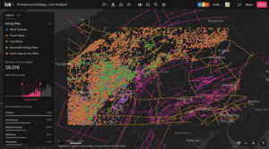 Felt 3.0 includes new features and native database integrations to improve the capabilities of geographic information systems (GIS). It provides modern GIS tools for teams to visualize, analyze and present important insights and map data relevant to their operations.
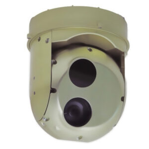 Gimbaled Camera
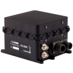 The FN 200C combines multiple functions into a single integrated platform. It features a three-in-one strapdown system compromising motion reference unit (MRU), attitude and heading reference system (AHRS) and inertial navigation system (INS) capabilities for precise positioning, velocity and orientation data in both static and dynamic movements.
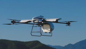 The RDSX Pelican extended-range hybrid vertical take-off and landing (VTOL) delivery UAV is now offered with an easily modifiable flight controller, designed for users to more readily integrate customized flight systems and companion software.
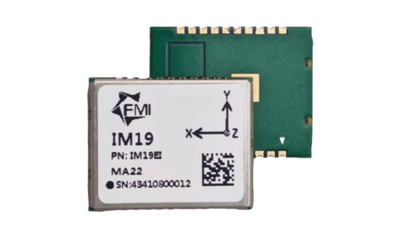
 GNSS Positioning Modules
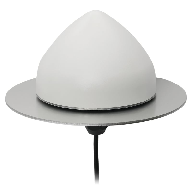
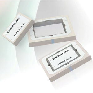 Inception is a new GNSS L1/L5 ultra-low-profile “patch-in-a-patch” antenna. The HP5354.A offers dual-band stacked patch performance in a single 35 mm x 35 mm x 4 mm form factor. This design integrates the second antenna within the first, eliminating the need for stacking parts and reducing the antenna height by 50%.
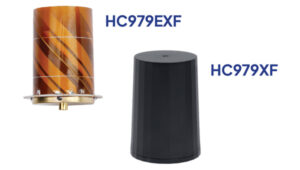
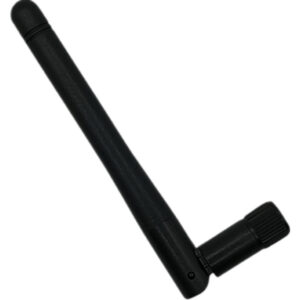 Waterproof GNSS Antenna
 AQNav is designed for navigation across air, land and sea when GPS signals are jammed or unavailable.
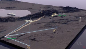 TRNAV is a terrestrial navigation solution designed to operate with or without GNSS signals.
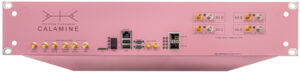 Calamine is a four-channel wide tuning range software-defined radio (SDR) that can be integrated into mission-critical systems for the defense, GNSS, communications and test and measurement markets.
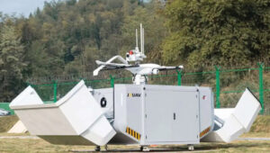
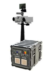 C-UAS Solution