Tag: product showcase

  • Garmin adds L5 to new adventure trackers

    Garmin adds L5 to new adventure trackers

    Photo: Garmin
    Photo: Garmin

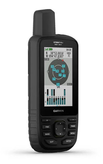
    Garmin has debuted the GPSMAP 65, 65s and 66sr, three new portable devices with improved technology, precision and connectivity. GPSMAP is the company’s line of premium outdoor navigation units.

    The GPSMAP 65, 65s and 66sr offer multiband technology for positioning and tracking anywhere. They are the first Garmin portable devices to receive and use multiple satellite navigation frequencies.

    The multi-band technology and expanded GNSS support with addition of the L5 frequency (GPS, GLONASS, Galileo, QZSS and IRNSS) allows for reduced estimated position error, giving users improved accuracy and awareness of their surroundings.

    The new models include TopoActive maps of Europe, smartphone notifications, color screens, battery improvement, compatibility with the Garmin Explore app and more. All three are rugged, dust, shock and water resistant (IPX71 rated).

    “We are excited to grow our popular lineup of GPSMAP handhelds and introduce multiple GPS frequencies into the series,” said Dan Bartel, Garmin vice president of global consumer sales. “We’ve expanded our satellite support so you can explore with confidence, no matter where you go or what the conditions are.”

    GPSMAP 66sr

    The premium version, GPSMAP 66sr, has a 3-inch color screen readable in all lighting conditions and is compatible with night-vision goggles. In addition, it has been designed to military standards for thermal performance and resistance to shock and water (MIL-STD-810G), and includes a built-in S.O.S. LED flashlight for assistance. To give the user even more confidence, incorporates ABC sensors (3-axis electronic compass), accelerometer and barometric altimeter), allowing users to obtain the most accurate data available at all times.

    GPSMAP 66sr also provides global forecasts and weather through the Active Weather feature, updated through wireless connectivity via Bluetooth and ANT +. Via the Wi-Fi connection, users can download satellite maps.

  • Inertial Labs releases INS-DU GPS-aided unit for high-accuracy positioning

    Inertial Labs releases INS-DU GPS-aided unit for high-accuracy positioning

    The new INS-DU delivers high-accuracy RTK positioning for air, land and marine applications

    Photo: Inertial Labs
    Photo: Inertial Labs

    Inertial Labs has released a new GPS-aided inertial navigation system (INS). The INS-DU is a high-performance strapdown system that determines position, velocity and absolute orientation to any platform it is mounted to.

    The INS-DU has a dual-antenna u-blox GNSS receiver that provides 1-cm real-time kinematic (RTK) position from RTCM 3 RTK corrections and supports a wide range of GNSS constellations.

    Designed for UAVs, land vehicles and marine vessels, the INS-DU is an effective, low-cost solution that uses a range of aiding data for different applications. With highly accurate navigation in GNSS-denied environments, the INS-DU delivers a cost-effective GNSS-denied solution, according to Inertial Labs.

    One of the key elements to the success of the INS-DU is its use of the miniAHRS, which utilizes 3-axes each of precision magnetometers, accelerometers and gyroscopes to provide orientation of the device under measure. It contains cutting-edge algorithms for the motion of robots, unmanned and autonomous vehicles, and antennas.

    MiniAHRS mini fluxgate magnetometers have an advantage over commonly used magneto-inductive or magneto-resistive alternatives and have been a trusted North reference for more than 70 years.

    The INS-DU provides a full navigation solution for both GNSS and GNSS-denied environments. With custom interfaces and a power consumption of two and a half of a Watts, the INS-DU is a versatile solution fit for a wide variety of users with power consumption restrictions.

    In addition, the INS-DU contains our on-board sensor-fusion filter, state-of-the-art navigation, and guidance algorithms and calibration software.

  • Global Mapper v22 has 3D eye dome lighting and lidar painting

    Global Mapper v22 has 3D eye dome lighting and lidar painting

    Terrain Painting in Global Mapper v22. (Image: Blue Marble)
    Terrain Painting in Global Mapper v22. (Image: Blue Marble)

    Blue Marble Geographics has released version 22 of Global Mapper along with an upgrade to the accompanying Lidar Module.

    Global Mapper GIS software provides both novice and experienced geospatial professionals with a comprehensive array of spatial data processing tools, with access to a variety of data formats.

    Among other features, Version 22 includes

    • Eye Dome Lighting settings in the 3D viewer to help improve the visual display of vector and lidar data
    • a new tool for simplifying meshes or TINs
    • a new Spatial Operations tool for analyzing the relationship between overlapping vector features
    • a new option to measure the overlap between two or more lidar, raster/image and terrain layers
    • a new consolidated Digitizer Menu providing convenient access to all drawing and digitizing tools

    The Lidar Module, an optional add-on to Global Mapper, provides advanced point cloud processing tools, including Pixels to Points for photogrammetric point cloud creation using overlapping drone-captured images, automatic and manual point cloud classification, feature extraction, hydro-flattening, and more.

    Terrain Paint tool. The upgraded Lidar Module includes a new Terrain Paint tool for manipulating elevation values in a freeform way, a new algorithm to improve building classification results, improved building extraction with better 3D shape simplification for generating building footprints, a new option to create a process summary report when using the Pixels to Points process, dramatically faster rendering of lidar path profiles with a large number of points, and more.

    “The version 22 release illustrates Global Mapper’s rapidly expanding geospatial footprint,” stated Blue Marble’s President, Patrick Cunningham. “In this one release cycle, we have introduced countless new tools for GIS analysis.Global Mapper is truly an accessible yet powerful GIS platform. As always, we are pleased to be able to bring all of these capabilities together in one GIS platform while keeping the price affordable.”

    Blue Marble Application Specialists will hold a webinar Sept. 30 to showcase Global Mapper v22. This presentation is scheduled to begin at 2:00 pm (U.S. Eastern Time), and it will allow attendees to see the latest tools and ask questions about the new functionality. Registration is required.

  • Skyward-Parrot partnership brings integration and training for ANAFI USA

    Skyward-Parrot partnership brings integration and training for ANAFI USA

    The ANAFI USA drone. (Photo: Skyward)
    The ANAFI USA drone. (Photo: Skyward)

    Skyward, a Verizon company, and Parrot, a European drone group, are partnering to deliver Parrot ANAFI drones along with Skyward drone program management, flight-log sync and training to U.S. enterprises.

    In particular, the new speaks to a widespread need among U.S. companies and public agencies for a secure, high-end drone manufactured domestically. Sold by Skyward, the ANAFI USA and training package gives enterprises a one-stop shop for building and scaling a drone program with aircraft, policies and procedures, training, and automatic flight log sync to the software platform to manage it all.

    “ANAFI USA was designed to meet the needs of the most demanding professional users while offering enterprise data security and privacy,” said Henri Seydoux, founder and CEO of Parrot. “Now, combined with Skyward’s enterprise drone solutions covering training and integrated software platforms, professional users have access to one of the most comprehensive suites of hardware, software and services.”

    In addition to its security benefits, Parrot’s ANAFI USA features 32x zoom 4K HDR video and thermal imaging capabilities. It is portable, weather-resistant and ready to launch in seconds.

    “Now enterprises can maximize their investment in the ANAFI USA by pairing it with Skyward’s in-person and online operator training and robust management platform,” said Mariah Scott, president of Skyward, A Verizon company. “This is just the beginning of a strong partnership with Parrot. Look for continued feature integration and connectivity offerings as we move the industry forward together.”

    Skyward users can automatically log flights from the Parrot FreeFlight 6 piloting application for the ANAFI, ANAFI Thermal and ANAFI USA drones with additional integration features coming soon to maximize the value of both platforms.

  • Defense small-vehicle navigation system designed for export

    Defense small-vehicle navigation system designed for export

    Photo: Etion Create
    Photo: Etion Create

    A new military vehicle navigation system designed and developed by South Africa-based Etion Create is ready for the local and export markets.

    Designed for harsh environments and battlefield conditions, the CheetahNAV provides outstanding situational awareness, according to Etion Create. The crew of a light military vehicle can count on highly accurate position information, irrespective of whether they are denied satellite navigation. This is achieved through an advanced inertial measurement system (IMS), comprising several aids, including a gyro-compensated compass and an advanced Kalman filter-based algorithm.

    A brochure on CheetahNAV is available here.

    “We are confident that the system provides dead-reckoning horizontal position accuracy of 0.2% of distance travelled in a GNSS denied situation,” said Jan Hurter, senior product manager. “This translates, by way of example, to accuracy of just 200 metres over a distance of 100 kilometers.”

    The CheetahNAV can integrate with any number of different inertial navigation systems (INS) and can be aligned with any of the satellite navigation constellations. Combined with GNSS and compass information, the system enables dead-reckoning and accurate positioning of the vehicle in tactical situations. The tactical grade integral inertial measurement unit (IMU) ensures jamming-free operation.

    Some of the guidance cues the system provides to the crew during tactical maneuvers include the vehicle’s current position, true heading and desired heading towards the next waypoint, current speed and desired speed to reach the next waypoint or destination on time, and the next waypoint or destination. It also shows the pitch and roll attitude of the vehicle and the track it has travelled.

    This data is displayed on a sunlight-readable touch-screen enabled moving map display unit measuring 11.6-inch diagonal, in 16:9 TFT format, with a 1920×1080 resolution. Etion Create is also offering a slave unit for the vehicle driver, as the main display might be positioned elsewhere in a space constrained vehicle. This slave unit, measuring 3.5-inch diagonal TFT, displays information that is specifically required by the driver.

    Significant benefits of the CheetahNAV system include ruggedness for extreme battlefield conditions and 28V or 12V DC operation in line with military standards. Moreover, it boasts a high operational reliability.

    “It is important to note that Etion Create, as original design manufacturer, is focusing the CheetahNAV on the export market, including the possibility of technology transfer for indigenous manufacturing,” said Hurter. “Besides we offer a multi-language option, which is certainly a key advantage in multinational operations that are almost the norm nowadays.”

    The CheetahNAV is non-ITAR controlled, which is the preference of most land forces around the world today to meet their battlefield management requirements.

    Having utilized the building blocks of previously developed military off-the-shelf technologies, Etion Create considers the system to be at a high TRL (technology readiness level), and thus available for the export market.

    Previously called Parsec, Etion Create is a South African original design manufacturer (ODM) with a long-standing international reach and a professional portfolio of technology offerings and experience across a wide range of business sectors, including defence and aerospace, information security, and mining and industrial sectors.

  • Lanner computer with GNSS certified for rolling rail stock

    Lanner computer with GNSS certified for rolling rail stock

    Photo: Lanner
    Photo: Lanner

    Lanner Electronics Inc., a designer and manufacturer of network appliances and intelligent edge computing platforms, has launched the R3S series of rugged, EN-50155-certified fanless vehicle/rail computers.

    The R3S is equipped with a u-blox NEO-M8N module, which receives GPS, Galileo, GLONASS and BeiDou with the default set for GPS + GLONASS dual band.

    Powered by Intel Atom x7-E3950 processor (formerly Apollo Lake) and Intel HD graphics 505 processor, R3S series offers power-efficient performance for consolidating the in-vehicle workloads such as video surveillance, control/monitoring, passenger information, and Wi-Fi hotspot sharing.

    To ensure proper operations in moving vehicles, R3S series is certified with EN50155, EN50121-3-2, EN50121-4, EN50125-3 and EN45545 standard, E13 standard and has passed MIL-STD-810G shock and vibration resistance certifications. R3S series can operate under wide operating temperature range (-40~70° C) and 24~36/72~110 voltage input, indicating its excellent reliability in harsh railway settings.

    Designed for in-vehicle surveillance, the new R3S series equip with 6x M12-protected PoE ports (any 3 or 4 ports can support IEEE 802.3at PoE+) for IP camera or wireless access point connection and one external removable 2.5-inch HDD/SSD drive bay for recorded footage storage.

    For edge-to-cloud connectivity, R3S uses its internal GPS/GLONASS chipsets for GPS tracking and has two M.2 slots with up to 4x SIM card readers for failover LTE connection.

    For consolidating the in-vehicle workloads such as in-vehicle control/monitoring and passenger information, R3S features a variety of I/O support, including 2x HDMI, DI/DO, 3x COM/CAN BUS and 4xUSB ports.

  • Trimble R12i GNSS receiver incorporates robust tilt

    Trimble R12i GNSS receiver incorporates robust tilt

    Tilt compensation to increase productivity for land surveyors

    Trimble has introduced the Trimble R12i GNSS receiver, the latest addition to its GNSS portfolio. The Trimble R12i incorporates inertial measurement unit (IMU)-based tilt compensation using Trimble TIP technology, which enables points to be measured or staked out while the survey rod is tilted.

    The tilt function is designed to empower land surveyors to focus on the job at hand and complete work faster and more accurately.

    The IMU-based tilt compensation capability of the Trimble R12i builds on Trimble’s unrivaled ProPoint GNSS positioning engine, which delivers more than 30 percent better performance in challenging environments compared to the Trimble R10-2 receiver across a variety of factors, including time to achieve survey precision levels, position accuracy and measurement reliability.

    Designed with flexible signal management that enables the use of all available GNSS constellations and signals, the Trimble ProPoint GNSS engine provides new levels of reliability and productivity.

    Photo: Trimble
    Photo: Trimble

    In addition, the ProPoint engine is a key enabler of the new TIP technology. Surveyors can continue to use the R12i’s tilt compensation functionality even in challenging environments when other solutions struggle to maintain GNSS and inertial positioning.

    The Trimble TIP technology allows users to accurately mark and measure points in areas previously inaccessible for GNSS rovers such as building corners, or in hazardous situations, for example the edge of an open excavation. The receiver operates calibration-free out of the box and is resistant to magnetic interference from sources such as cars or electrical utility boxes.

    The R12i also features real-time automatic inertial navigation system (INS) integrity monitoring. This system allows users to detect and correct for IMU biases introduced by use over time, temperature or physical shocks helping ensure measurement quality and integrity for the life of the receiver.

    “The R12i represents Trimble’s dedication to perfecting the user experience with the industry’s best GNSS engine and now robust tilt compensation,” said Ron Bisio, senior vice president of Trimble Geospatial. “Trimble has been the leader in GNSS technology for more than 30 years and the R12i demonstrates our continued commitment to providing surveyors with the world’s most advanced and trusted GNSS systems.”

    The Trimble R12i GNSS System is available now through Trimble’s Geospatial distribution channel.

    Photo: Trimble
    Photo: Trimble
  • Applanix introduces OEM solution for direct georeferencing of airborne sensor data

    Applanix introduces OEM solution for direct georeferencing of airborne sensor data

    Photo: Applanix
    Photo: Applanix

    Applanix, a Trimble company, has introduced the Trimble AP+ Air OEM solution for direct georeferencing of airborne sensor data.

    The solution enables users to accurately and efficiently produce maps and 3D models without the use of ground control points.

    The Trimble AP+ Air is a powerful solution for manned platforms, yet small enough for use on unmanned aerial vehicles (UAVs). It is also compatible with virtually any type of airborne remote sensor, including photogrammetric cameras, lidar, hyper and multispectral cameras, and synthetic aperture radar.

    Comprised of next-generation compact, low-power hardware, the Trimble AP+ Air features dual embedded survey-grade GNSS chipsets, an onboard inertial measurement unit (IMU), an external IMU, and the all-new Applanix IN-Fusion+ GNSS-aided inertial firmware. It is configurable to support the direct georeferencing accuracy demands of low-flying UAVs to high-altitude manned platforms.

    “We have taken the most advanced features of Applanix direct georeferencing and Trimble GNSS technology and packaged them into a powerful new, compact and versatile solution,” said Joe Hutton, Applanix’ director of inertial technology and airborne products. “It provides the flexibility required by systems integrators to embed a single hardware solution that can then be configured to meet the different direct georeferencing needs of a specific sensor type, whether flown on a UAV or manned aircraft. It truly is an ‘integrate once, use many times’ solution.”

    The Trimble AP+ Air is fully supported by the Applanix POSPac MMS post-processing software, which features CenterPoint RTX post-processing for centimeter-level positioning anywhere in the world without the need for base stations. These capabilities make the solution ideal for integrators to produce a highly efficient airborne mapping system.

    For lidar integrators, the Trimble AP+ Air is compatible with the POSPac MMS LiDAR QC Tools for computing boresight as well as adjusting the relative accuracy of the POSPac trajectory being used to generate the point cloud. For integration with cameras, the solution is supported by the POSPac MMS Photogrammetry Tools for computing boresight and performing camera IO quality control.

    The Trimble AP+ Air OEM solution and POSPac MMS are available through Applanix sales channels.

  • UAvionix receives FAA approval for feature-filled panel display

    UAvionix receives FAA approval for feature-filled panel display

    Photo: uAvionix
    Photo: uAvionix

    UAvionix Corporation’s aircraft AV-30-C panel display has received STC (Supplemental Type Certification) approval from the U.S. Federal Aviation Administration. The AV-30-C offers pilots an effective and affordable altitude indicator (AI) or directional gyro (DG) replacement with additional features.

    AV-30-C is installable as either an AI or DG and adds a suite of in-flight information to the panel out of the box, including GPS navigational data, a probeless angle of attack indicator, baro-corrected altitude, indicated/vertical/true airspeed, non-slaved heading, bus voltage, G load and more with additional features to be announced.

    AV-30-C is designed to fit into nearly any aircraft with a three and one-eighth inch round instrument slot without cutting or modifying the panel. By mounting from behind the panel, AV-30-C preserves the aircraft’s original classic look while bringing the latest that modern avionics has to offer to the panel.

    The AV-30-C STC provides authorization to install in FAR Part 23 Class 1 and Class 2 aircraft (singles and twins weighing less than 6000 lbs) that are listed on the AV-30-C Approved Model List (AML), containing 635 Aircraft models including Cessna, Piper, Beechcraft, American Champion, Maule, Boeing, Swift, Mooney, Aviat and others. The full AML is available at uAvionix.com/AV-30.

    AV-30-C works as a single primary instrument or by installing two units, one as an AI and another as a DG. The aircraft’s original failure-prone vacuum pump system can be removed to further benefit from a fully digital primary instrument cluster.

    AV-30-C extends its functionality outside the cockpit as the companion to tailBeaconX, the latest 1090/ES ADS-B transponder with Aireon support for worldwide use and future mandated airspaces. Upon tailBeaconX TSO certification, AV-30-C can double as tailBeaconX’s control interface, allowing the pilot to set the mode and squawk easily, while maintaining AV-30’s existing feature set. tailBeaconX with AV-30-C removes the need to drill additional holes in the airframe to satisfy requirements in countries outside the U.S. and keeps installation costs to a minimum.

    “uAvionix is creating avionics with fundamental engineering advantages,” said COO, Ryan Braun. “These are beautiful, no-compromise certified avionics designed to deliver an affordable total cost of ownership. The AV-30-C provides an innovative probeless angle-of-attack and non-slaved directional gyro, both designed to dramatically lower the cost of installation without compromising performance. Where other avionics seem designed to be replaced, the AV-30-C will get better with age. We’re actively developing ADS-B In, electronic flight bag, transponder, and autopilot integrations to ensure AV-30-C becomes an indispensable instrument for every panel.”

    AV-30-C will support third-party autopilot systems via the APA-MINI adapter, interfacing AV-30’s heading bug with legacy autopilots. The APA-MINI autopilot adapter is expected to be released in early 2021, with more advanced autopilot integrations to follow.

  • Dual-band GNSS antenna ready for railways

    Dual-band GNSS antenna ready for railways

    Image: 3alexd/E+/Getty Images
    Image: 3alexd/E+/Getty Images

    Huber+Suhner extends its Sencity rail MIMO antenna portfolio with dual-band GNSS services

    Huber+Suhner, an international manufacturer of components and systems for optical and electrical connectivity solutions, has extended the capabilities of its rail rooftop antennas with its launch of an embedded dual-band GNSS antenna that meets the railway industries’ stringent requirements.

    Adding to its established Sencity rail antenna portfolio, the new multiple-input, multiple-output (MIMO) rooftop antenna enables railway operators to improve geospatial positioning and time precision of their operations.

    Photo: Huber+Suhner
    Photo: Huber+Suhner

    Supporting both the upper and lower GNSS bands, the antenna enables pinpoint location accuracy for the rigorous applications such as autonomous trains. With greater transparency of movement on the tracks, railway operators can improve the operational planning of densely crowded railway tracks and metro lines.

    “The GNSS port on the antenna supports a higher number of satellite constellations,” said Daniel Montagnese, Huber+Suhner product manager for railway antennas. “This enables operators to improve signal acquisition time, as well as reducing the impact of obstructions in order to increase efficiency on the tracks.”

    The GNSS port is complemented by two broadband cellular and Wi-Fi compatible ports that can be deployed for a variety of different train-to-ground services.

    The Sencity MIMO rail antenna supports the GPS, Galileo, BeiDou and GLONASS constellations. Its robust design also meets the stringent EN 50155 railway standard and is fire retardant according to EN 45545-2 and NFPA130.

    Huber+Suhner is a global company with headquarters in Switzerland which develops and manufactures components and system solutions for electrical and optical connectivity. With cables, connectors and systems — developed from the three core technologies of radio frequency, fiber optics and low frequency — the company serves customers in the communication, transportation and industrial sectors.

  • Carlson introduces BRx7 redesigned GNSS receiver

    Carlson introduces BRx7 redesigned GNSS receiver

    Photo: Carlson Software
    Photo: Carlson Software

    Carlson Software is now offering its next-generation multi-frequency, multi-GNSS BRx7 smart antenna.

    The BRx7 is a full redesign of Carlson’s flagship GNSS receiver, delivering high-level specifications, performance and value for surveyors, contractors, engineers and GIS professionals.

    Weighing 2.8 pounds with batteries, the BRx7 saves time and increases productivity by accurately compensating for tilt. It comes standard with dual, hot-swappable batteries for 11+ hours of uninterrupted efficiency. The BRx7 provides 800+ channels, 8gb of memory, and is designed with a rugged, compact IP67-rated housing.

    Best-in-class RTK performance is provided by the Athena GNSS engine, supporting multi-frequency GPS, GLONASS, BeiDou, Galileo, QZSS, IRNSS and Atlas L-band capability. In addition, the BRx7 uses proprietary SureFix technology to provide a high-fidelity quality indicator of the RTK solution, allowing users an extremely high confidence in their current accuracy.

    The BRx7 provides RTK baselines up to 50 km with fast acquisition times when used with Carlson Listen-Listen, as well as UHF, spread spectrum, cellular, Bluetooth and Wi-Fi wireless communication.

    Well-suited to a variety of operating modes, the BRx7 can be deployed as a powerful base with additional access to BeiDou phase 3 satellites in a base-rover setup, or as a lightweight, powerful network rover.

    “The BRx7 represents the next generation of GNSS technology,” said Butch Herter, Carlson’s director of hardware development. “Through this total redesign in partnership with our manufacturer, Hemisphere GNSS, we’ve brought the technology and functionality above the competition while retaining the ease-of-use, durability, and superior support that Carlson is known for.”

    The smart antenna comes with a dual-band radio module that is capable of both 400 MHz and 900 MHz operation. This allows for the long range capability of the UHF 400 MHz signal plus the ability to switch to the 900 MHz frequency-hopping spread spectrum (FHSS) signal for better performance in noisy radio environments.

    The BRx7 introduces a new INS-based sensor-fusion platform to support enhanced tilted pole measurements for land survey applications. This new design allows for easy calibration, is immune to magnetic interference, and is extremely reliable in virtually any environment.

    “The BRx7 represents the advanced technology, durability, and ease-of-use that our customers have come to expect,” said Bruce Carlson, founder and president of Carlson Software. “By redesigning this system from the ground up, we are offering our customers both unparalleled performance and versatility, but also a value that’s unbeatable in the market today.”

    For more information about the Carlson BRx7, download the BRx7 brochure or contact your local Carlson representative or Carlson dealer at www.carlsonsw.com/where-to-purchase or call Carlson at 606-564-5028.

  • Tallysman offers embedded full-band and triple-band GNSS antennas

    Tallysman offers embedded full-band and triple-band GNSS antennas

    Tallysman Wireless Inc. has added four embedded VeroStar products to its line of GNSS antennas. The compact and light embedded VeroStar models offer key features not available in many other embedded antennas on the market.

    Photo: Tallysman
    Photo: Tallysman

    The VSE6028, VSE6028L, VSE6328 and VSE6328L embedded VeroStar antennas are designed and crafted for high-accuracy positioning. With an exceptionally low roll-off from zenith to the horizon, VeroStar antennas provide tracking of GNSS and L-band correction signals at low elevation angles.

    The optimized axial ratio at all elevation angles results in excellent multipath rejection, enabling accurate and precise code and phase tracking.


    For details on the antenna and its development, see “Innovation” in the September issue.


    VeroStar antennas feature a robust pre-filter and high-IP3 LNA architecture, minimizing de-sensing from high-level out-of-band signals, including 700 MHz LTE, while still providing a noise figure of only 1.8 dB.

    Photo: Tallysman
    Photo: Tallysman

    The light (80 g) and compact (106 mm in diameter and 40 mm in height) wide-band spherical antenna element enables the VeroStar to deliver a ±2 mm phase centre variation (PCV), making it ideal for high-precision applications, such as autonomous vehicle navigation (land, sea and air), smart survey devices, and maritime positioning.

    The VSE6028 supports the full GNSS spectrum (the VSE6028L includes support for L-band correction services), while the VSE6328 supports the GPS/QZSS-L1/L2/L5, GLONASS-G1/G2/G3, Galileo-E1/E5a/E5b, BeiDou-B1/B2/B2a, and NavIC-L5 signals and frequency bands (the VSE6328L includes support for L-band correction services).

    The unique features of the VeroStar antennas deliver high signal-to-noise ratio (SNR), high accuracy, and high precision in challenging environments.