Tag: product showcase

  • GPS-Enabled Sports Watch

    TomTom and Nike have unveiled a new range of the Nike+ Sportwatch, coinciding with the launch of a brand new Nike+ website. The range includes several editions and color combinations, and introduces a starter product for those new to running.

Whether they own an original or new edition, all Nike+ Sportwatch users can now access Nike’s intelligent measure of athletic ability, Nikefuel. This converts a runner’s mileage into universal units that measure movements in a wide variety of different sports. As a result, it’s easy for people to compare their performance against that of athletes in other sports, and share their achievements with friends, the companies said.

”Our extended range of products will be very useful to those adding running into their exercise regime. And the new NikeFuel measurement brings added motivation, allowing people to share and compare their performance with friends in other sports,” says Corinne Vigreux, managing director, TomTom.

The new Nike+ Sportwatch colors have been chosen to match Nike’s apparel and shoe ranges. They include black/anthracite, anthracite/blue glow, and high-impact volt green. The anthracite/blue glow edition is available as a starter product, priced at €149.

    CONTACT INFO

    Company: TomTom
    Country: United States (USA)
    URL: http://www.tomtom.com

  • GPS Satellite Simulator

    CAST Navigation of Tewksbury, Massachusetts introduced its SGX GPS Satellite Simulator. With its compact size — 7 × 11× 3 inches — and weighing in at just over 4 pounds, the SGX is CAST’s newest and smallest fully capable simulator to date.
    The new SGX replaces the CAST-SIMCOM Simulator which was a 17-inch, 50-pound simulator. The SGX lightweight portability operates on AC or battery power, features 16 channels of L1 C/A and P codes, and is extremely accurate and repeatable, according to the company.
    Features include touch screen, individual satellite power control, and start and stop scenarios with a touch of a button.
    The CAST-SGX is portable, affordable, lightweight and utilizes CAST long standing proven technology.
    CAST has been in the GPS simulation and support business for more than 25 years, designing, developing, manufacturing, and integrating innovative GPS/INS simulators and associated equipment for government, military, prime vendor, and consumer markets.

    CONTACT INFO

    Company: CAST Navigation
    Country: United States (USA)
    Email: [email protected]
    URL: http://www.castnav.com

  • GLONASS Antenna

    Taoglas is launching the AA.16X Dominator series of antennas, which have a wider bandwidth to cover the GLONASS operating frequencies up to 1610 MHz, a good axial ratio, and a double resonance design for optimum reception at the center frequencies.

    Taoglas’ GPS antennas are being used in the field by many different M2M solution providers including tracking, telematics, and GPS manufacturers, the company said.

    The AA.161 Dominator is a magnetic mount GPS-GLONASS IP67, external antenna incorporating a 35-millimeter ceramic patch. It is a wide-band active patch antenna product with a large integral ground that delivers a gain up to 35 dB. With the Dominator antenna series, Taoglas has a comprehensive range of GPS-GLONASS active embedded antennas (AGGP series) and passive embedded (CGGP) antennas for automotive first-tier TS16949 and after-market applications.

    “In the coming months, for the first time the true availability of GPS and GLONASS satellites along with the latest generation of GNSS receivers are going to dramatically change the performance of M2M location devices,” said Ronan Quinlan, Director Taoglas. “With close to double the amount of satellites to draw from compared to a stand-alone GPS constellation, we are now going to see quicker time to first fixes with accuracy improving from meters to sub one meter. The ability to view and lock on four or more satellites in traditionally difficult reception areas such as urban canyons, city centers or locations with restricted views of the horizon, will give M2M manufacturers the ability to triangulate and pinpoint locations with greater accuracy and with quicker time to first fix.

    Taoglas’ new Dominator antennas have been rigorously tested and pre-approved by the GNNS receiver companies worldwide and have been shown to display higher and more consistent gain in comparison to competing antennas, the company claimed. Two key components have been engineered from scratch for the Dominator series, a wide-band front-end SAW filter (critical to prevent out of band noise entering on both GPS and GLONASS degrading the signal) and a high-gain 35-mm patch.

    CONTACT INFO

    Company: Taoglas
    Country: United States (USA)
    URL: http://www.taoglas.com

  • Core Positioning Receiver Chip

    u-blox is launching the u-blox 7, its next-generation core positioning technology platform. Supporting all deployed as well as soon-to-be deployed GNSS, the platform is based on the UBX-G7020 multi-GNSS receiver integrated chip with low power consumption.

    With 7 mW power consumption during continuous navigation, u‑blox’ UBX-G7020 is designed for small portable and power-sensitive devices requiring long battery life, high sensitivity, small size, and fast positioning. GPS, GLONASS, Compass, Russian, QZSS, and Galileo satellite positioning systems plus all satellite-based augmentation systems (SBAS) are supported.

    “As the satellite systems expand beyond GPS, u-blox 7 is an important step for our customers to design systems that work with all available global navigation standards, particularly GLONASS which is now fully operational. Our multi-GNSS UBX-G7020 integrated circuit does exactly that while achieving two of the most important features that our customers demand: minimum power consumption and small size,” said Andreas Thiel, executive vice president of R&D Hardware and co-founder of u-blox.

    The chip has been designed to support the lowest cost stand-alone solution via minimum eBOM; only eight external components are required resulting in a receiver occupying only 30 mm2 on a two-layer PCB. Standard crystal and TCXO are supported. The chip also provides low-power, autonomous log data output of position, velocity, and time. Support for A-GPS and u-blox’ CellLocate hybrid GNSS/cellular positioning technology is embedded to facilitate advanced telematics applications including indoor positioning. Standard and automotive grade are supported.

    First samples of the multi-GNSS receiver chip UBX-G7020 are available for customer evaluation. Shortly afterwards, module customers can migrate to the MAX, NEO, and LEA form factors, u-blox’ module series which will all be upgraded to the new u-blox 7 platform.

    u-blox 7 maintains software compatibility with u-blox 5 and u-blox 6, and modules provide drop-in compatibility. Both previous generation platforms remain fully supported, the company said. u-blox’ capability of delivering GNSS technology in both integrated circuit and module form provides maximum design flexibility for a wide variety of applications. To evaluate the performance of the u-blox 7 multi-GNSS platform, evaluation kits supporting all u-blox 7 based chips and modules can be ordered.

  • Aviation Receiver/Sensor

    Accord Technology LLC was recently authorized TSO-C145c for its latest receiver/sensor in the NextNav product family, the NextNav MAX GPS WAAS Class Beta-1, -2, -3. This successful GPS development is a key solution in a series of Accord Technology’s affordable civil aviation GPS receivers and sensor, the company said.

    Available as circuit card receivers (CCA) for avionics OEM hosting or as line replaceable sensor units (LRU) for aircraft installations, MAX is affordable and meets the latest standards, worldwide. It supports ADS-B (Automatic Dependent Surveillance-broadcast), all normal GPS procedures, as well as precision approach requirements such as LPV (Localizer Performance with Vertical Guidance) and RNP AR (Required Navigation Performance with Authorization Required).

    The NextNav MAX GPS technology is the most advanced in the world and is compatible with Satellite Based Augmentation System (SBAS) solutions such as the United States’ WAAS, the European EGNOS, Japan’s MTSAT, and GAGAN in India.

    “This TSO authorization for the NextNav MAX gives us greater flexibility to serve our customers with WAAS Beta 1 Only or Beta 1, 2, 3 LRU’s and CCA’s to fit their need,” commented Hal Adams, chief operating officer for Accord Technology. “The NextNav MAX is another important first for Accord Technology and we are anxious to move forward now with our AC 20-165 approved GPS sensor,” added Adams.

    Accord Technology received TSO-C145c for its NextNav mini in 2010. The NexNav mini GPS technology was the first GPS WAAS sensor to be authorized by the Federal Aviation Administration TSO-C145c WAAS Class Beta-1 Only. The NexNav mini solution is a market-breaking hybrid of automotive technology and aviation requirements providing an affordable solution for ADS-B GPS source.

    NextNav MAX’s DO-229D compliant aerospace GPS-SBAS receiver is certified by the FAA for TSO-C145c Class Beta-3 operation and is the enabling technology for several key applications, including:

    • Primary means of navigation
    • Localizer Precision with Vertical guidance approaches (LPV)
    • Airborne spacing assurance
    • Airborne Collision Avoidance (Non-TCAS System)
    • Constant descent approaches
    • Surface area movement management
    • Current and advanced Terrain Avoidance Warning System (TAWS)
    • Advanced Air Traffic Management (ATM)
    • Required Navigation Performance enhancements (RNP AR)

    “Whether it’s a need for LP/LPV approach precision or highly reliable PVT, NextNav MAX offers standard and custom solutions according to what our customers need,” Adams said. Designed around a small form-factor, the NextNav MAX CCA is delivered ready to integrate into host avionics systems, an LRU sensor or as a standalone module to ARINC 743 requirements. “We can even package the CCA in a module, tailored to your application,” Adams said.

  • Spectra Precision Introduces GNSS Receiver

    Spectra Precision Introduces GNSS Receiver

    Photo: Spectra Precision

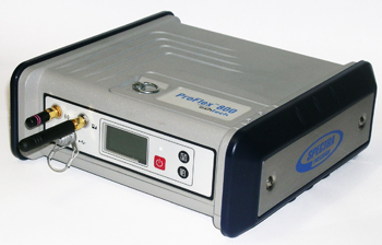
    Spectra Precision introduced the new ProFlex 800, a GNSS solution with Z-Blade GNSS-centric technology. The ProFlex 800 delivers fast and reliable RTK positioning, even in environments where GNSS signals may be difficult to acquire, Spectra Precision said. Rugged and IP67 rated, the ProFlex 800 is built to withstand harsh operating conditions for a variety of positioning applications.

    “The ProFlex 800 is an ideal solution for customers wanting a single GNSS receiver for multiple applications,” said François Erceau, general manager of Trimble’s Spectra Precision, Nikon and Ashtech Business Area. “It offers a unique design with a range of mounting and communications options.”

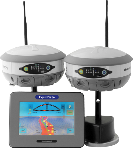
    Used as a backpack rover or reference station, the ProFlex 800 with Z-Blade technology is a flexible GNSS solution for land surveying. Its innovative design also makes it ideal for hard-mounted survey applications such as coastal work, dredging, bathymetry or offshore vessel operations.

    The weatherproof, high-impact-resistant molded aluminum housing allows the ProxFlex 800 to operate in harsh conditions.

    In addition to a 3.5G internal cellular modem, the ProFlex 800 can use a variety of internal or external UHF modules, providing stable and reliable wireless communications. It can be used as a rover or a base without additional accessories in the field. Its Z-Blade long-range RTK capability combined with industry-leading UHF options help to ensure maximum productivity while in the field.

    With its built-in Ethernet capability and embedded web server, users can access the ProFlex 800 from any computer connected to the Internet. This capability allows instant real-time multi-data streaming over an Ethernet connection to build an RTK corrections server without any additional software or equipment, the company said.

    Spectra Precision ProFlex 800 CORS Receiver. The Spectra Precision ProFlex 800 is also available as a Continuously Operating Reference Station (CORS). This configuration is an optimal solution when collecting, storing and transferring high-quality GNSS raw data for post processing surveys, geodetic and other applications. Automatic sessions programming, a user-friendly Web-interface, an embedded RINEX converter, FTP push functionality and many other advanced CORS features make the ProFlex 800 CORS a powerful, robust and easy-to-use GNSS solution.

    Advanced Ashtech Z-Blade Technology. Z-Blade is a new GNSS centric signal processing technology. Z-Blade uses all of the available satellite signals equally, without preference to any particular satellite constellation, maximizing the user’s ability to obtain reliable GNSS positions in tough conditions. Z-Blade allows users to receive and maintain RTK positioning even if GPS coverage is insufficient. In many work locations, just a few GPS and GLONASS satellites may be visible due to obstacles such as trees or buildings.

    The ProFlex 800 is now available through the Spectra Precision global dealer network. For more information visit: www.spectraprecision.com and www.ashtech.com or email: [email protected]

  • Trimble Introduces Receivers for GIS and Mobile Mapping

    Trimble has introduced the next-generation of its Trimble GPS Pathfinder family — the Trimble Pro 6H and Pro 6T receivers for GIS and mobile mapping. The Trimble Pro series with advanced features allows mobile workers to configure a solution for a wide range of applications, delivering flexibility in professional GIS data collection, Trimble said. The series offers a new streamlined form-factor and dramatic productivity improvements in difficult GNSS environments with Trimble Floodlight technology.

    The modular Trimble Pro series receiver gives users the flexibility to choose their setup configurations:

    • Optimized for use with Trimble data collection devices such as the Trimble Juno or Nomad G series handhelds, or Yuma tablet computer, the Trimble Pro series can also be used with other tablets and handhelds with NMEA output.
    • Real-time or postprocessed GIS workflows.
    • The receiver can be deployed in a backpack, on a pole or mounted on a vehicle.
    • Two models are available: the Trimble Pro 6H delivers decimeter accuracy, while the Pro 6T is the submeter model for standard GIS applications.

    “With the availability of the new Pro series receivers, data collection professionals now have access to the productivity-enhancements of Floodlight technology in both integrated and modular configurations,” said Daniel Wallace, general manager of Trimble’s GIS Data Collection Division. “While some prefer the convenience of an integrated, all-in-one handheld, others will appreciate the Pro series’ flexibility to choose from a range of data collection devices such as a high-resolution tablet or lightweight Trimble Juno.”

    Trimble Floodlight technology allows users to collect decimeter accuracy data in tough GNSS environments, Trimble said. Buildings and trees can cause satellite shadow and limit the environments where high-accuracy GNSS data collection can be performed. Trimble Floodlight technology combines a range of techniques to increase the availability of positions and boost accuracy in areas affected by satellite shadow. Using Floodlight technology, the Pro series can keep teams productive without compromising on accuracy. Users can work with fewer disruptions and ensure better data, faster data collection and higher field efficiency.

    Trimble Pro series receivers are rugged and built to withstand the rigors of long hours in tough outdoor conditions, yet optimized for high-accuracy GIS data collection workflows, Trimble said. For applications such as utilities inspections and timber stand valuations, Trimble Pro receivers provide long battery life and tough construction for dependable service over the course of rigorous data-collection projects.

    With its IP65 rating, the receivers offer reliable operation, even after prolonged exposure to water and dust, Trimble said. An integrated antenna reduces the complexity of the system for fast setup and swift data collection campaigns. Field workers can be up and running with minimal training, saving time and money. Combined with a Trimble handheld solution and Trimble TerraSync software, the complete system provides dedicated field workflows to simplify data collection and improve integration with the GIS for total workflow improvements.

    The new Trimble Pro 6H and 6T receivers are available from Trimble’s worldwide Mapping & GIS authorized distribution channel.

  • Snow Grooming Management System

    Snow Grooming Management System

    EquiPiste-with-S320

    Hemisphere GPS has announced the EquiPiste integrated snow grooming management system. EquiPiste provides visual guidance, snow depth status, and event logging for snow grooming operators, mountain managers and snow road operations. Ski resorts benefit from improved grooming quality and productivity, optimal snow making decisions and distribution, as well as more predictable and preventative snow cat maintenance, according to Hemisphere GPS.

    Snow grooming operations are tasked with creating quality snow conditions for ski trails or pistes, as they are referred to in the industry. Designed with an integrated touchscreen terminal and Crescent GPS, Hemisphere GPS’ EquiPiste graphically displays to the operator the areas groomed, boundaries, assets, points of interest, and hazards. Through the guidance cues, operators increase their efficiency and quality of work by avoiding overlaps and skips in grooming, Hemisphere GPS said. Areas that need attention such as thin snow pack and winch anchors can be flagged with meta-data so operators can easily navigate back at any time, even in low visibility. Pathways can be mapped and re-used for training novice operators or for repeatedly navigating snow roads. Operation managers benefit from reviewing the job files from each machine to determine variable costs, performance and maintenance tracking, the company said. As well, data can be mapped within Google Earth and used for generating daily grooming or road maintenance reports for customers.

    Many ski resorts also spend a substantial amount of their budget on snow making activities. When combined with Hemisphere GPS’ survey grade Eclipse GNSS technology, EquiPiste displays and records real-time snow depth measurements and maps, the company said. The snow depth data improves the efficiency and quality of managing the snow levels. The depth data helps indicate where and when to make snow, it alerts the operator to thin snow pack, where to redistribute snow as well as how to identically recreate (day to day and year to year) downhill race courses. Analysis of the snow depth data enables more optimized snow management.

  • GNSS Handheld Data Collector

    Nexteq Navigation, based in Calgary, Alberta, Canada, has announced the T5A, its new flagship multifunctional GNSS handheld data collector. The device is a high-accuracy GPS unit capable of 2-centimeter accuracy using real-time kinematic (RTK) and 50-centimeters globally using Nexteq’s i-PPP technology. With the T5A, users can achieve extremely accurate and consistent results anywhere in the world with no loss in flexibility, Nexteq said, adding that the unit’s centimeter-level precision coupled with versatility allows for accurate data collection in the most diverse weather conditions.

    Suitable for projects in all-environments, the T5A has a professional quality internal GPS receiver that provides accurate real-time results. Using Nexteq’s Freedom, i-PPP, or RTK technologies, the T5A data collector can provide flexible and accurate positioning in all parts of the world, Nexteq Navigation said.

    The T5A has a 3.7-inch color touchscreen that is both waterproof and dustproof. The device includes features such as Bluetooth, Wi-Fi, digital cellular data and voice, microSD card slots, and a 3.0 megapixel digital camera.

    Like all Nexteq Navigation GPS handhelds, the T5A is a ruggedized and tough unit. The T5A has an IP66 rating with excellent dust and water resistance.

  • Core Positioning Receiver Chip

    u-blox is launching the u-blox 7, its next-generation core positioning technology platform. Supporting all deployed as well as soon-to-be deployed GNSS, the platform is based on the UBX-G7020 multi-GNSS receiver integrated chip with low power consumption.

    With 7 mW power consumption during continuous navigation, u‑blox’ UBX-G7020 is designed for small portable and power-sensitive devices requiring long battery life, high sensitivity, small size, and fast positioning. GPS, GLONASS, Compass, Russian, QZSS, and Galileo satellite positioning systems plus all satellite-based augmentation systems (SBAS) are supported.

    “As the satellite systems expand beyond GPS, u-blox 7 is an important step for our customers to design systems that work with all available global navigation standards, particularly GLONASS which is now fully operational. Our multi-GNSS UBX-G7020 integrated circuit does exactly that while achieving two of the most important features that our customers demand: minimum power consumption and small size,” said Andreas Thiel, executive vice president of R&D Hardware and co-founder of u-blox.

    The chip has been designed to support the lowest cost stand-alone solution via minimum eBOM; only eight external components are required resulting in a receiver occupying only 30 mm2 on a two-layer PCB. Standard crystal and TCXO are supported. The chip also provides low-power, autonomous log data output of position, velocity, and time. Support for A-GPS and u-blox’ CellLocate hybrid GNSS/cellular positioning technology is embedded to facilitate advanced telematics applications including indoor positioning. Standard and automotive grade are supported.

    First samples of the multi-GNSS receiver chip UBX-G7020 are available for customer evaluation. Shortly afterwards, module customers can migrate to the MAX, NEO, and LEA form factors, u-blox’ module series which will all be upgraded to the new u-blox 7 platform.

    u-blox 7 maintains software compatibility with u-blox 5 and u-blox 6, and modules provide drop-in compatibility. Both previous generation platforms remain fully supported, the company said. u-blox’ capability of delivering GNSS technology in both integrated circuit and module form provides maximum design flexibility for a wide variety of applications. To evaluate the performance of the u-blox 7 multi-GNSS platform, evaluation kits supporting all u-blox 7 based chips and modules can be ordered.

  • Toolbox for GIS Location Data

    ikeGPS announced it has released its new toolbox, ikeTools, for rapidly capturing GIS location data and making measurements of complex objects from a remote location. Now you have the ability, right from your ikeGPS screen, to complete the most demanding field data capture jobs far more quickly and efficiently than ever before.

    ikeTools Data Capture Modes:

    Target Position: The work horse of ikeGPS mobile GIS data capture. Point ikeGPS at a remote object such as a tree, pole or building and capture its GPS location using the onboard GPS, laser range finder and compass. One shot and you’re on to the next object.

    Three Shot Height: Directly measure the height of an object, such as a pole, from a remote position, even when the base of the object is obscured.

    Missing Line: Calculate the horizontal distance between any two objects.

    Span Height: Calculate the vertical height above ground of a point on a span, for example the mid-span height of a cable or wire.

    Photo Only: Capture a high resolution photo of an object. Useful for documenting the conditions of located or measured objects, for identifying hazards for field crews and for including in assessments.

    True Size Poles: Capture a calibrated (TrueSize) photo of an utility or telecommunications pole with one shot, then transfer to a PC application for measuring the heights of the pole and its attachments.

    True Size PLS: Capture calibrated photos that are used on a PC to measure the heights of objects on electric utility poles. Exports directly to software products from Power Lines Systems, Inc.

    True Size UVM: A variety of measurements for utility vegetation management. Conduct Tree Assessments by measuring tree height, crown width, and trunk diameter at breast height (DBH).

  • Data-Collection Software

    Nexteq Navigation has release the newest version of its NexGeo software line-up: NexGeo Mobile, NexPos and NexGeo Office. Optimized for Nexteq handhelds, NexGeo Mobile integrates Nexteq Freedom, i-PPP, and RTK positioning augmentation technology into a more reliable, user-friendly data collection software, the company said. With easy display of features, background images, labeling and attributes, data is readily collected, accessed and edited. The tracking feature now allows for efficient communication and management between field workers and the office. Raw data recorded in NexGeo Mobile can be used for post processing in NexGeo Office.

    Those using third-party software with a Nexteq handheld are not left behind. NexPos was created with the intent of allowing freedom in benefitting from Nexteq position augmentation technology, the company said. The NexPos software acts as a bridge, applying Freedom, i-PPP, or RTK algorithms to GPS measurements. The final positions are transferred to third-party software via virtual COM port, allowing users to benefit from improved position accuracy while NexPos runs discreetly in the background. Raw data can also be recorded and used for post processing in NexGeo Office.

    On the desktop, NexGeo Office ties together collected data, attributes, and post-processing information to provide efficient project management capabilities, data organization, live field monitoring and integration with a wide variety of other software, Nexteq said. Building and maintaining a project specific database is easy using NexGeo Office: import existing data, build on the project using a Nexteq handheld and transfer it back to the office for editing. Exporting the project to ESRI or AutoCAD file formats allows for users to seamlessly continue expanding.

    NexGeo software suite is available and included with all Nexteq Navigation handhelds.