Tag: public safety

  • ACR Electronics Launches New Locator for Aviation

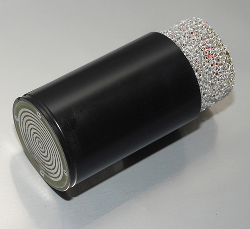
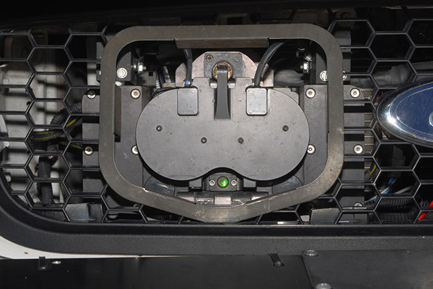
    A new emergency locator transmitter for aviation has received Cospas-Sarsat and FAA approvals and is now available for sale. The ELT 1000 by ACR Electronics, Inc., is designed with multiple installation configurations to reduce overall installation cost, the company said.

    The electronics maximize frequency stability and power while incorporating a new, built-in GPS navigational interface, the company said. Including GPS data in the emergency transmission allows search-and-rescue personnel to know the location within 100 meters in less than a minute. Designed to accommodate multiple installation configurations, the new ELT 1000 is a quick retrofit for obsolete 121.5 MHz ELTs.

    “We are very excited to announce this new ELT to the general aviation market. This is the first new ELT from the Artex family in many years and the first we have designed and certified at ACR. We feel we are bringing an ELT that offers excellent value, along with the highest quality workmanship available to the market,” said Gerald Angeli, president and general manager.

    Built under the exacting standards of AS9100C quality certification, the ELT 1000 exceeds all government and regulatory standards including the latest FAA guidelines with its new robust stainless steel mounting strap.

    ELT 1000 features and specifications:

    • Quick and easy retrofit for general aviation aircraft
    • Single antenna output for emergency transmission on both 406 MHz (Cospas-Sarsat) and 121.5 MHz frequencies (local Search & Rescue)
    • Enhanced positional accuracy with a built-in GPS interface that does not require aircraft power
    • Encoded digital message broadcasts aircraft identification/registration and owner/emergency contact details
    • New stainless steel mounting strap for increased stability that complies with the most current FAA guidelines
    • Simple self-testing from the cockpit. When combined with 406Test.com, the self-test will provide SMS/e-mail confirmation within seconds that the ELT signal reached the satellites successfully
    • New hermetically sealed G-Switch for increased reliability.
  • Azuga Takes on Distracted Driving for Fleet Managers


    To recognize National Safety Month and to highlight the growing dangers of distracted and reckless driving, Azuga has published a Fleet Stats infographic showing the dangers of auto accidents its fleet tracking programs are designed to prevent.

    Of the 41,000 Americans killed each year in traffic accidents, nearly 5,000 die as a result of crashes involving large fleet trucks. An additional 13,000 die as a result of a speeding-related accidents. Azuga offers two programs for fleet managers: SpeedSafe and DriveSafe.

    The programs combine GPS, a driver behavior and rewards system, vehicle health reports, and plug-and-play installation to combat reckless and distracted driving. DriveSafe prevents talking and texting when the vehicle is in motion. The distracted driving technology locks down a driver’s screen and only allows phone numbers that the employer’s policy allows. Policies can be applied at the individual driver level to allow certain calls and texts (for instance, allow incoming calls from home, the office, and school.)

    With SpeedSafe, a fleet manager controls speeding on residential streets, in school zones, and in adverse weather conditions. Going beyond simple control, a fleet manager also gets reporting and analytical tools to help quickly identify problem areas and track and train drivers over time.

    National Safety Month is sponsored by the National Safety Council. According to distraction.gov, using a mobile device while driving causes an estimated 28 percent of traffic accidents. Further, the National Safety Council estimates $40 billion cost to United States citizens each year.

    Azuga says its customers have been able to decrease the number of speeding events by 40 percent and decrease overall liability, which translates into an average 15 percent savings on insurance premiums.

  • Ethertronics Unveils GPS Helix Antenna for Mission-Critical Applications

    Ethertronics Unveils GPS Helix Antenna for Mission-Critical Applications

    EtherHelix GPS antenna.
    EtherHelix GPS antenna.

    Ethertronics has unveiled EtherHelix GPS, a small, stand-alone, Right Hand Circularly Polarized (RHCP) external GPS antenna. Measuring 35 mm in length, the EtherHelix GPS is 27 percent shorter than other antennas on the market with no performance trade-offs, the company said. It is designed for high-performance, mission-critical devices such as walkie-talkies, tough books, tough tablets, first responders, public safety, military applications and more.

    EtherHelix can be tuned for various satcom frequencies and various polarizations (RHCP or LHCP). EtherHelix GPS is designed using Ethertronics’ patented Isolated Magnetic Dipole (IMD) technology providing high performance and efficiency in a small form factor.

    EtherHelix GPS has a high tolerance to frequency shifts given the technology’s high RF isolation, which is designed to resist antenna detuning that can otherwise impair reception. EtherHelix GPS provides exceptional coverage inside buildings, vehicles or other areas where weak signals and signal reflection occur, the company said.

    “GPS capabilities are critical for first responders and military applications. It is imperative that the antennas used in these devices are high-performance, small and rugged,” said Olivier Robin, general manager Americas and Europe at Ethertronics. “EtherHelix GPS is the most recent example of Ethertronics’ leadership in developing industry-first RF solutions to provide manufacturers with a way to differentiate their products and stand out in a competitive market. Already we have seen interest in our new EtherHelix GPS antenna given its best-in-class performance coupled with its smallest occupied volume.”

    Given its reduced weight and size — 11.8 g and 35 mm long by 15 mm in diameter — manufacturers benefit from simpler integration for an array of GPS devices, Ethertronics said. In addition, the new GPS antenna’s capabilities include high selectivity, which minimizes the need for additional filters. EtherHelix GPS’s ruggedized design includes IP-68 protection from dust and water, as well as a standard SMA male connector for easy integration. The RoHS Compliant antenna is designed and manufactured in the United States.

    EtherHelix GPS is commercially available now and is the first in a series of antennas for mission-critical applications.

  • Public Safety Organizations Support FCC Rule to Help Find Wireless 911 Callers

    Many of the nation’s leading public safety and public health organizations submitted comments this week in support of a proposed Federal Communications Commission (FCC) rule to help emergency responders more quickly and accurately find 911 callers using wireless phones from indoor locations.  More than 300 individuals and organizations filed during the initial comment period with the overwhelming majority supporting the FCC proposal.

    Among those supporting the rule were many of the largest and most respected organizations representing 911 professionals, police officers, fire fighters, EMS workers, public safety professionals, older Americans, heart attack and Alzheimer’s patients, and the deaf and hard of hearing.  They were joined by hundreds of individual 911 dispatchers and first responders who submitted personal comments through the FCC’s web site or in survey responses that were filed with the FCC.

    “The support for this rule across the public safety and public communities is truly breathtaking,” said Jamie Barnett, director of the Find Me 911 Coalition and former chief of the FCC’s Public Safety and Homeland Security Bureau. “These organizations are on the front lines of emergency response, and they know that lives are being lost every day because 911 professionals cannot quickly find indoor callers using wireless phones.  The urgency of this rulemaking is unquestionable, and we commend Chairman Wheeler and the other commissioners for their leadership by taking fast action on it.”

    According to the FCC’s estimates, at least 10,000 lives a year could be saved by improvements in response time through the FCC’s proposed rule. All of the comments submitted are online.

    Find Me 911 is an effort supported by more than 200,000 individuals, as well as national and local organizations. The individuals and organizations represent a broad range of 911 operators and first responders — emergency medical services personnel, fire fighters and police. Find Me 911 seeks to ensure that the FCC moves forward quickly to establish a reasonable, measurable level of location accuracy for emergency calls made indoors, enabling first responders to locate emergency calls from wireless phones from all locations rapidly and efficiently.

    Among the organizations filing joint or individual comments in support of the FCC’s proposed rule were:

    • Law Enforcement
    • International Association of Chiefs of Police
    • National Sheriffs’ Association
    • Fire Fighters
    • International Association of Fire Fighters
    • International Association of Fire Chiefs
    • Emergency Medical Professionals
    • National Association of State Emergency Medical Services (EMS) Officials
    • National Association of EMS Physicians
    • National Association of EMTs
    • National EMS Management Association
    • American College of Emergency Physicians
    • 9-1-1 Professionals
    • National Association of State 911 Administrators
    • National Emergency Number Association
    • Association of Public Safety Communications Officials
    • CALNENA
    • Texas 9-1-1 Alliance
    • Texas Commission on State Emergency Communications
    • [Texas] Municipal Emergency Communication Districts Association
    • San Francisco Department of Emergency Management
    • Nebraska Public Safety Commission
    • Older Americans
    • AARP
    • Alliance for Retired Americans
    • Public Health
    • Alzheimer’s Association
    • American Heart Association
    • Public Safety
    • National Association of Regulatory Utility Commissioners
    • National Public Safety Telecommunications Council
    • Deaf and Hard of Hearing
    • Telecommunications for the Deaf and Hard of Hearing
    • National Association of the Deaf
    • Association of Late-Deafened Adults
    • Cerebral Palsy and Deaf Organization
    • California Coalition of Agencies Serving the Deaf and Hard of Hearing

    Deaf and Hard of Hearing Consumer Advocacy Network

    Technology Access Program, Gallaudet University


  • Applanix, American Aerospace Partner on Mapping for UAVs

    Applanix, American Aerospace Partner on Mapping for UAVs

    AAAI-Applanix-system
    photo: AAAI

    Applanix Corp. and American Aerospace Advisors, Inc. (AAAI), have agreed on an OEM supply agreement that will incorporate Applanix direct georeferencing technology into AAAI’s unmanned aerial platforms. The collaboration creates a commercially available professional-grade mapping UAV system for civilian applications such as pipeline monitoring, power line surveys and emergency-response mapping.

    The availability of the system follows a series of successful test flights of AAAI’s RS-16 Unmanned Aircraft System equipped with Applanix’ DMS-UAV aerial photogrammetry payload with commercially available inertial technology. Joint teams from Applanix and AAAI planned and flew a sequence of missions to evaluate the capabilities, including the ability to provide highly accurate, directly georeferenced and orthorectified aerial imagery without the need for ground control points or aerial triangulation calculations.

    The system — consisting of the airframe, its avionics, mobile ground control station, telemetry systems and the digital mapping payload — performed according to expectations and successfully produced high-quality imagery.

    The announcement was made at AUVSI’s Unmanned Systems 2014 Conference in Orlando Florida, where the most comprehensive collection of unmanned systems for every domain – air, ground and marine – are on display. A video of the system can be watched here.

    “The OEM supply agreement with Applanix formalizes our plans to transform the aerial mapping industry by creating an integrated, professional-grade mapping system for unmanned flight,” David Yoel, CEO of American Aerospace Advisors, said. “For civilian aerial survey projects, this can mean safer operations, lower costs and more efficient deployments while still delivering very high accuracy. We are very pleased to announce the availability of the RS-16 Direct Mapping Solution.”

    “We believe this is a ground-breaking development for the airborne imaging systems market,” Joe Hutton, Director of Inertial Technology and Airborne Products at Applanix, said. “There has been a lot of attention on developing a commercial, directly georeferenced mapping solution for UAVs, and now it is a reality.”

    The RS-16 with the Applanix DMS payload is available through American Aerospace Advisors directly, for sale to jurisdictions where it is permitted to fly civilian UAV systems.

  • Omnilink Offender Monitoring and Asset Tracker Now on Verizon Network

    Omnilink, a provider of advanced machine-to-machine (M2M) tracking and monitoring solutions, has been named to the Verizon Partner Program as a Silver member.

    “U.S. government agencies, businesses, and consumers have depended on Omnilink to monitor the location, safety, and condition of offenders, assets, vehicles, loved ones, fleets, employees, and much more since 2004,” said Steve Hudson, Omnilink’s chief development officer. “We help businesses track and monitor virtually anything on almost any device, and set high standards in reliability, accuracy and ease of use. And now we are excited to make these solutions available to Verizon customers.”

    Omnilink FocalPoint Offender Monitoring is an advanced electronic monitoring solution that gives government agencies the ability to reliably track and monitor the location and status of their entire offender caseload across the U.S. on virtually any device. FocalPoint Offender Monitoring combines reliable GPS/AGPS/AFLT/RF hardware, the friendliest software, comprehensive 24/7/365 support services, and state-of-the-art-infrastructure for complete offender supervision.

    Omnilink Asset Tracker helps companies better manage their assets with an award-winning asset optimization, theft prevention, and monitoring and safety solution. Asset Tracker is an all-in-one asset tracking system that gives companies the ability to track and monitor the location and condition of all their physical assets—vehicles, trailers, equipment, retail, ATMs, bank bags, goods in transit, and much more — across the U.S. and beyond via their computer, tablet, and smartphone.

    The Verizon Partner Program tailors regional and national opportunities for systems integrators, value added resellers, agents and solutions providers to accelerate delivery and adoption of solutions for meeting medium business requirements. In addition, the program features a tiered benefits structure that allows members the flexibility to determine levels of commitment, and also includes simple-to-use tools and clear and consistent engagement processes.

    Verizon Enterprise Solutions creates global connections that generate growth, drive business innovation and move society forward. With industry-specific solutions and a full range of global wholesale offerings provided over the company’s secure mobility, cloud, strategic networking and advanced communications platforms, Verizon Enterprise Solutions helps open new opportunities around the world for innovation, investment and business transformation.

  • Handheld Launches Nautiz X4 Rugged Computer for Mobile Workers

    Handheld Launches Nautiz X4 Rugged Computer for Mobile Workers

    Handheld-Nautiz-X4-rugged-IP65-W
    photo: Nautiz X4

    Handheld Group, a manufacturer of rugged mobile computers and smartphones, has launched the Nautiz X4 rugged handheld. The Nautiz X4 is a multipurpose compact handheld computer built for the mobile worker. It enables efficient and reliable data collection in the toughest environments, the company said.

    The Nautiz X4 is a compact and lightweight rugged handheld computer that is optimized for efficient field data collection. It has been designed and developed specifically for mobile workers in tough environments in industries such as warehousing, logistics, transportation, utility, field service, security and public safety.

    The Nautiz X4 rugged handheld computer has an integrated u-blox GPS receiver that provides professional-grade navigation functionality. It also offers multiple connectivity options, such as high-powered 3G and excellent Wi-Fi capability, the company said. It has a high-speed 1-GHz processor, 512 MB of RAM and 1 GB of flash memory. It runs Windows Embedded Handheld 6.5.

    Measuring 156 x 74 x 25.5 millimeters (6.1 x 2.9 x 1.0 inches) and weighing 330 grams (11.6 ounces), the Nautiz X4 is an ergonomic work tool and one of the thinnest and lightest handheld computers in the rugged-device sector, the company said. It features a high-brightness, sunlight-readable resistive touchscreen for reliable computing in challenging worksite environments, and comes with either a high-performance 1D laser scanner or a 2D imager for fast, accurate scanning and barcoding tasks. The device also features a 5-MP camera with auto focus and LED Flash.

    The Nautiz X4 has an IP65 Ingress Protection rating, which means that it is impervious to dust and highly resistant to water — the unit can be used in dusty work environments as well as in heavy rain, and can be rinsed off if dirty. It also meets stringent MIL-STD-810G military test standards for overall durability and resistance to humidity, shock, vibration, drops, salt and extreme temperatures.

    “Mobile data collection is performed in warehouses as well as outdoors, in all kinds of weather and for long work hours. It may be cold and it may rain or snow. So the field worker needs a computing tool that can not only handle adverse weather conditions, but is also ergonomic and user-friendly,” said Jerker Hellström, CEO of Handheld Group. “For this, we are proud to introduce the Nautiz X4, a new rugged handheld computer that merges ultimate mobility with true field functionality in a handy package and at a very attractive price. We are confident that the Nautiz X4 will be the obvious choice for mobile workers in a wide range of industries.”


  • McMurdo Group Offers Suite of Automatic ID Systems for Boating

    McMurdo Group Offers Suite of Automatic ID Systems for Boating

    McMurdo
    Boatracs, Kannad, McMurdo and TSi have combined to form McMurdo Group, a single-vendor provider of end-to-end search and rescue, maritime domain awareness solutions.

    McMurdo Group has announced a suite of Automatic Identification System (AIS) survival solutions for enhanced collision avoidance and man overboard (MOB) response in the U.S. recreational boating market. The offerings include AIS beacons, transponders, receivers and software.

    AIS is an automatic tracking system used on boats and ships that identifies and tracks nearby AIS-equipped vessels and devices to help avoid collisions. AIS transponders send and receive critical navigation information – such as vessel identification numbers, vessel type, position, course and speed – and graphically display a map of the surrounding vessels and area. AIS receivers are often used in conjunction with AIS-capable computer software for similar tracking and monitoring purposes.

    In the event a person with an AIS MOB beacon falls overboard, an AIS signal from the beacon is activated. This signal is then sent to AIS receiving devices where the location of the individual in the water can be pinpointed using GPS positioning and presented on graphical chart maps.

    The Smartfind M5 has an on-screen beacon location indicator and audible alarm that is triggered to accelerate rescue efforts. It also has a “buddy list” feature that can identify the specific individual needing MOB assistance. For larger fleets, the McMurdo Group AIS Alarm Notification System extends graphical mapping, alarm notification and messaging capabilities to shoreside fleet management operators.

    The McMurdo Group AIS product suite includes the following:

    • AIS Search and Rescue Transponders (SART) or Beacons
      • Smartfind S5 – a compact, lightweight, waterproof (to 10 meters) AIS SART with high-visibility buoyant carry-off bag ideal for use on life rafts or survival crafts.
      • Smartfind S10 – a personal, waterproof (to 60 meters) AIS Man Overboard (MOB) device with built-in flashing light and used by individuals or as an additional device to complement a yacht’s on-board flare pack.
      • Smartfind S20 – a compact AIS MOB device with integrated light for use in a lifejacket.
    • AIS Transponders and Receivers
      • Smartfind M5 AIS Class A Transponder – the industry’s first AIS Class A transponder with color display and AIS MOB and AIS SART alarm with crew list functionality to aid in MOB recovery.
      • Smartfind M10 AIS Class B Transponder – typically used for smaller vessels, charter boat operators or where the additional features of an AIS Class A transponder are not required (includes an a 30 day data logger).
      • Smartfind M15 AIS Receiver – economical AIS receiver for all recreational  vessels.
    • AIS Software
      • PC Viewer – Graphical software package ideal for individual vessel operators (included with the Smartfind M5, M10 and Smartfind M15 products).
      • AIS Alarm Notification System  – Vessel Monitoring System with integrated AIS MOB Alerts and Messaging typically used for ship-to-shore communications.
  • STMicroelectronics’ Chips Ready for Galileo eCall Approval

    Teseo-ecall
    The Teseo II chip is ready for eCall, a European initiative intended to bring rapid assistance to motorists involved in a collision anywhere in the European Union.

    STMicroelectronics, a global semiconductor company, has released its Teseo II single-chip satellite-tracking integrated circuit to the European Space Agency (ESA) and the European Commission Joint Research Center (JRC) for testing for eCall approval. The testing campaign is coordinated by the European GNSS Agency as part of its effort to accelerate Galileo adoption.

    The Galileo tests will be conducted by the ESA and JRC over the next months to validate ST’s latest firmware release, according to the European GNSS Agency (GSA) test plan. The testing campaign supports the upcoming Galileo early operational services that are expected to go live at the end of 2014. In addition, the tests will evaluate Teseo II compatibility with the European Geostationary Navigation Overlay Service (EGNOS) and with Galileo for the eCall in-vehicle system that automatically sends notification messages from vehicles involved in an accident. Beside static and dynamic test conditions, the testing plan foresees three different use cases, in systems for single-, dual-, and up to triple-constellation (GPS/Galileo/GLONASS) systems.

    Following the first position fix using Galileo in-orbit validation satellites conducted by ST and ESA in March 2013, STMicroelectronics has implemented the Galileo Golden-candidate production firmware as an additional constellation in its Teseo II chips. While the Teseo II ICs have always had the capability to be Galileo-ready, ST is enabling a firmware update from the Galileo navigation system. This update benefits consumers and doesn’t require any hardware modification.

    The Teseo II chips can simultaneously use signals from multiple satellite navigation systems, including the currently available Galileo satellites, and progressively, as future satellites are launched, the full satellite constellation.

    ST’s leadership in the multi-constellation reception delivers immediate use of the Galileo satellites already in orbit, and provides consumers with shorter time-to-first-fix, continuous tracking with enhanced accuracy, and effective operation under challenging circumstances, such as driving through urban canyons.

    In January, GPS World published a cover story on the next-generation Teseo-3 chip, which also provides background on the development of the Teseo II.

    Introduced in January 2011, ST’s Teseo II is a standalone satellite receiver able to use signals from multiple satellite navigation systems, including GPS, the European Galileo system, Russian GLONASS, and Japanese QZSS. This multi-constellation approach keeps many satellites in sight, delivering advantages such as shorter time-to-first-fix and continuous tracking with enhanced accuracy, even under challenging circumstances such as driving through urban canyons.

  • Applanix Conducts Successful Test Flight of Professional Mapping UAS

    Applanix Conducts Successful Test Flight of Professional Mapping UAS

    Applanix_UAV3

    Applanix Corporation and American Aerospace Advisors have completed a successful series of test flights of AAAI’s RS-16 platform equipped with Applanix’ DMS-UAV aerial photogrammetry payload. This is the first successful mission for a long-endurance UAS (unmanned aerial system) capable of producing professional-grade, directly georeferenced mapping imagery for civilian applications such as pipeline monitoring, power line and emergency response mapping.

    The RS-16 Unmanned Aircraft System equipped with the Applanix Direct Mapping Solution (DMS).
    The RS-16 Unmanned Aircraft System equipped with the Applanix Direct Mapping Solution (DMS).

    Tests were conducted over restricted airspace in the state of New Jersey. A joint team from Applanix and AAAI planned and flew a sequence of missions to evaluate the capabilities of the UAS. These include, critically, the ability to provide highly accurate, directly georeferenced and orthorectified aerial imagery without the need for ground control points or aerial triangulation calculations. The system, consisting of the airframe, its avionics, mobile ground control station and the digital mapping payload, performed according to expectations and successfully produced high-quality imagery.

    “Performing safe and successful missions with long endurance unmanned aircraft in civilian airspace are a challenge that goes far beyond selecting the right aircraft and payload,” said David Yoel, CEO of American Aerospace Advisors. “Working with Applanix, we have produced an integrated system that is designed from the ground up with civilian mapping operations in mind. We believe this system has the capability to transform the aerial mapping industry.”

    The Applanix R16 in flight.
    The Applanix RS-16 in flight.

    The RS-16 DMS is a complete, operational system capable of conducting large area operations within the National Airspace System in the United States, and in other jurisdictions as local regulations allow. Within the USA, AAAI is engaged with several of the recently announced UAS research and test sites, which operate under the auspices of the FAA to develop the certification and operational requirements necessary to safely integrate UAS into the national airspace.

    The GNSS-Inertial systems at the core of Applanix’ DMS-UAV aerial mapping payload uses commercial inertial technologies that are offered globally.

    “The market for airborne imaging systems is in a state of rapid change,” said Joe Hutton, director of Inertial Technology and Airborne Products at Applanix. “Developments in imaging technology, in processing capability, and in the nature of inertial sensors, make a directly georeferenced UAS a reality today, where it would have been inconceivable even a few years ago. Our ability to take our established market-leading manned solutions, and integrate the technology successfully into an unmanned platform, speaks  volumes for the engineering expertise of Applanix and AAAI.”

  • Hemisphere GNSS Launches GeoMapper Mobile Handhelds and GIS Software

    Hemisphere GNSS Launches GeoMapper Mobile Handhelds and GIS Software

    Photo: Hemisphere GNSS
    Photo: Hemisphere GNSS

    Today, Hemisphere GNSS announced an all-new series of rugged mobile handheld devices with application software options to support survey, GIS, and mapping professionals. GeoMapper handhelds are designed to work in harsh outdoor environments and features an intuitive and scalable software package.

    The GeoMapper family of products (GM100, GM200, GM300, and GM500) offers a variety of features also suitable for forestry, public safety, asset management, utilities, meeting a variety of field data collection requirements. GeoMapper 100, GeoMapper 200, and GeoMapper 300 feature a Windows Mobile operating system. The GeoMapper 500 tablet offers added flexibility and functionality on the Android OS platform. All GeoMapper models provide high-resolution and direct-sunlight-readable display technology for ease of visibility in all situations.

    The GeoMapper 300 has dual cameras and a unique built-in laser range capability for acquiring instant geo-referenced images and target location data. Both GeoMapper 300 and GeoMapper 500 feature Hemisphere’s high-accuracy, multi-GNSS, multi-frequency Eclipse RTK technology as standard. All GeoMapper handhelds are IP65 rating or higher for their enclosures to ensure durability in most outdoor environments.

    All GeoMapper handhelds feature a newly developed, user-friendly, and scalable GeoMapper Mobile software package designed for professional Field Mapping and GIS applications. GeoMapper Mobile and GeoMapper Office products feature optional post-processing and RTK positioning capabilities to meet the needs of the most demanding professionals.

    “Hemisphere has made substantial investments in expanding our Survey and GIS product portfolio, leveraging our unique capabilities of designing GNSS receivers, antennas, and handheld computing technology from our parent company, providing our customers with exceptional value,” said Phil Gabriel, president of Hemisphere GNSS. “Leveraging our 23 years of GNSS development experience with the latest in handheld technology is a natural and exciting next step for us.”

    In February 2013, Hemisphere GPS changed its name to Hemisphere GNSS Inc. after parting ways with the Agriculture business unit (Now AgJunction Inc.). While both Hemisphere names are owned by the company, in order to reflect the company’s support of all Global Navigation Satellite Systems (GNSS) and update the company’s image, Hemisphere GNSS Inc. has adopted the use of a new logo and launched a new website.

    Hemisphere GNSS will be introducing the new GeoMapper series at the annual Intergeo conference in Essen, Germany, October 8-10, 2013 at booth #A3.070.

  • StarChase Uses GPS for Safer Police Pursuits

    StarChase Uses GPS for Safer Police Pursuits

    Thousands of high-speed pursuits by law enforcement take place in the U.S. every year, which can endanger other vehicles and property. A new product aimed at law enforcement is designed to help police track cars during these high-speed chases.

    The StarChase system pursuit reduction technology contains a miniature GPS module encased in a tracking projectile/tag and a launcher mounted on a police vehicle. During a pursuit, a GPS tracker tag is shot with compressed air out of a patrol car’s hood onto the car being pursued, to identify the vehicle.

    The compressed-air launcher, mounted behind the grille of a police cruiser, uses a laser to target the fleeing vehicle. It discharges a projectile/tag containing the GPS module. The projectile adheres to the suspect vehicle and transmits coordinates back to dispatch. The dispatcher then views the location and movements of the tagged vehicle in near real-time on a digital road map via a secure Internet connection.

    Through the efficient use of technology, a high-speed chase has been replaced with a safer interdiction strategy, according to the company.

    The StarChase mapping platform is a secure, scalable Web-based solution that does not require special hardware to operate. It is compatible with existing CAD and AVL systems.

    The StarChase compressed air launcher under the hood.
    The StarChase compressed air launcher under the hood.
    The StarChase projectile.
    The StarChase projectile.
    Tagged vehicles are tracked by dispatch.
    Tagged vehicles are tracked by dispatch.