Tag: Russia

  • Todd Humphreys: Russian satellites a cause of GNSS jamming across Europe

    Todd Humphreys: Russian satellites a cause of GNSS jamming across Europe

    Russian satellites have caused GPS outages of as long as 10 seconds across Europe, according to a new research paper, authored in part by GNSS expert Todd Humphreys.

    Humphreys is head of the Radionavigation Laboratory at the University of Texas at Austin. Separate research by Richard Bowden at Spanish company GMV supports the findings, according to The New York Times.

    In at least three of 75 instances identified since 2019, the interference originated from as many as three Russian satellites. The other cases implicate the same Russian early-warning network; though data is insufficient to pinpoint the source, the same type of signal was identified.

    Whether Russia knows of the interference — and its motives — is unknown, but the signals disrupt GPS, Galileo and BeiDou, and not Russia’s own GLONASS. The press office for the Russian Embassy in Washington, D.C. told The Times it had no comment.

    The paper, “Chasing Lightning: Detecting, Characterizing, and Identifying a Powerful Space-Based GNSS Interference Source” by Zachary L. Clements, Argyris Kriezis and Todd E. Humphreys, can be accessed here.

    The paper provides a comprehensive analysis of the GNSS interference phenomenon: wide-area transient interference from a space-based source causing up to 10-dB GNSS degradation across Europe since 2019 in the L1 band. The interference’s spatial, temporal and spectral properties are detailed. The researchers designed a framework to detect events using 1-Hz carrier-to-noise ratio observables from a network of 165 reference stations.

    The three satellites implicated in the interference are part of Russia’s Edinaya Kosmicheskaya Sistema (EKS) constellation, which detects missile launches and nuclear explosions around the world. The first instance of this widespread jamming was recorded in October 2019, a month after the first EKS satellite was launched.

    These cases are among the first known examples of GPS interference originating from space. Two historic cases of satellite interference were caused by technical glitches.

  • Russian sabotage of Baltic Sea states is analyzed in a new white paper

    Russian sabotage of Baltic Sea states is analyzed in a new white paper

    Russian acts targeting critical infrastructure, satellite signal interference paralyzing maritime and air navigation, and cognitive operations aimed at intimidating European societies are examples of Russian hybrid activities targeting the Baltic Sea region states.

    The paper, “White Paper on Russian Acts of Sabotage and Subversion against Members of the Council of the Baltic Sea States,” can be downloaded here. Authors Filip Bryjka, Anna Maria Dyner and Aleksandra Kozioł are with the Polish Institute of International Relations.

    The report explores GNSS signal disruptions in the Baltic Sea and how it affects the safety of maritime and air traffic.

    Scale and Methods of Russian Operations

    Since the beginning of the full-scale invasion of Ukraine, Russia has intensified its hybrid activities against NATO member states, particularly those that have most actively supported Ukrainian resistance. This group includes the members of the Council of the Baltic Sea States. It is against them that the vast majority of acts of diversion and sabotage recorded in Europe since February 2022 have been directed.

    Russia deploys a full spectrum of tools against the region:

    • Acts of diversion and sabotage targeting critical infrastructure.
    • Border incidents: Violations of airspace and maritime borders.
    • GNSS signal disruptions (satellite radio transmissions), creating operational problems for maritime and air navigation.
    • Cognitive influence, aimed at causing measurable damage, testing state responses, and inducing a sense of growing threat among societies.

    Recommendations: How to Counter Hybrid Threats?

    The offensive nature of Russian actions demonstrates an intent to destabilize NATO and EU countries. Effective defense requires developing shared mechanisms:

    • Close cooperation among agencies: Ensuring a high level of situational awareness through the coordination of activities (at both national and international levels) among military and civilian intelligence, counterintelligence, border guard services, and the police.
    • A dedicated information exchange system: Leveraging the geographical proximity and potential of the CBSS states to quickly share threat data.
    • Unambiguous attribution of persuasions: Publicly naming Russia as the author of the attacks. A lack of clear attribution hinders coordinated preventive and retaliatory measures.
    • A catalog of best practices: Developing common rules for monitoring, reporting, and responding to known and repetitive Russian operational patterns.

    The authors conclude that only a full spectrum of coherent measures taken by all states in the region, alongside NATO and EU structures, can effectively influence Russia and reduce the risk of future incidents.

  • RQ-170 stealth drones tied to Venezuela operation as FCC bans foreign UAV imports

    RQ-170 stealth drones tied to Venezuela operation as FCC bans foreign UAV imports

    As the news subsides on the U.S. operation in Venezuela to capture Nicolás Maduro and his wife, attention is now turning to the legal aspects of the prosecution. Nevertheless, this military undertaking was apparently extremely complex and involved very discreet initial persistent surveillance of not only Maduro’s location but also of a large number of military installations and facilities.

    Venezuela has acquired an extensive arsenal of sophisticated Russian air defense capabilities beginning in 2011 and which were apparently recently upgraded in 2024. Heavy damage during the U.S. operation at La Carlota Air Base in Caracas, Fort Tiuna Military Complex, La Guaira Port and El Higuerote Airport appears to have overcome not only surface-to-air anti-aircraft missile systems but also Su-30 Sukhoi Flanker fighter aircraft armed with air-to-air missiles.

    And how was this accomplished? Well, likely with the help of legendary Lockheed RQ-170 Sentinel Stealth Drones. Nothing in the classified operation has been positively confirmed, but it is known that one or two of these surveillance drones were videoed returning to Naval Station Roosevelt Roads in Puerto Rico in the early morning of Jan. 3 following the U.S. attack. And piecing together earlier photos of U.S. Latin American command with an RQ-170 operations operative, pundits now believe confirm RQ-170 involvement.

    Lockheed RQ-170 stealth drone, nicknamed Wraith (Photo: USAF)
    Lockheed RQ-170 stealth drone, nicknamed Wraith (Photo: USAF)

    The 30th and 44th Reconnaissance Squadrons at Wing at Creech Air Force Base in Nevada are the only units the Air Force has confirmed to be operating RQ-170s Wraith low-observable stealth drones.

    It’s therefore quite possible that when President Trump said, “I was able to watch it in real time, and I watched every aspect of it,” that the video link may have been supplied by one or more of the RQ-170 Wraith drones circling over the action on the ground.


    Another aspect of the Venezuelan operation comes from people on the ground in Caracas who reported a number of instances of “flying bombs” which fell on targets during the U.S. operation. Video clips and numerous personal accounts apparently supported the reports that prop-powered attack drones were being crashed into ground targets, followed by big explosions.

    And previously on Dec. 16, the U.S. had a “first” for the U.S. Navy to have launched a one-way attack drone from the deck of the USS Santa Barbara in the Arabian Gulf. These earlier reports indicated that these attack drones could be launched by catapult, using rocket assist and from mobile ground vehicles.

    Therefore, it is not much of a leap to say it’s very likely that other marine and ground launch facilities in and around Venezuela dispatched many one-way, likely semi-autonomous attack-drones to take out targets prior to Delta Force being helicoptered in to capture Madura.


    Meanwhile back in the U.S., well away from military action, the Federal Communications Commission has effectively banned the sale of any new UAS or parts for UAS being imported into the U.S. The ruling was developed after the White House initiated a review aimed at protecting American security which decided “that UAS and UAS critical component parts that are produced in foreign countries pose unacceptable risks to the national security of the United States and to the safety and security of U.S. persons.”

    To somewhat clarify the situation, the FCC just added exemptions for Pentagon-approved “Blue List” drone models and parts thereof from EagleNXT, Parrot, Teledyne FLIR, Neros Technologies, Wingtra, Auterion, ModalAI, Zepher Flight Labs and AeroVironment — imports from these suppliers will be allowed through the end of 2026.

    So with new models of foreign drones being prevented from entering the U.S., the U.S. drone industry has been granted, at least for the moment, an opportunity to develop leading UAS models which will eventually outpace existing foreign drones operating in the U.S. It’s predicted that the FIFA soccer World Cup this summer will need a lot of drone coverage for security purposes — possibly a new U.S. drone home market.


    The Bell-Boeing V-22 Osprey is a complex military tilt-rotor aircraft which overcame many hurdles in its development and initial operations phase, even having some incidents during its mature field operations.

    Bell-Boeing V-22 Tilt-rotor aircraft (Photo:  Boeing)
    Bell-Boeing V-22 Tilt-rotor aircraft (Photo: Boeing)

    Nevertheless, the Chinese appear to have adopted a similar design approach for the Lanying R-6000 manned/unmanned tilt-rotor 6-12 passenger eVTOL and a 2-ton-cargo transport version. The promotional video for the Chinese United Aircraft R-6000 seems to interchange shots of the V-22 in hover mode with recent R-6000 prototype system in hover flight. However, Bell-Boeing web statements disclaim any linkage with the Chinese company or its R-6000 development.

    If the name “United Aircraft” seems familiar, it’s because there was such a company in the U.S. in the 1930s, changing its name to United Technologies (Pratt & Whitney) in 1975, now RTX Corp.

    United Aircraft in China has apparently been around since 2012 and has produced a number of vertical lift aircraft, including the TD220 twin-coaxial helicopter (without tail boom). As with most large industrial companies in China, this one also seems heavily engaged with the Chinese military and is now making inroads into the civilian marketplace with a number of UAVs for various applications, leading up to the projected 550 mph Lanying R-6000, which has been depicted in low-level flight mode.

    Promotional image of eVTOL Lanying R-6000. (Photo: United Aircraft)
    Promotional image of eVTOL Lanying R-6000. (Photo: United Aircraft)

    So, a mixed bag of unmanned aircraft reports this month, ranging from drones likely used in the recent U.S. action in Venezuela, FCC rulemaking to restrict imports of foreign UAVs into the U.S., and all the way to a new potential Chinese tilt-rotor eVTOL entrant.

  • NASA preps Mars helicopter as war shapes defense tech future

    NASA preps Mars helicopter as war shapes defense tech future

    It’s always good news when we hear about NASA’s “out-of-this-world” next steps toward building a replacement for Ingenuity, the small Mars helicopter-drone. With 72 flights over 1,004 days, Ingenuity outlived NASA’s expectation of just 30 operational days on Mars. It ended up serving as a trailblazer for the SUV-sized Perseverance rover as it worked its way around Jezero Crater. Built with a large number of smartphone components, it’s actually amazing that this thing survived for so long, given the radiation environment on the surface of Mars, along with the harsh temperature extremes of daytime 32°F to nighttime minus 130°F. How a Samsung S5 phone battery survived, operating so far outside its design temperature range, is hard to fathom.

    NASA’s 20-year plan for future Mars exploration now looks to take advantage of the huge expansion of the envelope for exploration that the small 30-day Mars helicopter brought to the Perseverance mission: “Enhanced mobility systems will enable exploration of challenging terrains and increased operational range. Aerial mobility technologies will facilitate access to previously unreachable areas on Mars.”

    NASA drone flies over ‘Mars Hill’ in Death Valley during recent navigation tests (Photo: NASA/JPL)
    NASA drone flies over Mars Hill in Death Valley during recent navigation tests. (Photo: NASA/JPL)

    So now NASA is working on the next Mars rover mission and on improvements for its accompanying airborne support. A team recently took three commercial drones into Death Valley to work on overcoming navigation problems that Ingenuity encountered on Mars flying over “bland” terrain with few visual features for its optical navigation system. Sand dunes without features on Mars messed with Ingenuity’s navigation solution, including on its 72nd flight.

    Death Valley and Mesquite Flats Sand Dunes were two places the NASA team visited to test improved navigation algorithms installed on existing commercial drones, and they found some improvements by adding camera filters. The new software helped find landing spots in cluttered terrain.

    But now new initiatives are seeking ways to get crewed flights to Mars in the next couple of years, well ahead of NASA’s timetable, which doesn’t move to anything crewed until around 2030. NASA still seems to prefer to pursue landers to gather much more data on Mars before risking crewed flights. Robotic dogs are also being investigated that can traverse rugged uphill areas that landers cannot access, as well as a winged glider the size of a small school bus.


    Meanwhile, the never-ending Russia-Ukraine war rages on, dominated by drone attacks from both sides. Russia is increasingly using Iranian Shahed or the equivalent Russian-produced Geran-2 one-way drones, while Ukraine intercepts them with low-end modified commercial drones. This stalemate has $20,000 Geran-2 drones being brought down by high-speed interceptor drones built for $2,000 to $6,000 — in other words, the cost of attrition might determine the victor.

    Russian Geran-3 jet-powered drone downed by Ukraine. (Photo: DIU)
    Russian Geran-3 jet-powered drone downed by Ukraine. (Photo: DIU)

    However, Russia has now introduced a jet-powered Geran-3 model that flies at up to 230 mph, which Ukraine has apparently been able to bring down.

    As we well know, Ukraine not only regularly receives Western military equipment but also civilian drones in large numbers. But an industrial capability has also been created in Ukraine to design, develop and build high volumes of drones. So it’s not surprising that Ukraine has revealed its own interceptor drone known as Sting.

    STING interceptor drone and imagery striking a Shahed drone. (Photo: Wild Hornets Group)
    STING interceptor drone and imagery striking a Shahed drone. (Photo: Wild Hornets Group)

    Nevertheless, Sting has four rotor props and should be no match for a Geran-3 flying at top speed, even though Sting is claimed to be capable of 215 mph. The Russian jet-powered drone also apparently comes with anti-jam capabilities and a satellite navigation system, but Russia has yet to field these new drones in large numbers. Of course, Ukraine says it has already developed jet-powered interceptor drones — so the step up to the next level of technology should happen for both sides, but of course, costs increase for both sides, which neither can really afford.


    Defense has always affected the speed of development for any technology — government funding and oversight are major incentives for new companies to emerge and for new technologies to be developed. Anduril Industries has recently emerged as a new entrant to the U.S. industrial defense complex, specializing in autonomous systems. Anduril’s products include unmanned aircraft systems and counter-UAS, and they have made big strides in both areas.

    Anduril is a relatively new company, initially founded in 2017, so its products are fresh off the drawing board and its product improvement experience is at best eight years. The big U.S. defense contractors have fielded and corrected decades of problems in their high-tech systems, so new generations come with hard-learned design and build understanding. The advantage for Anduril is that they are not bound by the restrictions of a long-established industrial heritage, but this can also mean they may still have a way to go in learned experience.

    Nevertheless, in high technology, much is new technology and new software and new approaches to build. So it takes effort to not only make this stuff work but also to make it work reliably.

    Altius — 33lb warhead attack drone. (Photo: Anduril)
    Altius — 33lb warhead attack drone. (Photo: Anduril)

    Anduril builds lots of test articles and rapidly evolves the design through rigorous internal and real-world testing. So it’s not uncommon to see test failures — this is how improvements are developed.

    Recent U.S. defense tests that saw crashes at Eglin Air Force Base in Florida drew a lot of bad press, given that the Altius drone had already been battle-tested in Ukraine. However, if the approach of lower cost, high volume and attritable drones is the one we have chosen, it may take a little more time to get maturity into the beast.


    Navigation testing for NASA’s next Mars drone, jet-powered attack drones, and evolving interceptor defenses and drones from a new player on the U.S. defense scene — a pretty wide range of unmanned aircraft applications.

  • GLONASS receiver factory targeted by Ukraine

    GLONASS receiver factory targeted by Ukraine

    The Ukrainian Unmanned Systems Forces on Nov. 26 struck a Russian factory that produces GLONASS navigation equipment for Shahed drones and Kalibr missiles, weapons used in a strike in Kyiv that killed seven people dthe day before, The factory is 1,000 km from the border between the countries.

    The report comes from Euromaidan, along with the following video showing the strike’s location and aftermath.

    The VNIIR Progress factory in Cheboksary, Chuvash Republic, Russia, specializes in manufacturing GNSS receivers and antennas for satellite systems, including GLONASS, GPS, and Galileo, as well as navigation modules such as Kometa, which are resistant to electronic warfare measures.

    Thes modules are used on Russian missiles, including the Kalibr, Kh-69, Iskander-M, and S-800 Banderol, as well as on UAVs such as Shahed, Orlan-10 and Forpost. The Kometa module is also part of the Unified Modules for Planning and Correction, which Russia uses to convert conventional bombs into precision-guided munitions.

  • Maritime agency warns of AIS jamming in Red Sea region, ICAO condemns Russia and North Korea

    Maritime agency warns of AIS jamming in Red Sea region, ICAO condemns Russia and North Korea

    The UK Maritime Trade Operations (UKMTO) has issued an advisory following a surge in reports of interference affecting GNSS and Automatic Identification System (AIS) displays. The disruptions, which began Oct. 3, are concentrated around Bandar-e-Pars (Iran), the Strait of Hormuz and Port Sudan.

    “UKMTO has received numerous reports of GNSS interference from vessels in the Red Sea and Persian Gulf, between October 3 and 7,” the operations centre said in the alert. “This is a significant increase of reports compared with the same period in the previous week.”

    UKMTO urged vessels to exercise heightened caution. Ships in the Gulf, Port Sudan, and Suez Canal areas are experiencing consistent AIS speed anomalies, further complicating navigation.

    Russia and North Korea named as culprits

    Also this week, the International Civil Aviation Organization (ICAO) Assembly issued two resolutions condeming Russia and North Korea for recurring incidents of GNSS interference, citing the intentional interference as infractions of the 1944 Convention on International Civil Aviation. The agency urgently called upon both countries to comply strictly with their obligations under the convention.

    The assembly also deplored the fact that incidents of GNSS interference originating from the two countries have continued despite concerns repeatedly expressed by the ICAO Council about the harmful impact of GNSS interference on the safety and security of international civil aviation. 

    Photo: ICAO
    Photo: ICAO

    The assembly reiterated the paramount importance of preserving the safety and security of international civil aviation through strict compliance with the principles enshrined in the Chicago Convention and its Annexes. It also recalled Assembly Resolution A41-8, which recognized that the spectrum used by GNSS should be free from harmful interference and urged countries to refrain from any form of jamming or spoofing affecting civil aviation.

    The resolutions were issued as the ICAO triennial assembly in Montreal concluded on Oct. 5.

  • Spain’s defence minister’s aircraft latest to report GPS interference

    Spain’s defence minister’s aircraft latest to report GPS interference

    An A330 airplane carrying Spanish Defence Minister Margarita Robles experienced GPS interference while flying over Kalingrad, Russia, reports EU Today. The news outlet cites Spanish newspaper El Mundo as its source.

    Robles was flying to in an aircraft belonging to the Spanish Air and Space Force. It was is “subjected to an attempt to throw it off course using GPS” over Kaliningrad as Robles was travelling to the Šiauliai air base in Lithuania on Sept. 24.

    The pilot said incidents attempting to disorient pilots have been common for both commercial and military flights over Kaliningrad. Becausee this was a military craft, the plane was receiving instructions from a military satellite and the attempt failed.

    Reports of GNSS interference have increased across the Baltic and adjacent regions since 2022, the beginning of Russia’s war with Ukraine. 

  • Ukraine shows off Toloka underwater drone

    Ukraine shows off Toloka underwater drone

    Ukraine unveiled its TLK-1000 underwater drone — capable of striking targets as distant as 2,000 km  (1,240 miles) away — at the Defense Tech Valley 2025 exhibition in Lviv on Sept. 19.

    While the torpedo drone itself moves underwater, it has surface elements including antennas for receiving GPS signals, video and thermal imaging cameras, and communication equipment, reported Militaryn in February, when Ukraine President Volodymyr Zelensky first introduced the Toloka drone at the Support Ukraine summit. Designed for stealth operations just below the surface, it uses electric propulsion to evade detection and penetrate Russian defenses.  

    Kyiv has repeatedly used maritime drones to inflict heavy losses on Russian assets in the Black Sea, according to Defense Express. The TLK-1000 could threaten the Crimean Bridge, a supply and transport route for Russian forces to occupied territories, as well as Russian submarines.

    There are three models of Toloka. The largest, TLK-1000, is 12 meters long with a warhead payload of up to 5,000 kg and a range up to 2,000 km (1,240 miles). It is built for long-distance missions and heavy loads. It navigates with GNSS supplemented by AI-INS with a Doppler Velocity Log (DVL).

    The TLK 400 also navigates with AI-INS with DVL and GNSS. It is 4 to 6 meters long, its payload can be up to 500 kg, and its range can be up to 1,200 kilometers. The TLK-400 features a hybrid propulsion system and is intended for reconnaissance, mining, signal relay and strike operations.

    The TLK 200 navigates with GNSS + AI-INS. It is 2.5 meters, its range 100 km, and its payload 20 to 50 kg of explosives. Typical tasks include reconnaissance, mining, short-range strike missions and radio-relay support.

  • Military drones advance as law enforcement seeks expanded counter-UAS mitigation authority

    Military drones advance as law enforcement seeks expanded counter-UAS mitigation authority

    General Atomics Aeronautical Systems Inc. (GA-ASI) is in the news again, as it got its prototype version of the U.S. Air Force (USAF) Collaborative Combat Aircraft (CCA) into the air for the first time, with an anticipated lengthy flight test campaign to follow. This latest CCA iteration, refered to as the YFQ-42A CCA, was derived from an earlier jet-powered XQ-67A Off-Board Sensing Station, a platform that enabled the company to not only develop and build but also fly this latest aircraft in just one year.

    GA-ASI CAA makes first flight Aug.t 27, 2025. (Credit: GA-ASI)
    GA-ASI CAA makes first flight Aug. 27, 2025. (Credit: GA-ASI)

    The UAV features significant autonomous capabilities developed over nearly five years of training using the MQ-20 Avenger unmanned jet aircraft. The strategy of beginning with a company-developed baseline aircraft (Avenger), securing USAF support for an initial derivative and then for the YFQ-42A CCA, appears to be accelerating development of the Loyal Wingman concept toward USAF operational manned-unmanned airborne teaming.

    Previously, in July, GA-ASI began preparations to enable friendly European countries to rapidly participate in the future CCA-capabilites by teaming with its German affiliate General Atomics Aerotec Systems GmbH (GA-ATS). The agreement appears to enable high-volume local manufacture of a European CCA, and press releases have implied that potential content is expected to be provided by other high-tech local suppliers.


    Following earlier reports that Reliable Robotics (RR) has been busy automating all phases of aircraft operations, including a Cessna Caravan cargo aircraft, USAF has awarded RR a $17.4 million contract to install a Reliable Autonomy System (RAS) in another Cessna. The resulting automated Cessna 208A Caravan is to be used in an estimated two-year program toward obtaining FAA certification that should enable flight within the U.S. National Airspace System (NAS). The system has been demonstrated — with a remote pilot in the loop — to be able to take an aircraft from startup on the ramp, through taxi, takeoff, en route flight, landing and taxi return to the ramp for unloading.

    RR autonomous Cessna 208B takes off from Mojave Air and Space Port, California, on Aug. 8, 2024. (Credit: RR))
    RR autonomous Cessna 208B takes off from Mojave Air and Space Port, California, on Aug. 8, 2024. (Credit: RR)

    Cessna Caravans have been heavily used for cargo transport across the U.S. (and around the world) with a range of 1000 miles, carrying up to 1000 lb of cargo. The RR certification program is intended to allow these types of automated unmanned commercial and military operations on a regular basis throughout FAA controlled US airspace, alongside manned aircraft. Flying military unmanned aircraft in the NAS currently requires extremely highly-coordinated, continuous activity. The hope is that eventually it could become an easier more regular form of autonomous cargo/people air transport.


    The cost of the continuing war in Ukraine may be affecting the Russian economy — a major drone manufacturer apparently is facing bankruptcy despite Russia currently using thousands of drones in attacks on Ukraine. The situation is difficult to understand, but this is an expensive war.

    However it appears that, AO Kronshtadt, one of the major drone suppliers in Russia is also beset by civil lawsuits from several organizations to which it owes lots of rubles. Its Orion and an updated version Inokhodets drone are apparently somewhat similar to the US MQ-9 Reaper UAV.

    AO Kronstadt employees assemble the Russian Orion UAV. (Credit: open source)
    AO Kronstadt employees assemble the Russian Orion UAV. (Credit: open source)

    Russia has apparently converted the Orion/Inkhodets medium-altitude surveillance drone into a strike version, but with limited success. Nevertheless, Kronshtadt apparently has made some progress, selling an export version in Asia.

    Meanwhile, Russia still is apparently producing up to 6,000 Shahed one-way drones per month by another manufacturer in the Alabuga Special Economic Zone at a unit cost of around $70,000. This is significantly lower than drones that were originally purchased from Iran at $370,000 each.

    Shahed suicide drone. (Credit: Olena Bartienieva / iStock / Getty Images Plus / Getty Images
    Shahed suicide drone. (Credit: Olena Bartienieva / iStock / Getty Images Plus / Getty Images)

    The U.S. Federal Government through its transport agencies apparently has the exclusive right to control drones, including bringing malicious UAVs down from the sky. Most people understand that the Federal Aviation Administration (FAA) regulates who flies what and where, but who is in charge of reducing and removing drone threats? It may have been difficult to understand during recent unauthorized overflights of military installations on the East Coast why someone didn’t shoot down the offending drones.

    Now, a group of police agencies has approached members of Congress to ask for the right to “detect, track, identify and mitigate” the unlawful, negligent or malicious use of drones that threaten public safety. Citing a number of incidents — including drone incursions at airports and other incidents where unmanned aircraft have interfered with firefighting and disaster response, instances where law enforcement activities have been overflown and disrupted, and the practice of using drones to drop drugs, guns and mobile phones into prisons — the law enforcement group sees a need for permission to engage. With several major events scheduled across the U.S., it likely is time to support law enforcement with the appropriate powers needed to protect the public.

    It is true that several bills are already pending before Congress to enable state, local, tribal and territorial law enforcement agencies to find, identify and possibly mitigate inappropriate drone activity, but the group is urging action now. And they clearly demonstrate the need to be able to stop drone activity when necessary — the federal government cannot cover the whole country all the time, so it makes more sense to adequately train law enforcement and to distribute authorized local mitigation activity whenever it is found to be necessary.


    So a mixed bag this month — progress for the U.S. Collaborative Combat Aircraft initiative, more steps toward automation for air cargo transport, problems for one Russian drone supplier while others increase volume and the United States seeks options for better defense against them, and U.S. law enforcement seeks the capability to help mitigate drone incursions where they are not wanted — plenty of different angles to consider around unmanned aerial vehicles.

  • 123,000 flights disrupted by GNSS jamming

    123,000 flights disrupted by GNSS jamming

    A joint report by Sweden and five neighboring countries warns that nearly 123,000 flights were disrupted between January and April by Russian jamming and spoofing of satellite navigation systems, according to EU Today. The countries submitted their report to the International Civil Aviation Organization (ICAO).

    The disruptions were traced to Kaliningrad, St. Petersburg, Smolensk and Rostov. They affected flights operated by 365 airlines over Poland, the Baltics, Finland and Sweden. In April, more than 27% of flights in the region experienced interference, with some areas experiencing rates above 40%. Effects range from false position indications to cascading system faults that can persist for the remainder of a flight, even after leaving the most affected zones.

    Authorities have issued warnings to airlines, while Sweden’s defence minister said the government is prepared for continued threats.

  • Plane carrying EU president hit by alleged Russian GPS jamming

    Plane carrying EU president hit by alleged Russian GPS jamming

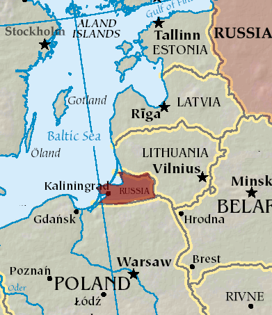
    A plane carrying the European Commission President Ursula von der Leyen was targeted by GPS jamming while attempting to land at Plovdiv International Airport in Bulgaria on Aug. 31, according to a European Commission spokesperson.

    Bulgarian authorities suspect Russia was responsible for the interference, European Commission Deputy Chief Spokesperson Arianna Podestà told CNN.

    The Kremlin has denied the allegation. Spokesperson Dmitry Peskov told The Financial Times, which first reported the story, that the information was incorrect.

    The plane landed safely despite the GPS disruption, with pilots reportedly using paper maps to navigate, according to a source familiar with the situation.

    Von der Leyen was traveling as part of a seven-country tour of the European Union’s frontline states to rally support for Ukraine. The incident occurred as her charter flight approached the southern Bulgarian airport during her diplomatic mission to reinforce the bloc’s commitment to defending against Russian aggression.

    Podestà told CNN that the incident highlighted the urgency of von der Leyen’s current trip to frontline member states, where she has witnessed daily threats from Russia and its proxies. The spokesperson noted it remained unclear whether attackers specifically targeted the flight or if it was caught in broader GPS interference operations.

    Expert Insights: Searching for Resilience

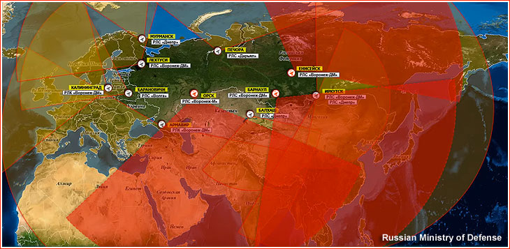
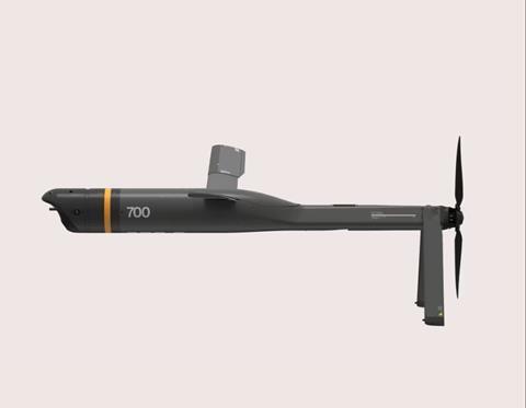
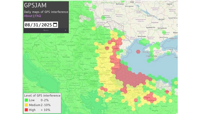
    This latest incident comes amid a dramatic surge in GPS jamming and spoofing attacks across the region since Russia’s invasion of Ukraine, creating an increasingly challenging environment for critical navigation systems.

    European Commission President Ursula von der Leyen’s current tour through Poland, Bulgaria, Finland, Estonia, Lithuania, Latvia and Romania takes her directly through many of the continent’s GPS disruption hot spots. These nations have experienced some of the most severe interference with GNSS, making the timing of her defense-focused diplomatic mission particularly significant.

    According to GPS World Editorial Advisory Board Member Mitch Narins, the current crisis represents the culmination of concerns that have been raised for more than twenty years. “Concerns and warnings regarding interference to GNSS have been raised for over two decades,” Narins explains. “Despite these concerns, attempts to install and upgrade alternative or complementary PNT systems on the ground and in aircraft have failed and resulted solely in increased investment in satellites and their signals, all of which are extremely low-power by design and vulnerable to interference.”

    “Regrettably, the substantial financial resources required to fund these satellite projects have pushed for discontinuance of resilient ground-based alternatives and to consider them ‘cost offsets,’” he notes. The economic incentives have favored satellite constellation expansion over diversification, despite the vulnerabilities of space-based systems.

    When it comes to alternative options, Narins explains, “For the cost of building and launching a single GNSS medium-Earth orbit (MEO) satellite, one could fund the replacement or installation and operation of many resilient ground-based systems for many years.”

    The current approach to PNT systems represents a departure from fundamental systems engineering principles, according to Narins. “When initiating a customer need analysis, a systems engineer does not begin with the solution and work backwards,” he emphasizes.

    Instead, the focus should be on meeting actual requirements: PNT systems must “always” provide the accuracy, availability, integrity and continuity of services necessary to support safety, security and economic well-being across thousands of use cases spanning every critical infrastructure sector.

    “Therefore, resilience must be a critical part of a PNT system’s performance if it is to be considered a potential solution,” Narins said. Rather than pursuing interoperability between GNSS constellations — which still leaves users dependent on inherently weak satellite signals — the industry should have prioritized diverse solutions from the outset.

    He added, “This is not a simple problem with a single, simple solution, but it is time to start thinking about resilience first and leaving the identification of solutions to a proper system engineering process.”

    New Ways to Counter EW Threats

    The dangerous GPS jamming of the plane carrying carrying European Commission President Ursula von der Leyen can be alleviated with advanced technology, according to Michael Biercuk, CEO of Q-CTRL, developers of quantum-based navigation systems:

    “The incident regarding the European Commission President’s plane has raised GPS denial from inconvenience to a strategic security threat. This is why we’ve focused our quantum tech development efforts on building resilient quantum navigation systems truly immune to jamming and spoofing. This technology is not science fiction – it has been validated in flight to outperform the best existing GPS backups by up to 100X. Through our partnerships with Airbus, Lockheed Martin, and others we’re ready to help build resilience for European transport, defense and commerce.”

    Chris Shaw, CEO and co-founder of Advanced Navigation also spoke on the incident, commenting “The answers to the GPS crisis are already here,” said Chris Shaw, CEO and co-founder of Advanced Navigation, which specializes in anti-electronic warfare navigation technology. “The problem isn’t innovation, it’s stagnation. GPS alone can no longer be treated as a reliable source of truth. What’s needed is a resilient architecture — inertial-centered and fused with multiple sensors — that keeps systems operating even when signals are denied or manipulated.

    “The reality is that adversaries are moving at the speed of code, while government procurement still runs at the speed of bureaucracy. That gap is a national security risk. Unless governments adopt a new model of rapid integration and real-time collaboration with industry, they will continue to be outpaced.

    “This isn’t optional. Survivability in GPS-contested environments depends on prompt deployment of inertial navigation. The companies pushing this forward aren’t just keeping up, they’re rewriting the playbook — and the cost of delay is measured in mission failure and compromised sovereignty.

    “Ukraine has shown what’s possible. By demanding real-time software updates and rapid hardware upgrades in close collaboration with industry, its forces are reshaping autonomy, navigation, drone swarms and integrated defense systems at an unprecedented pace — allowing them to outpace adversaries.

    “So why aren’t we applying this model more broadly beyond the battlefield? The solutions exist, with inertial navigation at the core. The real question is whether we’ll act before the cost of delay becomes irreversible.”

    The GPS Collapse isn’t fiction — it’s a warning of what happens when action is delayed.

  • Russian electronic warfare base linked to GPS jamming across Baltic region

    Russian electronic warfare base linked to GPS jamming across Baltic region

    The Estonian news portal Delfi reports that a covert Russian military installation in the Królewiec region, just east of Poland’s border, is believed to be responsible for GPS interference affecting the Baltic states and the Gulf of Finland.

    According to confidential sources, the facility’s primary mission is to monitor satellites and NATO communications, with the goal of undermining allied intelligence operations. Documents obtained by Delfi indicate that the base, located in Pioniersk, is part of Russia’s “Tobol” electronic warfare network.

    The Tobol system is described as a network of surveillance, defense and command sites designed both to shield Russian satellite communications and navigation systems from NATO attacks and to disrupt NATO intelligence. The Królewiec facility, which focuses on satellite monitoring, was officially established in 2009 by the Russian Ministry of Defence. Similar installations are located across Russia, including near Moscow, Penza, Cheboksary and in Ulan-Ude, Siberia.

    In July, Estonian authorities detected new jamming equipment near the eastern border by Narva and along the Narew Gulf coast. Experts believe these measures are intended to protect Russian facilities from potential Ukrainian drone strikes.

    The Finnish newspaper Ilta-Sanomat, reports that Russia has been developing navigation jamming technology since the 1980s, initially as a counter to GPS-guided weapons. Those capabilities have since expanded in response to Western military equipment supplied to Ukraine.

    Since the start of Russia’s full-scale invasion of Ukraine in 2022, incidents of GPS interference have increased in countries bordering Russia. Aviation and maritime navigation have been particularly affected, with pilots and ship crews reporting inaccurate or lost positioning data.