Tag: Russia

  • Russian SBAS Satellite on the Move

    News courtesy of CANSPACE Listserv.

    According to tracking information supplied by NORAD/JSpOC, spacecraft controllers have adjusted the orbit of the Luch-5A relay satellite. Luch-5A is the first of a set of three geostationary satellites being launched to reactivate Roscosmos's Luch Multifunctional Space Relay System. The system will be used to relay communications and telemetry between low-Earth-orbiting spacecraft, such as the Russian segment of International Space Station, and Russian ground facilities.

    The satellites also carry transponders for the System for Differential Correction and Monitoring (SDCM), Russia's satellite-based augmentation system. The transponders will broadcast GNSS corrections on the standard GPS L1 frequency using C/A PRN codes assigned by DoD's Global Positioning Systems Directorate. Luch-5A was assigned PRN 125; Luch-5B, PRN 140; and Luch-5V (previously called Luch-4), PRN 141.

    Luch-5A was launched on 11 December 2011 and was placed in a temporary geostationary orbit with a sub-satellite longitude of about 58.5 degrees east. The previously announced operational location for the satellite is 16 degrees west longitude.

    The satellite's orbit was lowered on or about 30 May and the satellite is now drifting slowly eastwards at a rate of about 1.6 degrees per day. At this rate, the satellite will reach 16 degrees west by November. Today, the sub-satellite longitude is about 81.5 degrees east.

    If the intended destination is actually 16 degrees west, it is not known why the spacecraft operators didn't arrange for the satellite to move westwards so that it would reach the destination in a shorter time. One thought is that to achieve such a move, the satellite's orbit would need to be raised and that could have put it into the graveyard region where defunct geostationary satellites are put to rest and where the chance of a collision might be higher. On the other hand, perhaps the satellite is being moved to another temporary location.

    Luch-5B is scheduled for launch on August 30, 2012.

  • Siberian City Sees Rebirth from GLONASS

    The Siberian city Zheleznogorsk, a hub of Russian space and nuclear technology, fell on hard times in the 1990s. Now, GLONASS has infused a new life and vitality into this once-secret city, as described in a feature by Russia and India Reports.

    The feature discusses the city’s history as attracting young scientists and specialists in the 1950s and 1960s, then its stagnation in the 1990s until its rebirth today, as a hub for GLONASS production. About 40 satellites are in production at the same time, including secret military systems, GLONASS satellites, and telecommunications and geodesy satellites for Russian operators.

    Read more at Glonass Revives Siberian Space Hub.

  • Russia to Increase Number of Space Service Centers to 25

    The number of Russian centers providing services based on data received via GLONASS satellites will reach 25, Deputy Prime Minister Vladislav Surkov said  Tuesday, according to a RIA Novosti report. The space service centers are engaged in satellite monitoring of traffic safety, road planning and cargo transportation on federal highways as well as natural dangers such as landslides, avalanches, and mud flows.

    “Ten space service centers have already been established in Russia, the establishment of another 15 is planned,” Surkov said at a satellite navigation forum in Moscow. So far, there are centers in Moscow, Sochi, Kazan, Kaluga, Ryazan and five more Russian cities.

    Russia has 31 GLONASS satellites in orbit, with 24 operating to provide global coverage, four in reserve, two under maintenance, and one undergoing trials. According to Russia’s space agency Roscosmos, two Glonass satellites are under maintenance, one is on standby, and one recently launched satellite is being integrated into the grouping. The complete Glonass grouping needs 24 functioning and 2-3 reserve satellites to operate with global coverage.

  • GLONASS Modernization

    By Yuri Urlichich, Valery Subbotin, Grigory Stupak, Vyacheslav Dvorkin, Alexander Povalyaev, Sergey Karutin, and Rudolf Bakitko, Russian Space Systems

    The GLONASS-K satellite, transmitting a CDMA signal in the L3 band, inaugurates a new era of radionavigation signals for both the Russian system and for international GNSS interoperability. As demand for high-precision services through dual- or triple-frequency user equipment increases, GLONASS will come to the forefront. The 2014 GLONASS-K2 satellite will have an FDMA signal in the L1 and L2 bands and CDMA signals in L1, L2, and L3. The overall constellation update will be completed in 2021. Another 2014 launch will fill the Russian SBAS orbit constellation with three geostationary space vehicles.
    Glonass-M-W
    GLONASS-M satellite. (Photos courtesy of Roscosmos and Information Satellite Systems Reshetnev Company)
    Glonass-K-W
    GLONASS-K satellite. (Photos courtesy of Roscosmos and Information Satellite Systems Reshetnev Company).

    With the February launch of the first GLONASS-K satellite, and its transmission of a new CDMA signal in the L3 band, a new era of radionavigation signals has begun: international GNSS interoperability. As we have seen rapidly growing demand for high-precision services provided with dual- or triple-frequency user equipment, introduction of new GLONASS signals in the L1 and L2 bands will come next. The first launch of GLONASS-K2 satellite, with FDMA signals in L1 and L2 bands and CDMA signals in L1, L2, and L3, is planned in 2014. A complete update of the full orbiting constellation will conclude in 2021.

    One satellite per year of the Luch family will be launched into orbit over the next three years, and by 2014 the System of Differential Correction and Monitoring (SDCM) constellation will be in operation with three geostationary space vehicles.

    Constellation Status. In spite of the unsuccessful launch of three satellites at the end of 2010, currently GLONASS is fully deployed again with 23 satellites set healthy to the user, and more in orbiting reserve. Figure 1 shows the evolution of the constellation since its first launch in 1982. The number of satellites used for service provision is calculated at the end of each year. In order to avoid dramatic situation in 1996–2000, when satellite numbers fell, the system now carries both an on-orbit and a ground reserve of space vehciles. This will help avoid service and availability gaps that could be created by satellite failure.

    Karutin-1-W Source: Yuri Urlichich, Valery Subbotin, Grigory Stupak, Vyacheslav Dvorkin, Alexander Povalyaev, Sergey Karutin, and Rudolf Bakitko, Russian Space Systems
    Figure 1. GLONASS constellation development.

    GLONASS-M. The current constellation consists largely of GLONASS-M satellites, the first generation of GLONASS space vehicles, with characteristics of:

    • FDMA сivil signals in L1 (1.6 GHz) and L2 (1.25 GHz) bands, with increased transmitting power;
    • intersatellite link both inside one plane and between planes with ranging and communication capabilities;
    • relative daily frequency stability of the cesium onboard synchronizer of 5 × 10–14;
    • increased orientation accuracy of solar panels;
    • guaranteed active lifetime of seven years.

    New satellites can be launched into orbit either as a part of multiple launch consisting of three satellites on the launch vehicle Proton with booster Breeze-M from the Baikonur spaceport, or on the launch vehicle Soyuz with Fregat booster from Plesetsk.

    GLONASS-M is the last GLONASS satellite with its payload in a sealed container. This container provides the high-temperature stability for the onboard clocks. The GLONASS-M power-supply system includes nickel-hydrogen batteries and silicon solar arrays of 30 square meters, providing 1,400 W for onboard systems.

    GLONASS-K. Currently, on-orbit flight tests of the new GLONASS-K satellite (OPENING PHOTO) are under way. The first satellite in the GLONASS-K family, it has a payload located in open space and an active lifespan of 10 years. The forming and transmitting functions of navigation and inter-satellite signals are united in one module in order to increase synchronization accuracy. Besides broadcasting radionavigation signals in three bands, this satellite carries the transponder of the search-and-rescue system COSPAS-SARSAT. The overall weight of the satellite is less than 1,000 kilograms, and about 30 percent of this is the payload weight. The power-supply system generates about two times more energy than the same GLONASS-M system.

    At the same time, ground-control facilities modernization and implementation of new inter-satellite measurement technology has enabled system operators to effectively increase the accuracy of broadcast ephemeris and clocks. Currently the signal-in-space range error (SISRE) equals 1.37 m (Figure 2). Further increases in accuracy will be carried out through the modernization of satellite-control technologies and development of a global network of measuring tools.

     Figure 2. GLONASS signal-in-space range-error improvement. Source: Yuri Urlichich, Valery Subbotin, Grigory Stupak, Vyacheslav Dvorkin, Alexander Povalyaev, Sergey Karutin, and Rudolf Bakitko, Russian Space Systems
    Figure 2. GLONASS signal-in-space range-error improvement.

    Navigation Signals

    Since February 2011, GLONASS-K has been transmitting the first CDMA navigation signal in L3 band coherently with existing L1 and L2 signals. This was a first step in a new navigation signal development strategy. Future steps of GLONASS CDMA navigation signal development will focus on L1 and L2 bands. In order to design user-friendly signals, the following assumptions have been taken into account:

    • GLONASS coherent FDMA and CDMA navigation signal sets should satisfy a wide range of user requirements, from ordinary navigation to high-precision applications;
    • Signals should be within the bands allocated for GLONASS by the International Telecommunications Union (ITU);
    • Low spectral density of signal power in radio astronomical band of 1610.6-1613.8 MHz;
    • Compatibility with other GNSSs;
    • Interoperability with other GNSSs.

    The plans for signal development with GLONASS code division are presented in Table 1.

     Table 1. FDMA (in bold type) and CDMA (in slant type) signals in current and future GLONASS satellite generations. Source: Yuri Urlichich, Valery Subbotin, Grigory Stupak, Vyacheslav Dvorkin, Alexander Povalyaev, Sergey Karutin, and Rudolf Bakitko, Russian Space Systems
    Table 1. FDMA (in bold type) and CDMA (in slant type) signals in current and future GLONASS satellite generations.

    Figures 3–8 show the proposed structures of GLONASS CDMA signals and also the spectrums of these signals in the context of the other GNSS signal spectrums.

     Figure 3. GLONASS L1 CDMA signal. Source: Yuri Urlichich, Valery Subbotin, Grigory Stupak, Vyacheslav Dvorkin, Alexander Povalyaev, Sergey Karutin, and Rudolf Bakitko, Russian Space Systems
    Figure 3. GLONASS L1 CDMA signal.
     Figure 4. GLONASS L2 CDMA signal. Source: Yuri Urlichich, Valery Subbotin, Grigory Stupak, Vyacheslav Dvorkin, Alexander Povalyaev, Sergey Karutin, and Rudolf Bakitko, Russian Space Systems
    Figure 4. GLONASS L2 CDMA signal.
     Figure 5. GLONASS L3 CDMA signal. Source: Yuri Urlichich, Valery Subbotin, Grigory Stupak, Vyacheslav Dvorkin, Alexander Povalyaev, Sergey Karutin, and Rudolf Bakitko, Russian Space Systems
    Figure 5. GLONASS L3 CDMA signal.
     Figure 6. L1 band. Source: Yuri Urlichich, Valery Subbotin, Grigory Stupak, Vyacheslav Dvorkin, Alexander Povalyaev, Sergey Karutin, and Rudolf Bakitko, Russian Space Systems
    Figure 6. L1 band.
     Figure 7. L2 band. Source: Yuri Urlichich, Valery Subbotin, Grigory Stupak, Vyacheslav Dvorkin, Alexander Povalyaev, Sergey Karutin, and Rudolf Bakitko, Russian Space Systems
    Figure 7. L2 band.
     Figure 8. L3 band. Source: Yuri Urlichich, Valery Subbotin, Grigory Stupak, Vyacheslav Dvorkin, Alexander Povalyaev, Sergey Karutin, and Rudolf Bakitko, Russian Space Systems
    Figure 8. L3 band.

    Due to the growing use of GNSS signals in L3/L5 band, the future GLONASS navigation family will include two signals in this band. Table 2 contains some parameters of these new signals in this band.

    Table 2. Table: Yuri Urlichich, Valery Subbotin, Grigory Stupak, Vyacheslav Dvorkin, Alexander Povalyaev, Sergey Karutin, and Rudolf Bakitko, Russian Space Systems
    Table 2.

    GLONASS Augmentation Development

    SDCM development is now entering its deployment and completion phase. The network of reference stations is almost completely established. It enables the global integrity monitoring of radio navigation signals of both GLONASS and GPS satellites, gathering raw measurements of pseudorange and carrier phase in L1, L2, and L3/L5 bands. Based on these measurements, the SDCM central processing facility calculates orbits and clock corrections, and formulates SBAS messages. Preliminary results of SDCM service-quality estimation, based on corrections calculated using existing stations network, are shown in Figure 10.

     Figure 10. SDCM horizontal protection Level (HPL) versus horizontal alert limit (HAL). Image updated April 16, 2012. Source: Yuri Urlichich, Valery Subbotin, Grigory Stupak, Vyacheslav Dvorkin, Alexander Povalyaev, Sergey Karutin, and Rudolf Bakitko, Russian Space Systems
    Figure 10. SDCM horizontal protection Level (HPL) versus horizontal alert limit (HAL). Image updated April 16, 2012.

    The last quarter of 2011 will see the launch of space vehicle (SV) Luch-5А, carrying an SDCM transponder. Initially, this SV will be put for testing on geostationary orbit at 55 degrees East, and then will be relocated to 16 degrees West. The onboard transponder will broadcast radio signals on 1575.42 MHz. Taking into account that the main SDCM coverage area is in the northern hemisphere, the SV antenna beam will be deviated from the Equator by 7 degrees to the north.

    Due to this deviation of the gain pattern from traditional orientation to the Equator, the Earth surface power distribution diagram is changed. Figure 11 presents two variants. The first one is a case in which the transmission antenna is directed on the Equator (curve 1) and the second one is a case when antenna is deviated by 7 degrees to the north from equator (curve 2). In the latter case, we obtain an increase of signal strength to the users for which this SV is under small elevation angles, that is, for the users in the northern areas of the Russian Federation.

    Kartin-figure10 Source: Yuri Urlichich, Valery Subbotin, Grigory Stupak, Vyacheslav Dvorkin, Alexander Povalyaev, Sergey Karutin, and Rudolf Bakitko, Russian Space Systems
    Figure 11. SDCM minimum user-received signal levels: (1) antenna pointing to the equator; (2) antenna deviated by 7º to the north.

    Further SDCM development is predicated upon the launch of two Luch satellites, in the first half of 2012 and in 2013, respectively. Also in the plans is the design of a new Luch-4 satellite with dual-frequency navigation transponder, for a 2014 launch, completing the satellite-based augmentation system.

    Conclusion

    GLONASS system replenishment has almost finished, and the system enters a new historical phase. New CDMA navigation signals and deployment of a national SBAS system will provide not only a significant quality improvement of GLONASS navigation services, but also will create the favorable prerequisite for the development of applied navigation technologies in the territory of the Russian Federation, and also in Europe, the Middle East, and the Far East.


    Yuri Urlichich is a general director-general designer of Joint Stock Company (JSC) Russian Space Systems, GLONASS general designer, doctor of science, professor, author of more than 150 papers and holder of 20 patents.

    Valery Subbotin is a first deputy general director–general designer of JSC Russian Space Systems, and doctor of science. He has been working in the space industry for more than 40 years and has published more than 50 papers.GRigory Stupak is a deputy general director–general designer of JSC Russian Space Systems, deputy general designer of GLONASS, and professor at the Bauman Moscow State Technical University (BMSTU). He has worked in the space industry more than 35 years and has published more than 150 papers.

    Vyacheslav Dvorkin is a deputy general designer of JSC Russian Space Systems”and doctor of science. He has been developing GLONASS, GNSS augmentations and user equipment for more than 35 years. He has written 50 papers in the satellite navigation field.

    Alexander Povalyaev is a deputy head of division in JSC Russian Space Systems and professor at the Moscow Aviation Institute. He has been developing methods and algorithms for GNSS carrier-phase measurements processing for more than 30 years and has more than 40 papers in satellite navigation field.

    Sergey Karutin is deputy head of division in JSC Russian Space Systems and assistant professor at the BMSTU. He has a Ph.D. and has been working on the GLONASS team since 1998, developing GNSS augmentations and user equipment.

    Rudolf BAKITKO is a department head in JSC Russian Space Systems and a GLONASS navigation payload designer. Rudolf developed on-board equipment for space vehicles Luna, Mars, Venus, GLONASS, and COSPAS-SARSAT, and has more than 50 papers and 10 patents.

  • How GPS and GLONASS got together — and other recent events

    The recent broadcast of the first CDMA signal from the new GLONASS-K satellite culminates a long series of events that began in 1989. A key participant gives a first-hand account of the history of many meetings, formal and informal, that created true interoperability between the two major satellite systems, giving users a modern GNSS in action.

    October 18, 1989, the Queen Elizabeth Auditorium in London, around 8:30 am. Unknown to me, two 60-minute periods were about to imprint themselves indelibly on my memory.

    I walked up the stairs to the exhibition booth of my company, Ashtech, at The Royal Institute of Navigation conference. My good friend, the late Ann Beatty, met me and asked, “Any news from home?”

    I thought it was just a casual customary question, and replied: “Thanks, all OK.” She had a strange look on her face. She continued: “Are all your family really OK?” I replied again: “Thanks, all good.” She then realized that I had no clue about the cataclysmic event that had hit the San Francisco Bay area. She abruptly said, “Don’t you know? The big one came! The big earthquake hit San Francisco!”

    Californians know the rumors that when The Big One comes, Nevada will have ocean frontage. Now she was telling me that The Big One came! I rushed to the phone, and the recorded AT&T message said, “All lines to your area are out of service.” It took me another hour to find out that this was not yet The Big One, and that my family was safe. I will never forget these 60 minutes of my life. Never!

    Nor will I ever forget the events of the next 60 minutes.

    After the stress had settled a bit, a delegation from the Russian Space Agency visited our booth. First they expressed their sympathy regarding the earthquake. Then we discussed GPS technology and its similarities with GLONASS. Both systems were fairly new then, although GPS had started first, with a Block I launch in 1978, followed by GLONASS with a launch in 1982. At the time we met in London, GPS was flying 12 satellites, and GLONASS also had 12 in orbit.

    The Russian delegation visited all GPS manufacturers’ booths in the exhibition hall and then gathered in the coffee area for their private discussions. A few hours before the conference closed, they returned to our booth and said, “We want to combine GPS and GLONASS, and you are our first choice.” Simply put, I was fascinated and excited.

    After working out visa and travel details, four months later I arrived in Moscow in the cold days of February 1990. It was still the Soviet Union.

    I had grown up in Iran where the U.S.S.R. was our neighbor to the north. Remembering the global political landscape of my childhood days, I felt both fascination and fear as my airplane landed at Moscow airport.

    Upon meeting the people who greeted me at the airport, my fears disappeared, and my fascination grew stronger.

    Our first formal meeting took place in the Institute of Space Device Engineering (ISDE), a division of the Russian Space Agency that was responsible for the GLONASS program. The opening photo shows me with the late Dr. Nikolay Yemelianovich Ivanov, director of the GLONASS program, at that first meeting.

    I want to focus a bit on the GLONASS team and applaud them for their efforts. What makes the GLONASS team special is that they worked under much harder political and financial conditions than the GPS or Galileo teams. But still they were able to make the project successful. The Soviet Union and later Russia went through huge political, economic, social, and geographical revolutions, but the GLONASS team managed to keep the satellite navigation program alive and successful.

    Galileo’s management, while enjoying much more stability and financial luxury, can certainly appreciate and understand the significance of what the GLONASS team accomplished. Galileo also benefitted from the European integration of 27 countries, while the Soviet Union disintegrated into 15 separate nations.

    Despite all their heroic work, individuals on the GLONASS team have received almost no international recognition. At home they went unnoticed, due to their political situations. For example, the highest international recognition that Dr. Ivanov received was that he became a member of the GPS World Advisory Board, which I facilitated. In this article, I want to salute some members that I know and at least keep their names and photos recorded in the GPS World archives.

    In the first meeting, everyone recognized and emphasized the great potential of combining GPS and GLONASS for a variety of applications. I became more assured of the deep desires of my hosts to make this happen. They had prepared detailed charts and plans, especially for high-precision applications. They also gave me the GLONASS Interface Control Document (ICD) for the first time.

    We signed a cooperation protocol and agreed to explore technical details in our next meeting, which occurred a few months later. There I began to know Dr. Stanislav “Stas” Ulianovich Sila-Navitsky, at that time the chief scientist of Dr. Ivanov’s team. Later he became my vice president in three companies that I founded. He also became my best friend of 19 years, before he passed away on May 7, 2010.

    We had several meetings in Moscow and one in Paris in the headquarters of our partner SAGEM.

    I have wonderful memories of all the meetings. One meeting in Paris included General Leonid Ivanovich Gusev, the head of ISDE. One evening Stas called my hotel room and asked me to cancel our dinner at a famous French restaurant and instead join them for a “real dinner.” Apparently General Gusev was tired of French food! The real dinner took place in the General’s hotel room, and the menu consisted of dark Russian bread, Russian kielbasa sausage, Russian seledka herring, and an abundance of Russian vodka.

    Our first announcement of combining GPS and GLONASS was published in GPS World magazine, in only its second issue, March/April 1990. That year we had a poster banner in our Institute of Navigation exhibition, showing the American flag and the Soviet flag (hammer and sickle) next to each other. My very good friend, Colonel Gaylord Green, the second director of the GPS Joint Program Office, refused to have his picture taken with me in front of that banner. Instead, we stood over to another side of the booth for his photo.

    A few months after the Paris meeting, the political process known as perestroika began and caused the Soviet Union to end. Life became extremely difficult for Russians.

    I called Stas to discuss the situation. We concluded that we had no choice but to continue the plan on our own if we wanted to combine GPS and GLONASS. I went back to Moscow several times, and in February 1992 officially opened the Moscow office of Ashtech. This office is still operational in Moscow with about 10 percent of the original team. It is now in the process of being purchased by Trimble Navigation. What a turn of events!

    In 1996 we introduced the first combined GPS and GLONASS receiver; the product announcement appeared in GPS World, July 1996

    Back home in the United States, the situation was different. Supporting GLONASS was an unpatriotic act. The most prominent figures of GPS teased me for wasting my time with GLONASS. The news favored their arguments: the Russian economy was going downhill. In September 1998, the Russian ruble collapsed more than 300 percent within a week. Banks closed. Even Coca Cola was not able to pay its employees in Russia because of bank closures. Many western companies left Russia. During that period, I intentionally stayed longer times in Moscow and managed to pay our employees without a day of delay. Furthermore, a more than three-fold rate change in favor of the dollar made our employees relatively rich, because their salaries were based on the U.S. dollar.

    I remained confident that GLONASS would succeed because I had seen the enthusiasm and dedication of GLONASS management and engineers.

    My Ashtech partners wanted to take the company public to recoup their investments. They thought Wall Street would negatively view GLONASS and the Russian connection. So my aspiration did not match theirs, and I started Javad Positioning System (JPS) in 1996. About 90 percent of the staff engineers followed me to JPS.

    One of John Scully’s vice presidents did to Ashtech what Scully did to Apple. Meanwhile JPS became very successful, as Apple did when Steve Jobs returned.

    Subsequent to another event and termination of some obligations and commitments, I started JAVAD GNSS in June 2007. Almost all of the key people followed me again. Our current team has a history of working together for close to 20 years.

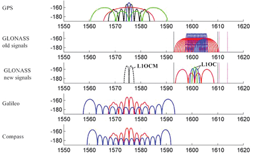
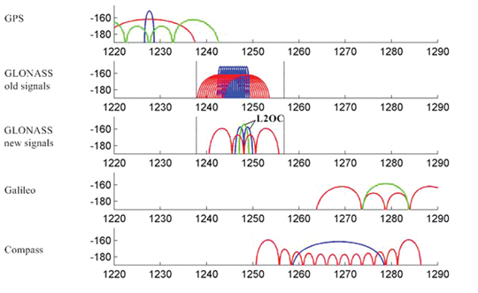
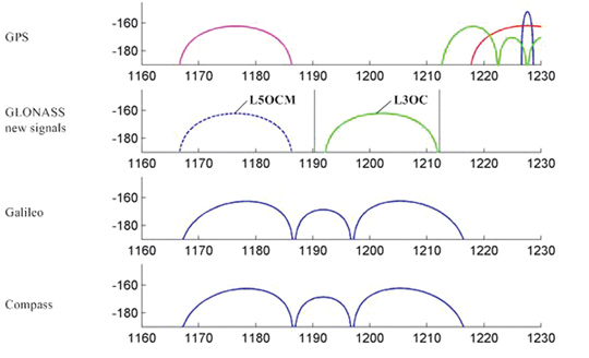
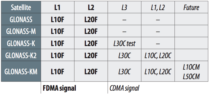
    In JAVAD GNSS we raised the bar of GPS/GLONASS integration to a higher level and focused in two new directions. The first was to eliminate the problem of GLONASS inter-channel biases, which is inherent to the GLONASS frequency-division multiple access (FDMA) signal structure. The second was to support the opinion of GLONASS engineers who were pushing for a new code-division multiple access (CDMA) signal for GLONASS, similar to the GPS signal.

    We resolved the GLONASS inter-channel biases issue around 2009 and announced, “Our GLONASS is as good as GPS.”

    On the second front, we worked with the top managements of ISDE and the Information Analysis Center (IAC) of the Russian Space Center to demonstrate the advantages of CDMA for high-precision applications.

    Some years ago, Stas had confided in me that the issue of CDMA was nothing new, and had been extensively deliberated at all levels of various GLONASS organizations during the early design phase of the system. The result of all these discussions was that engineers and technical people favored CDMA, but the higher management, mostly influenced by the military organizations, held out for FDMA. The reason for favoring FDMA is still a secret, though some believe that they just wanted to be different from GPS and did not see much advantage in CDMA. Some also believed FDMA gave better jamming protection.

    Of course in those very early days, no one imagined using GPS or GLONASS for high-precision applications, and as such truly there was not much difference between CDMA and FDMA. Much later, the notion of using carrier phase of GPS and GLONASS signals for high-precision applications was discovered, and then the advantages of CDMA became relevant, as Dr. Ivanov also hinted in our first meeting.

    After we combined GPS and GLONASS, and as a lot of our worldwide users began comparing the two systems, the issue of CDMA versus FDMA again came up for discussion among the GLONASS authorities.

    More recently, since 2007, we had several meetings in the offices of ISDE in Moscow, in IAC in Korolev (the Russian Space City), and several in our JAVAD GNSS office in Moscow. Most importantly, we had several meetings in my Moscow apartment, enhanced by Russian vodka and the best Armenian cognac, courtesy of Sergey Revnivykh, head of IAC. All meetings were open and candid, discussing and demonstrating the advantages of CDMA, in support of the ISDE engineers who were reluctant to express their opinion above certain levels.

    I also met with the head of the Russian Space Agency, Dr. Anatoly Nikolayevich Perminov, who personally supported and sponsored me in obtaining an extended Russian residency visa. Let me also express my appreciation for receiving the Medal of Honor from the Russian Cosmonauts Federation, along with the official astronaut watch. I don’t understand the reason for receiving a Kalashnikov AK-47 semi-automatic rifle from ISDE for my birthday. I wonder how I can transport it home!

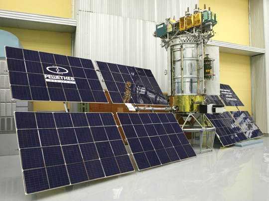
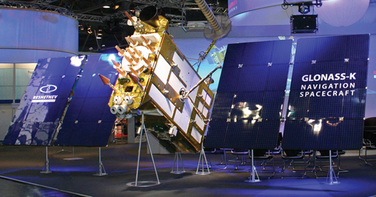
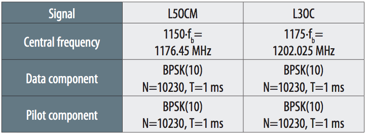
    General Anatoly Shilov (deputy director of the Russian Space Center), Dr. Vicheslav Dvorkin (GLONASS deputy general designer), Sergey Revnivykh, Viktor Kosenko (first deputy of chief GLONASS designer) and Sergey Karutin (GLONASS senior scientist) are the new generation of GLONASS leaders who deserve credit for supporting CDMA on GLONASS. Recently, a new GLONASS-K sat-ellite was launched, transmitting an experimental CDMA signal in addition to the legacy signals. Almost immediately, we announced tracking of the new GLONASS-K satellite and its new L3 signal details, hours after it started transmitting. See GPS World archives and our website for details of this signal which seems, in all aspects, as good as GPS.

    Another new issue of significant international concern was a new frequency for GLONASS. This issue was more political than technical, and is discussed under the umbrella of interoperability.

    In the early days of my frequent travels to Russia, the KGB probably suspected that I was a CIA agent — and the CIA probably suspected that I was a KGB agent! I would not be surprised if both the CIA and KGB monitored every bit of my travels and activities. After some years, the San Francisco airport authorities stopped interrogating me for my activities in Russia any time I came back home. Perhaps because of their deep investigations, I earned the trust and friendship of both sides, and their confidence that I had nothing in mind other than helping to integrate GPS and GLONASS. I was an unofficial member and friend of both U.S. and Russian delegations during the so-called interoperability discussions since 2007, which sometimes touched on the CDMA issue as well.

    Some of the most fruitful and friendly discussions between the U.S. and Russian delegations occurred in my apartment in Moscow, after their official meetings. Ken Hodgkins of U.S. State Department; Mike Shaw, director of the National Space-Based Positioning, Navigation, and Timing Coordination Office; David Turner, director of the Center for Space Policy & Strategy; Scott Feairheller of the U.S. Air Force; and Tom Stansell, consultant to the GPS Wing were some of my honored guests.

    The new GLONASS frequency discussions are still in progress, and I am proud to host and support both sides the best that I can. Sometimes it is fun to observe that discussions resemble poker games where hands are known to all sides, but players still try to bluff each other! Let’s leave it at that for now.

    In May of this year, I had a conversation with General Anatoly Shilov, now second-in-command of the Russian Space Agency, reporting to the first deputy of the minister of defense, General Vladimir Popovkin, who recently replaced Dr. Perminov as head of the Russian Space Center. This is an indication of increased attention and support from the Russian government to its GLONASS program. In our conversation, General Shilov was enthusiastic and optimistic that the GLONASS program will move forward faster.

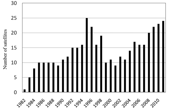
    GLONASS has proven to be a real and reliable complement to GPS. If it were not for the failure of the launch of three GLONASS satellites in December 2010, its constellation would be complete and fully, globally operational today. It will happen soon. Sergey Revnivykh estimates that currently the system has 99.8 percent global coverage.

    Today, a truly reliable and fast RTK is not possible without combining GPS and GLONASS satellites.

    The most recent testimony to the success of GLONASS comes from the long-time GLONASS opponents who once criticized me for supporting the system. Recently they had to pay a lot of money to acquire the first company that I founded in Moscow, which they believed would never survive.

    This year at JAVAD GNSS, I and most of my original employees and GLONASS designers are celebrating our 20th year in Russia, and we are working harder to make the integration of GPS and GLONASS even better.

    On May 7, 2010, Stas lost to leukemia. He was not present to witness the successful introduction of our TRIUMPH-VS receivers. My refrigerators in Moscow are full of medicines that he brought for me any time I had a little cold. I miss him a lot, and our team is dedicated to following the path that Stas loved so much.

    I want to briefly summarize the current status and the future of GPS and GLONASS from the users’ point of view.

    GLONASS now has 24 satellites transmitting FDMA signals in two frequency bands. The failure in the last launch to deploy three more satellites delayed completion of the constellation to the end of 2011. The good thing about GLONASS is that both of its L1 and L2 signals are not encrypted and give better data than GPS P1 and P2 that are encrypted.

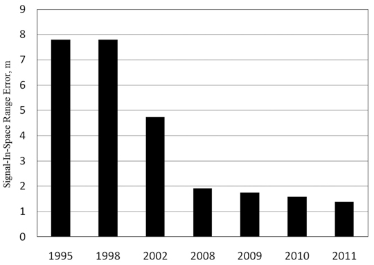
    GLONASS is considering a plan to add CDMA signals to all satellites and not suffer from inter-channel biases. But it will take about 10 years for this plan to become complete for public use, even if the plan is approved and followed. At JAVAD GNSS, we have already mitigated the effect of GLONASS inter-channel biases to the accuracy of better than 0.2 millimeters. We made GLONASS FDMA the same as GPS CDMA by adding some innovations (patent pending) and enhanced algorithms.

    The GPS plan is to add a third frequency signal (called L5) and add an unencrypted signal in L2. But it will take several years to have enough new satellites transmitting these new signals to make them usable for daily work.

    In the near term, we have two complete systems, consisting of about 30 GPS and 27 GLONASS satellites. The current non-encrypted GLONASS signals give it an edge over the current GPS encrypted signals, given the fact that we have mitigated the GLONASS FDMA inter-channel biases.

    GLONASS is also enhancing its control segment to better monitor GLONASS satellites and improve the system’s clock and orbit parameters. Most of these errors are cancelled in differential and high-precision applications anyway.

    Existence of two complete and free systems, GPS and GLONASS, will place some doubt on the future of Galileo, as it will be extremely difficult for Galileo to hope to collect money from users to fund itself. The addition of Galileo, as a third system, will not really add much benefit for users anyway. The only push for deploying Galileo must come from some European military organizations to support their specific interest.

    I have been extremely fortunate also to have had the opportunity to work on GPS from its early days, co-pioneering high-precision applications at Trimble Navigation. I owe a lot to Charlie Trimble, who helped me to lift myself up when I sought refuge in the United States in 1981. He taught me GPS as well as dedication in business. I also benefitted from Sunday meetings with Dr. Bradford Parkinson, the first program director of GPS, who was and still is a board member of Trimble Navigation. I am curious to find out how Brad, as a board member, voted in the recent matter of the purchase of Ashtech. Since leaving Trimble, my innovative products at Ashtech, JPS, and JAVAD GNSS have been well documented through the years in GPS World.

    My emphasis on GLONASS in this memoir is only to record some histories and recognize GLONASS and some of its pioneers who were often overlooked. GPS is already a well-known, well-established system and is the backbone of GNSS.

    As a final note, let me add that our current JAVAD GNSS products have the option of tracking all current and future signals of GPS, GLONASS, QZSS, and Galileo. Yes, Galileo too!

  • GLONASS K-1 Launch Delayed Twice, Rescheduled for Tomorrow


    GLONASS-K is moved to the launchpad.

    News courtesy of CANSPACE listserv.

    According to a Roscosmos report, the state commission governing rocket launches will launch GLONASS-K1 on February 26 at 03:06 UTC. The launch of GLONASS-K1 has been pushed back for “technical reasons.” The original schedule called for a February 24 launch.

    Quoting the commander of the Russian Space Forces, Lieutenant-General Oleg Ostapenko, an Interfax news item stated that there was insufficient time to ready the rocket for launch february 25, though it was announced as a launch date following the scrub on February 25. “The probability of a launch on the 26th is very high,” Ostapenko said.

    Meanwhile, Komsomolskaya Pravda quoted an unnamed space industry official as saying that if the launch is not held tomorrow, it will be put off for a month. “[The decision will be] once again to be safe, rather than to carry out the launch, which for technical reasons, was postponed for the second day in a row. Without further checks, and to eliminate technical problems, no one [wants to] take responsibility to conduct the launch,” he said.

    Gazeta.ru, an online Russian newspaper, has carried a report in which Nikolai Testoedov, the chief designer and CEO of Information Satellite Systems Reshetnev states that seven GLONASS satellites will be launched this year. In addition to GLONASS-K satellites being launched this month and in December, five GLONASS-M satellites will be launched. Three will be launched on a Proton-M rocket from Baikonur (this launch is expected in June). He said that, in addition, two GLONASS-M satellites will be launched on the Soyuz-2 rocket from Plesetsk. The first of the five GLONASS-M satellites is to be delivered to the customer on February 28.