Tag: Russia

  • Research Report: A Black Hole in Earth science

    Research Report: A Black Hole in Earth science

    Figure 1: Scientific observations with GNSS radio occultation (GNSS-RO), GNSS grazing-angle reflectometry (GNSS-GR) and GNSS reflectometry (GNSS-R) techniques from low-Earth orbit (LEO). (Figure provided by the author)
    Figure 1: Scientific observations with GNSS radio occultation (GNSS-RO), GNSS grazing-angle reflectometry (GNSS-GR) and GNSS reflectometry (GNSS-R) techniques from low-Earth orbit (LEO). (Figure provided by the author)

    Global navigation satellite systems (GNSS) for peaceful uses are facing a hard reality due to increasing regional conflicts in recent years. As a dual-use technology, GNSS for civil, commercial and scientific applications is vulnerable to both denied/degraded service and flex power operation from GNSS satellites and to jamming from the ground.

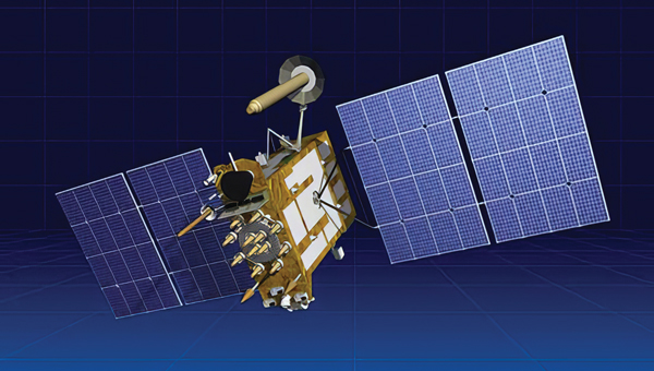
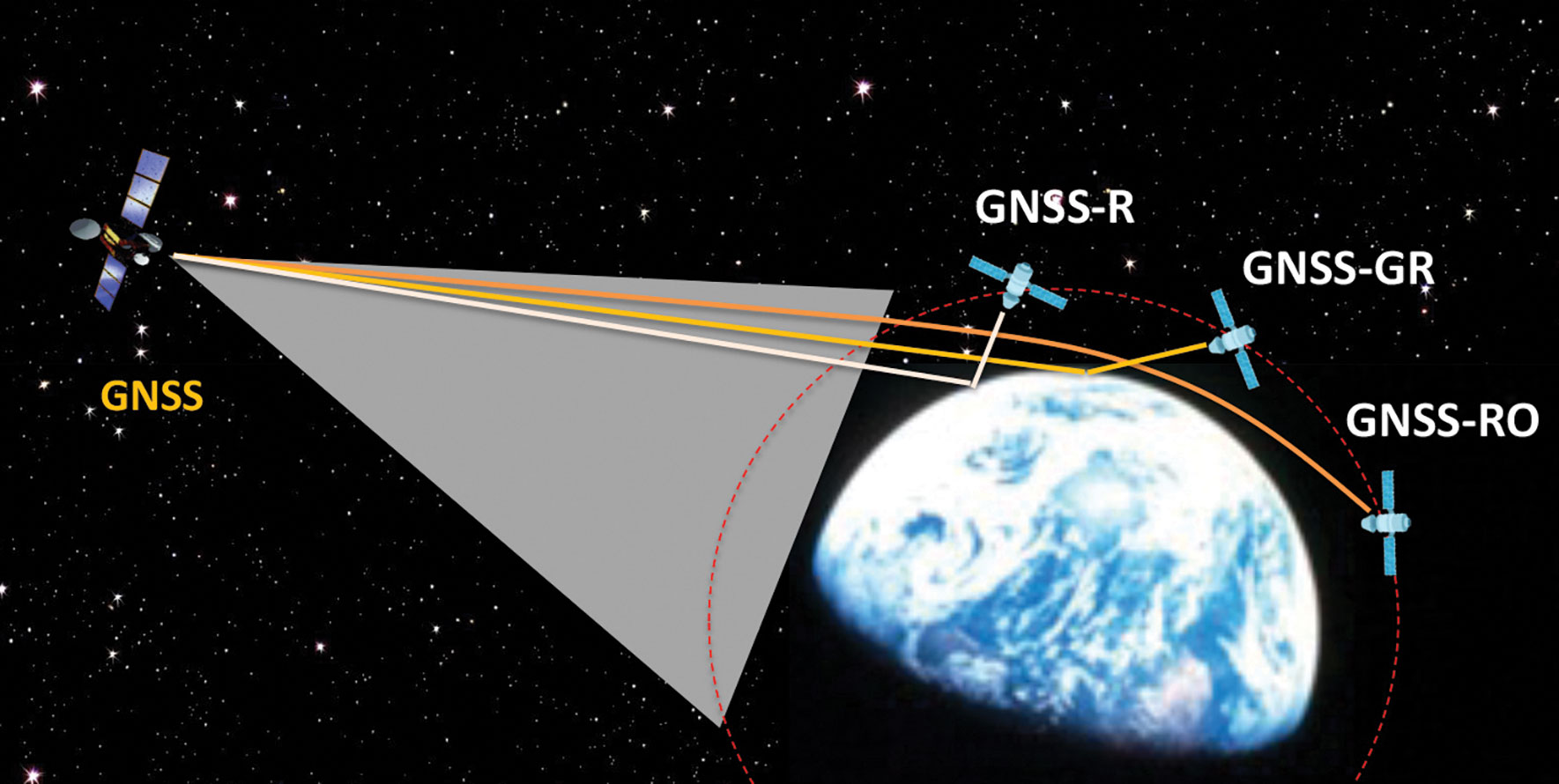
    One of the vulnerable scientific applications is the use of GNSS receivers on low-Earth orbit (LEO) satellites that utilize the civil navigation signals for Earth observation. These remote sensing techniques, such as GNSS radio occultation (GNSS-RO), GNSS grazing-angle reflectometry (GNSS-GR) and GNSS reflectometry (GNSS-R) (see figure 1), are designed to observe weak GNSS signals either bounced off from Earth’s surface or refracted by the atmosphere. Thus, GNSS flex power operation and intentional radio frequency interference (RFI) can severely degrade the quality of the scientific data or even prevent Earth observation.

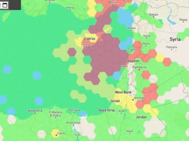
    One example of such impacts is a dramatic decrease of GNSS-RO observations over Europe and the Middle East during 2023. Monthly statistics from Spire show the region without GPS-RO measurements grew substantially from the localized Ukraine-Russia conflict zone in January to a much wider area in Eastern Europe and the Middle East in December 2023 (see figure 2).

    Figure 2: Number density distribution of monthly GNSS-RO measurements from the GPS tracking by the Spire constellation over Europe and the Middle East in 2023. The black area indicates no data. (Figure provided by the author)
    Figure 2: Number density distribution of monthly GNSS-RO measurements from the GPS tracking by the Spire constellation over Europe and the Middle East in 2023. The black area indicates no data. (Figure provided by the author)

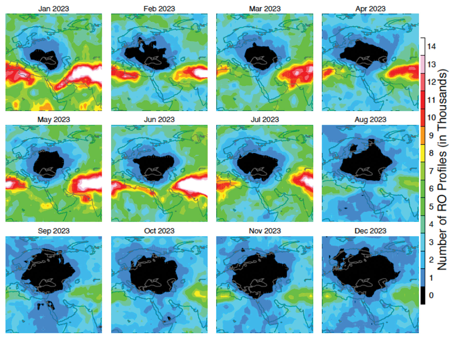
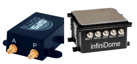
    This vast data void in the science observation is likely a result of the intensified electronic warfare used in Ukraine-Russia and the nearby conflict regions. The Spire RO receivers are configured to track the civil signals from GPS, GLONASS and Galileo. To increase signal protection against jamming in a conflict zone, GNSS service providers often use flex power operation. However, flex power operations can cause poor quality tracking with the RO receiver due to weaker signal power. Unlike a precise orbit determination (POD) antenna, the GNSS-RO antennas typically have a high gain to improve the detection of weak GNSS signals at limb and occulted views. However, if the transmitter power of civil signals drops below a quality-control (QC) threshold, the data are flagged as bad. This results in a poor coverage of Spire GNSS-RO in the conflict zones.

    Lost or degraded GNSS-RO, GNSS-R and GNSS-GR observations are unfortunate, as these all-weather sensing, long-term stability, and high-accuracy measurements are becoming increasingly important in scientific research. GNSS-RO is a remote sensing technique that uses the GNSS-LEO link to profile Earth’s atmosphere and ionosphere with high vertical resolution. Since the first GNSS-RO six-satellite constellation, known as Constellation Observing System for Meteorology, Ionosphere and Climate-1 (COSMIC-1), these high-quality RO profiles have become a key data source for weather forecasting, climate monitoring, model evaluation, and space weather research. The current backbone of GNSS-RO observations comes from the COSMIIC-2 and Spire constellations, which have been producing more than 20,000 profiles per day since 2020. GNSS-R is a bi-static radar technique that uses the GNSS signals reflected by the surface for altimetry, ocean surface wind speed, wave height sea ice, soil moisture, and inundation measurements. At a view angle between GNSS-RO and GNSS-R, GNSS-GR can provide complementary measurements for sea ice and atmospheric column water vapor. Because of low-cost LEO SmallSat/CubeSat constellations with the GNSS receivers, geoscience studies have benefited greatly from the sampling density and coverage of these new data.

    Civilization and science have been diverted by wars before. Despite the increased dependence on GNSS in recent years, their vulnerability to jamming and flex power operation poses a great challenge for scientific observations that need uniform global coverage.

  • Tough Times for Russian Navigation System

    Tough Times for Russian Navigation System

    The Russian satellite navigation system is experiencing tough times as Western sanctions and Russia’s ever-growing international isolation seriously complicate its further development.

    Prior to Feb. 24, 2022, when Russia invaded Ukraine, Russia’s navigation sector was developing well and had a healthy growth rate, which is reflected by the steady growth and improved performance of its satellite constellations. However, the start of Russia’s war with Ukraine and the consequent international sanctions regime against Russia has put an end to the hopes for further development of the sector and especially of its flagship GLONASS global navigation satellite system (GNSS).

    As for GLONASS, as academician Nikolai Testoedov, general designer of JSC Information Satellite Systems Reshetnev, one of Russia’s leading satellite manufacturing companies, said during a general meeting of the Russian Academy of Sciences, the main problem is that Western sanctions do not allow Russia to bring its positioning accuracy to the desired 30 cm or at least 50 cm.

    According to Testoedov, the main reasons for this are serious problems with the supplies of electronic components, most of which Russia traditionally imported. “Until 2014, when the first sanction restrictions were introduced, the share of imports in Russia’s entire satellite constellations reached 42%,” Testoedov said. “Currently we implement a strategy of import substitution in the sector, which is designed until 2030 and involves a transition to 100% domestic products. As of 2014, we had 6,000 electronic components of foreign origin. Since 2014, a lot of work has been done to combine various equipment. Now, it is used in Russia’s satellite constellations.”

    It has already brought some results. According to Ivan Revnivyh, head of the GLONASS department of the Russian space corporation Roscosmos, thanks to the new satellites that have been launched in recent years, the accuracy of GLONASS civil signals has increased up to 1.32 meters. According to Revnivyh, Russia plans to continue work in this direction as part of its existing federal project “Maintenance, development and use of the GLONASS system,” which intends to increase the accuracy of the signals up to 0.3 m.

    Russia plans to continue to improve GLONASS’s accuracy until it matches that of other GNSS and meets International Civil Aviation Organization (ICAO) requirements.

    “When landing a civil aircraft at unequipped airfields,” Testoedov said, “the signal should arrive with a delay of no more than 6 seconds, with an accuracy of no worse than half a meter.”

    Despite the sanctions, Russia plans to continue to develop GLONASS. As part of these plans, starting from 2025, it plans to launch modernized GLONASS-K2 satellites in an import-substituted and multifunctional version. Thanks to this, the signal will be 100 times more powerful than the standard one. That will be primarily achieved by using dedicated navigation satellites weighing about 1 ton.

    After 2030, Russia also plans to place six satellites in geosynchronous orbits (about 36,000 km), which will increase the availability of the signal in Russian cities and difficult terrains.

    There are also plans to create a constellation of 300 satellites in low-Earth-orbit (LEO) at an altitude of 500 to 100 km. They are expected to increase the strength Russian satellite signals by more than 1,000 times.

    In recent years, Russia has faced restrictive policies implemented by various international bodies, including the International Bureau of Weights and Measures and the International Association of Geodesy. According to Russian experts, many of these bodies are currently taking discriminatory measures against Russian systems and technologies.

    In this regard, Russia plans to propose to the countries members of BRICS — an intergovernmental organization comprising Brazil, Russia, India, China, South Africa, Egypt, Ethiopia, Iran and the United Arab Emirates — to design products and systems whose characteristics will be comparable to those of Western origin. According to Reshetnev Systems’ experts, however, this could improve results — mainly, accuracy — by only 20 percent, which would not be critical for Russia.

    GLONASS, which first achieved a full constellation of 24 satellites in 1995, currently consists of 24 satellites of three types: GLONASS-M, which has been produced since 2003, GLONASS-K which has been produced since 2011, and two GLONASS-K2, which Russia launched in 2023. All the satellites are part of the Cospas-Sarsat system.

    Despite the fact that the life expectancy for most Russian GLONASS satellites is seven to 10 years, many of them, according to Testoedov, are already more than twice as old. Russia plans to replace at least six GLONASS satellites within the next two to three years. In the first years of launching the constellation, Roscosmos usually launched nine satellites into orbit at once; currently, it is launching only one or two at a time.

    Still, it is possible that these rates will increase significantly, as by 2030 Russia plans to increase its constellation of satellites by up to 1,000 satellites. For this purpose, the country plans to produce 200-250 satellites per year.

    According to the head of Roscosmos, Yury Borisov, space industry enterprises should produce one satellite per day by 2030. According to him, the Russian Federation is ready to learn from the experience of other countries in this area, such as China.

  • Final grounding for Ingenuity?

    Final grounding for Ingenuity?

    NASA’s Ingenuity took this picture on Jan. 18, 2024. The sand-dune, rock-less area where Ingenuity last showing the shadow of its damaged rotor blade. (Image: NASA)
    NASA’s Ingenuity took this picture on Jan. 18, 2024. The sand-dune, rock-less area where Ingenuity last
    showing the shadow of its damaged rotor blade. (Image: NASA)

    It appears that the little extraterrestrial drone that could has come a cropper on Mars and now will not be flying again – it is permanently grounded. The Jet Propulsion Lab (JPL) crew managing Ingenuity was running a regular scouting trip over a featureless sand-dune area on Dec. 22, 2023. Suddenly, the UAV’s visual navigation system malfunctioned, which led to a hard emergency landing.

    When the autonomous navigation system did not have any landmarks to match its digital reference map, it reverted to an emergency landing. Maybe the poor guy should have had a few moments to gather its airborne wits and to come down softly, but alas at the same time the connection with the rover was lost, he dove for cover and broke a chunk off at least one of the counter-rotating blades. This now apparently prevents further take-offs. Mars’ atmosphere is only 1% as dense as Earth’s, so those rotors need all their designed lift capabilities to grab enough ‘air’ and get the 4 lb helicopter airborne. The flight control system may be unable to cope with the resulting compromised lift profile. Either way Ingenuity’s flying days are over, according to NASA.

    Conceptual design for the Sample Recovery Helicopters (Image: Aerovironment/ NASA/ JPL)
    Conceptual design for the Sample Recovery Helicopters
    (Image: Aerovironment/ NASA/ JPL)

    Ingenuity completed 72 flights over the course of three years, surpassing its original 30-day mission to prove the possibility of a miniature, autonomous helicopter flight on Mars. After its initial four flights, NASA and JPL chose the UAV to scout out safe paths for the Perseverance rover from an airborne perspective.

    All is not lost for Ingenuity, however. AeroVironment, the UAV manufacturer that co-developed Ingenuity with NASA/JPL, has been awarded another contract to design and develop two prototype ‘sample-return’ helicopters for NASA’s next major Mars expedition.

    Building on Ingenuity’s design, the new UAV will have wheels and a grappling contraption to pick up sample tubes, which could assist in the Mars sample recovery mission. Perseverance is currently expected to be the lead in transferring cached sample tubes to the new Sample Retrieval Lander for return to Earth, but the new helicopters provide a different backup option on Mars for pick-up and transport of the tubes.


    Back here on Earth, the latest tragic news from the Middle East — the UAV attack on the US Tower 22 military outpost in Jordan which cost three soldiers their lives and injured at least 34 others — appears to have been due to a lack of defensive capability. Earlier news releases indicated that the kamikaze UAV had arrived at the same time as the expected return of a U.S. UAV from the base, implying that defenses may have been taken down temporarily. It now seems that there was little active defense to prevent the attack.

    The attacking UAV reportedly came in very low, and the base was unable to track its approach. The base is said to have defensive signal jamming capabilities, but without radar visibility of the UAV and knowing an attack was in progress, the jammers may have been ineffective or inactive.

    Tower 22 was thought of as a low-risk-of-attack U.S. base, perhaps supporting another U.S. base in Syria with logistics, so no active drone suppression system had been provisioned. This assessment, and those for similar bases in the area and around the world, may perhaps have to be revised and sufficient active defenses may need to be installed.


    While U.S. and Ukrainian forces deal with attacking drones, Iran has unveiled its latest addition to its arsenal of one-way killer unmanned aircraft.

    Image: Iranian Military Media
    Image: Iranian Military Media

    Iran displayed the Shahed-238 in public in November 2023, so there may have already been enough time to get some of these very fast-flying vehicles through the manufacturing process and begin deliveries to Russia and Iranian proxy agents. The advantage of jet-power is of course significant speed over propeller-driven variants, while the range may be significantly less for the same fuel capacity. The disadvantage for the United States and Ukraine is that most fielded conventional UAV detection radars have difficulty seeing fast targets in time to activate and aim defensive weapons.

    The situation for Ukraine and the United States in the Middle East appears to be worsening as large numbers of Iranian-supplied and locally manufactured kamikaze UAVs are pumped into the war zone and ‘hot spots’ in the Middle East.

    It is sad that Mars aerial views may be limited as Ingenuity seems to be permanently grounded, and the Middle East doesn’t sound too safe to be hanging around in either! Further escalation of prices might be expected, too, as a good part of the volume of cargo ships settle into sailing around Africa. Let’s look for better news in the coming months.

  • Russia’s space-based nuclear weapon? Here’s an educated guess

    Russia’s space-based nuclear weapon? Here’s an educated guess

    Earlier this week House Intelligence Committee Chair Mike Turner sounded an alarm about a serious national security threat. It had to do with Russia, a weapon, space, and something nuclear.

    For many, these clues conjured up images of bombs falling to Earth from space, satellites destroyed by powerful electromagnetic pulses, shrapnel impacting the space station, and so on.

    Yet, putting nuclear weapons in space would be a clear violation of the 1967 Outer Space Treaty to which Russia and the United States are both signatories. It would also significantly increase East-West tensions at a time when Russia has enough tension and international condemnation to handle.

    Thursday evening the White House calmed the waters a bit by saying that Russia was pursing an anti-satellite weapon that cannot cause physical destruction on Earth.

    The most reasonable conclusion to draw from all of this is that Russia is closing in on its goal of having a nuclear-powered electronic warfare capability in space.

    Such a reusable weapon could be far more useful than any one-use nuclear explosive device.

    Threat = Intent + Capability

    A lengthy and detailed 2019 article on the site “Space Review” examined indications that Russia had begun construction of such a device. Titled “Ekipazh: Russia’s top-secret nuclear-powered satellite” it begins:

    “There is strong evidence from publicly available sources that a Russian company called KB Arsenal is working on a new type of military satellite equipped with a nuclear power source. Called Ekipazh, its mission may well be to perform electronic warfare [EW] from space.”

    The author, Bart Hendrickx, goes on to explain that development of such a weapon would be entirely in keeping with reported Russian government plans. Citing one Russian language source he says:

    “… the deployment of EW platforms in orbit would be in accordance with a policy for Russia’s electronic warfare program until 2020 approved by the Russian government in January 2012. A summary of this policy indeed mentions space-based electronic warfare as one of the objectives to be accomplished in the period before 2025. More specifically, it talks about the need to deploy ‘multifunctional space-based EW complexes for reconnaissance and suppression of radio-electronic systems used by radar, navigation and communications systems.’”

    When intelligence agencies assess the severity of a particular threat, they look at an adversary’s desire or intent to carry out a particular act, and their capability to do so. If the reporting is correct, Russia has intended to put a nuclear-powered EW satellite or spacecraft in orbit for some time. This week’s political dust up may mean that the decades of hard work described by Hendrickx in Space Review have paid off and given them the ability to do so.

    More Useful Than Orbiting Bombs

    The United States is far more dependent upon space than any other nation. As regular GPS World readers know, this is especially true for the essential positioning, navigation, and timing services that underpin virtually every technology.

    Destroying satellites would quickly lead to a shooting war that no one would want.

    On the other hand, electronic warfare doesn’t necessarily lead to casualties right away and is harder to recognize as actual warfare. For example, Russia has been attacking NATO countries, ships, and aircraft in the Baltic with GPS jamming and spoofing on and off since mid-December. No one has died (yet) and NATO, to the best of our knowledge, has not responded.

    Rather than destroying satellites, how much more useful is it to be able to temporarily disrupt the operation of one or more satellites? Or perhaps one type of satellite, such as GPS?

    Such attacks are reversable, so the attacked party is less likely to send bombs and bullets in return right away. And if the attacker gets what they want, or suddenly discovers they have gone a bit too far and are approaching a kinetic exchange, backing off is as easy as flipping a switch.

    Just the threat of being able to deny GPS or other satellite signals over a wide area would be useful.

    In fact, Russia has already made this kind of threat and it didn’t backfire.

    In November 2021, prior to its invasion of Ukraine, Russia used a ground-based missile to destroy one of its own defunct satellites. Shortly thereafter Russian state-sponsored media claimed the demonstration “… means that if NATO crosses our red line, it risks losing all 32 of its GPS satellites at once.” Aside from a strong diplomatic tongue-lashing, there were few consequences. Additionally, wherever the “red line” was, it seems that NATO did not cross it.

    Nuclear Powered EW Most Likely

    It’s hard to know what more will be revealed, if anything, about this week’s dust-up over Russia, weapons, space, and nuclear.

    But Russia has long prided itself on its electronic warfare prowess. It sees EW as a counterbalance to the West’s dominance in high tech weapons and warfare.

    It is highly likely that Russia is executing its plans to extend this prowess and advantage into space with a nuclear-powered EW satellite.

    Whether or not this is the root Washington’s kerfuffle, the possibility should be an on-going concern for the United States.

    Our dependance on space makes us vulnerable. Our critical over-dependence on space for PNT, especially in light of the terrestrial PNT alternatives available to Russia and China, exposes our jugular and virtually invites attack.

    We have placed most of our eggs in the same basket — and there are too many ways in which it can be knocked to the ground.

    Until the United States establishes a resilient national PNT architecture, one with GPS at its center supported by other diverse and robust sources, we will continue to unintentionally encourage such things as space-based nuclear-powered electronic warfare and be at severe risk.

  • Kamikazi UAVs and X-Wings

    Kamikazi UAVs and X-Wings

    A UK judge just jailed a student for building a UAV. How could that be? Well, the 3D-printed UAV built by a guy in his room at home was only part of the story. It turns out that his jailing was perhaps more related to his connection to the Islamic State of Iraq and Syria (ISIS), and his apparent intent to use this UAV loaded with explosives or a chemical weapon to attack ISIS enemies.

    3D-printed drone seized by anti-terror officers and rear access panel (Image: West Midlands CTU/PA)
    3D-printed drone seized by anti-terror officers and rear access panel (Image: West Midlands CTU/PA)

    The experts who analyzed the vehicle stated that it was only partially built and appeared somewhat ‘primitive’ in its construction. It would seem that an explosive charge or chemical weapon would need to be located with its fusing circuitry at the front end of the UAV, and maybe the enclosure was rather an access panel to aid the build process.

    It is unclear whether the protruding black item towards the front of the UAV is either a GNSS or communications antenna. This antenna would normally be placed on the upper skin and relatively close to the autopilot or comms radio. It is possible that there is a communications/control signal antenna at the top of the vertical stabilizer. Rudimentary landing gear can be seen aft of the control surfaces of the wing, but the rear propulsion does not appear adequate for the size of the vehicle. Not a bad attempt to create an amateur UAV, but a pretty bad idea for the guy involved to intend it to be a kamikaze, one-way drone for ISIS — he received a 20-year sentence.

    Both Russia and Ukraine continue to churn out new models of one-way UAVs, which they enthusiastically hurl at one another. Russia unveiled a new swarm drone known as ‘Product 53’ which apparently has the ability to seek and identify targets autonomously.

    With a payload of only 3-5 kg it cannot inflict severe damage on major targets, but the plan is apparently to bombard an area with large numbers of Product 53 controlled as a swarm.

    So, Russia’s latest software-driven, sophisticated kamikaze UAV is a far cry from the primitive, partially constructed, 3D-printed UAV which lead a UK court to jail its constructor. Much more was obviously made of his encrypted online contacts with ISIS and his intent to inflict potential death and destruction on behalf of a terrorist group.


    On a far brighter note, a Defense Advanced Research Projects Agency (DARPA) project known as Control of Revolutionary Aircraft with Novel Effectors (CRANE), which first went out to industry for proposals back in 2021, has now moved into Phase 3 build and manufacture following a successful Phase 2 Critical Design Review (CDR).

    Aurora Flight Sciences, a Boeing Company subsidiary, has been authorized to begin building a 7000 lb X-wing manned/unmanned aircraft. The aircraft is intended to prove out a design for aerodynamic control without the use of moving surfaces.

    Illustration of proposed X-Wing aircraft (Image: DARPA)
    Illustration of proposed X-Wing aircraft (Image: DARPA)

    Elevators, flaps, slats and rudders on conventional modern aircraft require significant internal hydraulics and/or cabling and actuators throughout the airframe, which add to the complexity, and potential failure modes, aerodynamic drag and weight. Most current UAVs emulate these flight control systems and use external control surfaces.

    The DARPA X-Wing aircraft may use compressed air jets or even electrical discharges emitted at critical actuation points along its outer surface to ‘gently push’ the aircraft from its existing path through the airstream, which allows the remote pilot to maneuver the aircraft. Known as Active Flow Control (AFC) this technology has been prototyped to one extent or another in recent years, but this DARPA/Aurora project aims to prove the concept.

    For the demonstration aircraft, normal moving control surfaces will be installed and retained. The aircraft will initially be flown using these standard airflow controls to form a baseline for how the aircraft performs. The control surfaces will then be locked down and the aircraft will be flown using AFC, and the performance will be compared to the standard controls baseline.

    Understandably, the earlier phases of the project likely worked through the required control systems for the unique X-wing configuration. Aurora may have been well positioned to provide such flight control systems, autopilot and software from its store of Guidance, Navigation, and Control (GNC) technology — the basis for the operation of autonomous air vehicles.


    Building illicit UAVs intended for terrorism may not be one of the best academic projects to undertake when you’re an ISIS supporter; Russia and Ukraine appear to be in a race to mass produce ever more sophisticated UAVs; and DARPA/Aurora appear to be headed to a relatively heavy prototype air vehicle demonstrating not only X-Wing technology, but also active flight control. Overall, there is a variety of news on UAVs in various configurations and applications.

  • From Russia with love for Christmas: Jamming Baltic GPS

    From Russia with love for Christmas: Jamming Baltic GPS

    Actions likely in response to U.S. and NATO moves

    Image: GPSJam.org
    Image: GPSJam.org

    Parts of Poland, Lithuania, southern Sweden, and other countries in the Baltic region had an unexpected Christmas present this year. GPS signals were disrupted and not available in many areas on the 25th and 26th of December. Poland seemed to be particularly impacted, with the northern two-thirds of the country affected and many users on the ground and in the air having to make do without reliable service.

    On New Year’s Eve, parts of Finland experienced significant jamming as well. The most visible impacts of the holiday events were seen in aviation and low navigation integrity reports from ADS-B systems. These were displayed on the GPSJam.org website.

    Experts in the United States and Poland point to Russia as the source of the interference. They say that Russian anger over the activation of a U.S. anti-missile system in northern Poland in mid-December, and Sweden’s progress toward NATO membership with a recent positive vote in the Turkish Parliament were likely motivations.

    Such a reaction by Russia is not unprecedented. In 2022 President Putin threatened Finland and Sweden with invasion if they sought to join NATO. Subsequently, Finnish President Niinistö met with President Biden to discuss improving defense ties. Shortly thereafter planes flying over Kaliningrad and nearby areas in the Baltic began reporting GPS jamming. Analyses of the event by graduate students at the University of Texas Radionavigation Laboratory and Stanford University have provided some details and will likely reveal more as time goes by.

    Zach Clements at U.T. studied the disruption and discovered that it included several transmitters spread across a wide area. Some were simply jamming GPS signals to deny service. At least one transmitter was spoofing aircraft so their instruments would show them far from their actual location.
    While the phenomenon known as “circle spoofing” has been frequently observed with ships, this was the first time it was reported in aviation. With circle spoofing a receiver is electronically captured and “moved” to a different location. Then it is made to appear to move in circles, almost always in a clockwise direction

    Image: Zach Clements/ GPSJam.org
    Image: Zach Clements/ GPSJam.org

    Clements is reasonably sure the source of the circle spoofing was inside Russia. “The points at which the aircraft began to be impacted by the spoofing and where they regained authentic GPS indicate that the spoofer is somewhere in Western Russia. Interestingly, the location to which the aircraft were spoofed is a field about a kilometer from Russia’s decommissioned Smolensk military airbase.”

    Clements’ previous research has demonstrated how sources of GPS disruption can be located by satellites in low-Earth orbit.

    Zixi Liu at Stanford has discovered that the interference was actually two separate events. The first lasted from 9:30 PM on the 24th until 4:30 AM on the 25th, with the second beginning around 2:30 PM on the 25th and tapering off around midnight on the 26th.

    Liu’s previous research used aviation ADS-B data to geo-locate sources of GPS disruptions. She is continuing to examine these incidents to see whether the locations of one or more of the jammers can be determined.

    Aviation interests have become increasingly concerned about interference with GPS signals since 2019 when a commercial passenger aircraft flying through smoke nearly impacted a mountain. Since then, aviation groups have raised the issue, national authorities have been regularly issuing warnings, and the UN’s International Civil Aviation Organization has urged its member nations to take action to prevent interference.

    Intentional jamming and spoofing seem to be getting much more frequent, though, especially in and around conflict areas. In April, Eurocontrol, the European air traffic control organization, warned its members and aircraft using its airspace about these increasing trends.

    This fall a spate of aircraft being spoofed in the Middle East, and in at least one instance nearly entering Iranian airspace without clearance, caused particular alarm.

    “Aviation is always at greater risk when GPS signals are not available or are compromised in some way,” according to Joe Burns, a senior captain at a major international air carrier. Burns is also a member of a board that advises the U.S. government on GPS and related issues. “Interference with GPS increases the risks of accidents and almost always slows the system down, makes flights longer, and more expensive,” he said.

    The International Air Transport Association is meeting this month to discuss GPS interference. Most agree, though, that most meaningful short-term solutions will depend upon the cooperation of national governments across the globe.

  • GLONASS: The decade of transition to CDMA signals

    GLONASS: The decade of transition to CDMA signals

    Figure 1. Initial GLONASS FDMA signals spectrum in L1 band. Image: Sergey Karutin
    Figure 1. Initial GLONASS FDMA signals spectrum in L1 band. Image: Sergey Karutin

    GLONASS remains a core of Russia’s positioning, navigation and timing (PNT) system and is utilized by people around the world. Annual shipments of new GLONASS/GNSS receivers for the communications, transport, agriculture and power industries exceed 25 million units in Russia alone. These users are interested in continuously increasing the quality of PNT primarily based on the improvement of the basic service radio navigation field generated by the GLONASS space complex.

    This space complex consists of the constellation comprising medium-Earth orbit (MEO) satellites, the modernized ground control complex and the ensemble of user equipment. The current constellation consists of 26 satellites comprising three generations and five modifications. For the past 15 years, GLONASS-M has been the core satellite and now the constellation includes 21 of them. The fact that 14 of them successfully function beyond their guaranteed active lifetime verifies their high reliability. They are steadily being replaced with GLONASS-K satellites, of which there are already four in the constellation. Along with GLONASS-K launches, the in-orbit testing of the first GLONASS-K2 satellite was initiated on August 7, 2023.

    Since the launch of the first GLONASS satellite, the navigation signals have changed significantly. Initially, each of 24 GLONASS satellites transmitted the signals with its own separate carrier frequencies in the L1 and L2 bands (Figure 1). The total bandwidth of the registered GLONASS satellite network was 23.72 MHz in L1 band and 20.72 MHz in L2 band, respectively.

    Figure 2. First phase GLONASS FDMA signals spectrum transformation in L1 band. Image: Sergey Karutin
    Figure 2. First phase GLONASS FDMA signals spectrum transformation in L1 band. Image: Sergey Karutin
    Figure 3. Second phase GLONASS FDMA signals spectrum transformation in L1 band. Image: Sergey Karutin
    Figure 3. Second phase GLONASS FDMA signals spectrum transformation in L1 band. Image: Sergey Karutin
    Figure 4. Final GLONASS FDMA signals spectrum in L1 band. Image: Sergey Karutin
    Figure 4. Final GLONASS FDMA signals spectrum in L1 band. Image: Sergey Karutin

    In 1995, the Russian Federation assumed obligations to protect the band used in radio astronomy in the search for extraterrestrial life. At the first stage (until 1998), the broadcast of the navigation signals in the carrier frequency channels 16-20 was terminated and the frequency channels 13, 14, 20 and 21 were used under exceptional circumstances (Figure 2). Then, all newly launched satellites transmitted the signals only in the frequency channels 0-12. By 2005, the total bandwidth of GLONASS satellites was reduced to 16.97 MHz in L1 band and 15.47 MHz in L2 band respectively (Figure 3).

    Starting in 2005, GLONASS satellites have been using the frequency channels from -7 to +6 (Figure 4) to broadcast frequency division multiple access (FDMA)  navigation signals. As a result, the upper limit of the GLONASS signal bandwidth in the L1 band dropped from 1620.61 to 1610.485 MHz and the lower limit went down from 1596.89 to 1592.953 MHz. The signal bandwidth in L2 band changed similarly.

    The GLONASS-K2 satellite was developed to improve GLONASS user performance. The satellite broadcasts new code division multiple access (CDMA) signals in the above mentioned bands as well as in the L3 band. The first satellite of this batch was successfully deployed in orbit on August 7, and already started to broadcast the new CDMA signals. The radio telescope of Bauman Moscow State Technical University is used to monitor the broadcast signals to analyze the frequency and power characteristics of the satellite.

    The radio telescope has a large-aperture fully rotatable antenna with a dish diameter of 7.75 m. It ensures that the width of the main lobe of the antenna’s pattern in 1.6 GHz band is 1.8° and the power amplification of the received navigation signals is 40 dB.

    Primarily, users are interested in the new CDMA navigation signal on L1OC transmitted along with the conventional signal on L1OF. The joint group bandwidth of the FDMA signals with the carrier frequency 1598.625 MHz, which refers to the frequency channel -6, and the CDMA signals with the carrier frequency 1600.995 MHz is shown in Figure 5.

    The exploitation experience of recently manufactured satellites in practice demonstrates that their operational capacity exceeds their planned lifetime by one and a half times. The final GLONASS-M satellite (No. 761) launched in the last year was manufactured in 2015. These circumstances make it possible to predict that the renewal of the whole constellation with new GLONASS-K2 satellites broadcasting the full ensemble of CDMA signals is likely to be finished by 2035.

    In 2024, the renewal of the constellation will continue due to the launches of GLONASS-K satellites and another GLONASS-K2 satellite.

    Figure 5. FDMA and CDMA signals spectrum in L1 band, broadcasted by first Glonass-K2 satellite. Chart: Bauman Moscow State Technical University
    Figure 5. FDMA and CDMA signals spectrum in L1 band, broadcasted by first Glonass-K2 satellite. Chart: Bauman Moscow State Technical University

    With the launch of the first GLONASS-K2 satellite accomplished, the Passive Quantum-Optical System (PQOS) is implemented on the base of Russian quantum-optical systems with a wavelength of approximately 0.5 nm. The PQOS ensures pseudorange measurements in the optical band. The elements of the system include specialized ground equipment to register moments of laser pulse emission by a ground laser station (ground PQOS) and specialized satellite payload equipment to register moments of the laser pulse reception onboard (onboard PQOS). Therefore, all GLONASS new generation satellites are capable of performing both conventional active (two-way) measurements and passive (one-way) measurements with the accuracy of timescale difference definition better than a nanosecond and based on the data of laser optical systems.

    The processing of active and passive measurements gives an opportunity to get their difference combinations to compare timescales kept by onboard and ground frequency standards at a previously unachievable picosecond level of precision. The accuracy of PQOS results is sufficient to provide in-orbit tests of prospective new generation onboard frequency standards with a daily stability σ around 5×10-15.

    The achieved accuracy level of PQOS results is also sufficient to calibrate measurement links for prospective GLONASS satellites, including links of active measurement systems, inter-satellite links and ionosphere-free linear measurement combinations conducted by passive measurement equipment based on FDMA and CDMA signals. The obtained results correspond to the world accuracy level in metrology and ensure the uniformity of measurements. The developed PQOS and technologies based on its measurements fully contribute to the effective metrological support for the tests and operation of the GLONASS space complex, including prospective GLONASS-K2 satellites and the ground complex.

  • More about eVTOLs

    More about eVTOLs

    Airbus is working with a team to develop a “hybrid” approach to electric aircraft, which means that their experimental aircraft is not only using electric power — with electric motors and propellors (propulsers), an 800-volt battery, and a hi-voltage distribution and control system. It also has a conventional turbine which supplies torque to a conventional propeller and generates electrical power to maintain charge for the 800-volt battery.

    Airbus EchoPulse demo aircraft. (Photo: Airbus/EchoPulse)
    Airbus EchoPulse demo aircraft. (Photo: Airbus/EchoPulse)

    The team working with Airbus includes Daher, which has modified its TBM 900 turboprop aircraft to add the electrical system, motors and props supplied by Safran. Airbus has developed the 800-volt battery and the Flight Control System for the aircraft, through which any future autonomous capability would likely be brought about.

    The decision to try this ‘hybrid’ approach may have been influenced by Volvo, which is pressing this approach for the Series 90 and 60 of its hybrid Electric Vehicles (EV). Combining recharging by an internal combustion engine with a battery and electric drive system greatly extends the range of this model, greatly reduces its gas consumption, and minimizes the hunt for rare recharging outlets.

    It would seem that the principal benefit from the Airbus team development could be the 800-volt DC battery design, and the high voltage distribution/control/recharging system when they are potentially spun off and applied to other manned/unmanned eVTOL passenger aircraft. The basic problem for eVTOL aircraft is payload and range – is that something that a huge energy reservoir such as this battery system could support?

    Airbus EchoPulse demo aircraft. (Photo: Airbus/EchoPulse)
    Airbus EchoPulse demo aircraft. (Photo: Airbus/EchoPulse)

    Developed by Airbus Defense and Space in Toulouse, France, the 800-volt DC battery system delivers up to 350 kilowatts to the electric system on the aircraft. The battery was derived from earlier versions that were flown on Airbus CityBus eVTOL demonstrator and FlightLab helicopters. The Lithium-ion battery weighs in at 350 kg (772 lbs.) and is mounted in an enclosure of the belly of the EcoPulse demonstration aircraft.

    Airbus reportedly plans on taking this high energy-density battery into its commercial aircraft business. But the main market could be for hybrid eVTOL aircraft, which can carry this heavy battery and its control system and to benefit from the massive energy density.

    Meanwhile, as the Russian-Ukrainian war drags on with both sides throwing at each other increasing numbers of ‘kamikaze’ UAVs carrying explosives, interest has recently been growing around a 2020 report out of St. Petersburg Electro-technical University in Russia that critiques the Russian air defense system. According to the report, these defenses are poorly adapted to detect or destroy vehicles as small and slow-moving as UAVs.

    Ukrainian UAV troops were only recently pictured assembling weaponized drones for their one-way trip to Russian-owned targets.

    Photo released by General Staff of the Armed Forces of Ukraine on Telegram
    Photo released by General Staff of the Armed Forces of Ukraine on Telegram

    The explosive carriers are frequently simple racing UAVs. In one released photo, an inexpensive quadcopter is taped together with plastic explosives and an RPG warhead using adhesive tape. Nothing has to be very durable, just durable enough to last for its short one-way trip through Russian defenses.

    The Russian air defenses rely on several tracked and/or wheeled mobile systems using both guns and missiles. This includes radar-guided and heat-seeking missiles, such as the Pantsir-S1, the Tunguska, the Tor, the Strela-10, and the Igla-S man-portable missiles, all of which are designed to combat high-speed jet aircraft, helicopters, and cruise missiles. At the same time, UAVs are slow and very small in comparison.

    Unfortunately, the missiles ‘ poor target detection capability and detonation control systems appear to be the culprits for the inability to strike down UAVs. Tor radar has been seen to only detect at 3-4km (1.8 -2.5 miles), while the minimum operating range is about the same. Thus, misses are reportedly more likely than taking out attacking drones. While the system may be somewhat ineffective, the cost of using missiles is huge.

    A Ukrainian UAV recording within close range of a Russian Tor defense system has captured video of a missile hurtling past and failing to bring it down. Similar results have been found with both the Pantsir-S1 and Tunguska defense systems.

    For the close-in gun and cannon defense systems, Russian tests demonstrated that to raise the probability of a direct hit to just 50% for an attacking drone at a distance of 1.3 miles, between four to 13 thousand shells would need to be fired.  This is significantly more ammunition than one Tor system can fire in one volley without reloading, even at 5,000 rounds/minute of which it is capable.

    Ukrainian war strategists continue to acquire thousands of UAVs each month, while its troops continue to throw them against their Russian invaders with improvised explosive payloads. Meanwhile, as of December 2023, Congress is continuing negotiations over another $61.4 billion in funding to further Ukraine’s war efforts, even while President Zelenskyy visited Washington to urge the U.S. to maintain its support.

    The problem with this situation is that both sides have learned that UAV warfare’ is simpler, less dangerous for the aggressor, and less costly than regular offensives. Thus, a stalemate might prolong the war for even longer.


    So, on the commercial, peaceful side of drone development, the possibility of a hybrid-electric approach for eVTOL passenger-carrying autonomous vehicles is making progress. Nevertheless, as the war continues in Ukraine, could the reduced cost of UAV warfare’ possibly prolong it?

  • Beyond the frontlines: The far-reaching effects of electronic warfare

    Beyond the frontlines: The far-reaching effects of electronic warfare

    Image: guvendemir/ E+/Getty Images
    Image: guvendemir/ E+/Getty Images

    Electronic warfare in the Middle East and Ukraine is affecting air travel far beyond the battlefields, unnerving pilots and revealing unintended consequences of a tactic that experts believe will become more widespread, reported The New York Times 

    Planes are losing satellite signals, flights have been diverted and pilots have received false location reports or inaccurate warnings that they were flying close to terrain, according to European Union safety regulators and an internal airline memo viewed by The New York Times. The Federal Aviation Administration (FAA) has also warned pilots about GPS jamming in the Middle East. 

    Following Russia’s invasion of Ukraine in early 2022, radio frequency interference only continues to increase across the Middle East as of autumn 2023. These interferences can involve jamming GNSS signals to obstruct or block them using noise, or mimicking signals to trick GNSS receivers into picking up counterfeit satellite signals, known as spoofing.  

    Aircraft systems have been unable to detect GPS spoofing and ultimately correct for it. According to Opsgroup, an organization that monitors changes and risks in the aviation industry, one Embraer jet bound for Dubai nearly veered into Iranian airspace in September before the pilots figured out the plane was chasing a false signal. 

    “We only realized there was an issue because the autopilot started turning to the left and right, so it was obvious that something was wrong,” crew members reported to Opsgroup. 

    Issues arise 

    With the rise of electronic warfare, the strain on aviation could be a sign of more serious economic and security issues.  

    The U.S. government calls GNSS signals “an invisible utility.” Smartphones, cars, stock exchanges, data centers and countless industries rely on them for time, navigation or both. Similar systems exist around the world, such as Galileo in Europe, Glonass in Russia, QZSS in Japan, NavIC in India and BeiDou in China. One study from Britain said a five-day disruption of satellite signals could cost the country $6.3 billion. 

    Minor interference with GPS signals is fairly common. GPS jamming devices, while illegal to use, are inexpensive and easy to obtain from vendors on the internet. Governments, too, have been more willing to overtly interfere with signals as a tactic in electronic warfare. 

    It is not always possible to distinguish jamming from spoofing, or to determine who is behind the interference. Israel said in mid-October it had restricted GPS in the region and had warned pilots not to rely on satellite navigation systems for landing.  

    Russian interference is well-documented. A 2019 report by the Washington-based analytical nonprofit group C4ADS showed extensive spoofing from a Russian-controlled air base in Syria. Reports also indicated that, when Russian President, Vladimir Putin, traveled to remote locations or Russian-occupied Crimea, he was flanked by mobile GPS-spoofing technology. 

    Russia has disrupted GPS signals to misdirect Ukrainian UAVs and throw precision-guided shells off their targets. Ukraine also jams Russian receivers but lacks the same level of sophistication 

    Jamming is common in conflict zones. Spoofing, until recently, was considered rare.   

    The interference has been felt up to 190 miles away from battlefields and “appears to go well beyond simple military mission effectiveness,” according to Eurocontrol, Europe’s primary air-traffic-control manager. The worst-affected regions include the aerial space above the Black Sea area from Turkey to Azerbaijan; the Mediterranean Sea extending from Cyprus to Libya; the Baltic Sea near Poland and Latvia; and the Arctic near Finland and Norway. 

    Airbus said it recorded nearly 50,000 interference events on its aircraft last year, more than four times as many as the year before. This came on top of an over twentyfold jump in radio-interference events from 2017 to 2018, as recorded by a voluntary incident reporting system run by Eurocontrol. Eurocontrol said the increased jamming since 2018 was most likely meant to interfere with battlefield UAVs. 

    In the Middle East, there have been reports of false signals telling pilots their aircraft were directly above the airport in Tel Aviv despite being far away. Opsgroup said it had received around 50 similar reports. In some cases, onboard equipment showed that planes were approaching airports in Baghdad, Cairo or Beirut, Lebanon, when they were not. 

    Looking ahead 

    Spoofing is hard to distinguish because the signal appears legitimate. Only Europe’s Galileo incorporates an authentication system that can verify when a signal is from its satellites. Galileo, which currently is the most accurate and precise navigation satellite system, plans to introduce an even stronger level of authentication, according to the European Commission. 

    But even Galileo’s authentication cannot protect against one of the most dreaded types of spoofing, known as “meaconing.” In a meaconing attack, a spoofer would record satellite signals, and then rebroadcast them with an amplification or a delay. Experts have not publicly confirmed any meaconing attacks in the Middle East. 

    Opsgroup said the latest events should prompt manufacturers to re-examine the integration of satellite signals in aircraft electronics, known as avionics, without a safeguard that can identify false signals.

    In this environment of intentional GPS jamming and spoofing, Israel has produced a leading anti-jam technology company, InfiniDome, located in Caesarea. According to co-founder Omer Sharar, the company has been working to defend GPS signals for more than seven years and has also seen the rise of devices to jam the GPS L1 frequency that anyone can buy online for $100.   

    Gpsdome-1 (left) protects GPS L1. GPSdome-2 (right) protects GPS L1/L2 or GPS L1/GLONASS L1.
    Gpsdome-1 (left) protects GPS L1. GPSdome-2 (right) protects GPS L1/L2 or GPS L1/GLONASS L1. (Image: InfiniDome)

    Most readily available jammer electronics only output interference disrupting GPS L1, which is commonly installed for vehicle tracking and UAV guidance. InfiniDome says it has successfully protected trucking, UAV operations and others in Israel and around the world with its Infinidome GPSdome-1 and GPSdome-2 anti-jam products. 

    It is clear the conflict’s repercussions extend well beyond the battlefield, highlighting the critical need for security assessments or alternative PNT systems to protect civilians. While there is going to be a significant impact on commercial airline travel to and from Israel while hostilities continue, there is hope for a possible long-term solution for the intense jamming that has plagued the region for years.  

  • Trimble partners with HALO Trust for landmine clearance in Ukraine

    Trimble partners with HALO Trust for landmine clearance in Ukraine

    Image: Trimble
    Image: Trimble

    Trimble has partnered with HALO Trust, a landmine-clearing non-profit organization, to help expand its demining operations across Ukraine.

    The grant from the Trimble Foundation Fund will focus on strengthening the HALO Trust’s ability to locate and remove landmines, unexploded ordnance and other explosive hazards from civilian areas to create safer communities. In addition, it will allow HALO to support the Ukrainian national authorities in planning and coordinating landmine clearance activities by streamlining the mapping and data flow from the operational teams in the field to the national database.

    The Russian invasion of Ukraine has left areas of the country contaminated with landmines, unexploded ordnance and improvised explosive devices. These hazards block access to farmland, impede reconstruction efforts, prevent displaced persons from returning to their homes and continue to hinder the safety of Ukrainian civilians. The Ukrainian government estimates that 174,000km2 of the country’s land may be contaminated.

    More than a thousand HALO staff members are active daily, both to clear explosives in critical priority areas and to recruit and train hundreds of new staff members to help keep communities safe from dangerous weapons left behind.

    Surveying and mapping technology has played a significant role in the success of HALO’s operations around the world, including in Ukraine. Over the last six years, Trimble R1 and Trimble R2 GNSS receivers along with Esri ArcGIS Survey123 software have been used by HALO to identify and clear landmines.

    Trimble’s Geospatial and Positioning Services businesses provided HALO with a new deployment of 255 high-precision Trimble DA2 GNSS receivers with Trimble Catalyst corrections service, allowing HALO to modernize and transform its landmine clearance operations by providing improved accuracy for more detailed maps, streamlined data flows and increased operational efficiency and safety.

  • GPS jamming in Israel

    GPS jamming in Israel

    Just as I was beginning to write this article, war broke out between Israel and terrorist forces in Gaza. It would seem that the rockets used by Gaza were aimed rather than carrying on-board guidance, while Israeli airforce bomb/rocket attacks have been carried out with some degree of precision. Nevertheless, jamming in Israel may still be relevant to the ongoing conflict and any on-going commercial aircraft activity. However, it seems from the diagram of jamming below, that the Gaza strip is virtually interference free.

    One of the things you can be sure of in the Ukraine-Russia war is that one side or the other is jamming the other’s communications and sat-nav guidance systems. An apparent consequence is that there is likely some “spill-over” to adjacent areas. For Israel, however, it looks like it’s more directed jamming rather than incidental.

    Israel GPS jamming. (Image: GPS Jam.org)
    Israel GPS jamming. (Image: GPS Jam.org)

    In this environment of intentional GPS jamming, it’s not surprising that Israel has produced a leading anti-jam technology company, called InfiniDome, in Caesarea (between Haifa and Tel-Aviv). According to co-founder Omer Sharar, the company has been working to defend GPS signals for more than seven years and has also seen the rise of devices to jam the GPS L1 frequency that anyone can buy online for $100.  

     Just as Ukraine is throwing explosive cardboard UAVs with little cost at Russian occupying forces, a few carefully placed low-cost jammers could inflict serious damage on a country’s navigation capabilities. 

     However, a 2019 presentation by Todd Humphreys identified the source of interference and spoofing at that time, a Russian high-power jammer located at a Russian base in Syria. 

    Humphreys used instrumentation on the International Space Station (ISS) to gather data on the directed interference but concluded that the jamming in Israel could be a consequence of Russia’s efforts to protect its troops in Syria from UAV attacks. The Russian Khmeimim Air Base is on the Mediterranean coast and attacks are thought to come from rebels within Syria.

    With the current GPS jamming out of Syria, most commercial aircraft traffic flying into Ben Gurion International Airport is significantly affected as flights cross from over the coast from the Mediterranean. Longer flight tracks deeper southeast into Israel are necessary, probably relying on VOR and DME ground station waypoints before turning back northwest to capture the instrument landing system (ILS) into the airport. This costs time and fuel and causes aircraft to overfly settlements where noise can be a real problem.

    Most readily available jammer electronics only output interference disrupting GPS L1, which is most commonly installed for vehicle tracking and UAV guidance. InfiniDome has successfully protected trucking, UAV operations and others in Israel and around the world with its Infinidome GPSdome-1 and GPSdome-2 anti-jam products.

    Gpsdome-1 (left) protects GPS L1. GPSdome-2 (right) protects GPS L1/L2 or GPS L1/GLONASS L1.
    Gpsdome-1 (left) protects GPS L1. GPSdome-2 (right) protects GPS L1/L2 or GPS L1/GLONASS L1.

    Two antennas 10 cm to 25 cm apart enable GPSDome-1 algorithms to detect and null out a GPS L1 jammer. GPSDome-2 accommodates up to four antennas and can null up to three directional signals on both GPS L1 and L2 or GPS L1 and GLONASS L1. 

    InfiniDome is currently working with an aerospace company to integrate its anti-jam technology with airborne inertial/GPS and qualify the integrated system for use in civil aviation, with the objective of maintaining max 3% drift when fully jammed. This will introduce certified anti-jam technology into civil aviation use — something that will provide some jamming protection, which airlines desperately need going forward. In addition, other high-end UAV manufacturers are potential customers for this new system. 

    While the ongoing conflict and the devastating loss of life is forefront as each day of the war passes, these anti-jam solutions may ultimately help solve signal degradation problems. While there is going to be a significant impact on commercial airline travel to and from Israel while hostilities continue, we can maybe see the way to a possible long-term solution for the intense jamming from which the region has suffered for many years. 

  • First fix: Overlapping technologies

    First fix: Overlapping technologies

    Photo: lakshmiprasad S/iStock / Getty Images Plus/Getty Images
    Image: lakshmiprasad S/iStock / Getty Images Plus/Getty Images

    The natural sciences overlap — hence such fields as geophysics, astrobiology and biochemistry. So do the social sciences and humanities — hence such fields as political economy, political philosophy and social economics. Our very individual identities consist of multiple, intersecting factors — including gender, race, ethnicity, class, and sexuality.

    Analogously, this magazine covers overlapping technologies. While we focus on global navigation satellite systems (GNSS) and other positioning, navigation and timing (PNT) technologies such as inertial systems, these technologies are often embedded in larger systems that also include sensors (such as lidar, radar and cameras) and, increasingly, artificial intelligence (AI).

    That is why we so often cover unmanned aerial vehicles (UAV) — which use GNSS for positioning navigation, geofencing and stabilization; use sensors to collect data; and will soon use AI for mission planning and execution — and autonomous vehicles — which use GNSS and sensors for positioning and navigation and already use AI to make driving decisions in complex environments.

    Of course, UAVs are also much in the news these days:

    • Since the start of the Russian invasion of Ukraine, both sides have been using several hundred UAVs every day. According to the Royal United Services Institute, a British think tank, the Ukrainians are losing some 10,000 UAVs a month on the battlefield. (By way of comparison, the French army currently has a little more than 3,000 UAVs in its arsenal.)
    • In the United States, the number of companies granted waivers by the Federal Aviation Administration to conduct beyond visual line of sight (BVLOS) operations keeps growing, enabling them to conduct much more efficient monitoring, inspections and mapping of infrastructure.
    • Following a recent increase in encounters between swimmers and sharks along beaches on Long Island, New York, in July UAVs began sweeping the ocean three times a day to detect danger. On July 14, the state’s governor, Kathy Hochul, announced the allocation of $1 million to purchase 60 new shark-monitoring UAVs.
    • Also in July, 350 UAVs were lost during a practice light display show in Melbourne, Australia, ahead of a scheduled performance for the opening of the women’s World Cup. The UAVs appeared to stop mid-show and plummet into the Yarra River, most likely due to interference with GPS signals.
    • On August 30, researchers in Switzerland unveiled a small AI-powered quadcopter UAV that can outfly some of the best human competitors in the world. It whipped its way around an indoor racecourse in a matter of seconds and was able to beat its human rival in 15 out of 25 races, according to the journal Nature.

    From mapping coastal areas with airborne lidar bathymetry to delivering medicines, from locating lost hikers to mapping fires, from enhancing the situational awareness of first responders to monitoring invasive plant species, UAVs are quickly becoming ubiquitous and essential.

    Meanwhile, in San Francisco, where autonomous vehicles are already ubiquitous, but not everyone considers them essential, an anonymous group of protesters is surreptitiously placing orange traffic cones on some of them, confusing their sensors and rendering them inoperable.

    Matteo Luccio | Editor-in-Chief
    [email protected]