“Seen & Heard” is a monthly feature of GPS World magazine, traveling the world to capture interesting and unusual news stories involving the GNSS/PNT industry.
Photo: i viewfinder/Shutterstock.com
It’s their land, too
Animal tracking is helping biologists see how many animals rely on wildlife crossings over or under highways. In the United States, specially designed crossings protect pronghorn antelope (Wyoming), panthers (Florida), mule deer (Nevada), moose (Utah) and grizzly and black bears (Montana), while crossings in Asia benefit rhinos, tigers and elephants. With crossings, mortality drop as much as 90%, says The Washington Post. In New Mexico, state agencies and tribes are tagging animals with GPS collars to identify roads that hinder migration. Meanwhile, engineers in Southern California are designing the world’s largest animal crossing, an $87 million overpass that will span a 10-lane Los Angeles freeway for the region’s mountain lions.
Tesla, come to me
Photo: Tesla
The new Tesla Smart Summon feature in Autopilot v10 autonomously drives the car to meet its owner, such as in a parking lot. Smart Summon has been used more than 550,000 times, Tesla CEO Elon Musk said on Twitter. But it has a few glitches: Owner tests have resulted in fender-benders, near crashes, ignored stop signs and a police run-in. And don’t test it with another Tesla nearby — the cars get confused.
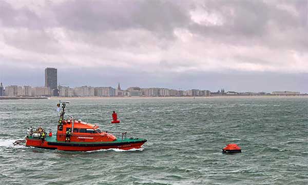
Help, I’m shark bait!
Photo: European GNSS Agency
The Galileo Search and Rescue (SAR) service was demonstrated Sept. 26 off the coast of Belgium. In Operation Shark Bait, a volunteer “victim” — Australian broadcaster Tara Foster — operated her Galileo-enabled SAR beacon from a life raft off the port of Ostend. The service quickly triggered, with the rescue initiated in under four minutes.
Wheelchair navigation
A new app launched in Portsmouth, England, helps people with limited mobility plan their travel routes. The Route4U pavement navigation app benefits both wheelchair and pram (stroller) users, allowing them to discover safer, more accessible routes across the city. The app indicates pavement obstacles, surface quality, curb heights and widths, inclines and travel distances.
Operation Shark Bait showed how this vital service can quickly trigger a rescue operation and save lives at sea. Despite a grey day and choppy sea conditions, an emergency rescue was initiated in just over three and a half minutes after intrepid “volunteer victim,” Australian broadcaster and explorer Tara Foster, operated her Galileo-enabled SAR beacon from a small life raft buffeted by the waves just offshore from the port of Ostend.
Operation Shark Bait was a specially designed demonstration of the capabilities of the Galileo SAR service that took place around the new state-of-the-art Belgian Maritime Rescue and Coordination Centre (MRCC) in Ostend with an invited audience of VIPs and media. The whole operation was streamed live over YouTube and the Europe By Satellite (EBS) TV service.
The Shark Bait test took just over three and a half minutes to locate the PLB developed under a GSA Horizon 2020 project. (Photo: GSA)
The scenario was simple. Tara was left alone at sea in a small life raft, but with a 406-MHz Cospas-Sarsat personal locator beacon (PLB). On activating the beacon, the stopwatch started. The time to receive the distress signal, compute her position and alert the relevant rescue authorities was recorded. The Belgian fast rescue boat ORKA R6 then dashed out to sea to pick her up.
Subsequently, a NH90 Cayman SAR helicopter from the Belgian 40th squadron was also scrambled to help transfer “injured” Tara to hospital.
Shark Bait was a great success with just 3 minutes 32 seconds elapsing from Tara activating her Galileo-enabled personal locator beacon (PLB) to the moment commanders at MRCC could dispatch the ORKA to her location.
The location, with an initial accuracy of 100 metres, is provided by the Galileo receiver inside the PLB to the Galileo satellites in view. The Galileo satellites then forward this information to the Cospas-Sarsat infrastructure, where the position is validated.
“The PLB used was developed under one of our Horizon 2020 projects and is the first Galileo-enabled beacon on the market,” said Fiammetta Diani, head of market development at the GSA.
Time saver, life saver
The day started at the MRCC in Ostend with a visit to the operations centre, an inspection of the ORKA Fast Rescue Boat and a chance to talk to Tara Foster before she was “castaway” on the waves.
Dries Boodts, deputy nautical director at MRCC, described the role of the center, which has a single focus on safety at sea. “The globe is divided into Search and Rescue Regions (SRRs),” Boodts said. “The MRCC oversees the Belgian maritime region that extends up to 47 miles off the Belgian coast.”
The region includes major shipping lanes and two large offshore wind energy parks. The MRCC deals with around 450 incidents each year involving a range of craft and issues from collisions at sea to war munitions recovery. It can call on an assortment of assets including its own rescue craft, police and navy vessels and the Belgian air force and the MRCC collaborates extensively with authorities in neighbouring countries.
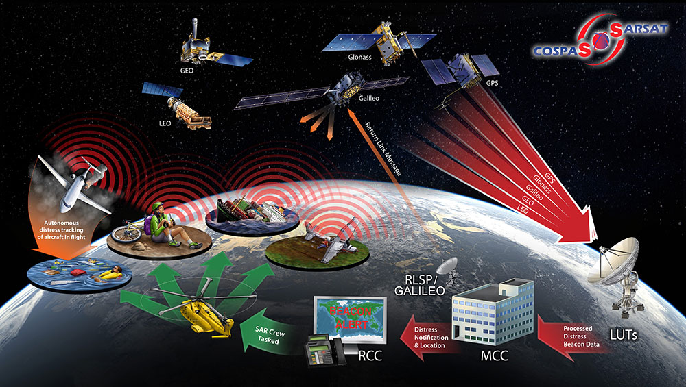
Galileo is Europe’s contribution to upgrading Cospas-Sarsat, the global satellite-based search-and-rescue system. Since its introduction in 1981, Cospas-Sarsat is estimated to have saved 45,000 lives.
The current MEOSAR (Mid-Earth Orbit Search and Rescue) upgrade is based on the EU’s Galileo satellite constellation that carries a dedicated Cospas-Sarsat payload for the 406-MHz distress beacons that give users free access to global system.
The addition of Galileo (and other GNSS satellites) to the system has already enabled a dramatic increase in performance in terms of better accuracy to locate activated distress beacons and vastly improved global coverage.
“With the Galileo system, all parts of the world will be covered at least every 10 minutes — previously this was up to four hours — and guaranteed location accuracy is reduced from 10 to 2 kilometers,” explained Jolanda van Eijndthoven from the European Commission.
As well as the 23 SAR payloads currently provided by Galileo, with more to come, the EU also provides ground infrastructure including MEO Local User Terminals (LUTs) to pick up the signals relayed from the satellites. These LUTs are not just in Europe, and a fourth facility is o be opened soon on La Reunion island to improve coverage across the Indian Ocean.
Return link reassurance
From the end of the year the Galileo system will also provide a Return Link Service (RLS) that will be able to send an acknowledgement to the victim that their distress signal has been received and help is on its way. This new ability to provide reassurance should deliver a valuable psychological lift to victims and further boost survival rates.
“The PLBs developed under our Horizon 2020 projects will be the first ones on the market to have the RLS capability,” said Fiammetta Diani.
Back on dry land, Tara confessed that the simulation had felt very real to her. “The scariest part was the transfer to the helicopter from the rescue boat,” she said. “The winch was like a lift without a floor and very fast! Stepping from the flimsy life raft to the ORKA was also not easy – those waves were high!”
“The operation went just like clockwork,” concluded Paul Flament Head of the Galileo and EGNOS unit at the European Commission’s DG GROW.
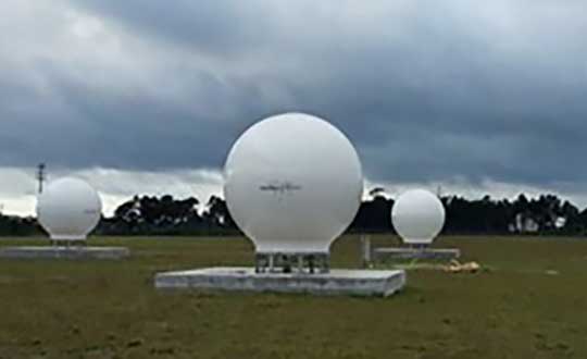
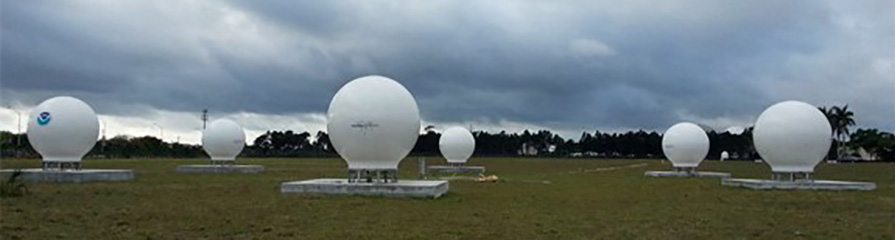
Orolia has successfully installed the first operational Cospas-Sarsat second-generation technology on search-and-rescue ground stations for the National Oceanographic and Atmospheric Administration (NOAA) in Florida and Hawaii.
The ground stations have been upgraded with second-generation beacon (SGB) signal-processing capabilities to more accurately and quickly locate the source of distress signals.
The NOAA Florida and Hawaii ground stations are the only operationally ready Medium Earth Orbit Search and Rescue (MEOSAR) ground stations in the world to receive the SGB signal specification capability.
The Cospas-Sarsat global search-and-rescue system developed specifications for the second-generation 406-MHz search-and-rescue beacon, which uses a modern, spread-spectrum signal to achieve more accurate and robust performance.
“The work performed by Orolia was exceptional, as the process of upgrading an operational system to a higher set of requirements, years after its initial design, involves minimizing downtime while validating the new requirements and revalidating the previous requirements,” said Mickey Fitzmaurice, NOAA SARSAT Systems Engineer. “The successful result makes it obvious that the engineering and operations team at Orolia put a great deal of time and effort into planning the upgrade, as the execution was seamless.”
“This series of world firsts demonstrates Orolia’s broad technical leadership in the global search and rescue ecosystem,” said Orolia Director of SARSAT Operations, Steve Ludwig. “We continually innovate to enhance the usefulness of these technologies, from generating encrypted beacon alert signals to including alert authentication through the use of Galileo Return Link Service.”
Cospas-Sarsat ground stations are called Local User Terminals (LUTs). These satellite receiving units are the ground stations that receive emergency beacon distress alerts. (Photo: NOAA)
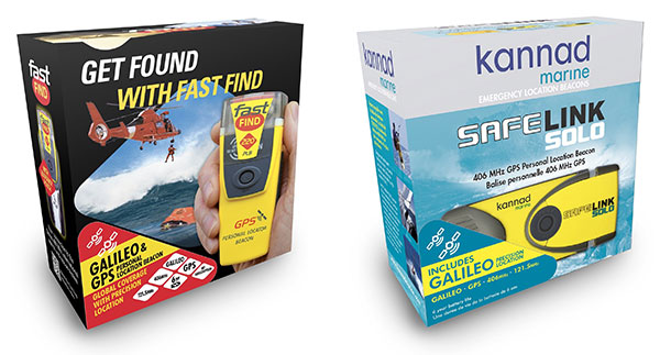
The upgraded McMurdo FastFind 220 and Kannad SafeLink Solo Personal Location Beacons. (Photo: Orolia)
Orolia’s McMurdo FastFind 220 and Kannad SafeLink Solo personal location beacons (PLB) now operate with the Galileo GNSS system.
The PLBs are the first of a series of new solutions coming from the European Union-funded Helios project, led by Orolia, which has been set up to leverage the power of the new satellite system.
With Galileo, the upgraded multi-constellation PLB receivers offer increased global coverage and support accelerated rescue missions. Location detection is enhanced and can be more precise as the PBLs receive coordinates from the Galileo satellite network in addition to GPS. Signals can even be detected in high-sided locations, such as canyons.
“We are thrilled to be launching our upgraded PLBs in the European and U.S. markets,” said Chris Loizou, vice president of maritime at Orolia. “The combination of both Galileo and GPS GNSS capability means that our customers will benefit from coverage that spans from the North to the South Pole. We work tirelessly to push the boundaries of product innovation and, ultimately, to give people the best chance of being rescued in an emergency situation.”
The McMurdo FastFind and Kannad SafeLink PLBs are part of Orolia’s comprehensive search-and-rescue ecosystem and join the McMurdo SmartFind G8 and Kannad SafePro series EPIRBs as Galileo-capable rescue beacons.
Orolia’s LEOSAR-GEOSAR-MEOSAR (LGM) Mission Control Center (MCC) solutions are now commissioned as Nodal MCCs in Spain and Australia, enabling global distribution of critical search-and-rescue information through the Cospas-Sarsat system.
With the successful commissioning of their Nodal MCCs, Spain and Australia will now be able to share critical information with the U.S. and France, providing worldwide coverage for global search and rescue.
In addition, since they will be authorized to commission other MCCs in their regions, they will also significantly advance the Cospas-Sarsat MEOSAR program.
Orolia’s McMurdo PRISMA MCC features satellite search-and-rescue technology with full LGM capability. It is the commercial solution of choice for search-and-rescue authorities in Norway, the UK and many other countries.
“We’re proud to support the world’s most critical search and rescue operations,” said Steve Ludwig, Orolia’s director of SARSAT Operations. “With Orolia onboard, you can rely on proven solutions in critical environments where failure is not an option. Our PRISMA Mission Control Center systems are the only successfully deployed, Cospas-Sarsat commissioned commercial solutions available, meeting the highest standard for search-and-rescue support.”
The Orolia PRISMA Mission Control Center. (Photo: Orolia)
Orolia has been developing global search-and-rescue programs for nearly 30 years, reaching a major milestone with the Medium-altitude Earth Orbit Search and Rescue (MEOSAR) system in 2011, and completing all global MEOSAR system installations since.
To date, 75 percent of the Earth’s surface is monitored by Orolia’s MEOSAR systems.
Through its McMurdo brand, Orolia has equipped these systems with the latest search-and-rescue technology to increase response times and save more lives worldwide.
This digital elevation model (DEM) indicates the type of data currently being acquired across Florida. (Photo: Dewberry)
High-resolution airborne lidar data to be acquired over 34,000 square miles for disaster response and recovery.
Under an active Geospatial Products and Services contract, the U.S. Geological Survey (USGS) has selected Dewberry, a privately held professional services firm, to complete a statewide lidar mapping project for Florida. The project is funded by the Florida Division of Emergency Management and USGS as part of Hurricane Irma Disaster Recovery, Response and Preparedness measures being conducted by the state and federal agencies.
The approximately $20 million project includes airborne lidar data acquisition, ground survey and preparation of bare earth point cloud and digital elevation model products for various applications to support response, recovery, and preparation for future storm events.
The resulting quality level 1 data will be primarily used for hydrologic and hydraulic modeling and many engineering applications by the water management districts to mitigate the impacts of flooding caused by these storms.
USGS and the Federal Emergency Management Agency (FEMA) will also utilize these data for various flood studies. The project encompasses an area of more than 34,000 square miles.
Photo: Dewberry
Dewberry has acquired and processed nearly 22,000 square miles of lidar data for various local, state, and federal agencies in Florida within the past three years.
“As we continue to map the state of Florida, we’re looking forward to using the best technology and personnel to complete such a vast undertaking,” said Dewberry Vice President and Director of Remote Sensing Amar Nayegandhi, CP, CMS, GISP. “Once these data are acquired and analyzed, they will be able to support USGS, FEMA, the Natural Resources Conservation Service, the Florida water management districts, and several other state and local agencies in their mission to better prepare for natural disasters and minimize loss of life and property; and use these scientific data to enhance and protect our quality of life.”
Dewberry will serve as prime contractor for this project and will perform the majority of the data production. The firm is teaming with seven other partner firms including Woolpert Inc., Quantum Spatial Inc. and Digital Aerial Solutions, Inc, which will acquire and process data to support the project.
Dewberry’s other subcontractors will be tasked with acquiring airborne lidar data.
“We have 11 aircraft with top-of-the-line airborne lidar sensors being deployed for data acquisition starting in early December,” said Dewberry Senior Project Manager Elise MacPherson, PMP. “I’m excited to manage this project and support the needs of USGS, their partner federal agencies and the many stakeholders in Florida.”
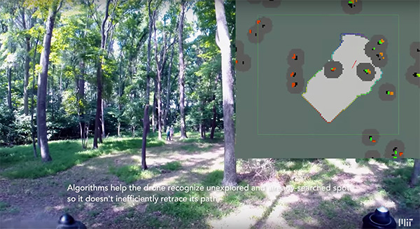
Researchers at the Massachusetts Institute of Technology (MIT) presented a project at the International Symposium on Experimental Robotics involving an autonomous drone fleet system that collaboratively mapped an environment under dense forest canopy.
Designed with search and rescue in mind, the drones used lidar, onboard computation and wireless communication, with no requirement for GPS positioning.
Each drone carries laser-range finders for position estimation, localization and path planning. As it flies, each drone creates its own 3-D map of the terrain. A ground station uses simultaneous localization and mapping (SLAM) technology to combine individual maps from multiple drones into a global 3-D map that can be monitored by operators.
The MIT team tested its concept via simulations of randomly generated forests, and world-tested two drones in a forested area at NASA’s Langley Research Center. In both experiments, each drone mapped a roughly 20-square-meter area in about two to five minutes, while the control system integrated their maps together in real-time.
The drones were programmed to identify multiple trees’ orientations, as recognizing individual trees in impossible for the technology, and individual trees’ orientation very difficult. When the lidar signal returns a cluster of trees, an algorithm calculates the angles and distances between trees to identify the cluster and determine if it has already been identified and mapped, or is a new mini-environment.
The technique also aids in merging maps from the separate drones. When two drones scan the same cluster of trees, the ground station merges the maps by calculating the relative transformation between the drones, and then fusing the individual maps to maintain consistent orientations.
The Notilo Plus team with the iBubble. (Photo: Notilo Plus)
Notilo Plus has launched iBubble, a fully wireless, autonomous and intelligent underwater drone. iBubble can accompany divers for up to an hour and down to 197 feet depth, acting as their personal cameraman and enabling superior underwater imaging.
Founded in 2016, Notilo Plus is a Marseille, France-based start-up created to develop intelligent underwater exploration technologies.
The remotely operated vehicle (ROV) was designed using Notilo Plus’ patented underwater localization technology, enabling subaquatic adventures without tethers. It comes with an advanced artificial intelligence system, offering total autonomy and self-learning capabilities.
The localization technology is mainly based on acoustic signal transmission and image recognition (video tracking). By combining these technologies, iBubble is able to locate precisely its target underwater and thus shoot perfectly stable footage.
iBubble is equipped with an obstacle avoidance system, which allows it to smoothly follow a diver, while obtaining images of unparalleled quality for personal or commercial use, the company said. It features real-time image recognition, a stabilization system and direct surface control, bringing outstanding performance to underwater imaging.
The iBubble ROV is an environmentally conscious device — it does not disturb the fragile marine ecosystem thanks to its minimal noise emission levels and its obstacle-avoidance capability.
iBubble can be used for sports and entertainment filming, diving instruction, wildlife protection, search-and-rescue operations, naval or underwater infrastructure maintenance, and subsea patrolling.
“We are excited to introduce to the world the first fully wireless, autonomous underwater drone,” said Nicolas Gambini, CEO of Notilo Plus. “With the countless cutting-edge technologies brought by the iBubble, coupled with its ability to bring exceptional pictures and video footage, this is a remarkable and versatile device for any diving activity.”
The device is now available for order globally. The first batches of iBubble drones will be delivered to the customers, including the Indiegogo crowdfunding campaign supporters, from mid-November 2018.
Galileo satellites GSAT0215, GSAT0216, GSAT0217 and GSAT0218, launched in December 2017, were commissioned for operational use as of Oct. 12, with all signals usable: Open Service, Public Regulated Service and Search and Rescue Service.
This increases the number of Galileo satellites that are available for service provision to 18. Initial operational capability for the constellation was declared on December 15 2016.
The additions to the GNSS almanac include the following:
GSAT0215: space vehicle E21 aka Nicole, occupying slot A03 if the constellation, with its payload running on a phased hydrogen maser (PHM) clock.
GSAT0216: E25, Zofia, slot A07, PHM clock.
GSAT02017: E27, Alexandre, slot A04, PHM clock.
GSAT0218: E31, Irina, slot A01, PHM clock
Each satellite weighs 715 kilo; measures 2.7 x 1.2 x 1.1 meters with a deployed solar array span of 14.67 meters; has onboard power of 1,900 W; and broadcasts navigation signals in 3 bands: E5, E6 and E1. Design life of the new satellites is more than 12 years.
Satellites GSAT-219 (Tara), GSAT-220 (Samuel), GSAT-221 (Anna) and GSAT-222 (Ellen) were launched on July 25 and are currently listed as under commissioning.
Galileo status information
Updated information on the status of the Galileo constellation can be found in the Constellation Status section of the European GNSS Service Centre’s (GSC’s) website.
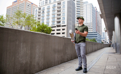
Delivery person uses Galileo on a mobile device to deliver a package. (Photo: GSA)
According the the European GNSS Agency (GSA), more than 100 million devices are using Galileo today.
To keep track of Galileo-enabled devices serving a variety of needs as they become available, visit usegalileo.eu.
The Galileo Initial Services allow the use of Galileo Open Service (OS), which enables a free of charge, global ranging, positioning and timing service for the OS users.
Galileo is interoperable with the GNSS constellations (GPS, GLONASS, Beidou). By offering dual frequencies as standard, Galileo is set to deliver real-time positioning accuracy down to the meter range.
For questions about Galileo, contact the GSC Helpdesk.
Four Galileo satellites were added to constellation in October 2018. (Image: GSA)
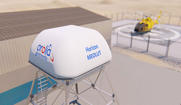
Orolia has introduced the McMurdo Horizon system, an S- and L- band compatible phased array system featuring antennas developed by Ball Aerospace with horizon-to-horizon coverage to capture search-and-rescue signals relayed from orbiting satellites immediately after line-of-sight is established.
The McMurdo Horizon system is now available to enhance regional search and rescue services worldwide with technology to complement existing and emerging ground-based systems at Medium-altitude Earth Orbit Search and Rescue (MEOSAR)ground stations.
Orolia’s McMurdo Horizon Medium Earth Orbit Local User Terminal (MEOLUT) can deliver enhanced search and rescue coverage and second-generation signal processing capabilities, in a compact form factor with no moving parts. The key technology innovation, based on a modified off-the-shelf phased array antenna developed by Ball Aerospace, is a custom-designed Orolia solution.
By pointing to satellites near the horizon, the McMurdo Horizon MEOLUT can detect and locate emergency beacons much farther away. This enhanced detection ability, combined with the McMurdo Selective Schedule Algorithm, enables the system to monitor more diverse regions, including the translation of oblong and irregular data points that are invisible to traditional systems.
The European Commission (EC) has awarded Thales Alenia Space a contract to develop and build an operational ground station on La Reunion Island to track GNSS satellites in medium Earth orbit. The ground station will be an operational part of the Galileo search-and-rescue (SAR) system.
The contract includes one Medium Orbit Local User Terminal (MEOLUT), engineering support and maintenance services for one year, and the hosting site on La Reunion Island.
Using Thales Alenia Space’s powerful and compact MEOLUT Next phased-array solution, the EC and European GNSS Agency (GSA) will improve their contribution to the Cospas-Sarsat system.
Thales Alenia Space is a joint venture between Thales (67 percent) and Leonardo (33 percent).
The ground station will receive and process 406-MHz distress beacon signals from the MEO satellites being tracked, and relay them to the SAR/Galileo network via the French Mission Control Center (FMCC) at the CNES facility in Toulouse. The contract also included the procurement of the best possible hosting site for this ground station.
Image: International Cospas-Sarsat Programme
This MEOLUT Next will enhance the EC’s contribution to the Cospas-Sarsat SAR system by extending its coverage in the South Indian ocean, contributing to worldwide coverage. It complements the three MEOLUTs that are already deployed around Europe — in Larnaca (Cyprus), Maspalomas (Grand Canaria) and Spitzbergen (Norway) — and under responsibility of the GSA.
The MEO system, which replaces the legacy LEO (low Earth orbit) system, is designed to offer a faster response and better location data in near real time for search-and-rescue authorities, using spacecraft and ground facilities to detect and locate signals from the 406-MHz distress beacons.
The MEOLUT Next will also support the second generation of Cospas-Sarsat beacons. The SAR/Galileo site on La Reunion will be fitted with reference and calibration beacons to monitor the performance of the extended SAR ground segment and precisely calibrate MEOLUT measurements.
“Using Thales Alenia Space’s powerful and compact MEOLUT Next phased array solution, the European Commission will benefit from the world’s first spaceborne search & rescue system of this type,” said Philippe Blatt, vice president, Navigation France at Thales Alenia Space. “We are very proud that our advanced technology is now recognized by many customers worldwide. The performance logged by our MEOLUT Next units in service far exceeds requirements, which not only benefits our customer countries, but also makes travel even safer. It’s worth remembering that the Cospas-Sarsat system, operational since 1988, saves some 1,500 lives a year.”
Thales Alenia Space designs, operates and delivers satellite-based systems for governments and institutions, helping them position and connect anyone or anything, everywhere. Since commissioning in 2016, MEOLUT Next has delivered unrivaled performance, detecting distress signals from more than 5,000 kilometers away. Several countries have already chosen or are interested in the technology, including Canada and Togo.
Orolia has introduced its latest military technology innovation, the SecureFind Combat Rescue Beacon, at the 2018 AUSA Annual Meeting in Washington, D.C.
In addition to protecting the most critical assets and leaving no one behind, combat search and rescue (CSAR) technology can significantly enhance military operations by avoiding the loss of sensitive information and technology, avoiding hostage situations and helping to prevent conflict escalation.
SecureFind is based on Orolia’s search-and-rescue technology suite, selected by military forces for CSAR missions. The wearable base unit includes an open channel search-and-rescue solution, for military use in training or test mode. It can also be configured with a customer-defined, secure channel solution for covert operations.
The versatile CSAR solution operates with a silent, push-button functionality that does not require voice activation. SecureFind enables military forces to precisely and safely execute CSAR missions, with optional Assured PNT (positioning, navigation and timing) technology that prevents GPS signal interference, spoofing and jamming, the company said.
“There is no greater need for urgency, stealth and precision than when military personnel are isolated in rugged environments or behind enemy lines,” said Paul Zweers, Orolia’s vice president of defense programs.
“Software-defined, wearable communications technology is now more important than ever on today’s air, land, sea and cyber battlefields,” added Orolia CEO Jean-Yves Courtois. “CSAR missions are just the beginning of potential uses for this resilient military technology, which can ensure reliable positioning, navigation and timing data in any operating environment. Orolia’s solutions are tailored to support today’s soldiers and engineered with a view toward the future of global military networks.”
According to Orolia, the standard SecureFind solution is available at a price point that could enable thousands of warfighters to benefit from the new battlefield technology. More advanced functionality is also available, such as the ability to change signals on-the-go for additional security, to detect and mitigate GPS jamming and spoofing, and to generate important strategic information such as virtual battlefield maps of jamming and spoofing activity.
Orolia offers a cost-effective, modular approach to assured PNT, with a flexible, open architecture that integrates easily with legacy systems. This layered platform meets critical technology requirements without over-engineering a solution that is complex, expensive and difficult to maintain.
Additional SecureFind product information is available at the AUSA Annual Meeting, Orolia booth #8051.