DJI, maker of unmanned aerial vehicles, and DroneSAR, an Irish tech start-up for search and rescue, on Thursday announced a new search and rescue app that seamlessly integrates a drone’s unique aerial perspective on life-and-death searches into incident management software, ensuring rescue crews can use drones effectively to save lives.
DroneSAR can stream live images and video, from a regular or thermal imaging camera, to an incident command center as well as other rescue teams on the ground. The software can tag the GPS coordinates of a victim and automatically transmit them by email or SMS, enabling ground crews to reach victims more quickly. Completed search patterns are all recorded and logged for easy handover to oncoming rescue crews.
The app takes into account various types of terrain, allowing the drone to fly patterns to survey an area faster and more effectively. Flight paths can be adjusted for any terrain including hills, mountains, trees or flat land. The software allows users to choose an automatic aerial search pattern based on variables such as altitude, field of view, battery life and probability of detection. By organizing the process of data collection and providing a framework to manage and analyze it, DroneSAR ensures drones can be used methodically as part of a rescue protocol, allowing personnel to work more safely and effectively.
“From understanding on how to use the technology, to communicating findings and data, to figuring out the most appropriate tactical approach, first responders can benefit greatly from this software app on our DJI hardware,” said Romeo Durscher, director of Education at DJI. “Many of the tasks and strategies deployed during a search and rescue operation can get sped up with automation, helping to reduce the time it takes to find a victim and save lives.”
The software was developed based on research done by DJI in conjunction with the European Emergency Number Association and Ireland’s Donegal Mountain Search and Rescue team. The groups found that while a five-person rescue team on foot needs an average of two hours to find a victim in one square kilometer, a drone can do the job in 20 minutes or less while taking additional active steps to achieve a successful rescue.
“Our aim is to save lives,” said Oisin McGrath, co-founder and CEO of DroneSAR. “Our software will reduce risk to search teams and reduce search time. If we can save just one life, that is mission success for us at DroneSAR.”
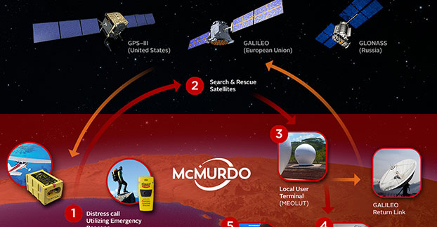
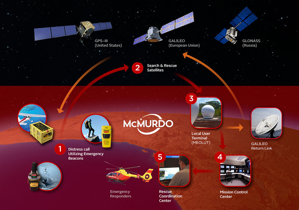
Emergency preparedness company McMurdo has launched a new family of Emergency Position Indicating Radio Beacons (EPIRBs) that will accelerate the search-and-rescue process by combining multiple frequencies — including GNSS — into a single EPIRB product.
The McMurdo SmartFind and Kannad SafePro EPIRBs are distress beacons that can support each of the four frequencies used in the search-and-rescue process: GNSS for location positioning, 406 MHz and 121.5 MHz for beacon transmission, and Automatic Identification System (AIS) for localized connectivity.
The multiple-frequency capability will ensure faster detection, superior positioning accuracy, greater signal reliability and, ultimately, accelerated rescue of people or vessels in distress, the company said.
Expanded satellite connectivity. McMurdo SmartFind and Kannad SafePro EPIRBs have a multiple GNSS satellite constellation receiver supporting Galileo (once the constellation is fully operational), GPS and GLONASS — from a single beacon. Advanced GNSS data processing results in faster detection of positioning coordinates and enhances the accuracy of the emergency location.
Most of today’s EPIRBs use 406 MHz and 121.5 MHz frequencies via satellite communication to provide location and positioning data to global search and rescue personnel who may be several hundred miles away.
The additional AIS channels on the new McMurdo SmartFind G8 AIS and Kannad SafePro AIS EPIRBs will send position signal information to standard AIS electronic equipment on nearby vessels for complementary, local tracking and rescue capabilities. This global and local rescue capability will result in quicker signal detection and faster response times.
The McMurdo SmartFind and Kannad SafePro EPIRBs are part of McMurdo’s comprehensive search and rescue ecosystem. As the world’s provider of an end-to-end search and rescue ecosystem — including distress beacons, satellite ground stations, mission control and rescue coordination systems, and rescue response products — McMurdo builds, integrates and tests products as part of a live search and rescue system. This ensures greater cohesion between distress signal transmission and reception so that beacon owners can feel confident that their signals will get to search and rescue authorities quickly.
MEOSAR compatibility. The McMurdo SmartFind and Kannad SafePro EPIRBs are designed to be fully compatible with MEOSAR, the next generation of the Cospas-Sarsat international search-and-rescue satellite system that has helped to save over 40,000 lives since 1982. MEOSAR will increase the speed and accuracy of beacon signal detection and location with new MEOSAR ground network infrastructure and additional MEOSAR satellites.
When fully deployed, a MEOSAR-compatible beacon can be located with an accuracy of location within 100 meters (328 feet), 95 percent of the time — and within five minutes of distress signal activation, all without reliance on GNSS.
McMurdo manufactures approximately 50 percent of the world’s MEOSAR infrastructure and is also leading the design of additional MEOSAR-capable beacons under the European Union’s Horizon 2020 Research and Innovation Program’s HELIOS project.
“McMurdo’s new EPIRB announcement is a major step towards achieving a unified search-and-rescue vision,” said Bruce Reid, CEO of the International Maritime Rescue Federation. “The convergence of products and systems whether AIS and 406 MHz or maritime domain awareness and search and rescue, respectively, will require a comprehensive understanding of the entire search and rescue ecosystem. I look forward to seeing more McMurdo solutions and innovations that will shape the search and rescue industry for years to come.”
The McMurdo SmartFind and Kannad SafePro distress beacons support beacon transmission, GNSS for location positioning, and AIS for localized connectivity.
Drone-maker DJI and Shapeways, a 3D printing service and marketplace, are challenging designers to create unique 3D printed accessories for drones to improve search-and-rescue products and make it easier to help save lives.
DJI wants to encourage creativity and enable its customers to design their own products through its Software Development Kit. Since 2013, drone enthusiasts have used Shapeways to create add-ons for their personal drones and offer them for sale in the Shapeways marketplace.
DJI’s Phantom 4 with its integrated camera and long range can be used as a search drone. DJI said the challenge is to make it the “ultimate rescue drone.”
For instance, severe weather and rough waters are classic hallmarks of ocean rescue, complicating an already challenging rescue operation — finding a person or a vessel in a large area of water.
By adding 3D-printed accessories that can improve a drone’s visibility, carry payloads and land on water, first responders could cover more area, cutting response times while monitoring difficult waters.
“This challenge means more lives could be saved with fewer first responders put at risk,” said Eli Morgan Harris, DJI business development director. “The 3D-printed drone modification products developed through this challenge could make a huge difference — even save lives.”
In Europe, the POSEIDRON UAV took top honors in the 2015 European Satellite Navigation Competition with its remote-controlled multicopter built to support maritime search-and-rescue services.
Reynolds is director of Inta Communication Ltd. and a long-term Brussels observer writing on many aspects of European government policy and implementation for a range of clients and publications. He is the contributing editor for GPS World’s new quarterly e-newsletter, EAGER: the European GNSS and Earth Observation Report.
The annual summit, held in the historic Munich Residenz, is an conference with global impact dealing with satellite navigation. The one-of-a-kind convention of high-ranking worldwide speakers from industry, science and governments provides the participants with a broad overview and different perspectives on the latest developments in the field of GNSS.
Reynold’s session, GNSS and Sciences for Life, will cover maritime search and rescue (SAR), precision agriculture and livestock management, personal fitness and emergency medical attention.
Other sessions include:
GNSS Program Updates — Global systems, chaired by Hank Skalski, Department of Transportation, DOT Liasion to Air Force Space Command, Peterson Air Force Base, USA
GNSS Program Updates — Regional and augmentation Systems, chaired by Dr. Todd Walter, Stanford University, CA, USA
GNSS in the Southern Hemisphere and Equatorial Regions, chaired by Prof. Vidal Ashkenazi, Chief Executive of U.K.-based Nottingham Scientific Ltd, Nottingham, UK
Precise Positioning Technology in Agriculture and Forestry, chaired by Dr. Herbert Landau, Managing Director, Trimble Terrasat GmbH, Hoehenkirchen, Germany
Legal Issues of GNSS Timing, chaired by Dr. Ingo Baumann and Dr. Oliver Heinrich, Partner, BHO Legal, Cologne, Germany
Plus, expect a brand-new conference format for this session:
The GNSS Knowledge Triangle: Tying the Knot Between Education, Research and Industry, chaired by Dr. Fabio Dovis, Associate Professor, Politecnico di Torino, Turin, Italy
The summit is part of the efforts of the Bavarian government and the cluster on aerospace and satellite navigation to stimulate applications and services in this high-tech field.
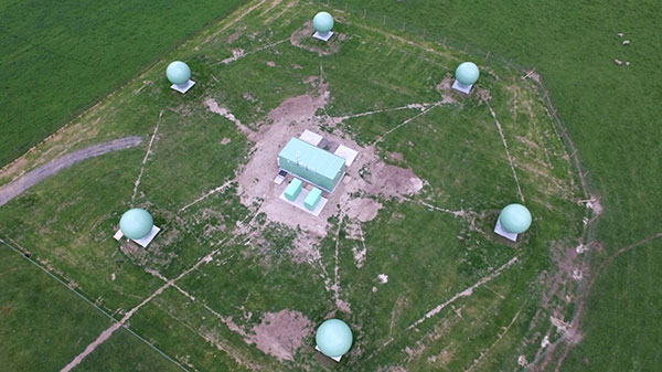
Emergency readiness and response company McMurdo has completed the installation of a six-antenna next-generation Medium-Earth Orbit Search and Rescue (MEOSAR) satellite ground station system in New Zealand.
The project, which is part of a joint initiative with Maritime New Zealand and the Australian Maritime Safety Authority, is expected to significantly boost search-and-rescue capability in the New Zealand and Australia search regions and marks the first implementation of MEOSAR in Asia Pacific.
MEOSAR is the next-generation version of Cospas-Sarsat, the international search-and-rescue satellite system that has helped to save 37,000 lives since 1982. Cospas-Sarsat is in the process of upgrading its satellite system by placing search-and-rescue transponders on new GPS, GLONASS and Galileo satellites. Once qualified as operational, this system augmentation will dramatically improve both the speed and location-accuracy for detecting beacons.
In a typical satellite-based search-and-rescue scenario, ships, aircraft or individuals transmit distress signals from an emergency location beacon via satellite to a fixed ground receiving station or local user terminal. The ground station receives and calculates the location of the distress signal and creates and sends an alert to the appropriate rescue authorities. Today, the beacon-to-alert process depends on a limited number of low Earth orbit (LEO) satellites and may take several hours before a position is confirmed. With MEOSAR, beacon signals will be received more quickly and beacon locations identified with greater accuracy thereby reducing this time to minutes.
“Beacons can take the ‘search’ out of search and rescue, and the MEOSAR system will dramatically increase the global search-and-rescue capability,” said Maritime New Zealand Director Keith Manch. “Emergency distress beacons are key equipment for anyone operating at sea, on land and in the air – whether commercially or recreationally — but they can’t operate without sites like this.”
“This key installation firmly establishes McMurdo as the premier MEOSAR infrastructure provider globally,” said Remi Julien, McMurdo president. “We are committed to partnering with both Maritime New Zealand and the Australia Maritime Safety Authority to ensure that they have the technology, training and long-term support in place to significantly reduce search-and-rescue times and, ultimately, save more lives today and in the future.”
The New Zealand MEOSAR system, and another being installed in Western Australia, will cover one of the largest search-and-rescue areas in the world — from north of Australia/New Zealand to the Equator and south to the South Pole, east to half way across the Pacific, and west half way across the Indian Ocean. The systems will undergo rigorous testing before being officially brought online in late 2017 by Cospas-Sarsat.
There are 58,000 emergency distress beacons registered in New Zealand which, without any changes or updates, will be immediately usable by the new systems. It is estimated, however, that an additional 25,000 beacons are unregistered. Due to the high responsiveness of the MEOSAR system, search-and-rescue authorities strongly recommend beacon registration. This will help the unnecessary deployment of search-and-rescue resources due to inadvertent beacon activations. The Rescue Co-ordination Centre New Zealand, part of Maritime New Zealand, responds to 550 beacon alerts a year.
When I was the GIS manager of the Atlanta Regional Commission, the most rewarding and important work we did was geospatial support for our first responders. The culmination of this effort was creation of a portable GIS that we could set up in the field on short notice anywhere in the region to provide situational awareness for first responders.
The system consisted of two laptops, external hard drives, a HP “E”-size plotter, foam-board laminator and an LCD projector — all housed in a portable tent. We used ArcInfo and ArcView to build and overlay vector data on ortho/oblique aerial imagery to aid visualization.
We found that police and firefighters especially liked our large laminated plots of imagery overlaid with street data, because the aerial images were easy to understand and the GIS data provided needed location references. The hard-copy plots required no computer and could be marked up with grease pencils.
Helping in our small way, we provided the same kind of large plots of New Orleans to the Louisiana National Guard days after Hurricane Katrina hit. We later learned that the plots were used by National Guard headquarters to keep track of search-and-rescue efforts by marking up neighborhood blocks with grease pencils and recording search results. They crossed off buildings that had been searched and recorded urban rescue information such as who did the search, and the date and number of live or deceased bodies found. The hard-copy plots were a low-tech embodiment of higher tech GIS data and imagery.
Nine years later, the National Geospatial-Intelligence Agency (NGA) developed a similar but higher tech and more robust system called GeoQ.
GeoQ: Geographic Work Queueing and Tasking System
GeoQ is an open-source geographic tasking and management system that facilitates collection and display of diverse geographic and geographically tagged data across large areas to provide situational awareness for all involved. As needed, the large areas can be broken down into small grid squares and assigned to teams or team members for detailed analysis or tasking.
The system is designed to be very transparent so all involved can view the workflow and assist as needed, while avoiding duplication of effort. This NGA video is a well done and rapid overview of GeoQ.
GeoQ software was developed by NGA and the MITRE Corporation to leverage NGA tools and data to the benefit of Homeland Security personnel. In 2013, the leadership at NGA made a gutsy decision to share some of their unclassified geospatial tools with the nation’s first responders through GitHub, an open-source software developers’ online collaboration environment. With more than 2 million participating programmers, GitHub hosts more software source code than any other single service in the world.
GeoQ was the first NGA product shared through GitHub, and was in keeping with a change in philosophy at NGA to take advantage of feedback and improvements generated by the huge and diverse talent pool available through GitHub. NGA was the first intelligence agency to share some of its work in this open-source environment, and the results have been extremely beneficial to all involved.
The Huntsville Connection
With more than 70 geospatial firms and agencies, Huntsville, Ala., has always been an early adopter of geospatial technology. Several years ago it was again a Huntsville team that developed a first-ever Google Earth Enterprise-based emergency response system called Virtual Alabama. The system was so effective that eight other states adopted the model. Work was underway to build a national version when Google announced the phasing out of Google Earth Enterprise. We now know that Google was not motivated to build authoritative geospatial systems, but was focused on building products and services that attracted customers so it could accomplish its primary business of selling advertising.
Fortunately, the work of the Virtual Alabama team was not wasted. Team members became experts regarding first-responder operations and their unique situational awareness requirements. They learned that first responders needed much more than just a GIS. The best analogy I can think of is that one could use PowerPoint as a word processor, but that wouldn’t be a very efficient system. Likewise, MS Word could be used for presentations, but not as elegantly as PowerPoint. The same holds true for rapid dissemination, communication and perception of a common operational picture. Geospatial tools and analysis are part of situational awareness, but the work flow and many components are different, not necessarily spatial and need to be assembled and processed at their own pace.
The timing was almost perfect, since GeoQ was released as Google Earth Enterprise was being phased out. Huntsville again seized the opportunity to build on its experience, and GEOHuntsville became a prime GeoQ testbed. I recently met with Chris Johnson, one of the early Virtual Alabama leaders and president of A Visual Edge, Inc., a Huntsville geospatial firm. She demonstrated GeoQ and Huntsville’s role in advancing the technology.
GitHub has a very thorough description of GeoHuntsville, a non-profit 501c6, and its role with NGA to test and share lessons learned through a “Blueprint for Safety” pilot project involving other cities to improve rapid disaster response. The sharing of lessons learned, code sets and documentation through the multi-city collaboration is called “Exemplar City.”
Another aspect of the Blueprint for Safety is support of rapid sensor deployment in support of first responders through common standards. Sort of a “plug-and-play” for complex devices. (See the GeoQ projects page and the OpenSensorHub.)
There is quite an extensive collection of material on GitHub regarding GeoQ and other NGA, projects including support of FEMA and GeoQ technical specifications. NGA doesn’t directly support these efforts, with legal language such as “NGA assumes no responsibility for the use of the software by any parties, and makes no guarantees, expressed or implied, about the software quality, reliability, or any other characteristic.” Still, NGA is behind the creation of the software and is working on other tools and support that will expand the capabilities. Participation of both GeoHuntsville and the Federal Emergency Management Agency (FEMA) bodes well for future use, since I don’t envision the same situation we ran into with Google and Virtual Alabama/USA.
Update on What3Words
In February, I wrote about what3words. The simple what3words system is now available as a locator, accessible via the Esri ArcGIS platform.
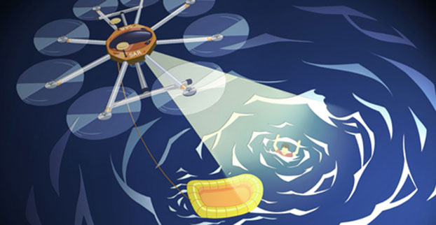
A UAV project, POSEIDRON, took top honors in the 2015 European Satellite Navigation Competition, which recognizes the year’s best innovations in commercial applications of satellite technology. POSEIDRON won over the international jury of experts with its remote-controlled multicopter built to support maritime search-and-rescue services — and took home the grand prize ahead of the European Satellite Navigation Competition’s 29 other winners.
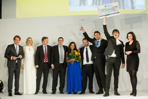
The award ceremony took place during the Satellite Masters Conference. The ceremony was held at the ddb forum in Berlin Oct. 20. The awards ceremony was held in conjunction with the Copernicus Masters awards for Earth observation.
Thorsten Rudolph, Ulrike Daniels (both Anwendungszentrum GmbH), David Argiles (ValSpace Consortium), Rudesindo Hernando Meliá, Maria Dolores Albiol Simo, Manuel Pedreira Gimenez, Jorge Esteve Ripollés and Enrique Martínez Asensi (all Sincratech Aeronautics) and Dorothee Bär (German Federal Ministry of Transport and Digital Infrastructure (BMVI)). (Photo: Anna Kreuz)
Enrique Martínez Asensi and his winning team hope to see Poseidron save lives far out at sea when people fall overboard or are involved in shipwrecks that occur during illegal immigration. Custom-developed by Sincratech Aeronautics — a start-up based in Valencia, Spain — POSEIDRON can be launched from ships or platforms under virtually any weather conditions. The multicopter uses thermal cameras and the European positioning service EGNOS to quickly locate people in the water and transmit an alarm to rescue teams along with precise information. Capable of carrying up to 70 kilogrammes, it can also transport a dinghy and deploy it as soon as casualties are found. This is what makes POSEIDRON both faster and more cost-effective than other rescue systems, which in turn significantly increases the chances of survival — particularly in cold waters.
In addition to winning the ESNC’s EUR 20,000 grand prize, the innovative project will now have the chance to enter a 12-month incubation programme at one of five Science Parks in Valencia as part of the region’s prize.
The ESNC set a new participation record this year, with 515 innovations entered by companies from more than 40 different countries around the world. The competition more than matched the successes of past editions in increasing its overall figures to 272 winners awarded and 3,343 ideas received from more than 10,000 participants throughout its 12 years in existence.
“Time synchronization and reliable positioning information are essential to today’s digital economy: Without corresponding satellite-based services, the development of these and other innovations — including the Internet of Things, machine-to-machine communication, and Industry 4.0 — would not be possible,” explained Thorsten Rudolph, CEO of ESNC initiator and organiser Anwendungszentrum GmbH Oberpfaffenhofen. “As the ideas submitted to this year’s ESNC have shown to impressive effect, it is these forward-thinking technologies in particular that present a great deal of potential waiting to be unleashed by high-tech start-ups.”
Under the patronage of the German Federal Ministry of Transport and Digital Infrastructure (BMVI), the ESNC presented prizes valued at approximately EUR 1 million in total at its festive Awards Ceremony.
The competition’s jury of 240 renowned experts selected both the overall victor and 30 other regional and special prize winners. With their innovations in areas such as connected mobility, smart cities, tourism and environmental protection, these entrants demonstrated how fundamental precise satellite navigation signals are to Europe’s digital society.
2015 Winners
Overall Winner
Loles Albiol Simó, Rudesindo Hernando Meliá, Jorge Esteve Ripollés, Manuel Pedreira Giménez, Enrique Martinez Asensi :: OVERALL WINNER – Valencian Community / Spain POSEIDRON: Remotely Piloted Aircraft System for Search and Rescue and Environmental Defence
Special Prize Winners
Rafael Olmedo, Juan Domingo, Laura Concepción :: GSA
KYNEO: The Open Navigation Platform for the GNSS of Things (Read more abut this prize here.)
Su Zhenzhong, Tonio Gsell, Alexander Wolf :: ESA
RTKNAV – A Low-Cost, Compact, User-Friendly, Centimetre-Accurate, Real-Time Navigation Solution
Dariusz Tanajewski, Grzegorz Grunwald :: DLR
Mobile Underwater Positioning System (MUPS)
Jukka Talvi, Joni Jämsä, Kalle Arola, Jukka-Pekka Alanissi, Antti Koponen :: BMVI/BMWi
HALI – Always Green Traffic Signals for Emergency Vehicles
Prof Dr Nick van de Giesen, Dr Eugenio Realini :: University Challenge
GNSS Monitoring of Precipitable Water Vapour over East Africa Using Low-Cost Receivers
Jasper Ettema, Sabine Ettema :: GNSS Living Lab
Position-Based Assistance in Case of Sudden Cardiac Arrest
Regional winners
Suresh Babu Mandalanka :: Asia
GeoKey – A Locking System That Uses Geographic Locations as Keys
Jasper Ettema, Sabine Ettema :: Austria
Position-Based Assistance in Case of Sudden Cardiac Arrest
Dr Walter Naumann :: Baden-Württemberg / Germany
ICARUS – A New Global Tracking Service for Small Objects
Ladislav Bartuška :: Czech Republic
Biological Protection of Airports Using Drones
Ronny Webers, Bart Lenaerts, Vincent Jorissen :: Flanders / Belgium
JobWalkr – The First Mobile App That Informs You About Job Opportunities in Your Neighbourhood
Daniel Neveux D’Agata, Laurent Kerbrat, Maïwenn Penhouët :: France
WIZAR – A new way to discover history and heritage
Alberto Gonzalez, Antonio Vazquez, Bibiano Fdz-Arruti, Aaron Nercellas, Diego Hurtado, Diego Nodar, Fernando Aguado, Franco Pérez :: Galicia / Spain
Point&Pin – Remote Localisation for Emergency Situations
Oscar Serradilla :: Gipuzkoa / Spain
Pothole Avoider
Sibylle Geiger, Jens Liebau, Nezar Mahmoud :: Hesse / Germany
Discover a Great Variety of Local Foods with the frimeo App
Aidan Flanagan, Colm Murphy :: Ireland
112GPS.com – More accurate emergency calls
Ronen Bitan, Tal Lavi :: Israel
Trailze – Complete Outdoors Experience
Dr Saulius Rudys, Mantautas Rudys :: Lithuania
Fully Camouflaged GNSS-GSM Anti-Theft System for Bicycles
Carlos Callejero Andrés, Julio Pantoja Dominguez, Ignacio Gómez Maqueda :: Madrid / Spain
VardiaN – Big Data Platform of Connected PPEs to Prevent Accidents in Hazardous Environments
Prof Dr Nick van de Giesen, Dr Eugenio Realini :: The Netherlands
GNSS Monitoring of Precipitable Water Vapour over East Africa Using Low-Cost Receivers
Thomas Jelle, Ingjard Sandhei, Åsmund Tokheim, Dag Jomar Mersland, Morten Tvenning, Iván Sánches Ortega, Robert Badnall :: Norway
MazeMap – High-quality, interactive, searchable, and linkable indoor maps
Jan Filipowiak, Radoslaw Jastrzebski, Maciej Glowacki :: Poland
Pastguide: Virtual Reality in Real Places
Florin Banica, Andreea Diana Banica :: Romania
Shared Ahead – A Truck-Sharing System
Su Zhenzhong, Tonio Gsell, Alexander Wolf :: Switzerland
RTKNAV – A Low-Cost, Compact, User-Friendly, Centimetre-Accurate, Real-Time Navigation Solution
Zoe Farrington, Andrew Richardson :: United Kingdom
REALRIDER®
Loles Albiol Simó, Rudesindo Hernando Meliá, Jorge Esteve Ripollés, Manuel Pedreira Giménez, Enrique Martinez Asensi :: Valencian Community / Spain
POSEIDRON: Remotely Piloted Aircraft System for Search and Rescue and Environmental Defence
Nicolas de Kerchove, Joel Mendez, Oscar Marí :: Wallonia / Belgium
A New Concept for a Location-based Mobile Game with an Innovative Monetisation Platform
In a typical Cospas-Sarsat search and rescue process, a distress beacon signal is sent via satellite to a local user terminal. A mission control center validates the emergency and sends critical information to rescue coordination centers. MEOSAR, the next-generation version of Cospas-Sarsat, will provide several unique features including a return link service function to acknowledge receipt of the distress signal.
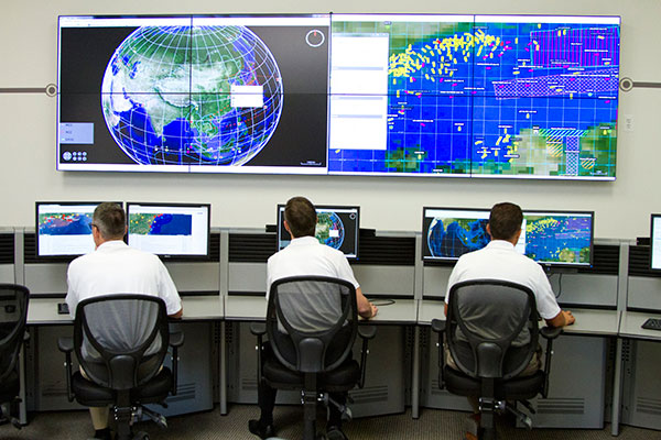
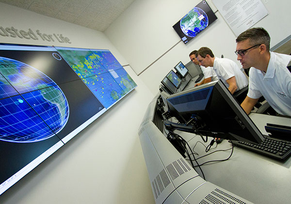
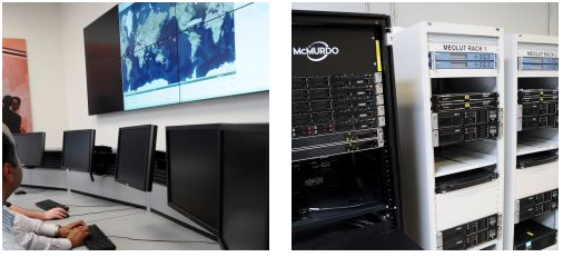
McMurdo has introduced PRISMA MCCNet, a new software solution with several new features to improve the Cospas-Sarsat satellite-aided search and rescue process, and for use in the future MEOSAR system. The software, which is part of McMurdo’s suite of PRISMA (Preparation, Response, Identification, Surveillance, Management, Acceleration) software solutions, provides mission control center (MCC) operators with critical tools to better identify, locate and manage distress situations.
In a typical Cospas-Sarsat search and rescue scenario, a distress signal from an emergency beacon is sent via satellite to a fixed ground receiving station or local user terminal. The nearby MCC confirms the emergency, analyzes location data and provides this information to the various rescue coordination centers for the actual rescue operation. PRISMA MCC’s improved functionality includes built-in system redundancy, unified communications and automated reporting to improve the MCC operation and streamline the search and rescue process.
The international Cospas-Sarsat satellite system is best known for detecting and locating emergency beacons activated by aircraft, ships and backcountry hikers in distress and has been credited with saving 37,000 lives since 1982. The system includes satellites in low-altitude Earth orbit (LEO) and geostationary Earth orbit (GEO). The future Cospas-Sarsat system will include medium-altitude Earth orbit (MEO), which will form the MEOSAR system. Satellites in the MEOSAR system include GPS, Galileo and GLONASS satellites, which are incorporating search and rescue payloads.
“PRISMA MCCNet provides Mission Control Center operators with a powerful, comprehensive and reliable software tool that provides the most accurate data and most up-to-date information to expedite the search and rescue process,” said Jacob Blankenship, search and rescue business manager for McMurdo. “With several advanced features and innovative functions based on our years of experience working with the leading search and rescue authorities around the world, the end result will be faster decision making and, ultimately, more lives saved.”
McMurdo’s PRISMA MCCNet software will help improve a Cospas-Sarsat satellite-aided search and rescue system that has helped to save 37,000 lives since 1982.
PRISMA MCCNet provides significant improvements in several key areas to enhance mission control center operations including:
High Availability with Support for Automatic Failover — PRISMA MCCNet includes new automatic failover and built-in redundancy features to maximize availability and uptime of the search and rescue system.
Unified Inbox and Communications — Easy to use and organize, PRISMA MCCNet’s Unified Inbox displays all actionable events that require operator interactions including beacon alerts, narrative messages, or system level alarms on a single screen. This information, which traditionally required the use of multiple screens, can be sent easily and reliably to rescue authorities via multiple communications protocols and redundant link transmission.
Advanced Monitoring and Reporting — PRISMA MCCNet’s built-in automatic diagnostic and analytical tools continuously detect, trace, and report malfunctioning components and processes. Quality Management System (QMS) analysis tools provide real-time tracking of system performance.
Client-Server Architecture — Unlike traditional MCC systems, PRISMA MCCNet is based on a secure and scalable client-server architecture allowing multiple MCC workstations to access consistent data and information from a centralized or distributed server configuration.
Commissionable LEOSAR/GEOSAR/MEOSAR MCC — PRISMA MCCNet was developed in close association with Cospas-Sarsat, National Oceanic and Atmospheric Administration (NOAA), NASA and other search and rescue authorities. This ensures a seamless commission/certification process for LEOSAR/GEOSAR/MEOSAR MCCs.
McMurdo’s PRISMA MCCNet software streamlines mission control center operations with features including built-in system redundancy, a unified inbox and advanced monitoring tools.
“The launch of PRISMA MCCNet is yet another milestone in McMurdo’s journey to become the global leader in emergency readiness and response,” said Jean-Yves Courtois, McMurdo CEO. “It provides a solid foundation upon which we can build a world-class, integrated ecosystem of products, technologies and services for preventing emergencies, protecting assets and saving lives.”
McMurdo provides the world’s only complete, end-to-end emergency readiness and response solution including distress beacons, search and rescue satellite infrastructure, mission control and rescue coordination centers and maritime domain awareness solutions including coastal surveillance and vessel monitoring systems. The world’s leading search and rescue authorities in the U.S. (NOAA and NASA), Australia (Australia Maritime Safety Authority), New Zealand (Maritime New Zealand), Cyprus, South Africa, Argentina and other countries use McMurdo search and rescue systems.
The Canadian government will begin providing search-and-rescue repeaters for the U.S. Air Force’s GPS III satellites, reports Space News. The repeaters provided by Canada’s Medium Earth Orbit Search and Rescue (MEOSAR) satellite project will significantly reduce the time it takes to locate a distress signal.
Canada’s Department of National Defence will begin negotiations with the U.S. Air Force to install 24 repeaters on GPS III satellites, starting with the 11th GPS III satellite. Canada’s MEOSAR satellite project includes construction of three ground stations, to be built by 2020.
The MEOSAR satellite payload is being developed for GPS III satellites.
The Canadian government first announced the MEOSAR project in 2013, awarding Com Dev International of Cambridge, Ontario, an initial contract worth 4.7 million Canadian dollars for research and design work on the repeaters. Despite completion of that phase, Canada’s Department of National Defence put the project on hold, possibly for budgetary reasons.
A contract award for the MEOSAR repeaters is now expected to be announced next year.
A MEOSAR repeater will be able to detect signals from emergency beacons and retransmit the signals to receiver stations on the ground. The emergency messages can then be sent to appropriate authorities so that people in danger can be quickly located and rescued.
MEOSAR will provide a more capable system than COSPAS-SARSAT, an international satellite-based search and rescue distress alert detection system established by Canada, France, the former Soviet Union and the United States in 1979. It is credited with saving more than 33,000 lives since its inception. MEOSAR will reduce the time it takes to detect and locate a distress signal from an hour to around five minutes.
Com Dev began the development of its MEOSAR technology in 2008 under a cost-shared research and development project with the Canadian Space Agency. Canada’s National Search and Rescue Secretariat also later provided additional R&D support.
The search and rescue transponders were originally destined for Galileo, according to Space News, but stalled because Canada lacked a defense certificate to be able to supply the Galileo program.
McMurdo has opened an Emergency Readiness and Response Experience Center at its Washington, D.C., location. The center will showcase the latest innovations and technology developments for search and rescue (SAR) in an immersive experience with real-time demonstrations of the entire SAR process — from distress beacon activation to satellite-based location detection to emergency response coordination.
The facility will feature a working MEOSAR (Medium Earth Orbit Search and Rescue) satellite-based search and rescue system, the next-generation version of the current Cospas-Sarsat satellite system that has saved more than 37,000 lives since 1982. When fully deployed in the next 3 to 5 years, MEOSAR will greatly improve the existing SAR process with global coverage, near instantaneous distress beacon detection and a unique Return Link Service feature that acknowledges distress signal receipt. MEOSAR’s advanced technologies will be able to accurately detect and locate a distress beacon signal almost instantaneously instead of taking up to 30 minutes today.
Visitors to the center will gain an understanding of the different search and rescue technologies by taking part in various search and rescue scenarios. Participants will also have the opportunity to sit at the controls of mission control center and rescue coordination center systems, similar to the McMurdo solutions used around the world by NASA, National Oceanic and Atmospheric Administration (NOAA), Australia Maritime Safety Authority (AMSA), Maritime New Zealand (MNZ) and other SAR authorities.
“This cutting-edge Experience Center allows us to demonstrate the incredible advancements being made in search and rescue all in a single location,” said Jean-Yves Courtois, CEO of McMurdo. “Our decades of experience in pioneering the latest SAR advancements, our leadership position as the only company that provides an end-to-end SAR ecosystem and our ongoing commitment to saving lives put us in the unique position to showcase these emergency readiness and response solutions for our customers, our partners and the industry.”
Guests will also see SAR-enhanced applications such as fleet management, coastal surveillance and innovative partner solutions for aviation, fishing, maritime, military and other industries. Classroom training and other educational sessions led by industry experts and SAR specialists will take place at the new center.
“The McMurdo Experience Center is unique in its ability to make the entire search and rescue process come to life, which we haven’t seen done before in a centralized setting,” said Bruce Reid, CEO, International Maritime Rescue Federation (IMRF). “We at the IMRF are delighted to be working with McMurdo on a variety of SAR training, education and awareness activities. Access to this location as a true center of excellence for the search and rescue sector can only enhance this activity.”
Personalized, custom tours of the McMurdo Experience Center for customers, partners and press can be reserved.
McMurdo products and services are used by some of the biggest names in the world including Airbus, Boeing, British Airways, Embraer, Southwest and United Airlines as well as the British Royal Navy, U.S. Coast Guard and numerous global search and rescue authorities. McMurdo was instrumental in the high-profile rescue of Clipper Round the World Race Sailor Andrew Taylor and was recently named as the official safety beacon partner of the hit reality series Deadliest Catch.
One of the Honeywell Global Tracking ESA installations.
Honeywell’s Global Tracking solution has passed the final acceptance test for use on the European Space Agency’s (ESA) Galileo search and rescue program by demonstrating dramatically reduced emergency response times, Honeywell said.
Honeywell Global Tracking, part of Honeywell’s Scanning and Mobility business, is working in partnership with the Aerospace & Defense division of Capgemini, the prime contractor for the Galileo search and rescue program, to deliver a high-precision positioning system that is fully compatible with the international standard, which is known as the Cospas-Sarsat standard. Tests using the Honeywell system have proven that the time from beacon transmission to detection and processing has been reduced from several hours to a few minutes — often the difference between life and death in an emergency situation.
The international Cospas-Sarsat program is a satellite-based search and rescue distress alert detection and information distribution system, best known for detecting and locating emergency beacons activated by aircraft, ships and remotely located people in distress. Honeywell’s satellite tracking technology, which detects faint alerts sent by emergency beacons around the world using a combination of Doppler curves, noise reduction, and advanced signal processing, quickly calculates the exact location of the beacon and sends the results to the relevant Mission Control Centers in the region.
“Our Medium Earth Orbit-based search and rescue solution will lead to faster recovery missions and improved international search and rescue operations, and we’re pleased to partner with the European Space Agency to help execute on this important, life-saving system,” said David Sharratt, general manager, Honeywell Global Tracking. “With decades of experience developing this technology, Honeywell Global Tracking is the global leader of search and rescue solutions.”
“Up until now, Cospas-Sarsat has relied on satellites in low and high orbits, but medium orbits with satellites such as Galileo are better for search and rescue purposes; they combine a wide field of view with strong Doppler shift, making it more likely a distress signal is pinpointed promptly and accurately,” said Fermin Alvarez, ground station and fielding engineer with ESA. “Together with Honeywell, we are encouraged to see Galileo performing so strongly, thereby solidifying our ability to support precise and speedy search and rescue efforts.”
McMurdo Group, maker of end-to-end search and rescue solutions, has received formal certification from the U.S. Federal Aviation Administration (FAA) and European Aviation Safety Agency (EASA) for its Kannad Integra ARINC 429 Navigation Interface.
Based on the ARINC 429 GPS communications standard for most commercial aircraft, the interface, when used with the Kannad Integra Emergency Locator Transmitter (ELT), provides dual GPS redundancy that can result in aircraft being found much faster compared to standard ELTs in event of an emergency. The solution has already been selected by aircraft manufacturers including Pilatus, Embraer and Airbus Helicopters.
Traditional ELTs rely on an aircraft’s external antenna and GPS equipment, which is subject to failure in the event of an emergency. The Kannad Integra ELT, however, can operate independently of the aircraft to provide key positioning data through its built-in internal antenna and embedded GPS receiver. The Integra ARINC 429 navigation interface stores the latest known position of the aircraft based on the aircraft navigation system data. This data is then used by the built-in Integra GPS for better location accuracy and a higher chance of rescue.
The Kannad Integra ELT and Integra ARINC 429 Navigation Interface are suitable for commercial aircraft, helicopters, business jets and airlines. Once activated, the Integra ELT transmits a distress signal to alert international rescue services to the emergency location via the global Cospas-Sarsat Search and Rescue satellite system, which has helped to save more than 37,000 lives since 1982.
“McMurdo’s Kannad products have been chosen by the world’s leading aircraft manufacturers and airlines for their quality, reliability and innovation,” said Christian Belleux, head of McMurdo’s Kannad Aviation Business Unit. “This new ARINC 429 interface is yet another example of how we are helping to shape the present and the future of aviation safety.”
 The app takes into account various types of terrain, allowing the drone to fly patterns to survey an area faster and more effectively. Flight paths can be adjusted for any terrain including hills, mountains, trees or flat land. The software allows users to choose an automatic aerial search pattern based on variables such as altitude, field of view, battery life and probability of detection. By organizing the process of data collection and providing a framework to manage and analyze it, DroneSAR ensures drones can be used methodically as part of a rescue protocol, allowing personnel to work more safely and effectively.