Tag: sensor fusion

  • Garmin’s New Sports Watches Feature Color Display

    Garmin’s New Sports Watches Feature Color Display

    Photo: Garmin International Inc
    Photo: Garmin International Inc

    Garmin International Inc., a unit of Garmin Ltd., the global leader in satellite navigation, is now offering the Forerunner 620 and Forerunner 220 GPS running watches, both of which have color displays. The Forerunner 620 offers advanced features like recovery advisor, race predictor and VO2 max (maximal oxygen uptake) estimate to help runners train and achieve race goals. When used with the new HRM-Run (heart rate) monitor, the 620 also provides feedback on running form.

    For indoor training, such as on a treadmill, the 620 and 220’s built-in accelerometer tracks distance and pace, so runners don’t need a separate sensor. Both models boast Garmin’s unique one-inch Chroma color display to easily interpret data.

    “Whether running indoors or out, Forerunner 620 and 220 will change the way runners look at training,” said Dan Bartel, Garmin vice president of worldwide sales. “Advanced features in the 620 such as recovery advisor, VO2 max estimate, race predictor and stats on running economy, combined with connected features and training plan options found in both the 620 and 220, make these watches must haves for runners of all levels. To keep runners motivated the watches also notice if runners hit any personal records on that run, like their fastest mile, 5k, 10k, half or full marathon or their longest run to date.”

    Regardless of a runner’s experience, motivation, or how far or fast they go, they likely want to know how they can improve and objectively measure their fitness. Forerunner 620 does just that by estimating runners’ VO2 max, which is a good indicator of athletic capability. Previously, the only way to accurately obtain VO2 max was by paying for a lab test.

    When used with a heart rate monitor, the 620 incorporates several pieces of data, like running speed, beats per minute and heart rate variability, into an advanced algorithm to estimate runners’ VO2 max. The number itself indicates the maximum volume of oxygen a runner can consume per minute, per kilogram of body weight at their max performance. Theoretically, the more oxygen runners can use during high-level exercise, the more energy they can produce. A color gauge on the watch display shows how a runner’s VO2 max data compares to other individuals of their gender and age range. Based on the VO2 max estimate, the 620 can predict a runner’s race time for several distances. This can give runners a time target for their next race, assuming they’ve completed proper training.

    When wearing HRM-Run, Forerunner 620’s recovery advisor and recovery check take the guesswork out when it comes to planning recovery time between hard workouts. Just like a coach, it learns the runner and their physiology based on heart rate data, so it factors this against their last workout and then shows how much time before they are fully recovered and ready for their next hard running workout. Color-coding on the high-resolution Chroma display gauge makes it easy to interpret — green means they are good to go. When runners see red on the display and a recovery time of more than three days, they might consider taking a rest day or just doing a light recovery run.

    HRM-Run also has an accelerometer in the module that measures torso movement in order to calculate 3 different running metrics:

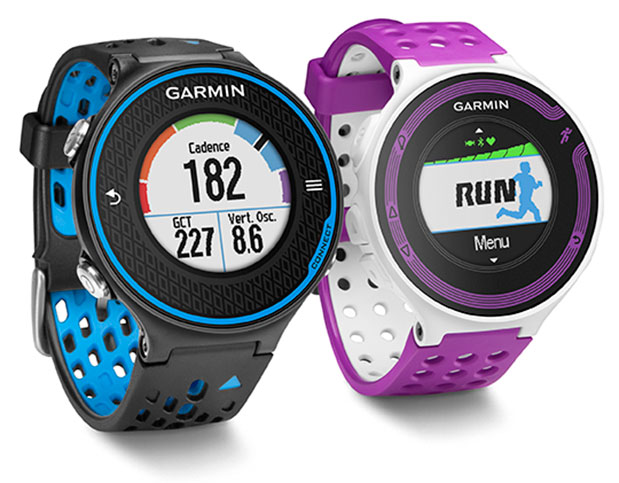
    • Cadence — the number of steps per minute. It displays the total steps (right and left combined)
    • Vertical oscillation — the bounce in runners’ running motion. It displays the vertical motion of a runners’ torso, measured in centimeters.
    • Ground contact time — the amount of time in each step that you spend on the ground while running, measured in milliseconds.

    Thanks to their Bluetooth Smart wireless upload capabilities, Forerunner 620 and 220 can send runners’ run data to the Garmin online community, Garmin Connect, without being connected to a computer. It can transfer the data through the Garmin Connect Mobile app on their compatible smartphone. Additional connected features include live tracking, which allows runners’ friends and fans to follow along and see their stats in real-time. Runners must have their phone paired with their 620 or 220 throughout the run to use the LiveTrack feature. Victories, goals achieved and successes can be shared on runners’ social media sites by posting updates through the Garmin Connect Mobile app.

    With the growing popularity of the run/walk training method in the distance running community (example: a runner runs for five minutes, walks for one minute and repeats for the duration of the course), Garmin has included a run/walk alert. This alert allows Forerunner 620 and 220’s other features, such as, Auto Lap and Auto Pause, to remain active during a run/walk session.

    Both Forerunner 620 and 220 are water-resistant to 50m and can stand up to much more than rain, sweat and splashes. The Forerunner 620 has a touchscreen display responsive enough that it can be operated with running gloves, while the 220 is operated with easy to push buttons. Both models have rechargeable batteries lasting up to six weeks in watch mode and up to 10 hours in training mode.

  • NovAtel Offers Commercial Tactical-Grade MEMS IMU

    NovAtel Offers Commercial Tactical-Grade MEMS IMU

    NovAtel OEM-IMU-STIM300.
    NovAtel OEM-IMU-STIM300.

    NovAtel has added Sensonor’s commercially exportable OEM-IMU-STIM300 to its SPAN GNSS + INS line of positioning products. The OEM-IMU-STIM300 is a Micro Electromechanical System (MEMS) Inertial Measurement Unit (IMU) that integrates with NovAtel’s OEM6 receiver technology to provide a powerful 3D continuous position, velocity and attitude solution, the company said.

    The distinguishing characteristic of the OEM-IMU-STIM300 is its small form factor with tactical-grade performance capabilities. “As an OEM supplier, our customers come to us with a wide range of application demands. The addition of the OEM-IMU-STIM300 to our SPAN portfolio enables us to provide a cost-effective solution for weight and space constrained environments without having to compromise performance in any way,” said Jason Hamilton, NovAtel director of marketing.

    NovAtel’s proprietary MEMS Interface Card (MIC) integrates the OEM-IMU-STIM300 with NovAtel’s OEM6 receiver products for full SPAN navigation capabilities. The product will be available as an integrated single-enclosure SPAN solution (SPAN-IGM-S1), enclosed standalone IMU (IMU-IGM-S1) for use with external SPAN-enabled receivers, and as an OEM component (OEM-IMU-STIM300).

    OEM-IMU-STIM300 is available for delivery in September, followed by SPAN-IGM-S1 and IMU-IGM-S1 in November 2013.


  • Trimble Introduces Ashtech High-Accuracy GNSS Module for System Integrators

    Trimble Introduces Ashtech High-Accuracy GNSS Module for System Integrators

    MB-OneTrimble introduced today the Ashtech MB-One GNSS module. The MB-One delivers highly accurate GNSS-based heading plus pitch or roll in an advanced industry standard form-factor for system integrators.

    The announcement was made today at the AUVSI 2013 Conference and Exhibition.

    Its embedded Z-Blade GNSS technology uses all available GNSS signals equally, without any constellation preference, to deliver fast and stable solutions. The MB-One is designed to add precise positioning and heading in a wide variety of applications such as unmanned, agriculture, marine and military systems.

    “System integrators demand high performance, reliability and support for their positioning solutions,” said Olivier Casabianca, business development manager for the Trimble’s GNSS OEM products. “The MB-One is designed for easy integration and rugged dependability. Users can leverage the module’s Ethernet capability and easy-to-use web browser interface to quickly and cost-effectively develop their products and solutions.”

    The MB-One features an enhanced dual-core GNSS engine with 240 channels capable of tracking a large range of GNSS systems including GPS, GLONASS, Galileo and BeiDou. It uses over-the-air satellite corrections using L-Band hardware to achieve decimeter-level accuracy. The module is capable of receiving and decoding Precise Point Positioning (PPP) to output a highly accurate position solution that removes the need for a local base station.

    The Ashtech MB-One module will be available through the Trimble GNSS OEM international network of representatives and authorized dealers. Evaluation units will be available in the fourth quarter of 2013 and production units are expected to be available in the first quarter of 2014.


  • VectorNav to Supply VN-200 GPS/INS to Troll Systems

    VectorNav to Supply VN-200 GPS/INS to Troll Systems


    Vector Technologies VN-200
    VectorNav Technologies VN-200.

    VectorNav Technologies, a provider of inertial navigation solutions for the industrial and military markets, announced Tuesday that it will supply its VN-200 GPS-aided inertial navigation system (GPS/INS) for use in Troll Systems’ SkyLink MINI II directional antennas. The next-generation version of the SkyLink antenna provides Troll Systems’ customers with a lower-cost and easier to integrate update to its existing SkyLink antenna solution, the company said.

    VectorNav made the announcement at AUVSI’s Unmanned Systems North America 2013 Conference, August 12-15, in Washington, D.C., where both companies are exhibiting.

    About the size of a postage stamp, VectorNav’s VN-200 is a calibrated MEMS-based GPS/INS that provides a coupled position, velocity, and attitude solution suitable for a wide range of static and dynamic operating conditions. The VN-200 incorporates an onboard high sensitivity 50-channel u-blox GPS module. The microprocessor runs an aerospace-grade Kalman filter algorithm at a rate of up to 200 hertz and provides accuracies better than 0.25 degrees in pitch and roll and 0.75 degrees in heading. The upgraded version of Troll Systems’ SkyLink MINI II antenna features a deeply embedded, surface mount VN-200 GPS/INS module that delivers control and stabilization for the gimbaled antenna system.

    The only airborne directional antennas to pass DO-160 testing, Troll Systems’ SkyLink antennas are compact, lightweight and steerable airborne tracking antennas that equip its users with an industry leading air-to-ground data-link solution. The upgraded SkyLink antenna system featuring the VN-200 GPS/INS enables Troll’s customers to eliminate the need for external hardware or GPS input, reducing the cost of installation and the need to certify or calibrate external positioning devices.

    The performance of the VN-200 GPS/INS enabled the upgraded antenna system to maintain the high degree of accuracy required to replace the existing SkyLink navigation system, which was comprised of a Quartz MEMS-based attitude heading reference system (AHRS) and high-end GPS receiver, VectorNav said. Several rounds of ground and air testing and qualification with engineers from both teams demonstrated the capacity of the miniature MEMS-based GPS/INS solution to provide high performance in high dynamic conditions and when subjected to high-frequency vibration. VectorNav worked closely with Troll Systems to implement several features to add to the robustness of the solution, including an embedded magnetic hard and soft iron calibration routine and dynamic start-up routine.

    “We are very pleased to be working with Troll Systems on their SkyLink line of antennas, which represent the gold standard for directional antennas in the industry,” said John Brashear, VectorNav’s President. “We are also proud to demonstrate the capacity of our VN-200 GPS/INS to provide a solution comparable to much higher-end systems and for an application that has very demanding and sophisticated navigation and control requirements.”

  • Spectracom Teams with Geodetics For Rugged PNT Equipment

    Spectracom Teams with Geodetics For Rugged PNT Equipment

    Spectracom announced today a strategic partnership with Geodetics Incorporated of San Diego, California. The partnership includes a variety of initiatives to enhance each company’s customer reach, channels, products and technology.

    The partnership includes a distribution agreement for Geodetics’ Geo-iNAV inertial navigation products. Spectracom will offer Geo-iNAV alongside its portfolio of precision timing, test and simulation equipment. Geo-iNAV is a fully integrated GPS-aided inertial navigation system that provides real-time, high-precision positioning and navigation solutions for manned and unmanned air, sea and ground vehicles. It combines GPS and sensor fusion to achieve centimeter-level real-time positioning and navigation for dynamic platforms.

    “In line with our long heritage in delivering robust precision time and frequency products and services, we understand the challenges our customers face to adopt and adapt new and often disparate GPS and GNSS technologies,” said Spectracom President and CEO, Lisa Withers. “We believe our partnership with Geodetics will help to simplify the integration of complex positioning, navigation and timing technologies and provide our customers with a broad range of GPS and inertial navigation platforms readily suited for today’s dynamic and mobile environments.”

    Geodetics President and CEO Lydia Bock added, “Spectracom’s global reach immediately widens the playing field for our inertial navigation products and technology. They have a keen sense of customer’s needs for the convergence of PNT in both military and commercial applications.”

    As the GNSS eco-system expands to support mission critical applications, so must the prevalence of interoperability and signal fidelity, and ultimately PNT applications must be able to withstand the temporary loss of GPS due to factors such as signal obscuration, Spectracom said. As such, contemporary GNSS signal management solutions must be resilient to various GPS impairments as required of the application. Geo-iNAV delivers this capability through six configurations. It is available in commercial as well as SAASM GPS configurations as well as a choice of IMU depending on accuracy requirements. It offers a low SWaP (size, weight and power) profile for autonomous vehicles and payloads on manned vehicles to meet a wide range of applications.

    As a part of Spectracom’s broader initiative to provide a comprehensive portfolio of GNSS signal management products, systems and services, the Geo-iNAV is the first in a series of compact and rugged solutions specific to PNT applications. In addition to simplifying complexity for its customers with contemporary, modular platforms, Spectracom’s market reach, together with the technical strengths of their partners such as Geodetics will accelerate time to market and aggregate the resources necessary to support unique and changing needs for precision references, simulation and signal test and analysis.

  • NovAtel SPAN-CPT Receiver Supports OEM6 GNSS Platform

    NovAtel’s single-box SPAN-CPT GNSS/INS receiver now supports the company’s next-generation OEM6 GNSS technology platform. The OEM6 GNSS engine significantly improves positioning performance through its support of GPS and GLONASS, all-in-view satellite tracking and intelligent measurement selection, the company said.

    “We kept the design of the enhanced SPAN-CPT identical to our legacy product to ensure a seamless upgrade process for our customers who would like to take advantage of the improved positioning capabilities,” said Jason Hamilton, NovAtel director of marketing. “The enhanced SPAN-CPT is fully backwards compatible with the previous generation of product. It retains the same compact form factor with identical pin-out and log structure.”

    As with the previous generation product, the upgraded SPAN-CPT integrates NovAtel’s precision receiver technology with fiber optic gyro and MEMS accelerometer inertial components from KVH Industries in one compact unit. The tight-coupling of the GNSS and INS technologies optimizes the raw GNSS and IMU data, delivering a superior position, velocity and attitude solution, NovAtel said. Comprised entirely of commercial components, the SPAN-CPT minimizes the operational complexities of working across international boundaries.

    Production of the OEM6 supported SPAN-CPT begins June 1.

  • Advanced Navigation Releases Dual-Antenna GNSS/INS

    Advanced Navigation Releases Dual-Antenna GNSS/INS

    Advanced Navigation has released Spatial Dual, its new dual-antenna GNSS/INS. Spatial Dual is a ruggedized miniature GPS-aided inertial navigation system and AHRS that provides accurate position, velocity, acceleration and orientation under demanding conditions. It combines temperature calibrated accelerometers, gyroscopes, magnetometers and a pressure sensor with a dual-antenna RTK GNSS receiver. These are coupled in a sophisticated fusion algorithm to deliver accurate and reliable navigation and orientation, the company said.

    Spatial Dual contains the Trimble BD982 GNSS receiver, which is a triple frequency dual-antenna RTK GNSS receiver. Using dual-frequency moving baseline RTK, Spatial Dual is able to provide heading accuracy of less than 0.1 degrees using its dual antennas. The dual-antenna heading works while both stationary and moving and allows for very accurate heading in both slow moving and 3D vehicles, where equivalent single antenna systems must rely on magnetic heading. An additional benefit of the dual antennas is the ability to measure slip angle to within 0.2 degrees.

    Spatial Dual supports all of the current and future satellite systems, including GPS, GLONASS, Galileo and BeiDou. In addition, Spatial Dual supports RTK for centimeter positional accuracy and the recent Omnistar G2 network for 10 centimeter accuracy.

    Spatial Dual provides position, velocity and orientation at rates up to 1000 Hz for highly dynamic applications. When Spatial Dual loses a GNSS fix it continues to navigate using dead reckoning inertial navigation to provide seamless navigation data through tunnels and other outage situations.

    Spatial Dual is housed in a precision marine-grade aluminum enclosure that is waterproof and dirtproof to the IP67 standard and shockproof to 2000g, allowing it to be used in tough conditions.

    Spatial Dual supports a wide range of peripherals including odometers and wheel speed sensors for ground vehicle navigation, DVLs and USBLs for underwater navigation and many other external sensors. It supports both industry standard NMEA output and an efficient binary protocol.

  • Riegl and Applanix Take Flight on UAV


    Riegl Laser Measurement Systems and Applanix Corporation announced today that the Applanix AP50 GNSS-inertial sensor system was successfully integrated with Riegl’s VQ-820-GU topo-bathymetric airborne laser scanner on board the Schiebel Camcopter S-100 UAV. The Riegl VQ-820-GU is specifically designed to survey sea beds and the grounds of rivers or lakes, and is well suited for combined land and hydrographic airborne survey.

    ap50
    Applanix AP50 GNSS-inertial system.

    The Applanix AP50 GNSS-inertial system is a GNSS-inertial sensor plus inertial measurement unit (IMU) in a compact form factor. It features a high-performance precision GNSS receiver and the Applanix IN-Fusion GNSS-inertial integration technology running on a powerful, dedicated inertial engine (IE) board.

    On board an unmanned aerial vehicle (UAV), the system is capable of penetrating areas that may be too dangerous for piloted aircraft or ground patrols. This can provide additional safety and security for its users.

    VQ-820-G_206x200px
    Riegl’s VQ-820-G airborne laser scanner.

    “We really appreciate the professional and amicable cooperation with Applanix, which allows us to offer user-friendly and powerful, fully integrated solutions for dynamic data acquisition to the marketplace,” said Jürgen Nussbaum, Riegl director of international sales.

    In addition, Applanix will be a Gold sponsor at Riegl LIDAR 2013, Riegl’s international user conference taking place in Vienna, Austria, June 25-27.

  • Urban GPS Navigation Improved 50-90 Percent, Researchers Say

    A new system developed by Universidad Carlos III de Madrid (UC3M) researchers uses sensors to improve the ability of GPS to determine a vehicle’s position compared to use of conventional GPS devices by up to 90 percent.

    The prototype can guarantee the position of the vehicle to within 1 or 2 meters in urban settings, the researchers said.

    The system can be installed in any vehicle for little cost and may eventually work on smartphones, the researchers said. Their findings are described in the report, “Context-Aided Sensor Fusion for Enhanced Urban Navigation.”

    Sensor Fusion. The prototype system incorporates a conventional GPS signal with those of other sensors (accelerometers and gyroscopes) to reduce the margin of error in establishing a location. “We have managed to improve the determination of a vehicle’s position in critical cases by between 50 and 90 percent, depending on the degree of the signals’ degradation and the time that is affecting the degradation on the GPS receiver,” said David Martín, a researcher at the Systems Intelligence Laboratory (LSI – Laboratorio de Sistemas Inteligentes) at UC3M. The system was jointly designed and developed by LSI and the Applied Artificial Intelligence Group (GIAA – Grupo de Inteligencia Aplicada Artificial).

    The margin of error of a commercial GPS, such as those that are used in cars, is about 15 meters in an open field, where the receiver has wide visibility from the satellites. However, in an urban setting, the determination of a vehicle’s position can be off by more than 50 meters, due to the signals bouncing off of obstacles like buildings, trees, or narrow streets. In certain cases, such as in tunnels, communication is lost, hindering the GPS applications reaching Intelligent Transport Systems, which require a high level of security.

    “Future applications that will benefit from the technology that we are currently working on will include cooperative driving, automatic maneuvers for the safety of pedestrians, autonomous vehicles or cooperative collision warning systems,” the scientists comment.

    Integration of GNSS antenna of rover receiver and IMU in a platform over the roof of the vehicle.
    Integration of GNSS antenna of rover receiver and IMU in a platform over the roof of the vehicle.

    The greatest problem presented by a commercial GPS in an urban setting is the loss of all satellite signals. “This occurs continually, but commercial receivers partially solve the problem by making use of the urban maps that attempt to position the vehicle in an approximate point,” Martín said. “These devices can indicate to the driver approximately where he is, but they cannot be used as a source of information in an Intelligent Transport System like those we have cited.”

    The basic elements that make up this system are a GPS and a low-cost inertial measurement unit (IMU). The latter device integrates three accelerometers and three gyroscopes to measure changes in velocity and maneuvers performed by the vehicle. Then, everything is connected to a computer that has an application that merges the data and corrects the errors in the geographic coordinates. Enrique Martí of UC3M’s GIAA explains, “This software is based on an architecture that uses context information and a powerful algorithm (an unscented Kalman filter) that eliminates the instantaneous deviations caused by the degradation of the signals received by the GPS receiver or the total or partial loss of the satellites.”

    The current prototype can be installed in any type of vehicle. It is already working on board the IVVI (Intelligent Vehicle based on Visual Information, pictured above), a car that has become a platform for research and experimentation for professors and students at the university.

    The LSI and UC3M researchers working on this “intelligent car” can capture and interpret all of the information available on the road, and that drivers use. To do this, the team is using optical cameras, infrareds and lasers to detect whether drivers are crossing the lines on the road, or whether there are pedestrians in the vehicle’s path, as well as to adapt the speed to the traffic signals and analyze the driver’s level of sleepiness in real time.

    Next Steps. The researchers will analyze the possibility of developing a system that makes use of the sensors that are built into smartphones, because intelligent telephones are equipped with more than ten sensors, such as an accelerometer, a gyroscope, a magnetometer, GPS and cameras, in addition to Wi-Fi, Bluetooth or GSM communications.

    “We are now starting to work on the integration of this data fusion system into a mobile telephone,” said Enrique Martí, “so that it can integrate all of the measurements that come from its sensors in order to obtain the same result that we have now, but at an even much lower cost, since it is something that almost everyone can carry around in his pocket.”

  • NovAtel Announces MEMS IMU for Pairing with OEM6 Receivers

    NovAtel Announces MEMS IMU for Pairing with OEM6 Receivers

    NovAtel Inc., supplier of OEM GNSS components and subsystems, has announced the addition of a new commercially exportable MEMS IMU to its line of SPAN GNSS/INS products. Available for immediate shipping, this custom Analogue Devices MEMS inertial sensor is exclusive to NovAtel, and can be paired with an OEM6 receiver card to provide continuously available position, velocity and attitude (roll, pitch, yaw) in a small, single-unit form factor.

    SPAN tightly couples NovAtel’s precise GNSS technology with highly accurate inertial measurement technology to provide a robust, stable and continuous 3D navigation. The new OEM-ADIS-16488 sensor is designed to be coupled with NovAtel’s OEM6 receivers via the MEMS Interface Card (MIC), providing integrators with a  compact, powerful GNSS/INS engine, NovAtel said.

    The OEM-ADIS-16488 features low noise gyros and accelerometers in a small, lightweight form factor.  This IMU enables precision measurements for applications that require low cost, high performance and rugged durability.  Tight-coupling of the two technologies enables continuous robust positioning in difficult environments where satellite signals are unreliable or unavailable for short periods of time.

    The OEM-ADIS-16488 is now available for order and immediate shipment.

  • Advanced Navigation, KVH Release Spatial FOG GNSS/INS

    Advanced Navigation, in collaboration with KVH Industries, has announced its new Spatial FOG GNSS/INS. Spatial FOG is a ruggedized GNSS-aided inertial navigation system and AHRS that provides accurate position, velocity, acceleration and orientation under demanding conditions. It combines the new KVH Industries 1750 fiber-optic gyroscope-based inertial measurement unit with magnetometers, a pressure sensor and a dual-frequency RTK GNSS receiver. These are coupled in a sophisticated fusion algorithm to deliver highly accurate and reliable navigation and orientation, the companies said.

    Spatial FOG contains a dual-frequency RTK GNSS receiver that provides 1-centimeter accuracy positioning and supports all of the current and future satellite navigation systems, including GPS, GLONASS, Galileo and Compass.

    A next-generation memory backup system allows Spatial FOG to hot start inertial navigation from its last position in 2 seconds and obtain a GNSS fix in as little as 3 seconds. The memory backup system lasts for the lifetime of the product and will provide backup for 24 hours without power.

    Spatial FOG’s internal filter runs at 1,000 Hz, and data can also output at this rate over high speed RS232 or RS422. This allows for control of dynamically unstable platforms, the companies said. Spatial FOG is also highly tolerant to both shock and vibration thanks to the performance of the KVH 1750 IMU design and advanced filtering.

    Spatial FOG supports a wide range of peripherals including external GNSS receivers, odometers, DVLs, USBLs and NMEA devices. It also supports both industry-standard NMEA output and a binary protocol. Spatial FOG also is easily integrated into retrofits or new designs, said Advanced Navigation.

  • Trimble Launches AP20-C GNSS Inertial OEM Module with MEMS Inertial Sensors

    Trimble AP series module

    Trimble has introduced the AP20-C, the latest addition to its AP Series of embedded GNSS-Inertial OEM boards plus Inertial Measurement Unit (IMU). Using a compact, custom-built IMU based on commercial Micro Electromechanical Machined (MEMS) inertial sensors, the AP20-C enables system integrators to achieve high-rate position and orientation measurements with exceptional accuracy, Trimble said.

    The announcement was made at AUVSI’s Unmanned Systems North America 2012 Conference and Exhibition being held this week in Las Vegas.

    Featuring proven Applanix IN-Fusion GNSS-Inertial integration technology, the AP20-C is an embedded GNSS-Inertial OEM board set plus IMU designed for continuous mobile positioning in poor signal environments and high-accuracy direct georeferencing of imaging sensors. The AP20-C delivers full, high-rate position and orientation measurements at 200 Hz, ensuring it can be used in the most demanding mobile environments without sacrificing performance. It is fully compatible with the industry-leading Applanix POSPac MMS office software for enhanced accuracy using network differential GNSS.

    “Compact in form and low in power consumption, the AP20-C can provide cost-effective, accurate, reliable and robust position and orientation measurements suitable for a broad range of survey and mapping applications, including airborne, terrestrial, and marine mapping as well as guidance for unmanned vehicle applications,” said Joe Hutton, director of Inertial Technology and Airborne Products at Applanix, a Trimble Company.