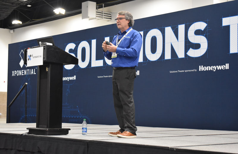
Attendees crowded the show floor during the first day of AUVSI XPONENTIAL 2023.
AUVSI XPONENTIAL is underway in Denver, Colorado, at the Colorado Convention Center. After the first day of touring the XPO Hall of more than 600 exhibits and attending educational sessions lead by industry leaders and speakers, GPS World staff noticed a key theme: mitigating GNSS jamming and spoofing by advancing technology for UAVs.
Educational Sessions
Franck Boynton, Vice President of NavTachGPS, highlighted Tallysman ‘s HC871SXF during his “Real World GPS/GNSS Protection from Start to Finish,” presentation.
“Real World GPS/GNSS Protection from Start to Finish,” was presented by Franck Boynton, Vice President of NavTechGPS. He discussed why anti-jam equipment is needed and how to mitigate jamming. Boynton mentioned several anti-jam products, such as NovAtel’s OEM series product line, Septentrio’s AIM+, Tallysman’s HC871SXF and more.
Additionally, GPS World contributing writer, Dana Goward, received a mention for his article regarding the GPS jamming incident on Jan 21, 2022, at Denver International Airport, which can be found here. Boynton also suggested checking out the RNT Foundation, which is a nonprofit, public benefit corporation that helps protect critical infrastructure by promoting resilient navigation and timing, of which Goward is the president and director.
“The Importance of GNSS Security in UAV Applications,” featured a panel of speakers that included (from left to right) Captain Joe Burns, CEO of the Airo Group and member of the National Space-Based Positioning, Navigation and Timing Advisory Board, Jeff Horne, vice president of security at Skydio Abigail Smith, executive director of UAS security at the FAA, Gustavo Lopez, market access manager at Septentrio, and moderated by Michael Glutting, sales manager at Septentrio.
“The Importance of GNSS Security in UAV Applications,” featured a panel of speakers that included Abigail Smith, executive director of UAS security at the FAA, Captain Joe Burns, CEO of the Airo Group and member of the National Space-Based Positioning, Navigation and Timing Advisory Board, Gustavo Lopez, market access manager at Septentrio, Jeff Horne, vice president of security at Skydio, and moderated by Michael Glutting, sales manager at Septentrio. During the panel discussion, the speakers explained types of GPS interference, including jamming and spoofing, and the risk they pose to UAVs. The latest methods for strengthening both GNSS receivers and control units to design secure and robust UAVs was also discussed.
Day-of highlights
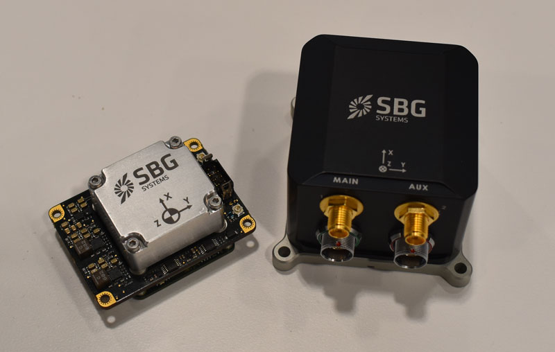
Maddie Saines, managing editor, and Jesse Khalil, digital media specialist, had the opportunity to stop by several booths in the XPO Hall on the first day of XPONENTIAL. A few highlights from the day included speaking with Ahmet Salih Erdem, deputy general manager at Tualcom, getting an in-depth look at SBG Systems’ Quanta Mirco and Ekinox Micro with Yoann Plenet, head of product management, and getting a first-hand look into the newest products from Tallysman Wireless — such as SSL889XF — from Ken MacLeod, product manager for Tallysman.
SBG System’s Quanta Mirco and Ekinox Micro.Ken MacLeod, product manager for Tallysman, showcasing the AJ977XF.Tualcom’s booth at XPONENTIAL 2023 showcased new products such as ANTY, its GPS anti-jamming device.
Septentrio has signed a distribution partnership with Braemac for North America and Mexico. Braemac will distribute the full Septentrio portfolio including the compact mosaic module family, OEM boards, GNSS enclosures and GNSS/INS solutions for demanding industrial applications.
Braemac distributes electronic components in the North American market and offers GNSS antennas, wireless connectivity solutions and other products, which are complementary to the Septentrio portfolio.
Septentrio’s advanced GNSS chipset and proprietary algorithms provide consistent pinpoint accuracy for its receivers. The built-in advanced interference mitigation technology ensures resilience to GNSS jamming and spoofing, making Septentrio’s GNSS and GNSS/INS receivers a suitable positioning component in any robotic, UAV or machine control system.
Septentrio will be exhibiting at the AUVSI XPONENTIAL conference in Denver, Colorado, on May 9 -11 at booth 4912. On Tuesday May 9, GNSS experts from Septentrio as well as other UAV integrators will share their experience in the panel discussion about “The Importance of GNSS Security in UAV Applications”.
The Trektor hybrid robot for agriculture, made by the French company SITIA, can work on a variety of crops by changing the width of its wheelbase and can perform many repetitive tasks, such as spraying and hoeing. (Image: SITIA)
Precision agriculture has been around for more than 30 years and now covers the majority of U.S. farmland. It refers to the ability of farmers to observe, measure and respond precisely to the variability of soil and crop characteristics within and between fields by using maps of these characteristics and GNSS navigation. It enables them to reduce inputs of seed, water, fertilizer, pesticides and fuel while increasing outputs. It also enables them to work at night and in the fog and automate many functions at large feed lots.
For precision agriculture, GNSS integrity can mean the difference between, say, a robot protecting a vineyard by weeding and spraying pesticides or damaging it by straying onto the vines.
Autonomous Tractors, Mowers, and Feed Monitors
SITIA, a French company, has developed an autonomous tractor that is used by, among others, an organic vineyard in France’s Loire valley to tirelessly weed the narrow rows between the grape vines — compensating for the movement of young workers to cities. Thanks to the high accuracy and integrity of the Septentrio GNSS heading receiver inside, the autonomous tractor has decreased the damage to the vineyards by more than an order of magnitude compared to the traditional work done by a farmer with a manual tractor.
Renu Robotics, based in San Antonio, Texas, makes a robot for vegetation management, called Renubot. It uses machine learning, a form of artificial intelligence, to plan its route, optimize its energy consumption, perform self-diagnostics, collect environmental data and assess the topography that it traverses.
Navigation is based on a stored map of paths, a Septentrio RTK GPS receiver and sensors to avoid obstacles. A radio link enables the Renubot to communicate with a control center, for reporting and updates. When the Renubot returns to its recharge pod, it charges its lithium battery and performs updates and downloads.
Manabotix Pty. Ltd., an Australian company, has developed an automated system to monitor cattle in large feedlots, using GNSS, lidar scanning and other vision or perception technologies and artificial intelligence. This has greatly improved the accuracy and consistency of feedlot volume estimates, which for the previous 150 years had been the responsibility of a select few employees, who would visually gauge the amount of feed in concrete troughs. This visual inspection by humans was inherently imprecise, subjective, and inconsistent, often causing animals to eat too much or too little one day and get off their optimal growth curve or even become ill. Manabotix’s solution consists of a Septentrio AsteRx-U GNSS receiver and antenna, a lidar scanner, and an onboard processing platform.
Statistical Analysis
Integrity is a key aspect of all these applications. A part of delivering integrity is a statistical analysis called receiver autonomous integrity monitoring (RAIM), which was developed for such safety-critical applications as aviation or marine navigation. A refinement of RAIM, called RAIM+, takes this analysis to the next level as part of a larger positioning protection package.
For autonomous operation, it can be particularly hazardous to be overly optimistic about GNSS accuracy. This parameter is reported in the form of positioning uncertainty, which is the maximum possible error on the calculated position. It is especially necessary in challenging GNSS environments, where the receiver has a direct line of sight to only a limited number of GNSS satellites or where GNSS signals are degraded. RAIM alerts users when their receiver’s uncertainty strays beyond the limits they have chosen for their application.
Users can be deceived by a consistent position or movement — which can be consistently inaccurate. The positioning uncertainty gives them an indication of the extent to which they can rely on their receiver’s positioning accuracy at any given moment. The receiver operator can set an alarm limit, so that the receiver can flag situations when positioning uncertainty becomes too large.
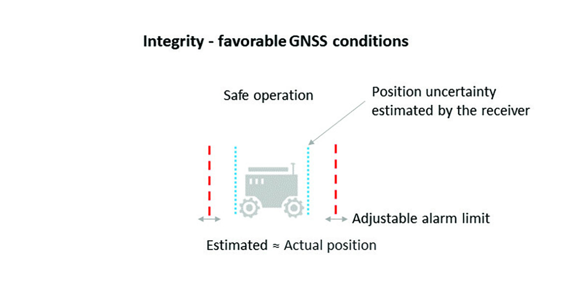
The blue line in Figure 1 shows position uncertainty estimated by a GNSS receiver under favorable conditions, when the view of the sky is unobstructed, and the receiver has a direct line-of-sight to many satellites.
Figure 1. Under good GNSS conditions, the position uncertainty shown by the blue lines is well within the alarm limits, indicating safe operation. The actual position of the receiver should always remain within the blue uncertainty boundaries. (Image: Septentrio)
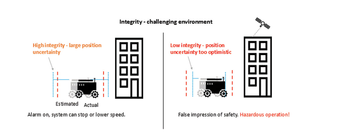
During favorable conditions, the positioning uncertainty stays well below the alarm limit because the calculated position is almost the same as the robot’s actual position. However, in challenging environments, the truthfulness of positioning uncertainty becomes most critical (see Figure 2).
Figure 2. In challenging environments receivers with high integrity report large positioning uncertainty, flagging possible inaccuracies to the system. If the receiver is too optimistic about its accuracy, the operation becomes hazardous. (Image: Septentrio)
For instance, when the view of the sky is partially obstructed by buildings or foliage, the receiver has access to only a limited number of GNSS satellites, making it harder to calculate accurate position. In such cases the receiver must report a higher positioning uncertainty, so that the system can take adequate action such as switching to lower speeds, staying further away from predefined boundaries, or stopping.
A low integrity receiver may keep reporting an optimistic positioning uncertainty, that stays below the preset alarm limit even when the calculated position is way off from the actual position. The number may look fine, but effectively it becomes a “robot on the loose,” no longer on its planned path with a risk of damaging itself and its surroundings.
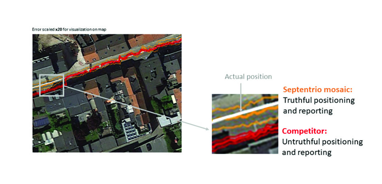
Let us look at uncertainty limits in action during a GNSS car test in an urban canyon, where the view of the sky is partially obstructed by houses (see Figure 3). The orange lines are the positioning and its uncertainty boundaries reported by a Septentrio mosaic GNSS module in the car, while the red lines are the positioning and its uncertainty boundaries reported by another popular GNSS receiver. The white line shows the actual position of the car as it drives along the road. The orange uncertainty boundaries of the mosaic receiver are truthful and somewhat wider in this challenging environment, and you can see that the actual position always remains within these boundaries. On the other hand, the red trajectory jumps off course in a certain challenging spot on the road, with the actual position no more within the uncertainty boundaries, which remain too optimistic. In this case the competitor’s receiver gives a false sense of security and the system is unaware of its hazardous operation.
Figure 3. In an urban canyon car test the Septentrio receiver reports truthful position uncertainty. A competitor receiver seems to be more accurate, while the actual position is not even within its reported uncertainty boundaries. (Image: Septentrio)
If the receiver depicted by the red line provided navigational information for an ADAS automotive system, for example, this could mislead the system into thinking that the car switched lanes. If the system then attempted to correct the trajectory by switching back to the “correct lane” this would result in taking the car off course and potentially hitting the sidewalk or even another car.
RAIM vs RAIM+
The underlying mechanism behind truthful positioning uncertainty reporting is RAIM, which ensures a truthful positioning calculation based on statistical analysis and exclusion of any outlier satellites or signals. Septentrio receivers are designed for high integrity and take RAIM to the next level with RAIM+, guaranteeing truthfulness of positioning with a high degree of confidence.
In Septentrio receivers RAIM+ is a component of a larger receiver protection suite called GNSS+ comprising positioning protection on various levels including AIM+ anti-jamming and anti-spoofing, IONO+ resilience to ionospheric scintillations, and APME+ multipath mitigation.
Septentrio has fine-tuned its RAIM+ statistical model with more than 50 terabytes of field data collected over 20 years. It removes satellites and signals which may give errors due to multipath reflection, solar ionospheric activity, jamming and spoofing, while working together with the GNSS+ components mentioned above. Because of this multi-component protection architecture, it achieves a very high level of positioning accuracy and reliability which goes well beyond the standard RAIM. The RAIM+ statistical model is adaptive, highly detailed, and complete, taking advantage of all available GNSS constellations and signals. The full RAIM+ functionality is also available in Septentrio’s GNSS/INS receiver line. User controlled parameters allow it to be tuned to specific requirements.
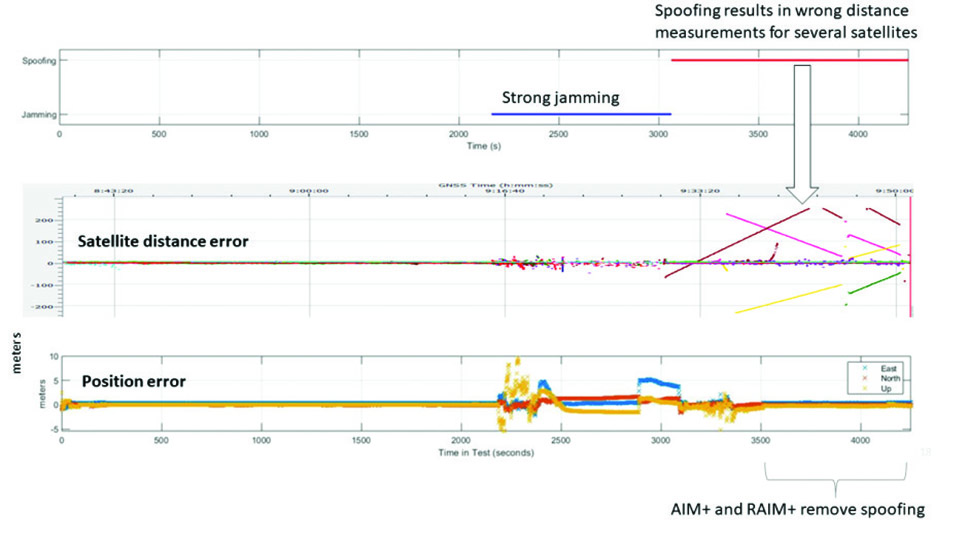
The diagram in Figure 4 shows RAIM+ in action during a jamming and spoofing attack on a Septentrio GNSS receiver. While AIM+ removes the effects of GNSS jamming, both AIM+ and RAIM+ work together to block the spoofing attack. Satellites with high distance errors, shown on the middle graph, are removed by RAIM+ since they do not conform to the expected satellite distance.
Figure 4. In this scenario jamming gives satellite distance errors but is countered by AIM+ technology. During spoofing AIM+ eliminates some of the spoofed satellites, while other satellites that have wrong distances are dismissed by RAIM+ algorithms. (Image: Septentrio)
This example shows that even in the case of jamming and spoofing, Septentrio’s high integrity receiver technology delivers truthful and reliable positioning on which any autonomous system can count.
GNSS Design Around Reliability
GNSS receivers designed to be reliable strive for high integrity in both reporting of the positioning uncertainty as well as in RAIM+ advanced statistical modelling. This ensures that these receivers provide truthful and timely warning messages and are resilient in various challenging environments. Other technologies such as inertial navigation system (INS) can also be coupled to the GNSS receiver to extend positioning availability even during short GNSS outages. Quality indicators for satellite signals, CPU status, base-station quality and overall quality allow monitoring of positioning reliability at any given time. High-integrity GNSS receivers provide truthful positioning in autonomous machines such as the SITIA weeding tractor. They are also crucial components in safety-critical applications, assured PNT and any other application where accuracy and reliability matters.
Septentrio, a leader in high-precision GNSS positioning solutions, has launched the Agnostic Corrections Partner Program.
The program facilitates the use of Septentrio receivers with high-accuracy services that provide varying levels of accuracy, coverage and delivery methods. This also allows users to select the service that suits specific applications and business models.
The Agnostic Correction Partner Program, which includes Polaris from Point One, Skylark from Swift Navigation, and PointPerfect from u-blox, provides documentation for the use of Septentrio receivers with these high-accuracy services.
Agnostic GNSS corrections refer to correction services that are not specific to a particular GNSS receiver or device. It provides correction data that can be used by any receiver that can process the correction signal. Agnostic corrections are useful in situations where multiple types of GNSS receivers are being used, such as in a large-scale surveying project or in a fleet of vehicles that use different types of navigation systems.
As drones are becoming a popular mode of delivery, surveillance, inspection, and mapping, they need to be resilient to spoofing. On Dec. 15, Septentrio hosted a webinar about detecting, mitigating, and protecting against spoofing on UAV autopilots.
Topics discussed included how GPS/GNSS technology fit into the autopilot ecosystem, signs of GPS spoofing and UAV vulnerabilities, realistic demonstrations of spoofing, how to mitigate spoofing, and autopilot compatibility with resilient GPS modules.
Wim De Wilde, R&D Team Leader at Septentrio, facilitated a presentation on vulnerabilities of UAVs. It included detecting signal anomalies and inconsistencies in GPS receivers to flag spoofing, technology used to spoof or hijack drones, and recommendations to prepare autopilots before take-off.
The next presentation, by Ramon Roche, General Manager at DroneCode Foundation and PX4 Autopilot, explained PX4 products that have built-in resilient GPS receivers. Greg Lopes, Hardware Design Engineer at Zipline, further elaborated about the importance of having robust, resilient GPS receivers to mitigate spoofing as it relates to Zipline’s delivery drones.
Figure 1
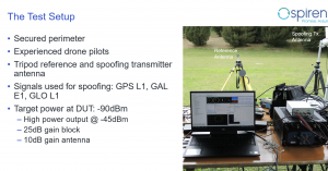
One of the final presentations was a case study of an in-field simulation and spoofing test by Jack Ackermann, Director of Product Line Management at Spirent. The case study preparation and test results that were discussed in the webinar can be seen in Figures 1 and 2.
Septentrio holds frequent webinars, with knowledgeable guest speakers, regarding topics related to GPS/GNSS technology. Find previous webinars and learn about upcoming ones here.
Septentrio’s mosaic-T is built specifically for resilient and precise time and frequency synchronization under challenging conditions. (Photo: Septentrio)
Fugro has signed a tri-party cooperation agreement with GNSS receiver company Septentrio and synchronization equipment manufacturer Meinberg to launch the Fugro AtomiChron real-time synchronization and authentication service.
Numerous sectors rely on resilient and highly accurate time synchronization, including telecommunications, finance and energy. The timing technology eliminates time drift caused by clocks counting time at slightly different rates, and provides extreme stability that surpasses current precision frequency standards.
With up to sub-nanosecond accuracy, Fugro AtomiChron includes Navigation Message Authentication (NMA), ensuring reception of genuine GNSS signals and time synchronization improvements. Integrated anti-spoofing detection further prevents interference with GNSS timing signals providing accuracy, authentication, validity and security for end users.
The agreement ensures that the Fugro AtomiChron service will be available in new Septentrio mosaic-T GNSS receivers, as well as a selection of Meinberg GNSS clocks, without the need for additional physical interfaces or separate antennas.
“Septentrio is a forerunner in the area of robust and resilient GNSS solutions,” said Jan Van Hees, business development director at Septentrio. “With the addition of the unique Fugro AtomiChron service, we are pleased to further strengthen our offering and provide our customers even more accurate and reliable solutions for resilient GNSS timing.”
Septentrio, a leader in high-precision GNSS positioning solutions, introduced the AsteRx SB3 ProBase, the latest generation of GPS/GNSS base station receivers, designed for the creation of top-quality measurements for RTK and differential corrections.
The AsteRx SB3 ProBase is an IP68-housed GNSS base station receiver, featuring the latest quad-constellation GNSS technology for the best quality measurements. The new ruggedized receiver complements the SB3 receiver family: the AsteRx SB3 Pro, rover receiver, the AsteRx SB3 Pro+ rover and base receiver and the AsteRx SB3 CLAS, dedicated to the Japanese market.
“Customers often look for a simple, high-quality and easy-to-integrate base station to set up local high precision RTK or to densify their network and the AsteRx SB3 ProBase is the perfect solution,” said Silviu Taujan, Product Manager at Septentrio. “Thanks to its configuration flexibility and monitoring capabilities it is extremely easy to deploy and configure the SB3 ProBase. Plus, it comes with our industry-leading GNSS+ technologies, including anti-jam and anti-spoofing technology (AIM+) for unbeatable robustness and reliability.”
AsteRx SB3 products are pin-to-pin compatible with Septentrio’s popular AsteRx SB ProDirect receiver and with the recently released AsteRx SBi3 GNSS/INS system, making it simple to change receivers.
GNSS receivers face the same old challenges (extremely weak received signal, orbit and satellite clock errors, ionospheric and tropospheric delays, multipath, dilution of precision, urban canyons, etc.) and new ones (increased interference). However, compared with just a few years ago, they benefit from new signals, many more satellites, a panoply of options for corrections, and improved integration with inertial navigation systems (INS).
For example, pole-tilt compensation is quickly becoming standard. This feature enables users to locate dangerous or hard-to-reach points by measuring them at an angle with just the tip of the pole to which the receiver is attached.
Pole-tilt compensation also makes surveying and mapping easier by removing, in many situations, the need to use total stations or offsets. Together with improvements in work processes, this makes GNSS receivers more user friendly. This is particularly welcome now that more surveyors are retiring than there are new surveyors entering the profession.
The greater accuracy of GNSS receivers enabled by the increase in the number and quality of satellites, signals, corrections services and integration of GNSS with other sensors is also increasing the number of use cases, especially at the high end of the accuracy requirements, such as lane-level vehicle navigation. (Next month’s cover story will center on this year’s Google Smartphone Decimeter Challenge contest, in which competing teams aim to bring smartphone location down to the decimeter or even centimeter resolution using raw location measurements from Android smartphones. This could enable services that require lane-level accuracy, such as estimated time of arrival when using a high-occupancy vehicle lane.)
This month’s cover story highlights what has changed “inside the box” to improve the accuracy and resilience of GNSS receivers for surveying, mapping and a variety of other applications. Read the success stories from five different companies below.
Receiver maker Septentrio, based in Leuven, Belgium, has made a series of announcements this year that push the industry forward, from updating existing receivers to accepting new services to launching new product lines.
Head of the CLAS
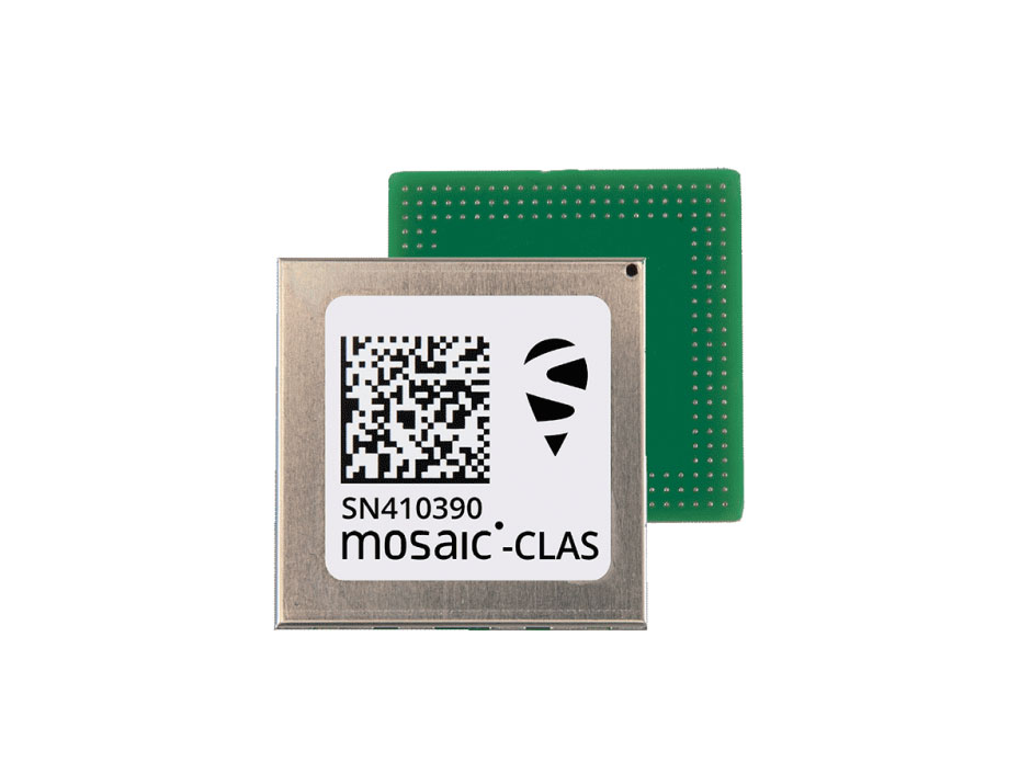
In March, the company launched three new products that support Japan’s high-accuracy Centimeter Level Augmentation Service (CLAS). CLAS, which receives the L6 signal, transmits high-accuracy corrections from Japan’s QZSS constellation. The technology was developed in close cooperation with CORE, a leading integrator of high-accuracy positioning technology and services in Japan.
Photo: Septentrio
Septentrio now offers the mosaic-CLAS receiver for high-volume industrial applications; the AsteRx-m3 CLAS that combines PPP-RTK CLAS with dual-antenna heading functionality; and the AsteRx SB3 CLAS in a ruggedized IP68 enclosure to protect it in harsh environments.
Septentrio is simultaneously offering various receiver types to the Japanese market ensuring an optimal match between products and customer needs in various applications including robotics, precision agriculture, construction, machine control and UAV.
Stopping the Spoofs
Following the CLAS upgrade, the mosaic line received another boost in April, when Septentrio announced Open Service Navigation Message Authentication (OSNMA) functionality. OSNMA offers end-to-end authentication on Galileo’s civilian signals, protecting receivers from OSNMA attacks.
For the past two years, Septentrio has been working closely with the European Space Agency (ESA) during the test phases of OSNMA deployment. The know-how gained during this period allowed Septentrio to be one of the first to market with this advanced security feature.
OSNMA’s anti-spoofing capability complements Septentrio’s Advanced Interference Mitigation (AIM+) technology and further strengthens the overall security of Septentrio GNSS receivers, making them suitable for assured PNT solutions as well as critical infrastructure, such as 5G network synchronization.
Vertical Markets
Machine Control. In April, Septentrio launched the AsteRx-U3 ruggedized GNSS receiver, successor to the AsteRx-U for construction, mining and other machine control applications. The new receiver combines Septentrio’s latest triple-band precise positioning GNSS core with extended wireless communication features including Wi-Fi, UHF and 4G LTE. The versatile connectivity features of this receiver make it easy to fit it into any control system and enable simple and cost-effective overall design.
Photo: Septentrio
Unmanned Aerial Vehicles (UAVs). Also in April, Septentrio is collaborating with MicroPilot, maker of professional UAV autopilots. Septentrio receivers, including the small form factor mosaic modules, as well as the OEM board AsteRx-m3, will support seamless integration of positioning and orientation into MicroPilot’s autopilot ecosystem. MicroPilot chose Septentrio GNSS receivers for their resilience to radio interference such as jamming and spoofing, as well as security and robustness with high-accuracy real-time kinematic (RTK) positioning.
Marine. In May, Septentrio introduced the housed AsteRx-U3 Marine and the OEM board AsteRx-m3 Fg, two receivers for dredging, marine construction and offshore applications. Both offer accurate positioning near shore and offshore via centimeter-level real-time kinematic (RTK) or the built-in Fugro precise point positioning (PPP) sub-decimeter subscription service, delivered either over NTRIP internet or over L-band satellite.
Corrections delivered over L-band allow dredging, bathymetry or marine construction projects even in areas where there is no internet service. The AsteRx-U3 Marine receiver, enclosed in an IP68-rated housing, offers a dedicated L-band demodulator with a separate L-band RF input, which allows for the use of dedicated antennas for excellent reception of L-band signals even at high latitudes.
The average age of surveyors in the United States is nearly that of retirement. Can new technology attract a new generation to the profession?
“We do not fully understand the trend in the United States,” said Simon Peng, ComNav Technology, “but in China we find that modern survey technology — such as UAV/lidar mapping and total stations — make field work simple. New trends such as computer imaging, point clouds and building information models (BIM) attract young surveying engineers.”
Using the equipment in the field is becoming increasingly easier, said Bernhard Richter, Leica Geosystems. “Our goal is that operating the field equipment should not be more difficult than playing with your smartphone. That means that you don’t need the super expert in the field so much anymore.” However, he argued, “someone who studied surveying should now be more the data manager, have the expertise to put the data in geospatial relation, and know in which reference frame he is operating.”
For example, that person needs to know about orthometric and ellipsoidal heights, especially for engineering projects between countries that might have different height codes. “Anybody who has an interest to geolocate an object can capture the data and upload it to the cloud environment,” Richter said. “Then there are the data managers. Certainly, they need to know the physical limits of surveying technology, and they need to manage the complexity of modeling Earth. They need to become data managers to really put data to work.”
“The anticipated number of new professionals is not necessarily replacing all the surveyors who are expected to retire over the next 10 years,” said Boris Skopljak, Trimble. To tackle this challenge Trimble is using a two-pronged approach: attracting younger workers by raising awareness of surveying as a future career and modernization of the profession. For the first prong, Skopljak cited “phenomenal programs out there, such as Get Kids into Survey.” He pointed out that many Trimble employees are part of those education programs, “promoting inclusion of not just a younger generation, but also of women and minority groups that are heavily underrepresented in our industry today.”
For the second prong, “Digital data capture workflows present opportunities. A very common interview question we ask these days is ‘Do you play video games?’ Generally, those young professionals who are gamers thrive in the 3D environment. The technology aligns well with the interests of younger folks.”
Additionally, a growing number of educational institutions are evolving their curriculums to meet these needs, said Skopljak. Trimble is establishing Trimble Technology Labs in selected academic institutions around the world that are helping students access the latest technology and the best modern engineering practices. Boosting productivity also helps compensate for the declining number of surveyors, because it reduces the number of people needed to get the job done. “As the technology becomes easier to digest and operate and more focused on the workflows, it also becomes easier for companies to standardize it and attract talent,” Skopljak said.
One of the biggest threats to the survey profession, according to Huff, is that it “let bits and pieces of traditional surveys fall off to the wayside.” Geographic information systems (GIS) use the same positioning technology, he pointed out. “Fifty years ago, that was more of a function of the surveyor than it was necessarily the GIS profession. In many ways, while the surveyor is aging — the licensed cadastral surveyors certainly are aging — there is a new generation of folks coming through who are leveraging the new technology, such as drones and mobile mapping systems.”
This new generation, Huff argued, will achieve the same accuracies as the previous one partly because it’s getting easier to do so. “We definitely have more of a generation of digital users that can leverage the technology to do things where even my mentors performed many calculations by hand, on the fly, from plain tables in their logbooks with sine, cosine and tangent in them. Now, I think that technology and 3D immersive technology, which hinges on GPS location, attracts a younger crowd to certain facets of the profession.”
François Freulon, Septentrio, agreed that new technologies now available “can be easily adopted by new generations in the profession,” yet added that “quality surveying requires a good formation and experience in the field.” Therefore, he argued, “surveying education systems will need to adapt their programs and incorporate newer techniques such as new positioning modes and corrections.
Surely RTK remains as the main accuracy technique, but this could change quickly in the coming years as correction services bring better performance and regional coverage.”
Land surveying is an ancient practice, dating back at least 5,000 years to when Egyptian rulers used it to tax land plots. Over the centuries, it has been repeatedly transformed by new technologies — the compass (about 200 B.C), the theodolite (1550s), Gunter’s chain (1620), the sextant (1757), electronic distance measurement (1950s), and total stations (1970s). Then came GPS, followed by the other GNSS and corrections services.
Now comes sensor fusion, which aims to compensate for the limitations of GNSS — orbit and satellite clock errors, ionospheric and tropospheric delays, multipath, dilution of precision, urban canyons, jamming, extremely weak received signal, etc. — by integrating it with other sources of positioning data, including inertial measurement units (IMUs), lidar sensors and cameras. Even crowdsourced geolocation data collected with cell phones help expedite surveys by guiding surveyors to landmarks.
In the following article, representatives of five companies share their perspectives on recent advances in surveying and the remaining challenges.
Many More Satellites
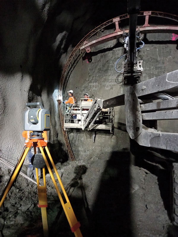
City Rail Link is New Zealand’s first underground rail network and the largest transportation project ever undertaken there. In this photo, taken at Karangahape Station, the Mined Tunnel Team installs a lattice girder secondary support structure using a Trimble SX12. (Photo: Link Alliance)
Compared to just a few years ago, there are many more GNSS satellites, signals and options for correction services. Over the past decade, the average number of satellites in view has more than doubled to more than 40 today. Some parts of the world have more than 70 satellites in view, said Boris Skopljak, vice president, Surveying & Mapping Strategy and Product Marketing at Trimble Inc.
“The developments in GNSS field systems have always been geared toward simplifying workflows, improving accuracies and increasing productivity,” Skopljak said. “In the last few years, we’ve seen that on a massive scale. In some of our materials, we no longer even quote how many signals our GNSS receivers are tracking.”
The vast increase in the number of satellites has extended high-precision applications to the robotics and automotive markets. The challenge now is “position solution,” not just GNSS, said Simon Peng, director of the Overseas Department at ComNav Technology. The improvements in the satellite constellations, antenna technologies and algorithms also enable surveyors and other users to obtain results faster and to operate in environments previously impervious to GNSS, such as under heavy canopy and very close to buildings.
“Our customers can now operate in environments where there is no virtual reference station (VRS) infrastructure or real-time kinematic (RTK), by leveraging precise point positioning (PPP) solutions, such as the Trimble RTX corrections service,” Skopljak said.
“Additional satellite signals and constellations (like Beidou),” Skopljak said, “improved antenna technology and continuously evolving algorithms are contributing to improving the RTX accuracy while bringing the convergence times to almost instantaneous in normal conditions and making technology available in more regions.”
“When I first started surveying, if we had a 12-channel receiver, that was doing very well,” recalled Jesse Huff, head of Sales and Marketing, JAVAD GNSS. “Now, we’re tracking 36 birds in the sky at one time with an 874-channel receiver. That’s phenomenal.”
Huff described a patent-pending feature called real-time post-processed kinematic (RTPK). “It combines RTK, PPK and PP techniques, with multiple core processing engines and a single solution coming out of that. It is impressive standing underneath a giant oak tree and surveying that monument with GPS and knowing what your accuracies are. We’re not even chasing RMS values; we can report the actual positional uncertainties, which is amazing.”
Pole tilt compensation enables surveyors to precisely and easily localize points that are difficult or dangerous to access. (Photo: ComNav Technology Ltd.)
“With so many signals and the new ways of how we compute positions based on PPP technology, we can almost globally get to centimeter-level positioning within a couple of minutes from just one global correction link,” said Bernhard Richter, vice president of Geomatics at Leica Geosystems AG, part of Hexagon. “Under optimum conditions, you can have almost an instantaneous global accuracy of a couple of centimeters.” In mature areas, he added, a local RTK network infrastructure enables achieving centimeter accuracy within a couple of seconds.
Galileo, Richter pointed out, will be fully operational in 2023 with great signals, though he’s “a bit skeptical” about the system’s target date for its high-accuracy service. “So, we will basically get global constellation corrections that allow us also centimeter-level positioning.” BeiDou has been fully operational since 2020. “GLONASS is more unpredictable,” Richter said. “It looks like modernization is slowing down a bit, in particular the CDMA developments.” Additionally, he pointed out, it is possible that one or more governments may decide not to use those signals, for military or political reasons. “It’s not the manufacturers who decide which signals to take.”
“In open-sky conditions, additional satellites have added redundancy — which is always good for position integrity — but it’s only when obstacles start to appear on the horizon, blocking out parts of the sky, that all-in-view RTK really comes into its own,” said François Freulon, Head of Product Management at Septentrio. When they did not have a full view of the sky, he recalled, GNSS users used to have to carefully schedule their work to coincide with times of high satellite visibility. “Nowadays, by using multiple constellations and signals, RTK can reach the parts that receivers in the past could not tread. More signals and constellations have also helped in easing the collection workflow for surveyors, making the capture of data in difficult conditions much quicker and more efficient.” New correction services are further simplifying the workflow “thanks to new positioning techniques, pricing business models and simplified network density.” However, corrections companies still face challenges in ensuring that centimeter accuracy can be uniformly achievable at a global scale.
Sensor Fusion
The ongoing evolution in computing power and communication technology “leads to many more sensor combinations,” Skopljak said. “We are not talking about GNSS alone anymore. We are talking about integrating a GNSS antenna, a receiver, an IMU, power and communications into a single compact housing.” The integration of inertial sensors makes it possible to localize the instrument rod tip when the pole instrument is tilted. “That allows our customers to measure more safely in dangerous environments.”
“We are reaching a maturity stage of what we can do only with GNSS,” said Richter. “It’s all about sensor fusion. The problem when signals are obstructed, that’s not solved, even though we can do positioning from Wi-Fi hotspots or from local pseudolites.” So, fusing data from cameras, lidar, GNSS and IMUs in better ways is the way to go and presents “a huge open research ground.”
For Richter, the challenge is not just positioning, the orientation of objects is almost as important as that, especially for such tasks as machine control. “It’s also about what you do with the data that you collect. Hexagon’s vision is of an autonomous future where we put data to work in connected ecosystems to boost efficiency.” However, he pointed out, this requires large amounts of data, such as those from aerial photogrammetry, lidar and mobile mapping systems used to create city models and digital twins of buildings. “If you really want a car to drive autonomously through a city with all the things that could happen, you must rely on a perfect replication of the real world,” he said. Other examples he cited are more efficient evacuation plans and flooding simulations. “GNSS will never be enough, but it will always be a very good enabler because it works.”
Classes of Receivers
JAVAD GNSS designed its TRIUMPH-LS Plus receiver to work under heavy tree canopy. (Photo: JAVAD GNSS)
Two decades ago, we would often group GNSS receivers by accuracy into three buckets: consumer grade, resource or mapping grade, and survey grade. As accuracy has increased for all GNSS receivers, the boundaries between those categories — especially between mapping and surveying — have blurred. “The performance of GNSS has increased so much that we are not using the traditional accuracy-based differentiation between surveying and GIS,” said Skopljak. “For mapping professionals, 10 years ago it was all about points, lines and polygons; now it is all about locating assets and adding the most accurate positions as attributes to those assets. For our survey and engineering customers, what matters is still geometry and working with the models to serve the connected construction in the field.” As for the pure GNSS technology stack, “we are seeing fewer differences between mapping and surveying receivers, but we are focusing on serving the customer in terms of product-as-a-service or as a productivity tool.”
Huff made two points. First, that “survey grade” does not necessarily equal RTK. “Some education needs to happen so that people understand RTK as a technique, not an accuracy. You can get poor accuracy and poor fixes with RTK, even when you’re using good techniques. So, when I say ‘survey grade’ I’m still talking about the full frequency receivers, using all available signals.” Second, that consumer-grade receivers, such as the chipsets in our phones and computers, do not require the same robustness as professional ones. “While they may be achieving the same precision, surveyors must be able to defend their position in a court of law.”
Huff cited the “phenomenal” success of the simultaneous localization and mapping (SLAM) movement with all kinds of positioning challenges. “From a survey perspective,” he said, “we’re dealing with a much more feature-rich dataset than we were even just 10 years ago, with everybody having some type of GPS device on their phones. There are location tags on everything. That creates evidence for the surveyor to be able to go out and recreate things, reduce trips to the field, reduce rework times — all those things that make a surveyor’s life much easier.”
Surveyors now can fly aerial surveys of hundreds of acres in less than half an hour using drones with RTK, Huff said, instead of having to wait for the flying season with traditional airborne photos. If needed, they can pick a few ground-control points for ground truthing. “We’re able to do that with photogrammetry techniques, but using GNSS technology to position drones, whether it’s real time or post-processing, has definitely made surveying jobs easier.”
Correction Services
The adoption of GNSS in construction is growing and receiver manufacturers are making it easier to use their equipment in the field. (Photo: Leica Geosystems)
Correction services — such as satellite-based augmentation systems (SBAS), the ground-based Wide Area Augmentation System (WAAS) and the European Geostationary Navigation Overlay Service (EGNOS) — make a big difference along with PPP and similar techniques when base stations are not available. “We have the whole CORS network here in the United States,” Huff pointed out. “We also have services available from the National Geodetic Survey.”
Those who don’t want to have to fully engage in post-processing can upload their data to the Online Positioning User Service (OPUS), AUSPOS (a free online GPS data-processing facility provided by Geoscience Australia) or other corrections services that will post-process positioning data. “It has made it more accessible for all the surveyors all the way around, especially as the technology has improved and the cost barrier to entry into a survey-grade GPS receiver has come down significantly as well,” Huff said.
Growing Adoption of GNSS
The greater number of satellites in orbit significantly reduces convergence time and increases the accuracy of the solution, which makes the technology much more user-friendly for professionals and nonprofessionals alike.
For surveyors and mapping professionals, the increasing levels of GNSS performance means that “GNSS continues to be the dominant equipment and they can operate in challenging GNSS environments while still meeting the accuracy and precision requirements,” Skopljak said. GNSS usage is also growing in such industries as agriculture, construction, transportation and logistics. “Now, when farmers are on a combine, they don’t have to wait for an RTX or PPP solution to converge for 20 minutes. The solutions just work, and they can perform their task.”
Skopljak also pointed to “more flexible business models, such as pay-as-you-go or equipping seasonal workers or fleets of spatially enabled consumers to use GNSS,” that reduce the required upfront investment. “Surveyors now can go for longer and be productive in more areas where they could not use GNSS technology before. The non-surveying professionals — such as in natural resources, farming or construction — now can just turn on the machine and things work for them. They don’t have to worry about coordinate transformations and things like that.”
“Twenty years ago, when RTK and networks kicked in and then became popular, we were discussing whether it was the end of the automated total station,” Richter recalled. “Yet, the number of automated total stations has grown ever since.” To him, this is proof that GNSS alone will never solve all surveying problems. GNSS’ weak signal will always require surveyors to supplement it with other sensors, such as reflectorless total stations. “These instruments always need to work in harmony,” Richter said.
Success on both construction sites and in machine control require a very good robotic total station and a very good GNSS receiver, Richter said. “The simple problem of leveling a pole is actually solved, and we are using the technology that we developed for tilt-compensating GNSS receivers. We’re leveraging this now into the world of the total station.” This has solved one of the fundamental problems surveyors have long had, because they no longer need to level up and can measure tilted poles with a total station and with a GNSS receiver. “We have also made it very seamless for surveyors to switch between using GNSS receivers and total stations,” Richter said.
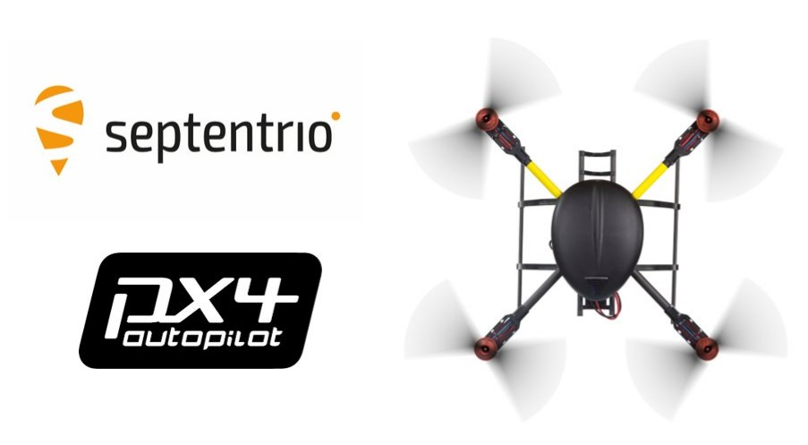
Septentrio’s latest GNSS boards and modules now support PX4 Autopilot for faster integration of high-accuracy positioning into UAVs and robots.
Both the AsteRx-m3 and mosaic receivers support PX4 Autopilot, opening the door to reliable and resilient real-time kinematic positioning.
PX4 Autopilot is one of the largest commercially adopted open-source navigation control stacks, enabling an innovative community to build and maintain drone hardware and software in a scalable way. Drones and robots, which operate autonomously or where a high level of safety is required, now benefit from Septentrio’s accurate positioning receivers, known to be secure against GPS jamming and spoofing with built-in AIM+ Advanced Interference Mitigation technology.
“Our developer community is looking forward to integrating Septentrio’s secure GNSS positioning technology into UAVs and robots, especially in those applications where reliability matters from mapping to surveillance and delivery,” said Ramon Roche, general manager, Dronecode Foundation. “Septentrio’s presence and talk at the PX4 Developer Summit will be an opportunity for developers and integrators to connect with Septentrio and to learn about the latest high-accuracy positioning tech for the PX4 ecosystem.”
“Septentrio has had a fantastic collaboration momentum with Dronecode and the larger PX4 community during the integration of Septentrio receivers into the PX4 Autopilot ecosystem,” said Gustavo Lopez, market access manager at Septentrio. “This collaboration is important because it brings resilient and secure GPS technology to the UAV industry, with tremendous potential in terms of assured positioning and improved safety.”
PX4 is supported by Septentrio’s GNSS boards and modules with both single-antenna and dual-antenna configurations, which offer either heading and pitch or heading and roll angles on top of accurate GNSS positioning.
The Septentrio PX4 driver is freely available on the GitHub.