GPS World Editor-in-Chief, Matteo Luccio, met with Gustavo Lopez, market access manager, Septentrio, to discuss the company’s two new open-source hardware projects and new releases featured at INTERGEO 2023.
Tag: Septentrio
-
Septentrio introduces new open-source projects
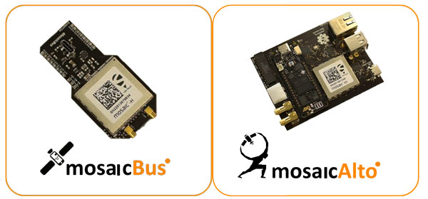
Image: Septentrio Septentrio has introduced two new open-source hardware projects available to integrators of satellite-based positioning.
By expanding their ecosystem of open-source hardware and software, Septentrio aims to make reliable GNSS positioning more accessible to integrators and developers.
The first project, mosaicBus, is a reference design of a board compatible with mikroBUS add-on board standards primarily used in embedded systems. MikroBUS enables easy plug-and-play sensor integration into development boards from major companies such as MikroElektronika, who developed the mikroBUS standard.
The second project, called mosaicAlto, is a carrier board embedding the mosaic-X5 or mosaic-H GNSS receivers, which transforms Arduino Pro Portenta into a single-board computer with a GPS/GNSS receiver.
The mosaicBus board can be used in applications such as automation, robotics or Internet of Things (IoT).
Mosaic is a compact high-precision multi-frequency GPS/GNSS receiver module known for its performance in harsh environments and resilience to jamming and spoofing. The module is designed for systems where accuracy and reliability are required. It has been widely adopted through existing projects such as the mosaicHAT, a shield board for Raspberry Pi and Mowi, a wireless communication board using the mosaic receiver.
In addition to hardware reference designs, Septentrio also supports ROS and several other UAV autopilots.
-
Septentrio, SparkFun partner on positioning-based applications
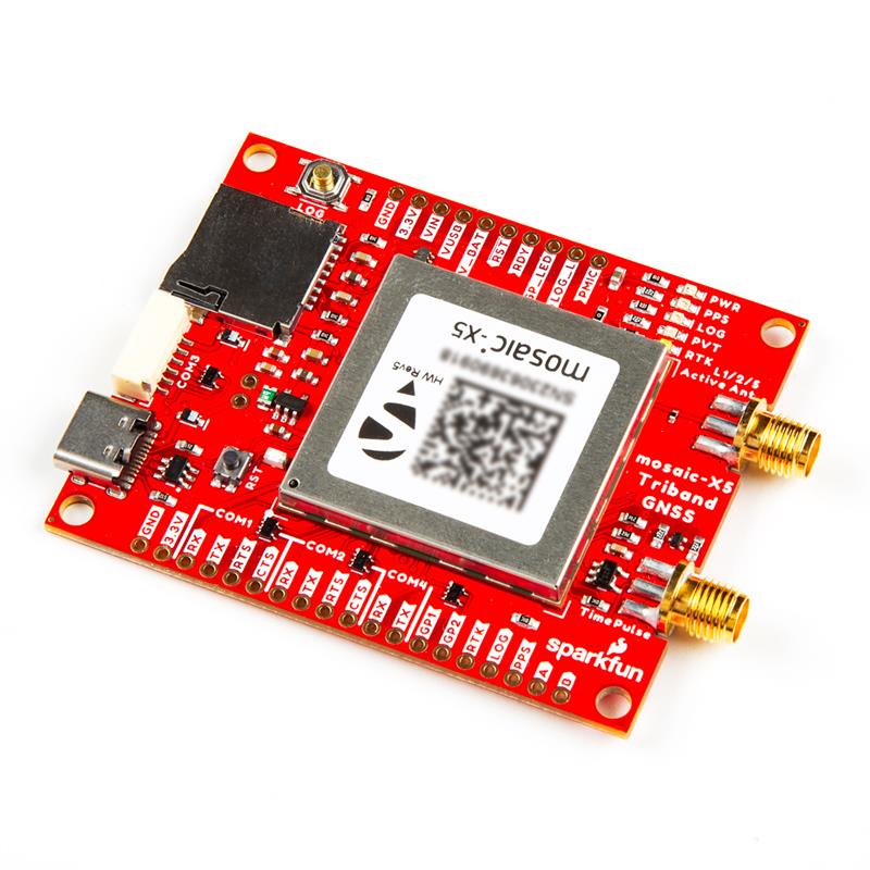
Image: Septentrio Septentrio has partnered with SparkFun Electronics to broaden market reach and the availability of satellite-based positioning products for integrators in a variety of industrial and emerging sectors. As part of the partnership, SparkFun has released its first product, the mosaic-X5 Triband GNSS RTK Breakout board.
The mosaic-X5 Triband GNSS RTK Breakout features the mosaic-X5 receiver module from Septentrio.
The mosaic module is a compact GNSS receiver that delivers high-accuracy tri-band positioning with built-in technology that is resilient to signal interference, including jamming and spoofing. The SparkFun breakout board enables users to log data as well as control and monitor the receiver via the web interface, without the need for additional code.
The mosaic-X5 Triband GNSS RTK Breakout is now available for purchase via the SparkFun website.
-

Topcon joins Septentrio’s Agnostic Corrections Partner Program
Image: Septentrio Topcon Positioning Systems is joining Septentrio’s Agnostic Corrections Partner Program. This program was launched earlier this year to facilitate the use of Septentrio receivers with various high-accuracy services, offering integrators the flexibility to choose the most suitable correction service for their specific application.
Topcon’s Topnet Live is a real-time GNSS corrections service that delivers high-quality centimeter-level real-time kinematic (RTK) corrections data with a broad worldwide network coverage and a variety of subscription options.
“This collaboration with Topcon enables us to bring more high-quality corrections options to our customers,” Gustavo Lopez, senior market access manager at Septentrio said. “Septentrio’s robust GNSS receivers combined with Topcon’s reputable infrastructure creates a powerful synergy that offers high precision and reliability to industrial sectors, including construction and mining, while also catering to emerging applications such as robotics and automation.”
-

EAB Q&A: Is the GNSS community failing to exploit the potential of CSAC?
“Is the GNSS community failing to exploit the potential of chip-scale atomic clocks (CSAC)?”

John Fischer “Yes! And there are several CSAC suppliers, each with varying accuracies, power consumptions, and price points. These atomic clocks are no longer exotic scientific instruments but rather commercialized, proven devices that can be mounted on a circuit card at a reasonable cost. They offer extended holdover time in the absence of GNSS and help with spoofing detection by verifying the incoming signal. They provide exact frequency recovery on power-up (re-trace) for power saving modes. Defense, telecom, financial transactions, and autonomous navigation for cars and drones are all applications that can be made more resilient by these clocks.”
— John Fischer
Safran Navigation & Timing

Jean-Marie Sleewaegen “Atomic clocks, including CSAC, are frequently used in GNSS timing applications, for example to keep accurate time during GNSS outages or to assist in identifying spoofing attacks targeting the time component. On the other hand, the long-term stability of atomic clocks is not particularly relevant in navigation applications where time is not the main output, and the additional cost, power consumption and size of CSAC are not justified.”
— Jean-Marie Sleewaegen
Septentrio

Ismael Colomina “Indeed. After the DARPA-NIST initiative and subsequent commercialization, affordable, accurate and stable chip-scale oscillators can be easily integrated into circuit boards providing additional measurements to PNT systems to improve positional vertical accuracy, as well as reliability and integrity. For example, in high-end mobile mapping systems operating in complex urban scenarios, their use helps detect GNSS outliers at a relatively negligible additional cost.”
— Ismael Colomina
GeoNumerics -

Inside the box: New NavIC clock outperforms previous generation
Image: metamorworks/iStock/Getty Images Plus/Getty Images NVS-01 is the first second-generation satellite of the Indian Navigation Satellite System (IRNSS), also known as Navigation with Indian Constellation (NavIC). It was launched into geostationary orbit on May 20. The satellite is placed at 129.6° eastern longitude and will finally replace IRNSS-1G launched in April 2016.
Whereas the first-generation satellites transmit navigation signals in the L5- and S-band, NVS-01 is the first IRNSS satellite also transmitting in the L1-band. The 1547.42 MHz frequency is also used by other satellite navigation systems, including GPS, Galileo, and BeiDou-3. However, a different modulation is used, namely a Synthesized Binary Offset Carrier (SBOC) signal. The IRNSS L1 SBOC signal has data and pilot components with and without navigation data. Data and pilot signals consist of BOC (1,1) and BOC (6,1) components with sub-frequencies of 1.023 MHz and 6.138 MHz. A quadrature multiplexing is applied for the data and pilot components with a power sharing of 41.82% and 58.18%. The navigation message on the IRNSS L1 signal has a different structure compared to those on the legacy L5- and S-band signals. The new L1 navigation message uses an advanced frame structure and forward error correction inherited from the CNAV-2 message of the GPS/QZSS L1C signal as well as a similar orbit model. Among other things, it provides inter-signal corrections for the L1 data and pilot signals with reference to the S band signal for single-frequency L1 band users.
NVS-01 started signal transmission on June 17, 2023, with the pseudo-random noise (PRN) code I10. The satellite’s L1 and L5 signals were tracked by a Septentrio PolaRx5 receiver located in Tokyo, Japan, with a prototype firmware that is capable of tracking the L1 pilot signal. Figure 1 shows the multipath linear combination of NVS-01’s L1 and L5 pilot signals. Whereas the short-term variations are smaller for L1 compared to L5, the overall RMS is 18 cm for both signals.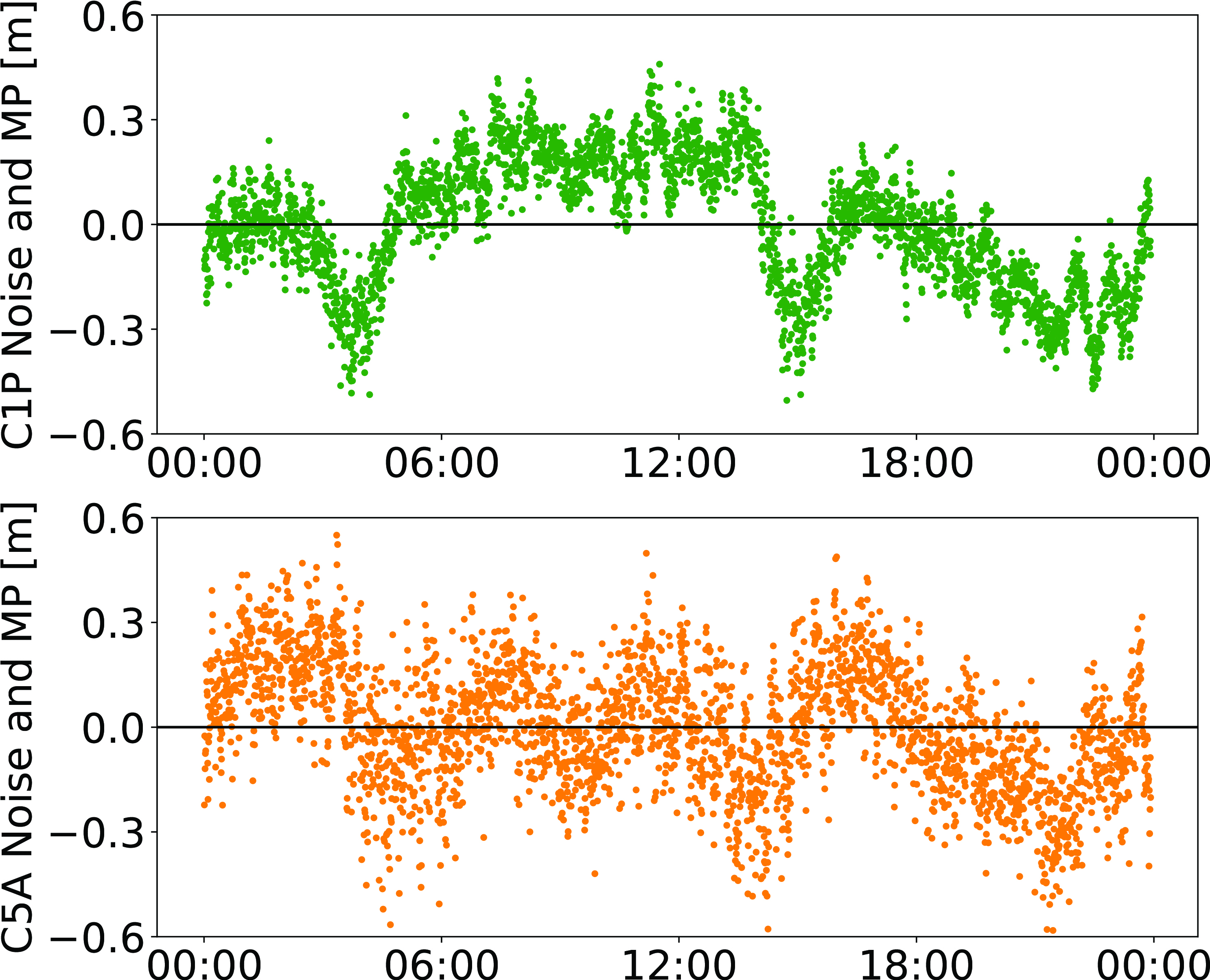
Figure 1: Noise- and multipath linear combination for NVS-01’s L1 and L5 pilot signals received on 26 June 2023. (Image: All figures provided by the authors) Whereas IRNSS-1’s rubidium clocks were provided by Spectratime, NVS-01 is the first satellite operating a new type of rubidium atomic frequency standard (RAFS) developed in India. The short-term performance of GNSS satellite clocks can be evaluated with the one-way carrier phase method. The receiver is connected to a highly stable external clock, e.g., a hydrogen maser. Thus, the receiver clock error is negligible. Measurement biases as well as the delays of ionosphere and troposphere on short time scales are removed by fitting a fourth-order polynomial. If no external clock is available, as is the case for the station in Tokyo, the precise clock information can be transferred from another station by a reference satellite jointly tracked by both receivers.
The Allan deviation based on this three-way carrier phase (TWCP) analysis is shown in Figure 2. The hydrogen maser of the IGS station USUD in Usuda, Japan, is used as the reference clock. At short integration times up to 20 s, the Allan deviation computed from the TWCP analysis is dominated by the GNSS measurement noise hiding the true clock performance. Above 20 s, the TWCP demonstrates that the NVS-01’s RAFS stability meets the performance of the ground tests and even exceeds them for longer integration times. At all integration times, the new RAFS outperforms the first generation IRNSS clocks.
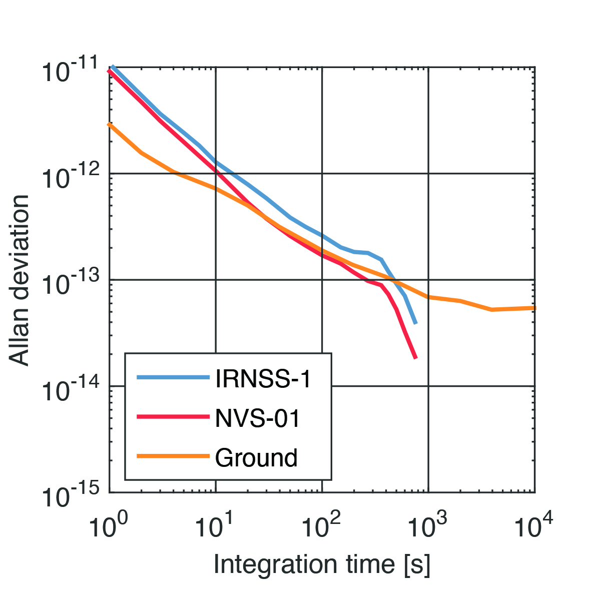
Figure 2: IRNSS clock performance obtained from three-way carrier phase analysis as well as ground tests. Manufacturers
GNSS data used in this article were collected with a Septentrio PolaRx5 receiver.
Further Reading
Bandi TN, Arora R (2019) Indigenous Atomic Clock and Monitoring Unit for NavIC. ICG-14, https://www.unoosa.org/documents/pdf/icg/2019/icg14/WGD/icg14_wgd_09.pdf
ISRO (2022) NavIC Signal in Space ICD for Standard Positioning Service in L1 Frequency, Version 1.0. U.R. RAO Satellite Centre, Indian Space Research Organization, Bangalore, https://www.isro.gov.in/media_isro/pdf/SateliteNavigation/Draft_NavIC_SPS_ICD_L1_Oct_2022.pdf
Peter Steigenberger and Oliver Montenbruck are scientists at the German Space Operations Center of the German Aerospace Center (DLR), where they conduct research in the field of new satellite navigation systems.
Jean‑Marie Sleewaegen is Lead Architect at Septentrio, Belgium, where he has been responsible for GNSS signal processing, system design and technology development since the company’s inception in 1999.
-
New Receivers for More Signals

JAVAD GNSS’ Triump-1M Plus receiver has 874 channels for acquiring all available GNSS satellites and patented mobile antenna technology for robust UHF and cellular communications. (Image: JAVAD) As most readers of this magazine know, GPS, like the other three GNSS, consists of three segments: the space segment — i.e., the satellites; the control segment — i.e., the monitoring and control stations on the ground around the world; and the user segment — i.e., the receivers. The first two are developed, operated and maintained by the U.S. Space Force, while the third one, for civilians, is totally in the hands of the private sector.
Most of the progress in receivers is evolutionary, with rare dramatic changes. To provide a snapshot of the current state of GNSS receivers, I asked several manufacturers three questions. What follows are short, etre dited excerpts of their answers that showcase the applications of GNSS receivers in a wide range of industries.
The participants in this cover story are:
- Eos Positioning Systems Inc. — Sarah Alban, Director of Marketing
- JAVAD GNSS — Simon Baksh, VP Product Development
- Hexagon’s autonomy & positioning division — Stephen Ching, Core Segment Manager
- Trimble — Karl Bradshaw, Market Manager, Mobile Mapping
- u-blox — Oreste Concepito, Head of Product Strategy Positioning
- Septentrio — François Freulon, Head of Product Management
- Hemisphere — Miles Ware, VP of Marketing
- Geneq — René Parisé, President
What is one of the most recent end-user applications for your receivers? What challenges does it pose and how do your receivers address them?
Sarah Alban (SA): Eos Positioning Systems is lucky to have innovative customers who span a variety of industries. In just these past few weeks, we’ve connected to customers who are using Arrow Series GNSS receivers to meet myriad business needs. Here are just a few examples: On the Caribbean island of Martinique, Odyssi uses an Arrow 100+ with RTK to get accurate water utility locations in a challenging environment. In Texas, midstream pipeline operator Kinetik and its GIS Manager Papillon Romero equip their field workers with an Arrow Gold to update the locations of previously unreliable legacy as-builts. In the Galápagos Islands, a researcher has been using the Arrow Gold+ and Galileo High Accuracy Service (HAS) to georeference drone imagery. In Colorado, GIS specialist Jim Casey uses an Arrow Gold to bring to life a Japanese internment camp in augmented reality.
Simon Baksh (SB): One of our customers is a leading construction contractor who uses our DELTA GNSS receiver for monitoring during deep crack grouting deformation to ensure that the natural state of the ground remains undisturbed during remedial work.
Stephen Ching (SC): One of the most exciting projects happening within Hexagon’s Autonomy & Positioning division is the automated road train platooning application within the mining industry. Transporting raw materials, iron ore in this case, has posed a huge challenge in terms of drivers’ safety, labor shortages and rising fuel costs. Our division is currently developing an autonomous hauling system that solves this challenge by integrating drive-by-wire, perception, positioning and path planning technologies. Our positioning system utilizes a PwrPak7D-E2 plus TerraStar-C PRO solution from Hexagon | NovAtel, which incorporates GNSS+INS technology and real-time kinematic (RTK) From the Sky technology.

Mobile mapping systems such as the Trimble MX50 allow survey companies to safely and accurately gather point cloud and immersive imagery of roads without the need to put a surveyor in the field. (Image: Trimble) Karl Bradshaw (KB): Traditional survey methods or tripod-based scanning on highways can be time-consuming and dangerous. Survey companies do not want to put surveyors in danger of traffic while traversing along a road. Mobile mapping allows them to safely, accurately and productively gather detailed point cloud and immersive imagery of highways without needing to put a surveyor in the field.
Oreste Concepito (OC): At u-blox, we have seen an increasing demand for GNSS receivers to be used for advanced driver-assistance systems (ADAS) applications and for mobile robotics (such as robotic lawnmowers). GNSS technology is adopted when an accurate, trustworthy position with high availability is required. In the autonomous operations domain, customers are constantly pushing u-blox to improve dependability while maintaining or ideally improving position accuracy, even in challenging environments.
François Freulon (FF): One of our most recent end-user applications is related to resilient timing for mission-critical infrastructure, including finance, data centers, energy and telecommunications. The relevant Septentrio product is the mosaic-T. The recent addition of the AtomiChron timing service further enhances its timing precision, GNSS resilience and anti-spoofing by offering navigation message authentication (NMA) on all for GNSS constellations. The first customer integrating this technology is Meinberg.
Miles Ware (MW): The Galileo High Accuracy Service (HAS) has created new interest in a traditional GNSS market, GIS and mapping, in which the availability of global 20 cm accuracy is turning many heads. While there are many technologies to improve accuracy for this market, few are appropriate. Often the work takes place in remote areas where cellular connectivity is not available for delivering corrections. They may also be in regions of the world where satellite-based augmentation systems (SBAS) are not available or able to meet performance expectations. Galileo HAS resolves both of these concerns. We now support it in our Phantom and Vega receivers.
In the past few years, we have seen the completion of two new GNSS constellations and a large increase in the options for corrections services. How has this impacted the design and/or features of your receivers?
SB: Our 874 channel TRIUMPH ASIC design has capacity for all constellations and signals to utilize current and future GNSS technologies. Additionally, our J-Star PPP Service using geostationary satellite broadcast for global delivery and cm level positioning extends operations to remote areas where networks are absent or where a base station setup and operation is not feasible.
SC: With BeiDou and Galileo in addition to GPS and GLONASS, there can be upward of 40 satellites in view — compared to 20 years ago when having 10 or 12 satellites in view was considered good availability. This gives much more choice as to which measurements contribute to a position solution, provided that the receiver can make measurements to all the satellites in view. Hexagon | NovAtel’s OEM7 was designed to support all GNSS constellations and frequencies, which required supporting many channels as well. The benefits of more satellites in the sky come under challenging conditions with many obstructions and strengthened positioning geometry in unobstructed conditions. In addition to more satellites, BeiDou and Galileo also introduced a new frequency at E6/B3, in addition to L1/L2/L5, which is particularly useful in global PPP solutions, such as RTK From the Sky and TerraStar C-PRO Correction Services.
KB: We have onboarded these constellations into our mobile mapping portfolio in the same way as all other Trimble GNSS portfolios, through rigorous, tried and tested methodologies.
FF: Septentrio receivers already support all GNSS constellations for high precision and resilient positioning. We have added Galileo E6 support and OSNMA, BeiDou phase III satellites (PRN>37) and other new signals (B3I, B2b) to our products through our latest firmware releases. We are also contributing to the large increase of corrections services by providing the backend core technology through our base station receivers or reference receivers. For example, the PolaRx5 reference receivers are used worldwide in many correction network infrastructures. With the support of all in view constellations and signals, Septentrio products are becoming part of critical infrastructure. Therefore, it is essential they have reliable continuous operation as well as security to protect them from potential jamming or spoofing attacks. Additionally, Septentrio has recently launched the Agnostic Corrections Partner Program to help customers find their way in the growing maze of correction offerings and to facilitate the integration of the right service into their system.
Geneq Inc. employee Alex Arsenault operating an SXblue Platinum receiver in Anjou, Montreal. (Image: Nikita Sapeguine / Geneq) OC: Our customers are increasingly operating in a global market. To respond to that need, u-blox receivers support both the global and the regional constellations, such as Japan’s Quasi-Zenith Satellite System (QZSS) and India’s Indian Regional Navigation Satellite System (IRNSS, aka NavIC). The offer for correction services has also evolved to be able to serve the global market, moving toward uni-directional streams, possibly distributed via L-band. We support a complete portfolio of correction services, responding to all commercial and performance requirements, from the soon available, free-of-charge, lower accuracy correction services, up to the dm-level functional safety-certified correction services for autonomous driving.
MW: Since 2019, our core receiver technology has been intrinsically both multi-GNSS and multi-frequency by design. This allows our engineering team members to rapidly adapt to new and emerging solutions, and for Hemisphere to meet user and market demands. Hemisphere has also worked with our integrators to recognize the need to simplify the decision process around selecting receivers. While it is possible to configure our receivers to track specific constellations only, Phantom and Vega are being offered with multi-GNSS as standard. Similarly, clients can choose L1-only, or all-frequencies. This is why many integrators will quickly be able to take advantage of Galileo HAS.
RP: We have upgraded our SXblueGPS receivers with new GPS chips and with firmware updates to keep up with the new constellations available. Regarding the new correction services, the SXblueGPS have used and use by default the SBAS correction service and its associated networks throughout the planet to improve their precision. Where correction services via internet or SBAS do not exist, they use L-band correction services to have global coverage. In some cases, for topography base and mobile solutions, UHF links provide a customized correction service.
Are jamming and spoofing significant challenges in your key markets? If so, how do you address them?
SB: Yes, and AJ/AS expands on existing RAIM for assured position quality. Patented anti-jamming and anti-spoofing techniques identify and suppress GNSS interference, while maintaining navigation from good signals. Updated firmware for Navigation Message Authentication extends AJ/AS protection further.
SC: GNSS interference such as jamming and spoofing do present significant positioning challenges in many of our markets, especially defense, marine and autonomy applications in which safety and 24-7 operation are paramount. How often GNSS interference happens (and is detected) and how seriously it affects the application depends on the market. It is a threat that can be mitigated by well-designed user equipment. Hexagon | NovAtel has developed a comprehensive GNSS resiliency portfolio to assure that our users’ position is protected with our interference mitigation technology, starting from the GAJT antennas all the way down to the receiver level. NovAtel’s OEM7 receivers include our GNSS Resilience and Integrity Technology (GRIT) firmware options, which provides spoofing detection, interference detection, and mitigation with digital filters, as well as time-tagged digitized samples for advanced situational awareness.
KB: As it applies to mobile mapping with the Trimble MX50, jamming and spoofing are not significant challenges.
OC: A team of engineers is constantly improving our anti-jamming and anti-spoofing technology. U-blox customers are today more mindful of the risks associated with GNSS interference, both intentional and unintentional. GNSS is adopted in critical infrastructures and autonomous vehicles, where jamming and spoofing could lead to severe consequences. While no system can be safe in absolute terms, increasing the sources of information can greatly improve the resilience against jamming and spoofing attacks. Multi-constellation GNSS receivers, multi-band constellations, inertial sensors and accelerometers, can all be individually used as additional safety layers contributing to a more robust solution. Additional measurements are implemented at the positioning engine level, as part of our functional safety program. The availability of authenticated signals, being introduced by Galileo’s Open Service – Navigation Message Authentication (OS-NMA), will also contribute to increasing the GNSS robustness against interference.

Hemisphere GNSS’ GradeMetrix is a machine guidance solution for GNSS-based machine control and guidance applications. (Image: Hemisphere) FF: Definitely, and we are seeing a large increase in demand for resilience in many applications and for assured positioning, navigation and timing (PNT). Providing trustworthy information is critical now for many markets, such as machine control, robotics, timing, infrastructure and assured PNT. Our multi-frequency multi-constellation GNSS technology not only maximizes accuracy and availability in areas where the sky is partially obstructed, but also provides extra resilience against jamming and spoofing. All our GNSS receivers are resilient to jamming and spoofing thanks to the built-in Advanced Interference Mitigation (AIM+) technology, which suppresses the widest variety of interferers, from simple continuous narrow-band signals to the most complex wideband and pulsed transmissions.
MW: Fortunately, jamming and spoofing are not common occurrences in most of our markets. However, their nature is such that they can appear at any time, in any place, without warning. This can cause otherwise routine plans for users to suddenly grind to a halt. Hemisphere’s Cygnus interference solution provides protection against up to 60 dB of jamming and is built into our current generation products by default. Having Cygnus available can make the difference between working normally and searching for alternate solutions. A welcome tool offered through Galileo satellites is OS-NMA signal verification, which provides excellent protection against spoofing attacks. Firmware updates provide our current product platforms access to OS-NMA spoofing protection. As our standard products are already activated for multi-constellation operation, it simplifies integration for our users.
RP: Interference is inevitable given the enormous number of signals from telephone and electrical networks, among others, as well as buildings, trees and, of course, the weather. To mitigate this, we use multi-frequency and multi-GNSS antennas that allow us to obtain the best reception in areas of interference. Additionally, we have state-of-the-art GPS chips that block and purify signals that generate distortion. On the other hand, there is interference by intentional GNSS falsifications or by radio amateurs who transmit radio signals for drones and other devices that cause GPS signal loss, which are mitigated by the latest technology algorithms of our SXblueGPS.
-
Launchpad: Laser scanners, rovers and PNT devices
A roundup of recent products in the GNSS and inertial positioning industry from the August 2023 issue of GPS World magazine.
SURVEYING & MAPPING
 Laser Scanner
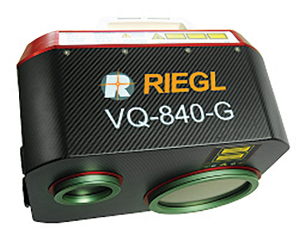
With several integration optionsThe VQ-840-G is a fully integrated compact airborne laser scanner designed for combined topographic and bathymetric airborne and UAV-based surveying. The system is offered with an optionally integrated and factory-calibrated inertial measurement unit/GNSS system and can be complemented with an optional camera or IR rangefinder. It also has an optional integrated inertial navigation system. The scanner carries out laser range measurements for high resolution surveying of underwater topography with a narrow, visible green laser beam, emitted from a pulsed laser source. The VQ-840-G has high spatial resolution due to a measurement rate of 200 kHz and high scanning speed of up to 100 scans/second.
Riegl, riegl.com
Laser Scanning System
A versatile reality capture solution suitable for surveying, construction and engineering usersThe X9 is designed to enhance performance in more environments while leveraging Trimble’s X-Drive technology for automatic instrument calibration, survey-grade self-leveling and laser pointer for georeferencing. The X9 expands on Trimble’s X7, delivering longer range, higher accuracy, shorter scan times and sensitivity, improving scan results. Advanced processing and a high-performance laser increase the sensitivity of all scans, enabling the X9 to capture difficult dark or reflective surfaces. A new center unit design also improves signal transmission for better scan quality. The X9 provides accurate and dependable data, enabling confident decision making both in the field and in the office through in-field registration with Trimble Perspective and FieldLink software by minimizing the need for target deployment. The auto-calibration eliminates the need for annual calibration. In addition, the X9 includes survey-grade self-leveling with the industry’s widest compensation range for fast, easy setup. The X9 data can be delivered directly from the Perspective or FieldLink software to Trimble’s office software — including the Realworks 3D scanning software — business center office software, SketchUp and Tekla, or exported to industry-standard formats to produce application-specific deliverables.
Trimble, trimble.com
Survey Cameras
For photogrammetric applications and to complement lidar survey dataThe C5 and C30 orthographic and oblique cameras are designed for aerial surveys. The systems provide high-quality imaging solutions for photogrammetric applications and to complement lidar survey data. The C5 camera is an efficient and lightweight system for aerial surveys, weighing 290 g for increased flight endurance. Its compact size of 75 mm x 63.5 mm x 102.5 mm allows easy integration into UAVs. The C30 camera’s weight is 600 g with a size of 110mm x 108 mm x 85 mm. The C30 is also designed for aerial surveying. The C5 and C30 cameras’ universal installation design makes them compatible with a wide range of fixed-wing and rotor UAV platforms. Both cameras are supported by the CHCNAV’s BB4 Mini and P330 Pro UAVs as well as the DJI’s M300 RTK. The C5 and C30 cameras give maximum flexibility for photogrammetric applications. They can be used independently on real-time kinematic-enabled UAVs to capture high-resolution imagery or installed directly on the CHCNAV’s lidar series to colorize point cloud data. This feature allows seamless imagery and lidar data integration for a more complete view of the surveyed area.
CHC Navigation, chcnav.com
GNSS Palm RTK
For surveying and mapping, GIS and moreThe T20 is light, weighing 0.68 kg, and has low power consumption with 12 hours of battery life. It integrates functions such as a GNSS module, datalink module, 4G, 5.0 dual-mode Bluetooth, data memory system and more. Powered by the SinoGNSS K8 high precision module, the T20 has 1,590 channels and can track all running and planned constellations including GPS, BDS, GLONASS, Galileo, QZSS and satellite-based augmentation systems. Additionally, the anti-interference algorithm enables the T20 to maintain accurate positioning and perform well in complex environments, providing surveyors with high-quality measurements. The T20 is equipped with a third-generation inertial measurement unit from ComNav, which can be tilted and measured at an angle up to 60°. The T20 is also equipped with a U50 datalink module, which enables it to switch between base and rover. The T20 is compatible with mainstream real-time kinematic receivers on the market.
ComNav Technology, comnavtech.com
Hybrid Imaging and Lidar Sensor
Designed for airborne mappingThe CountryMapper is designed for large-area imaging and lidar mapping. Combining a large-format photogrammetric camera with a high-performance lidar unit into a single system, the CountryMapper collects foundational geospatial data simultaneously to support a wide variety of user applications. The CountryMapper combines imaging and lidar sensor modules into a highly efficient hybrid airborne system. The sensor features CMOS-based Leica MFC150 camera modules that leverage true mechanical forward-motion-compensation to deliver high image quality. The sensor’s new Hyperion3 lidar unit features 60° field of view, improving the performance and flexibility of the system compared to previous lidar modules, while reduced laser divergence provides greater planimetric accuracy and better foliage penetration. The CountryMapper fully integrates with Leica HxMap multi-sensor end-to-end processing workflow, enabling distributed processing of images and point clouds to optimize productivity for very large data sets. The CountryMapper supports applications such as orthophoto generation, terrain mapping, hydrography, forestry monitoring and infrastructure management. Users of previous-generation sensors can leverage their initial investment and upgrade their systems to the CountryMapper configuration.
Leica Geosystems, leica-geosystems.com
MOBILE
GNSS Network Rover
Complete with an integrated MEMS IMUThe Triumph-3NR (T3-NR) is a small, lightweight GNSS network rover with more than 25 hours of run time on a single charge. The T3-NR easily connects to real-time networks for corrections to get GNSS real-time kinematic with inertial measurement unit tilt compensation. The network rover has 874 channels and can track all constellations. It features an internal GNSS antenna, Wi-Fi, Bluetooth, and is USB compatible. The T3-NR is suitable for demanding industrial applications.
JAVAD, javad.com

Antennas
Suitable for lawn mowers and other mobile applicationsThe HX-CSX014A is a high gain, low profile and compact antenna with a new structure that simplifies integration into lawn mowers and minimizes the overall machine dimension. It features small size, high sensitivity and low power consumption. The HX-CSX231A, is a ready-to-use GNSS antenna with a highly reliable structure that makes it small and lightweight. It exhibits 4.5 dBi high gain performance with ultra-low signal loss. It also delivers wide beam width that covers wide frequencies with high marginal gain, a perfect option in complex environments. Additionally, the HX-CSX231A’s advanced LNA features improved signal filtering, out-of-band rejection, restrained unwanted electromagnetic interferences and a strong multi-path reduction capacity.
Harxon, en.harxon.com
DEFENSE

PNT Device
Enables dismounted maneuver operations even where GPS is compromised or deniedThe TRX DAPS II provides assured positioning, navigation, and timing (PNT) to dismounted users by disseminating assured position and time to dependent devices in GPS-challenged environments. TRX DAPS II fuses inputs from M-code GPS, inertial sensors, and complementary PNT sources. It is a small, lightweight PNT device that supports both standalone operation and integration with the Nett Warrior ensemble. It also can distribute PNT information to a customized tactical watch. The TRX DAPS II solution employs a modular architecture and adheres to Army PNT interface standards, facilitating the addition of new PNT sensors as threats evolve. This device will be in production for the Army later this year.
TRX Systems, trxsystems.com
TIMING
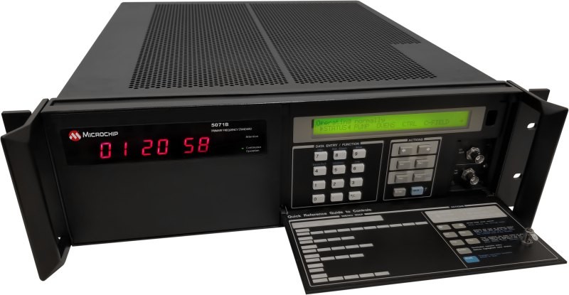
Image: Microchip Technology Atomic Clock
Maintains system synchronization when GNSS signals are deniedThe 5071B cesium atomic clock can perform autonomous time keeping for months in the event of GNSS denials. This device is the next-generation commercial cesium clock to the 5071A. The 5071B is available in a three-unit height, 19-in rackmount enclosure, providing a compact product to work in environments where it can be easily transported and secured versus a larger alternative designed specifically for laboratory environments. The 5071B has upgraded electronic components to address possible obsolescence or non-RoHS circuitry. The clock provides 100 ns holdover for more than two months, maintaining system synchronization when GNSS signals, such as GPS, are denied. As a cesium beam tube product with no deterministic long-term frequency drift, the 5071B provides absolute frequency accuracy of 5E-13 or 500 quadrillionths over all specified environmental conditions for the life of the product. For military applications requiring rapid deployments for system radars, 5E-13 stability eliminates the need for the acquisition of external synchronization sources prior to radiating.
Microchip Technology, microchip.com
OEM

GNSS Positioning Modules
For multiple applicationsautomation of moving industrial machinery, and the ZED-F9P-15B provides customers in the mobile robotics market with an L1/L5 option in addition to the L1/L2 bands. These two modules are based on the u-blox F9 high-precision GNSS platform. The NEO-F9P and the ZED-F9P-15B GNSS modules feature concurrent reception of GPS, Galileo, and BeiDou; multi-band L1/L5 real-time kinematic; short convergence times; and reliable performance. The modules deliver centimeter-level accuracy in seconds and come in small, high-precision form factors.
Its small size, coupled with very low power consumption and ANN-MB1 antenna compatibility, makes the NEO-F9P suitable for a wide range of uses. Offering reliable and efficient positioning, the module supports open as well as standards-based correction services for enhanced performance, such as the u-blox PointPerfect GNSS augmentation service.
u-blox, u-blox.com
Image: Septentrio GNSS Receiver Module
Features built-in AIM+ technology for interference mitigationThe mosaic-X5 is a multi-band, multi-constellation GNSS receiver in a low power surface mount module with a wide array of interfaces. It is designed for mass market applications such as robotics and autonomous systems — capable of tracking all GNSS constellations, supporting current and future signals. The mosaic-X5 has an update rate of 100 Hz, is easy to integrate, and is optimized for automated assembly. The mosaic-x5 is suitable for autonomous vehicles, logistics and port operations, mining and construction, precision agriculture, rail, robotics, surveying and mapping, UAVs and more.
Septentrio, spetentrio.com -

OEMs take tech to the next level
OEM products are vital to many industries. Companies such as Septentrio and SBG Systems design and produce a variety of OEM devices for many different applications. (Image: sankai/E+/Getty Images) OEM devices are an integral part of many applications requiring precise positioning technology. As the OEM market grows and performance requirements become more demanding, it is critical for OEM devices to be reliable, accurate, and easy to integrate. From precision agriculture, to surveying and mapping, to UAV missions, there are OEM devices on the market suitable for demanding applications.
Survey and Map Like a Pro
Surveying and mapping is one area in which OEM boards are embedded deep in many products. Septentrio designs and manufactures multi-frequency, multi-constellation, GPS/GNSS positioning technology and offers a variety of OEM products for demanding applications.
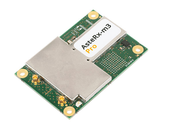
Image: Septentrio The AsteRx-m3 Pro is an ultra-low power GNSS rover receiver. It is compact and high-performance, making it suitable for integration into high-precision industrial applications. It incorporates multi-frequency, multi-constellation GNSS technology as well as anti-jamming algorithms for availability and reliability. The AsteRx-m3 Pro features AIM+ advanced anti-jamming and anti-spoofing technology as a part of Septentrio’s GNSS+ Technology Suite.
This receiver is designed for rover (mobile) applications, making it an easy-to-integrate solution for any kinematic application where reliable high-accuracy positioning is needed. It is available in single or dual antenna mode, for high quality heading and pitch, or heading and roll information.
GNSS heading is available directly from initialization and removes reliance on vehicle dynamics or magnetic sensors. This is an optional feature.
“Septentrio OEM receivers come in a variety of form factors, from compact modules to credit-card boards,” Danilo Sabbatini, OEM product manager at Septentrio, stated. “Our multi-frequency OEM receiver portfolio includes products that fit various user needs from purely rover GNSS high accuracy positioning to heading receivers, as well as GNSS/INS boards for inertial navigation or mapping.”
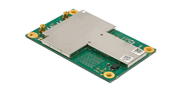
Image: Septentrio Aside from surveying and mapping, the AsteRx-m3 Pro is suitable for assured position, navigation and timing (PNT), autonomous vehicles, precision agriculture, logistics and port operations, mining and construction, rail, robotics, space and UAV applications.
Plowing the Way
The increase in demand for food due to population growth challenges farmers to increase production. To help them do this, Septentrio is working with manufacturers of agricultural machinery to enable them to achieve centimeter-level positioning accuracy.
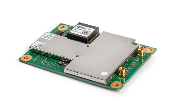
Image: Septentrio The AsteRx-i3 D Pro is a ready-to-use GNSS/INS single-board receiver that delivers reliable centimeter-level positioning combined with 3D orientation (heading, pitch and roll) in demanding environments. Its inertial sensor provides orientation and positional dead-reckoning, making it suitable for systems that require continuous positioning even during short GNSS outages. It provides reliable and accurate positioning by enhancing GNSS with an inertial measurement unit (IMU).
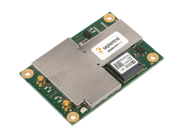
Image: Septentrio The AsteRx-i3 D Pro is quad-constellation and multi-frequency. It provides all-in-view real-time kinematic positioning and features AIM+ unique interference monitoring and mitigation system and other advanced GNSS+ algorithms.
Like the AsteRx-m3 Pro, the AsteRx-i3 D Pro is also suitable for assured PNT, autonomous vehicles, logistics and port operations, mining and construction, rail, robotics, space, survey and mapping, and UAV applications.
For more information about Septentrio’s OEM boards, click here.
Flying High
SBG Systems has released Ekinox Micro, a compact and rugged high-performance inertial navigation solution designed to deliver accuracy in challenging environments. Ekinox Micro combines a high-performance MEMS tactical inertial sensor with a quad-constellation, dual-antenna GNSS receiver, making it suitable for mission-critical applications.
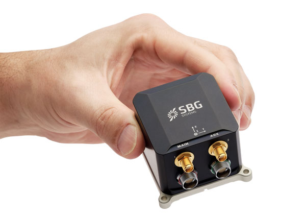
Image: SBG Systems GPS World caught up with Yoann Plénet, head of products at SBG Systems, at AUSVI XPONENTIAL in May. He elaborated on Ekinox Micro’s key markets and features.
“This is Quanta Micro in a box with the same performance and the same benefits that you get [with the Quanta Micro]: inertia, enhanced GNSS, and complement[ing] the GNSS,” Yoann said. “At the same time, we are targeting very rough environments, especially larger drones which are most likely military ones. So, [Ekinox Micro] is a very rugged product.”Ekinox Micro includes pre-configured motion profiles for land, air and marine applications, enabling the sensor and algorithms to be tuned for maximum performance in any condition. The device is designed for ease of use and integration, with simple connectors, a web configuration interface, a datalogger, Ethernet connectivity, a PTP server, a REST API for configuration, and multiple input and output formats.
Image: SBG Systems Ekinox Micro is compatible with real-time kinematic (RTK) and based on a tactical 0.8°/h class inertial measurement unit calibrated across the entire operating temperature range. It features accuracy roll/pitch of 0.015°, accuracy heading of 0.035°, and accuracy position of 1.2 m without any corrections or 1 cm in RTK.
Yoann also said that with the rise of jamming and spoofing, Ekinox Micro is designed with enhanced technology to mitigate those threats.
“Jamming and spoofing is ongoing and is an issue for more and more of our clients. So, we have worked a lot — and that is something that is beneficial to all of our product ranges — on enhancing our algorithms and our technology so we can better detect jamming and spoofing than we could before,” Yoann said.
Ekinox Micro will be commercially available in September. Click here for more information on Ekinox Micro.
Bonus Device
Image: Septentrio The Septentrio mosaic-X5 is a multi-band, multi-constellation GNSS receiver in a low power surface mount module with a wide array of interfaces. It is designed for mass market applications such as robotics and autonomous systems — capable of tracking all GNSS constellations, supporting current and future signals.
The mosaic-X5 has an update rate of 100 Hz, is easy to integrate, and is optimized for automated assembly.
Antoon De Proft, Septentrio’s CEO, mentioned in the April 2023 issue of GPS World the company’s innovation in Leuven, Belgium.“Septentrio’s 20 years of experience in GNSS technology as well as our strategic partnership with the European Space Agency and close collaboration with the IMEC semiconductor technology hub has enabled us to produce the mosaic-X5 receiver,” he said. “This compact module is one of the highest performing and resilient GNSS receivers on the market. It is used in a wide array of applications, especially where the position is mission critical. Examples include a wide variety of autonomous devices, including drones that benefit from mosaic’s lightweight and low-power design.”
Francois Freulon, head of product management, added, “Reliability and resilience to GNSS vulnerabilities is a key pillar on which we base our receiver design. RF interference in the form of jamming and spoofing* is increasingly common, which is why we are investing heavily in securing our receivers at the core with the latest hardware and software techniques. In addition to the AIM+ patented technology, the mosaic module already includes OSNMA functionality, which will offer end-to-end authentication on Galileo’s civilian signals, protecting receivers from GNSS spoofing attacks.”
For more information about Septentrio’s mosaic GPS/GNSS modules, click here. -
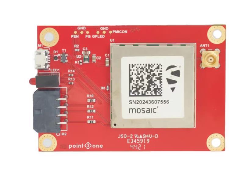
Septentrio and Point One Navigation partner to expand portfolio across Europe
GNSS interface board – mosaic. (Image: Point One Navigation) Point One Navigation and Septentrio have partnered to expand upon the companies’ precision location solutions throughout Western Europe. The new developer compatibility is suitable for demanding applications, including industrial autonomy, precision agriculture, logistics and delivery, robots and autonomous vehicles.
Point One’s Polaris is a correction network that enables high-precision GPS and computer vision-based localization. Polaris has recently extended coverage to now include Western Europe, further expanding the reach of the network. This solution is powered by Septentrio’s GNSS receivers, including the mosaic compact multi-constellation GNSS receiver.
The mosaic module — a multi-band, multi-constellation receiver in a low-power surface-mount module with a wide array of interfaces — is designed for mass market applications such as robotic and autonomous vehicle guidance systems. The module integrates GNSS and RF ASIC technology, as well as the robust positioning engine from Septentrio.
Septentrio real-time kinematic (RTK) receivers can be used directly with Polaris to provide centimeter-level accuracy in seconds.
This technology is complemented by Point One’s FusionEngine software, which further integrates cameras and additional sensors to achieve the desired level of precision — even in the complete absence of satellite signals.
FusionEngine has the accuracy and the resilience to inclement weather required by Level 2 applications, such as highway lane keeping and V2X, while offering the robustness necessary for mission-critical Level 4 and Level 5 robotaxi and full autonomy applications.
-
Septentrio timing GNSS module now supports Fugro AtomiChron
Image: Septentrio Septentrio’s compact GNSS timing module, mosaic-T, now supports the AtomiChron timing service from Fugro. The mosaic-T module already includes several layers of security against GNSS jamming and spoofing with AIM+ integrated technology and OSNMA Galileo authentication; however, AtomiChron further strengthens the anti-spoofing security of the mosaic-T receiver by offering navigation message authentication on all four major GNSS constellations.
Fugro AtomiChron includes navigation message authentication, which ensures timing resilience through reception of only genuine GNSS signals. The AtomiChron eliminates time drift caused by clocks counting time at slightly different rates. This achieves sub-nanosecond accuracy and provides extreme stability that surpasses current precision frequency standards. This is a lightweight and scalable solution, which removes the need for atomic clocks in critical infrastructure.
The mosaic-T delivers accurate timing with multi-frequency, multi-constellation GNSS technology and offers dedicated timing features and inputs for time and clock synchronization. AtomiChron capability can be obtained via a software upgrade for new receivers or for receivers which are already operational in the field.
The AtomiChron service is optional and can be activated through Fugro. To find out more about mosaic-T or the secure positioning receivers from Septentrio use the Product Finder tool or contact the Septentrio team.
-
Editorial Advisory Board: GNSS constellations and receivers
Which GNSS constellations do most receivers currently use? How is that mix changing?

“Most modern commercial receivers today are moving to receive all GNSS signals: GPS, GLONASS, Galileo, BeiDou, QZSS, IRNSS and so forth. Also important, in which bands does the receiver operate, and how many channels does it have for optimum accuracy and quicker cold start? Application and location for local stability are also factors. If the operation is in India, IRNSS would be important, in Japan QZSS, and so forth.”
— Ellen Hall
Imminent Federal
“The current standard in commercial receivers is to exploit the interoperability between the various GNSS signals and to make use of all satellites in view, regardless of their constellation. While the L1/E1/B1 frequency band continues to be the primary frequency in almost all GNSS systems, the legacy L2 band is gradually losing its importance as most satellites are already broadcasting more advanced signals in the L5/E5 band.”
— Jean-Marie Sleewaegen
Septentrio

“The newest phones offered by Google and the largest manufacturers in the world — Apple, Samsung, OPPO and Vivo — support the following positioning systems: Google — Pixel 7 and Pixel 7 Pro: GPS, GLONASS, Galileo, BeiDou, QZSS, and other // Apple — iPhone 14: GPS, GLONASS, Galileo, QZSS, and BeiDou // Samsung — S23 and most other recent versions: GPS, Galileo, GLONASS, and BeiDou // Xiaomi — Xiaomi 13 Pro: GPS (L1+L5), Galileo (E1+E5a), GLONASS (G1), BeiDou, NavIC (L5A-GPS supplementary positioning) // OPPO — F21: GPS, A-GPS, BeiDou, GLONASS, Galileo, and QZSS // Vivo — Vivo X90: GPS, A-GPS, GLONASS, Galileo, BeiDou, QZSS, NavIC, Cell ID, Wi-Fi. // For farming, John Deere’s SF-RTK uses GPS, GLONASS, BeiDou and Galileo.”
— Bernard Gruber
Northrop Grumman
 “All modern generation cell phones use virtually all GNSS signals. This includes GPS, Galileo, GLONASS and BeiDou. In addition, they receive the correction signals, such as WAAS and EGNOS. This capability is embedded in the chips that are currently used. We are told that they have the capability to track on the order of 50 satellites at once. We expect that dual frequency is close to realization and the use of the new civil L5 signal will make cell phones even more capable.”
— Bradford W. Parkinson
Stanford Center for Position, Navigation and Time