The Space Systems Command (SSC) Space Sensing program executive office, headquartered at Los Angeles Air Force Base in El Segundo, California, has delivered the first of two future operationally resilient ground evolution (FORGE) software deliveries to operations in the Overhead Persistent Infrared (OPIR) Battlespace Awareness Center (OBAC) at the Buckley Space Force Base in Colorado.
The integration of the FORGE framework into OBAC operations offers increased cyber resilience and enhanced mission applications to operators. OBAC operations on FORGE aim to boost OPIR battlespace awareness and technical intelligence missions with significant cyber-security improvements and enhanced missile detection and tracking.
Additionally, the operational trial period preparing for this delivery provided opportunities to stress the FORGE framework with real-world events. Notably, the framework performed in family with the legacy system, enabling the battlespace awareness and technical intelligence mission as the OBAC’s operational baseline.
FORGE provides OPIR data to operational warfighters and allows the U.S. Space Force to pivot toward a resilient missile warning, tracking and defense architecture. The FORGE ground system will support continued operations of legacy Space Based Infrared System (SBIRS), as well as the next generation of OPIR sensors including Next Gen OPIR GEO & Polar, and Resilient Missile Warning / Missile Track medium-Earth orbit (MEO) space systems. It has a cyber-resilient, flexible, scalable and government-owned open architecture to support the development, integration and delivery of OPIR processing applications for rapid response to emerging threats.
“Our nation’s ability to quickly sense and make sense of OPIR observations is crucial in maintaining decision-making advantage against adversarial threats and their advanced missile technologies,” said U.S. Space Force Col. Robert Davis, Space Force program executive officer for Space Sensing. “This effort enables target tracking earlier and for a longer duration, which significantly increases the event custody chain. Timely response to threats requires a modern architecture capable of hosting data from a range of new and legacy sensors that enables the development of applications to address these threats.”
The FORGE framework promotes open architectures designed to maximize the use of the OPIR constellation and allow for new capabilities to be added frequently and efficiently. It uses existing commercial off-the-shelf (COTS), government off-the-shelf (GOTS), and free or open-source software (FOSS) products to offer users a rapid pivot to new solutions depending on mission needs. This strategy enhances the opportunities for a broad range of vendors and strengthens the government’s access to the latest industry innovations, thereby increasing resiliency in the weapon system and industrial base, according to SSC.
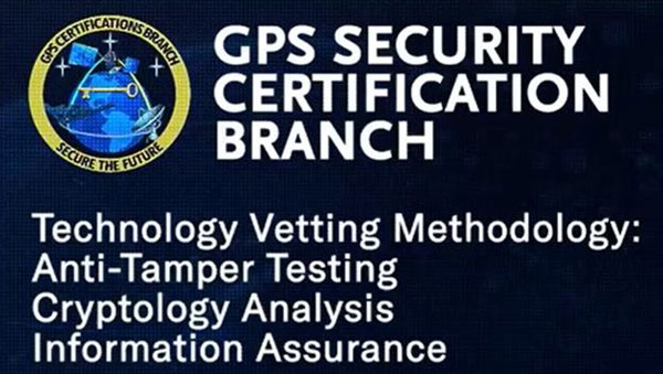
The United States Space Force’s Space Systems Command (SSC) has a specialized branch responsible for certifying GPS accuracy called the GPS Certification Branch. It is a specialized team within SSC that is responsible for certifying the hardware, software, and firmware used in GPS-based systems.
The certification process conducted by SSC’s GPS Certification Branch involves the evaluation of design and testing for various components of GPS-based systems. This includes user equipment — the devices used by individuals or organizations to receive GPS signals and determine their precise location.
The GPS Certification Branch works with GPS manufacturers, agencies of the U.S. Department of Defense (DOD), and others to establish and maintain certification standards. Collaboration with industry experts, research institutions, and other certification bodies is also an important aspect of the branch’s work to stay informed about technological advancements and ensure the certification process remains up to date with the latest developments.
The certification process also includes space segments — the satellites that transmit the GPS signals, monitoring stations, which track and monitor the performance of the GPS satellites, and the terrestrial modules — that provide end user secured and accurate signals.
Certification of hardware, software, and firmware is critical to ensure that GPS systems meet the standards set by the DOD. This certification ensures that the GPS-based systems used by the military and other DOD agencies are reliable, accurate, and secure. It also ensures that they are interoperable and compatible with other military equipment and communication networks.
The assessment process conducted by the GPS Certification Branch involves thorough testing and analysis of the design, performance, and security of the GPS components. This includes assessing the hardware’s ability to receive and process GPS signals accurately, the software’s ability to interpret and utilize the GPS data effectively, and the firmware’s ability to maintain system integrity and security.
Space Systems Command (SSC), the National Reconnaissance Office (NRO), United Launch Alliance (ULA) and their mission partners successfully launched the “Silent Barker”/NROL-107 mission aboard an Atlas V rocket September 10, 2023, at 8:47 a.m. EDT from Space Launch Complex (SLC)-41 at Cape Canaveral Space Force Station, Florida.
The spacecraft was part of the Space Force’s Silent Barker satellite constellation network intended to provide space situational awareness, orbital surveillance and tracking.
According to a statement by ULA, Silent Barker is designed to detect and maintain custody of space objects. This capability enables indications and warnings of threats against high-value assets in geosynchronous orbit.
The mission aims to serves the needs of the U.S. Department of Defense and intelligence community by providing the capability to search, detect and track objects from a space-based censor for timely custody and event detection, the company said.
Surveillance from space allows the government to overcome existing ground sensor limitations and will enable the collection of timely satellite metric data around the clock.
One more Atlas V 551 remains in the NSSL inventory as the Space Force approaches the end of Atlas.
Space Systems Command (SSC) has successfully delivered the second and final spaceflight-ready payload to Japan, bolstering the contribution by the U.S. Space Force (USSF) to integrated deterrence in the region.
The two USSF payloads, developed by MIT Lincoln Laboratories, will be hosted on Japan’s GEO-based Quasi-Zenith Satellite System (QZSS). The deliveries of both payloads to Japan follows a Memorandum of Understanding signed between the two nations in December 2020.
This effort aims to demonstrate the ability of the U.S.-Japan alliance to extend to space; contribute toward the Department of Defense’s broader integrated deterrence posture against shared adversaries in the Indo-Pacific theatre; contribute to the USSF’s Space Domain Awareness; and provide a basis for future opportunities with international partners.
The hosted payloads will augment the USSF’s ability to conduct persistent, time-dominant volume search at geosynchronous orbit. Launch dates for the host satellites, QZS-6 and QZS-7, have not yet been announced.
The Resilient Missile Warning, Missile Tracking, and Missile Defense Acquisition Delta of the U.S. Space Force’s Space Systems Command (SSC) has released a request for information (RFI) seeking industry inputs for the next Epoch of medium-Earth-orbit missile warning and tracking (MW/MT) satellites. Responses from industry are requested by no later than May 16.
A continuation of the Missile Track Custody (MTC) Program, Epoch 2 is the second increment of capability-based, phased deliveries that leverage a mature foundation of space system technology — which allows for the insertion of new technology. Resilient MW/MT Epoch 2 satellites and associated ground systems will provide next-generation overhead persistent infrared solutions to defeat advanced missile threats.
The RFI solicits feedback from industry on the Epoch 2 acquisition strategy and technical approach for a multi-plane space segment, integrated ground segment and constellation-level systems operations.
Epoch 2 will emphasize the maturation of MW/MT sensors, optical cross-links, data fusion, constellation mission management and robust ground communications.
For more information on receiving the full Epoch 2 RFI can be found on the SAM.gov website linked here.
GPS is the gold standard for precise positioning, navigation, and timing (PNT), impacting the lives of more than six billion users worldwide. The United States economy alone depends on the free, government-provided service across 900 million GPS receivers supporting vehicle navigation systems, general aviation, financial transactions, the electrical grid, precision agriculture, surveying and construction. The GPS enterprise must remain consistent and reliable, while keeping pace with emerging technology without interruption for the end user.
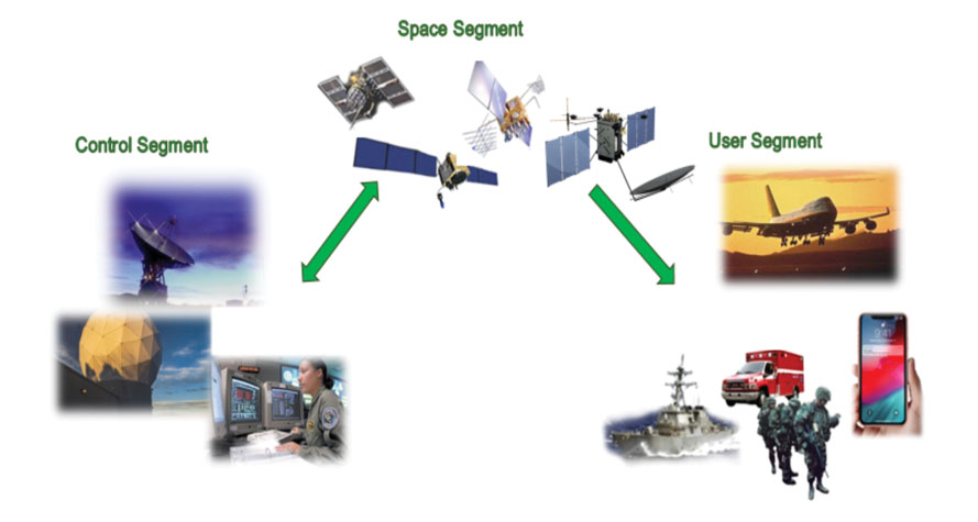
Space Systems Command (SSC) at Los Angeles Air Force Base in El Segundo, California — the U.S. Space Force’s space development, acquisition, launch and logistics field command — is responsible for maintaining and modernizing the GPS enterprise. The enterprise consists of three segments: the space segment, the control segment and the user segment. Each achieved specific milestones during an exciting and productive 2022.
A new MGue for warfighters is moving closer to completion. (Image: EvgeniyShkolenko/iStock /Getty Images Plus/Getty Images)
Space Segment
There are currently 37 GPS satellites on-orbit with 31 set healthy. The constellation requires 24 operational satellites for worldwide coverage and a receiver needs to receive transmissions from four of them to determine its position in three dimensions. GPS continues to operate impressively with an average 45-cm accuracy throughout the past year with the most precise day on record at 31.5 cm. The space segment of GPS modernization focuses on GPS III and GPS IIIF satellite development with significant milestones rounded out in 2022.
For GPS III, after the successful launch of Space Vehicle 5 (SV05) on June 17, 2021, it was set healthy (usable) on May 25, 2022. The significance of SV05 is its full operational capability of the improved civilian L2 (L2C) signal. L2C improves service speed for commercial users via access to two frequencies, improves accuracy when combined with legacy civil GPS signals (L1 C/A), and is less susceptible to ionospheric interference. SV05 is the 24th satellite enabled with the Military Code (M-code), providing worldwide M-code coverage. M-code is designed to give military receivers better defense against jamming, improved accuracy, a more secure and flexible cryptography architecture, and the ability to detect and reject false signals.
On Jan. 18, 2023, SV06 successfully launched into orbit aboard a SpaceX Falcon 9 Block 5 rocket from Cape Canaveral Space Force Station, Florida. The launch of SV06 marks a key step in the larger goal of modernizing the GPS constellation. Additionally, the 10th and final satellite in the GPS III fleet finalized production and has a target launch date of 2026. GPS III Space Vehicles 7–10 are in storage and available for launch.
The next generation of GPS satellites continues development. The October 2022 contract award for GPS III Follow-On (GPS IIIF) satellites will onboard additional capabilities. In addition to introducing new civil signals designed to enhance search-and-rescue efficacy and aviation safety, laser retroreflector array for precise ranging, and a fully digital navigation payload, the GPS IIIF satellites will offer a new Regional Military Protection (RMP) capability providing up to 60 times greater anti-jamming measures. A new port on the Lockheed Martin LM2100 Combat Bus supports a substantial increase in flexibility, providing rapid integration of payloads in response to emerging threats in space.
GPS Enterprise interrelated segments. (Image: Space System Command)
Control Segment
The Next Generation Operational Control System (OCX) will replace the current GPS Operational Control System (OCS), supporting the latest U.S. Department of Defense standards and practices for cybersecurity. The updated system includes a modernized and expanded monitor station network, improved anti-jam capabilities, and enhanced operational capability to control modernized military signals.
In March 2022, OCX completed its fourth and final legacy ground antenna element (LGAE) installation on Kwajalein Island in the Republic of the Marshall Islands. OCX Block 1 and 2 are undergoing Hewlett Packard (HP) Formal Qualification Test (FQT). This event will qualify much of the system’s previously certified mission software functions. The event will also demonstrate system maturity and readiness for system acceptance, operator training, and specific developmental testing milestones with both GPS space and user segments.
The next-generation control system, OCX 3F, will modify OCX Blocks 1 and 2 to use the enhanced capabilities of GPS IIIF satellites. OCX 3F received Milestone B and Acquisition Program Baseline (APB) approval from the Milestone Decision Authority (MDA) and was authorized to enter the Engineering and Manufacturing Development (EMD) phase in May. In November, the OCX 3F program deployed 3F mission software into OCX’s Near Operations Environment (NOE) for the first time after completion of the program’s first Integration Readiness Review (IRR). The IRR event ensures that the software meets integrity standards and receives approval to be integrated and tested on the NOE prior to software releases to the operational users. OCX 3F anticipates achieving operational acceptance in 2027.
The GPS III government and industry team recently core mated GPS III SV10 and nicknamed it “Hedy Lamarr” after the actress and inventor. (Image: Lockheed Matin)
User Equipment Segment
Among the arsenal of GPS user equipment, very few pieces have the technology to use the M-code signal. Maintaining a competitive advantage against the adversary requires use of these signals; the GPS Enterprise is focused on developing Modernized GPS User Equipment (MGUE) capable of accessing these signals. The MGUE program is a joint service program developing modernized M-code-capable military GPS receivers. The program is broken into two increments (Inc 1 and Inc 2). Both are designed to deliver secure PNT performance, allow navigation warfare operations, enhance anti-jam, enhance anti-spoof and anti-tamper, and enable Blue Force Electronic Attack.
As part of the multiple elements under the MGUE Inc 1 umbrella, L3Harris delivered its final Build 7 ground card to the government on Nov. 16, 2021, and completed regression testing on that kit in February 2022. The final Delta Security Certification and Approval were completed on April 13 and April 29, 2022, respectively. Development of the L3H Ground-Based GPS Receiver Applications Module (GB-GRAM-M) card, which delivers geolocation and precise positioning capabilities for space-constrained applications while providing increased security and anti-jam capabilities, is complete and available for services procurement. MGUE Inc 1 completed qualification testing for the aviation and maritime cards on Sept. 9, 2022, with updated software builds. This build allows the program to progress to 98% of the requirements verified and enables B-2 Bombers and Guided Missile Destroyers (DDG) to continue progress toward operational testing. Completion of this commitment means significant progress toward operational testing for stakeholders and warfighters.
MGUE Inc 2 held Preliminary Design Reviews for the Miniature Serial Interface (MSI) in summer 2022, bringing the project another step closer to finalizing the EMD phase. Once all closure and action items are completed for the reviews, the government will consider each event complete. Critical Design Review (CDR) is scheduled for this summer and will validate the system design and the ability to meet system performance requirements. MGUE Inc 2 continues to execute the second competitive objective under Phase I for the Joint Modernized Handheld component; the effort is moving closer to completion of the handheld prototype and will ultimately make for a more seamless transition to operations.
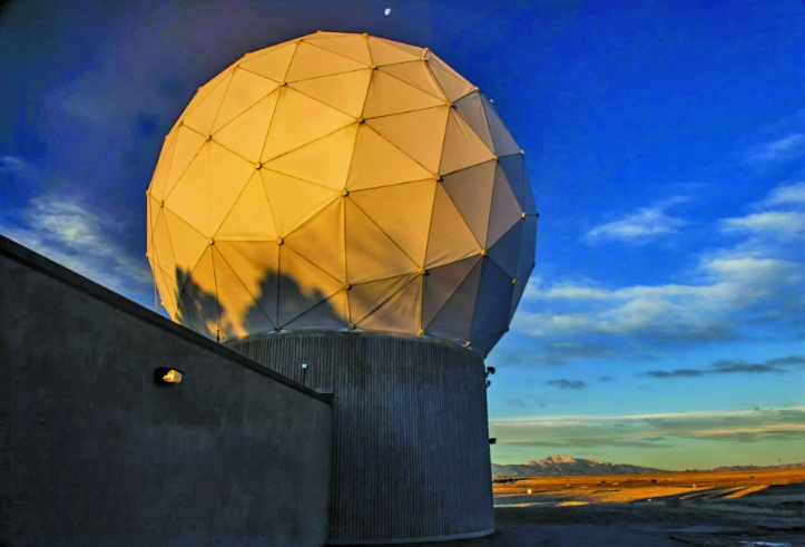
GPS ground antenna at Schriever Space Force Base in Colorado. (Image: U.S. Air Force)
Conclusion
The SSC’s mandate is paramount to maintaining our modern way of life. The space professionals dedicated to developing GPS technology are committed to delivering advanced capabilities to the warfighter, the civil sector, and the world. An interconnected world is ready for us. We’re on our way.
SSC is the U.S. Space Force field command responsible for acquiring and delivering the capabilities needed by warfighters to protect our nation’s strategic advantage in and from space. It manages an $11B budget for the U.S. Department of Defense and works in partnership with joint forces, industry, government agencies, academic and allied organizations to outpace emerging threats.
For analogous updates on the other three GNSS constellations, please see:
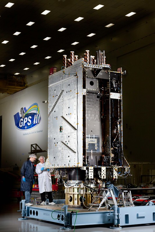
Space Systems Command (SSC) has declared GPS III Space Vehicle 10 (SV10) available for launch, marking completion of constellation modernization efforts and production for the GPS III program.
“The completion of the tenth, and final, GPS III space vehicle is a significant milestone for GPS modernization,” said Scott Thomas, GPS III program manager for the GPS Space Vehicles Acquisition Delta within SSC’s Military Communications and PNT directorate. “This would not have been possible without the collaboration, communication, and accountability of our industry and government partners. The GPS III program contributions underpin U.S. national security needs for our warfighters and for more than four billion GPS users worldwide.”
GPS III satellites deliver enhanced performance and accuracy through a variety of improvements, including increased signal protection with improved accuracy. GPS III also delivers a new L1C signal designed for interoperability with similar GNSS, and expands the civilian L5 signal, dubbed safety-of-life, which is not yet operational.
GPS III SV06 was launched on a SpaceX Falcon 9 Block 5 vehicle on Jan. 18, and Operational Acceptance was declared on Jan. 31. GPS III SV07, SV08, SV09 and SV10 are awaiting launch at Lockheed Martin’s GPS III processing facility in Waterton, Colorado.
GPS III Space Vehicle 06 (SV06) reached Operational Acceptance on Jan. 31 according to the Space Systems Command (SSC) of the United States Space Force. SV06 was launched on a SpaceX Falcon 9 Block 5 vehicle on Jan. 18.
SSC also transferred Satellite Control Authority (SCA) of SV06 to the 2nd Space Operations Squadron at Schriever Space Force Base, Colorado. GPS III SV06 joins the GPS PNT constellation of 31 operational satellites.
This is the first time SCA and Operational Acceptance has occurred on the same day enabling faster delivery for users. SSC’s Military and Communication positioning, navigation and timing (PNT) enterprise collaborated with the U.S. government acquisition team, industry and space operators on the achievement.
“The Operational Acceptance of GPS III SV06 further contributes to SSC’s ongoing modernization efforts, as it brings our overall suite of capabilities ever closer to our target dates for deployment to the warfighter,” said Col. Heather J. Anderson, transition director within SSC’s PNT directorate. “GPS III SV06 will be set healthy to all global users in February 2023.”
The first-stage booster used in the SV06 launch previously sent the NASA Crew-5 mission to the International Space Station on Oct. 5, 2022.
The U.S. Space Force (USSF) has delivered two payloads to Japan for the Quasi-Zenith Satellite System (QZSS). The payloads will be integrated into two QZSS host satellites being prepared for launch, which will expand the QZSS constellation from five to seven satellites.
The QZSS hosted payload (QZSS-HP) is central to the USSF priority of expanding cooperation to contribute to international security. The mission is managed by the Space Domain Awareness and Combat Power Directorate (SDACP) of the Space Systems Command (SSC) within the USSF.
Massachusetts Institute of Technology’s Lincoln Laboratories (MIT/LL) is the primary payload developer for the QZSS-HP. MIT/LL and USSF personnel will travel to Japan to support the integration and test efforts with Japanese partners until both QZSS host satellites are launched.
Modernized communications lines were installed at seven locations worldwide in an overhaul of the global communications network that provides command and control of the GPS constellation.
Kwajalein Atoll in the Marshall Islands is one of seven locations that received a GPS communications network overhaul.(Photo: USGS)
From 2018 to 2022, GPS Product Support Delta — in conjunction with the Defense Information Systems Agency (DISA) — performed a complete overhaul of the global communications network required to provide command and control of the GPS satellite constellation. GPS Product Support Delta is under Space Systems Command of the U.S. Space Force.
The project, called GPS Operations Network Enhancements (GONE), connected multi-protocol label switching internet protocol (IP)-based routers to modernized communications lines at seven key GPS facilities, replacing older serial lines.
“With the GONE project completed, we are seeing a 75 percent reduction in communication line interruptions.”
The GONE initiative “has significantly enhanced communications for GPS weapon systems,” said Brian Botka, Product Support Delta GPS program manager.
“These upgrades not only increase communications speed and reduce overall down-time and adding a new paradigm in network resiliency with the networks capable of recovering in mere seconds from an outage or issue,” said Sean Foley, DISA technical project manager. “The system upgrades will continue to improve service to the warfighter as well as enable increased resiliency and network diversity for DISA.”
The modernized communications lines were installed at
Schriever Space Force Base, Colorado
Vandenberg SFB, California
Cape Canaveral Space Force Station, Florida
Facilities in Hawaii, Ascension Island, Diego Garcia and Kwajalein Atoll.
Throughout the COVID-19 pandemic, many of these locations were under strict lockdown or required long quarantine periods, making coordination and travel to remote locations more challenging.
Lockheed Martin was the contractor who supported Product Support Delta GPS on the GONE project. “This was a collaborative effort with Product Support Delta GPS and DISA that required significant logistical efforts due to the COVID-19 pandemic,” said Christina Mancinelli, Lockheed Martin GPS Ground Programs director.
“With the GONE project completed, we are seeing a 75 percent reduction in communication line interruptions, and we expect that metric to continue to improve,” Mancinelli said. “The migration of the GPS communication lines to the modern MPLS [multiprotocol label switching] routers and Ethernet-based connections continues the significant improvements in GPS ground capability, cybersecurity and reliability.”
SSC is the USSF field command responsible for rapidly identifying, prototyping, and fielding resilient space capabilities for joint warfighters. It delivers sustainable joint space warfighting capabilities to defend the nation and its allies while disrupting adversaries in the contested space domain.
SSC mission areas include launch acquisition and operations; space domain awareness; positioning, navigation, and timing; missile warning; satellite communication; and cross-mission ground, command and control and data.
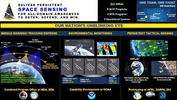
New Combined Program Office to enhance U.S. ability to prevail against threats in space, including new hypersonic weapons
Space Systems Command (SSC) is leading a new tri-agency Combined Program Office (CPO) comprised of representatives from SSC, the Space Development Agency (SDA) and the Missile Defense Agency (MDA). The CPO was established on Aug. 19 to enhance the United States’ ability to deter, defend and win against competitors’ challenges in space.
The Space Acquisition Council, established by Congress to manage space procurements across the Department of Defense, concurred on the CPO proposal, enabling the coordinated development and fielding of capabilities in the missile warning (MW), missile tracking (MT), and missile defense (MD) mission areas.
The CPO will address growing challenges resulting from the transition of space from a peaceful domain to one that is congested, contested and competitive. Other nations now challenge access to and movement in space, and have demonstrated the capability and intent to hold U.S. and allied space assets at risk.
“The MW/MT/MD mission is driving the U.S. Space Force’s new ‘requirements to execution’ roadmap, rapidly turning USSF Force Design into operational capabilities that will outpace and defeat very determined threats,” said U.S. Space Force Col. Brian Denaro, Space Sensing program executive officer and leader of the new CPO. “Our adversaries continue to develop missile technologies that are faster burning, dimmer and more maneuverable. This Combined Program Office, in partnership with SDA and MDA, will drive critical integration across a new resilient multilayer architecture that will warn, track and defeat these increasingly advanced and elusive missile threats.”
Establishing this partnership among MW/MT/MD acquisition organizations will enhance the interface between requirements, operators and users, optimizing delivery of integrated and resilient sensor-to-shooter capabilities for the United States and its allies.
“We are focused on delivering MW/MT/MD capabilities to the warfighter and the nation,” said U.S. Army Lt. Col. Alexander Rasmussen, Tranche 1 Tracking Layer program manager, SDA. “The Combined Program Office is a critical component in delivering this capability and enabling our nation to counter hypersonic and advanced missile threats. Together, SDA, MDA and SSC will ensure a synchronized end-to-end capability that sets the foundation for a continually evolving and advancing MW/MT/MD architecture.”
“With the emerging advanced threats, space-based sensors are essential to missile defense,” said Walter Chai, director for space sensors at MDA. “The close collaboration between SDA, SSC and MDA will ensure that we are able to defeat these threats.”
The CPO organizational structure integrates strategic decision-making across the interagency, establishing:
clear roles, responsibilities, and authorities for SSC, SDA, MDA and other mission partners
end-to-end system of systems accountability between requirements and weapon system delivery
development and management of standards (models, open architecture, data, etc.)
integration with operators, combatant commands and other weapon systems.
Space Systems Command is the U.S. Space Force field command responsible for rapidly identifying, prototyping and fielding resilient space capabilities for joint warfighters. SSC delivers sustainable joint space warfighting capabilities to defend the nation and its allies, while disrupting adversaries in the contested space domain. SSC mission areas include launch acquisition and operations; space domain awareness; positioning, navigation and timing; missile warning; satellite communication; and cross-mission ground, command and control, and data.
China will lose access to a strategic space tracking station in Western Australia when its contract expires, a decision that could affect BeiDou constellation service in the Pacific region, according to a Reuters report.
A contract between the Swedish Space Corp. (SSC) and China has given Beijing access to a station antenna since 2011, but the SSC satellite station is primarily used by the United States and its agencies.
The Swedish state-owned company told Reuters it wouldn’t enter into any new contracts at the Australian site to support Chinese customers after its current contract expires, but did not disclose the exact date.
Ground stations are a vital part of space programs given they create a telecommunications link with spacecraft. While stations have different capabilities, they can be equipped to coordinate satellites for civil-military GNSS such as Beidou, Russia’s GLONASS, the European Union’s Galileo system, and U.S.-owned GPS.
China’s space program has been increasing its access to overseas ground stations in recent years in line with the expansion of its space exploration and navigational programs.
“Generally speaking, anywhere you put a GNSS monitoring ground station will improve the accuracy of positioning for that region,” said Joon Wayn Cheong, a senior research associate at the University of New South Wales’ School of Electrical Engineering.
China wants to remove its dependence on GPS as part of broader plans to expand its global influence, says Christopher Newman, professor of Space Law and Policy at Northumbria University in Newcastle, England. “GPS could be made unavailable to them in a military conflict. An independent secure system is crucial for the capabilities of the People’s Liberation Army [China’s military] with respect to targeting, weapons, navigation,” he told Reuters.
Beijing last year reestablished diplomatic ties with the small Pacific island nation of Kiribati, where it has a mothballed ground station.