STMicroelectronics (ST) is making its Teseo III satellite navigation receiver accessible to a wider designer community by introducing the Teseo-LIV3F module, which integrates essential features to speed application development and also adds up to 16 MB of Flash memory for firmware updating or data logging without a backup battery.
Used by automotive and industrial sectors, ST’s Teseo III multi-constellation receiver combines high accuracy with fast response time and low power consumption, the company said.
The Teseo-LIV3F module now enables makers and small engineering teams without extensive in-house RF expertise to leverage the Teseo III advantages in creating new products in the industrial and consumer market segments such as vehicle trackers, drones, anti-theft devices and pet locators, and systems for services such as fleet-management, tolling, vehicle sharing or public transportation.
The 18-pin, 9.7 x 10.1 millimeter module contains the Teseo III receiver with on-chip power management, UART and I2C interfaces, alongside the Flash memory, an ultra-stable temperature-controlled crystal oscillator (TCXO), and 32kHz real-time clock (RTC).
The documentation and tools delivered with the module contain all the C code needed to drive the module using the STM32 microcontroller, including the use of data-logging, odometer and geofencing to aid development of value-added functionality.
While simplifying application development, Teseo-LIV3F delivers high performance, including -163 dBm tracking sensitivity and 1.5m positioning accuracy (CEP Circular Error Probability) and low-power operation (17µW in standby mode and 75mW when tracking). FCC and CE certifications streamline product testing and accelerates time to market.
Multi-constellation flexibility ensures robust, failure-resistant navigation worldwide, with access to the GPS, GLONASS, Galileo and BeiDou constellations, as well as the Pacific-region Quasi-Zenith Satellite System (QZSS).
The module supports assisted modes — including autonomous ST Assisted GPS (STAGPS) and server-based assisted-GNSS with free server access — to retrieve ephemeris data if satellites are unavailable for fast time to first fix (TTFF). The module also supports standardized augmentation systems to enhance accuracy, including the U.S., European, Japanese/South-East Asia, and Indian Satellite-Based Augmentation Systems (SBAS), and the Radio Technical Commission for Maritime Services (RTCM) differential GPS.
The Teseo-LIV3F module is available now as an 18-pin LLC device.
The tools connect directly to TomTom Maps APIs (Application Programming Interfaces) for location, tracking and mapping data services, accelerating product development, and reducing time-to-market and development costs for developers, the companies said.
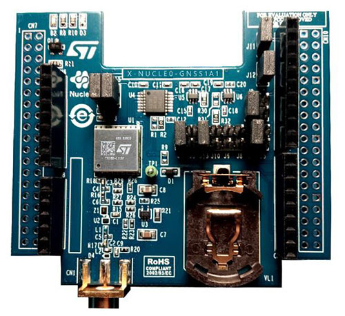
The X-NUCLEO-GNSS1A1 expansion board is based on the Teseo-LIV3F tiny GNSS module. (Photo: STMicroelectronics)
The development package consists of an STM32 Discovery host board for 2G/3G cellular-to-cloud connectivity, a GNSS expansion board based on ST’s Teseo satellite navigation technology, and a software Function Pack that connects an internet-of-things (IoT) node via a cellular network to a range of TomTom Maps APIs.
With this hardware and software package and a TomTom developer account, developers can quickly add location-based services to their IoT and smart city applications.
Among these services are the translation of GPS coordinates into a street address inside a map (Reverse Geocoding), retrieval of nearby point of interests, and the production of accurate navigation directions.
“We have combined TomTom’s industry-leading location-based and mapmaking technologies with ST’s unrivaled combination of silicon and system expertise to create a unique offering that provides easy access to TomTom’s Maps APIs to empower developers to create groundbreaking, location-aware applications faster and more efficiently,” said Anders Truelsen, managing director of TomTom’s Enterprise Business Unit.
“Supporting our efforts to facilitate location-based product development, our collaboration with TomTom has built on each company’s strengths to assemble a tailored package of hardware and software tools that is already fully integrated with TomTom cloud services, around the popular STM32 development ecosystem,” said Alessandro Cremonesi, group vice president at STMicroelectronics. “These tools enable native STM32-based location services to accelerate application development of Geo-IoT solutions for fleet management, item tracking, and many other services that depend on fast, accurate location detection.”
In addition to the STM32 family of Arm Cortex-M core microcontrollers, the development tools leverage ST’s market-proven multi-constellation Teseo positioning-receiver technology to perform all positioning operations including tracking, acquisition, navigation and data output.
A roundup of recent products in the GNSS and inertial positioning industry from the August 2018 issue of GPS World magazine.
OEM
IP Solution
With multi-constellation GNSS for internet of things (IOT) devices
The Dragonfly NB2 is a highly integrated and modular IP (internet protocol) solution optimized for Cat-NB2 (3GPP Release 14 eNB-IoT) that can seamlessly be incorporated into chips and modules by the multitude of companies looking to address the large and fast-growing cellular IoT space. GNSS hardware package. For customers developing NB-IoT products that also require GNSS capabilities, Ceva-Dragonfly NB2 includes a new power-optimized GNSS hardware package, with GNSS RF receiver and multi-constellation digital front-end. The GNSS package speeds up both acquisition and tracking tasks by up to 8 times compared to Ceva-Dragonfly NB1, enabling a host of popular NB-IoT use cases, including people, livestock and asset tracking and geofencing.
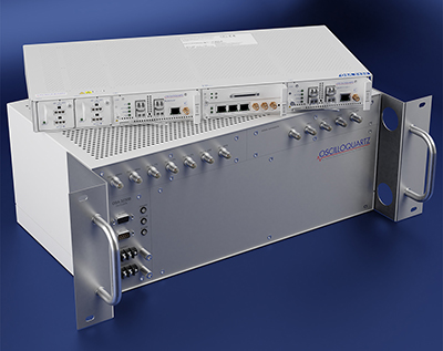
Provides timing accuracy and stability when GNSS signal is lost
Photo: Oscilloquartz
Oscilloquartz has launched its enhanced primary reference time clock (ePRTC) system to enable a high level of timing accuracy and stability, even when the GNSS signal is lost. The system provides a timing source for mission-critical transport systems, such as utility networks, government infrastructure and radio access networks, and provides the strict synchronization needed for LTE-A and 5G applications. Featuring the OSA 3230B ePRC atomic cesium clock connected to an Oscilloquartz clock combiner and grandmaster, the new solution offers the extremely stable frequency of a cesium clock with the UTC-traceable signal provided by GNSS. When combined with the OSA 5430, the OSA ePRTC system provides full hardware redundancy and multiple fan-out options including PTP over 10 Gbit/s.
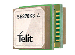
The SE878Kx-A series of GPS and GNSS integrated antenna receiver modules offer high performance, maximum reliability and low power consumption for consumer and business applications. The SE878K3-A and SE878K7-A are compatible with GPS, GLONASS, Beidou and Galileo and also enable device vendors to develop quickly and cost-effectively location-based IoT solutions for use in virtually any country worldwide. The SE878Kx-A series supports dual internal-external antennas to ensure connectivity when one is broken or compromised, along with a SAW filter to maximize jamming immunity. The modules are designed for mission-critical applications and other use cases where reliability is key, such as alarms, stolen cars or high-end asset tracking. The series also provides seamless integration with Telit’s cellular modules, including eCall/ERA-GLONASS compliant solutions.
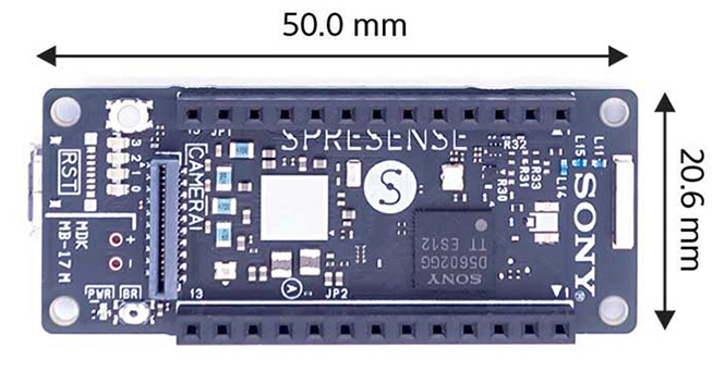
The Spresence main and extension boards are designed for internet of things (IoT) applications. The main board uses a multi-CPU structure equipped with Sony’s GNSS receiver (GPS+GLONASS) and high-resolution audio codec. A variety of systems for applications such as drones and other IoT devices can be built by combining the boards and developing the relevant applications. The boards’ software and hardware is available via open platform, allowing for a wide range of developmental possibilities. The main board can be used to control a drone using GPS positioning and a high-performance processor, voice-controlled smart speakers and low-power consumption sensing cameras. It also can be combined with sensors for use in systems that detect errors in production lines on the factory floor.
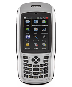
Designed for geopositioning, construction and mapping
Photo: Topcon
The T-18 handheld controller has a 3.7-inch sunlight-readable display, a 1-GHz processor and 1 GB of internal storage. For field data collection using Topcon’s MAGNET software, the T-18 offers a durable ergonomic solution with fast processing, excellent connectivity and a long (10-hour) battery life. It has a 3.5G cellular modem for connectivity with Topcon MAGNET solutions for sending and receiving data to the cloud company account. The modem also can be used for real-time kinematic (RTK) correction services. Other features include Bluetooth and an IP65 rating for dust and water protection in demanding job-site conditions.
The SXblue ToolBox is an Android application for SXblue GNSS receivers, enabling users to view and analyze the position data and metadata related to its location. The user can send commands that enable or disable some features, including systems in use, mask angle or differential angle, and constellation in use, including GPS, GLONASS, Galileo, BeiDou and SBAS. The SXblue ToolBox is also an NTRIP client capable of connecting to a NTRIP server for real-time kinematic (RTK) corrections, allowing the receiver to issue very accurate location information. The application can record, save and transfer raw data from the GNSS receiver, allowing post-processing on computers for surveying and geomatics professionals.The toolbox has been developed with special consideration for modern mobile devices and attention to user and dealer feedback. It includes a series of configurable audible and visual alarms for determining the thresholds of the information provided by the SXblue GNSS receiver.
The Leica RTC360 laser scanner is equipped with edge computing technology to enable fast and accurate creation of 3D models in the field. It combines high-performance laser scanning, edge computing and mobile app technologies to preregister captured scans quickly and accurately. With the push of a button, two million points per second of high dynamic range imagery can be captured to create a full-dome scan in under two minutes. It features a visual inertial system that automatically tracks movements between setup positions. The scans captured can be combined and preregistered on a mobile device, where they can be viewed and augmented with information tags.
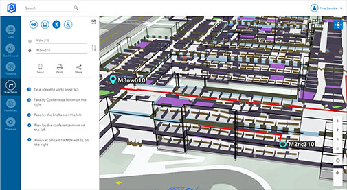
Location technology allows users to see rooms, gates and offices
Screenshot: Esri
ArcGIS Indoors is designed to enable interactive indoor mapping of corporate facilities, retail and commercial locations, airports, hospitals, event venues, universities and more. The solution applies the latest location technology to allow users to see and share where assets, rooms, departure gates and offices are located. It uses data streams, real-time processing and location intelligence tools to help businesses and other organizations understand how to better coordinate space and other resources with their facilities and campuses. Insights from sensor networks deliver real-time information to managers and executives through interactive dashboards, while visitors and employees can find useful information about the buildings they occupy. The solution also allows users to quickly access and explore critical business information, such as the location and status of fire extinguishers and their last inspection dates.
Meets demands for continuous, accurate vehicle location
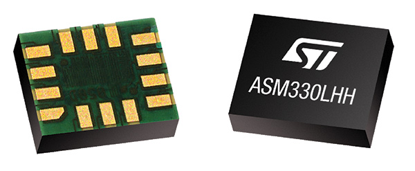
The ASM330LHH module. (Photo: STMicroelectronics)
The automotive-grade ASM330LHH six-axis inertial sensor is designed for super-high-resolution motion tracking in advanced vehicle navigation and telematics applications. It lets advanced dead-reckoning algorithms calculate precise position from sensor data if satellite signals are blocked, such as in urban canyons, tunnels, covered roadways, parking garages or dense forests. Its advanced, low-noise, temperature-stable design enables dependable telematics services such as e-tolling, tele-diagnostics and e-Call assistance. Precision inertial data in six axes also meets the needs of advanced automated-driving systems. Automotive component manufacturer Magneti Marelli has selected the ASM330LHH for advanced telematics systems, to be fitted as original equipment by global automotive groups in upcoming vehicle ranges.
Esri and Waze smart cities partnership grows. (Image: Esri)
The free crowdsourced traffic and navigation app Waze is now fully supported by ArcGIS Online, where its live feed of mapped traffic alerts and other information, such as accidents, congestion and street damage, can be used in applications in minutes. Waze Live Alerts, available in ArcGIS Marketplace, is free to members of the Waze Connected Citizens Program. The program, a two-way sharing of publicly available traffic and road condition information, offers governments a stream of data, constantly updated in real time. This enables personnel to make data-driven infrastructure decisions and improves the efficiency of incident response.
Traffic engineers can use the data to analyze problems on the road and create targeted solutions.
Open-source platform for autonomous delivery and other iot
The AGL platform provides Mercedes-Benz Vans with the ability to create autonomous delivery robots. (Image: Daimler)
Automotive Grade Linux (AGL) is a collaborative cross-industry effort to develop an open platform for the connected car. Mercedes-Benz vans are using AGL as a foundation for a new onboard operating system for its commercial vehicles. The Mercedes-Benz “adVANce” initiative focuses on connectivity and internet of things (IoT) applications, innovative hardware solutions, new on-demand mobility and rental concepts, and fleet management solutions. The AGL platform provides Mercedes-Benz Vans with the flexibility to rapidly create tailored solutions for customers, including adding and connecting any kind of IoT component to the vehicle, such as sensors, automation controls and actuators. The new AGL-based operating system will debut on various Mercedes-Benz Vans prototype projects later this year.
eCyber is an integrated hardware-software product that protects vehicles against ransomware and other cyber-attacks. It can be installed in a vehicle by authorized parties, such as vehicle importers and fleet managers, in the aftermarket stage after the vehicle has left the factory, as well as by the OEM itself during manufacture. eCyber, a combined hardware and software solution in a compact box, is installed between the vehicle’s external communications device and the vehicle’s CAN (Controller Area Network) bus. It provides a secure gateway for outside communications to the CAN bus, allowing only communications with predefined parameters and values to go through. It blocks any unrecognized communications to and from the CAN bus, so no malicious digital communications can disrupt vehicle function.
Engineered for UAV-imaging missions, the iXM 100MP is a high-productivity metric camera with a range of high-resolution lenses. It is ready for integration with various UAV platforms, including Phase One’s DJI Matrice 600 Pro. The camera incorporates a medium-format sensor with backside-illumination technology, enabling high light sensitivity and extended dynamic range. Phase One also offers four new RSM lenses — with focal lengths ranging from 35mm to 150mm — to fit the new sensor’s 3.76 μm pixel size and 33 x 44 mm frame size. The lenses are available with either fixed-focus or motorized-focus functionality. The fixed-focus 35mm and 80mm lenses are especially suitable for surveying applications.
For quick approval of flights over controlled airspace
Screenshot: Skyward
Commercial drone operators in California and Hawaii — as well as a few areas in Nevada, Utah and Arizona — can get quickly authorized to fly in controlled airspace using the LAANC (Low Altitude Airspace Notification Capability) platform. Skyward is an FAA-approved airspace vendor. With Skyward, pilots with a Part 107 license can get permission to fly in regulated airspace in seconds compared to manual authorizations that can take months. This makes it significantly easier for businesses of all sizes, particularly in the construction and warehousing industries, to manage a fleet of drones to access valuable, cost-saving data. Skyward’s LAANC expansion includes airspace in the busy metro areas of Los Angeles, the Bay Area, San Diego, Las Vegas and more than 50 smaller air markets.
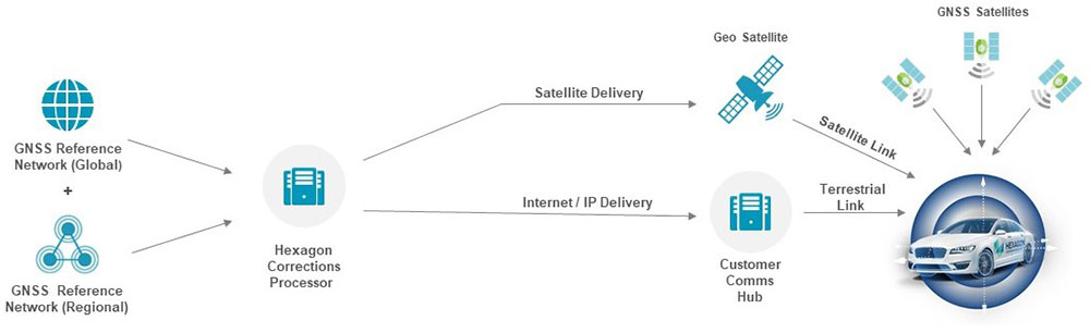
GNSS positioning algorithms combined with automotive-grade GNSS chipsets, inertial measurements and GNSS corrections services from a ground network of reference stations can deliver instant lane-level accuracy.
By Tasha Wong Ken and Sara Masterson, Hexagon Positioning Intelligence
Autonomous technology is reshaping the future of the automotive industry and Hexagon’s Positioning Intelligence Division (Hexagon PI) is developing cutting-edge positioning solutions to support the growth of this rapidly changing industry.
Hexagon PI is working with GNSS chipset manufacturers like STMicroelectronics to deliver automotive-grade, multi-frequency GNSS chipsets that combine our positioning algorithms with automotive-grade GNSS hardware to deliver solutions for connected cars, advanced driver-assistance systems (ADAS) and autonomous driving applications.
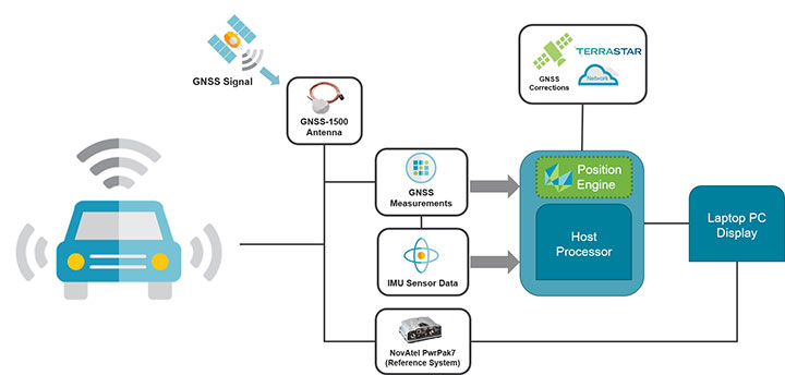
In June, Hexagon PI introduced TerraStar X GNSS correction technology, which enables lane-level vehicle positioning in under a minute, using automotive-grade chipsets and the Hexagon PI positioning engine. Built on the company’s latest precise point positioning (PPP) algorithms, TerraStar X leverages existing Hexagon capabilities in ground network infrastructure, correction data generation, and data packaging for delivery.
FIGURE 1. TerraStar X correction data generation and delivery to the vehicle. (Image: Hexagon PI)
By combining Hexagon PI’s software positioning engine with GNSS measurements from automotive-grade chipsets and inertial measurement unit (IMU) data, TerraStar X GNSS correction services can deliver instant lane-level accuracy positioning.
TerraStar X combines existing TerraStar global clock and orbit data with regional ionospheric correction data from Hexagon’s vast network of SmartNet reference stations. This forms the technology foundation for future correction services on connected cars, ADAS and autonomous driving markets, including integrity and authentication for safety-critical applications.
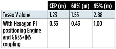
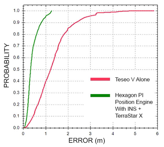
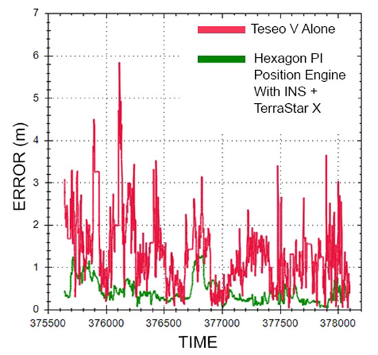
FIGURE 2. The Hexagon PI positioning engine achieves seamless position accuracy by taking GNSS measurements from the Teseo V GNSS receiver, combining it with their positioning algorithms, GNSS+INS coupling, and TerraStar X correction technology. (Image: Hexagon PI)TABLE 1. Cumulative distribution of horizontal errors from testing on German roads. (Table: T. W. Ken and S. Masterson)
HxGN SmartNet consists of a large operational reference station network, consisting of more than 4,500 stations with continuous quality monitoring and support. Correction data generation takes place at Hexagon processing centers where service reliability, redundancy and 99.999% guaranteed service uptime ensure corrections are available for users 24/7/365.
While TerraStar X utilizes the stations already available, the algorithms are flexible and will accommodate the rollout of new service areas with increased station separation, enabling continental-scale coverage.
TerraStar X technology will deliver correction data to vehicles and end users through hybrid delivery channels, including both cellular network and satellite. Combining TerraStar X technology with multiple delivery channels ensures that vehicles, UAVs, industrial vehicles, trains, and more will operate safely, securely, reliably, and efficiently.
TerraStar X testbeds are being utilized for several advanced automotive development programs in North America and Europe, TerraStar X commercial services will be available in 2019. Interested customers can request access to any of the testbeds through Hexagon PI.
Positioning Engine. Hexagon PI’s positioning engine architecture enables a flexible integration with different GNSS receiver chipsets, augmentation sensors and processor environments, providing automotive manufacturers with additional flexibility when it comes to sourcing components and subsystems of ADAS and autonomous driving solutions.
The positioning engine is being developed to Automotive Safety Integrity Level (ASIL)-B standards and will include a proprietary GNSS integrity solution to ensure safe positioning within defined protection limits tailored to the customer’s application requirements.
Recent test results
Hexagon PI conducted demonstrations in Michigan and Germany using an automotive platform that combined automotive-grade GNSS hardware with TerraStar X technology and the software positioning engine to demonstrate instant lane-level accuracy with correction data delivered over the cellular network to test vehicles.
The results are from the most recent demonstration performed in urban conditions in Germany. The route consisted of a mix of controlled-access highway and light urban roads in the city. In this case, the positioning engine using TerraStar X and GNSS+INS coupling deliver 1-meter accuracy through 95% of the dataset.
FIGURE 3. Cumulative distribution of horizontal errors from tests on German roads. (Figure: T. W. Ken and S. Masterson)
Throughout the data collection, position accuracy improves by almost 70% when TerraStar X and the positioning engine is used. In some areas, it was found that the position solution can improve up to 95% with the Hexagon PI positioning solution over the standalone Teseo V, an automotive-grade GNSS receiver from STMicroelectronics.
FIGURE 4. Horizontal position errors from testing on German roads. (Figure: T. W. Ken and S. Masterson)
Looking ahead in automotive
Hexagon PI continues to demonstrate the benefits of precise positioning on automotive-grade chipsets using augmentation sensors, our positioning engine, and TerraStar X technology in a variety of environments worldwide. Our goal is to develop a solution for mass-production that provides accurate and functionally safe positioning to enable the advancement of autonomy in the automotive industry.
STMicroelectronics has introduced the automotive-grade ASM330LHH six-axis inertial sensor for super-high-resolution motion tracking in advanced vehicle navigation and telematics applications.
Photo: STMicroelectronics
Serving demands for continuous, accurate vehicle location to support automated services, the ASM330LHH lets advanced dead-reckoning algorithms calculate precise position from sensor data if satellite signals are blocked, such as in urban canyons, tunnels, covered roadways, parking garages or dense forests.
Its advanced, low-noise, temperature-stable design enables dependable telematics services such as e-tolling, tele-diagnostics and e-Call assistance. Precision inertial data in six axes also meets the needs of advanced automated-driving systems, the company said.
Automotive component manufacturer Magneti Marelli has selected the ASM330LHH for advanced telematics systems, to be fitted as original equipment by global automotive groups in upcoming vehicle ranges.
For the ASM330LHH, as with all its MEMS sensors, STMicroelectronics owns the entire manufacturing process, from designing the sensors, through wafer fabrication, packaging, test, calibration and supply. Full end-to-end control enables STMicroelectronics to create high-performing sensors and assure customers of a robust and responsive supply chain, with rigorous end-of-line quality screening, the company said.
“STMicroelectronics is the largest supplier of MEMS sensors for automotive non-safety applications, such as navigation and telematics,” said Andrea Onetti, Analog, MEMS and Sensors Group vice president at STMicroelectronics. “Our latest-generation inertial sensor, the automotive-grade ASM330LHH, enables precise positioning for safer, smarter driving.”
Engineering samples will be available for evaluation by the third quarter of 2018, and volume production will begin the following quarter.
Further technical information on the ASM330LHH
Temperature range up 105 degrees Celsius giving designers extra freedom to locate electronic controls in hot areas such as in smart antennas on the vehicle roof, or near the engine compartment.
Ultra low noise allows greater measurement resolution by minimizing integration errors when positioning is reliant on sensors only.
High linearity and built-in temperature compensation eliminate any need for external compensation algorithms over its operating range.
Lowest power consumption in class, with features for optimizing power management if battery usage becomes crucial.
Qualified according to AEC-Q100 automotive-grade robustness standard.
Built on STMicroelectronics’ proven, proprietary ThELMA MEMS process technology, which enables integration of both the three-axis accelerometer and three-axis angular-rate sensor (gyroscope) on the same silicon for optimum yield, quality, and reliability.
The electronic interface integrates the signal chain for both sensors on a single die using STMicroelectronics’ 130nm HCMOS9A technology.
Reference designs, as well as STMicroelectronics’ Teseo satellite-positioning modules and related software are available. The dead-reckoning algorithm included with the Teseo III GNSS-receiver chipset already supports the ASM330LHH to generate a high-accuracy output suitable for autonomous navigation.
Tiny, low-profile 3mm x 2.5mm x 0.83mm device for minimal impact on the size of any on-board module.
Packaged as a leadless Land Grid Array (LGA) device.
STMicroelectronics is offering new high-stability MEMS sensors for the Industrial Internet of Things (IIoT).
The new sensors, to be made available sometime this year, begin with the IIS3DHHC, a 3-axis accelerometer optimized for high measurement resolution and stability to ensure accuracy over time and temperature.
The IIS3DHHC targets precision inclinometers in antenna-positioning mechanisms for communication systems, Structural Health Monitoring (SHM) equipment for keeping buildings and bridges safe, and stabilizers or levelers for a wide variety of industrial platforms.
Its long-term accuracy and robustness are also suitable for high-sensitivity tilt and security sensors, as well as image stabilization in high-end digital still cameras (DSCs), the company said.
STMicroelectronics also provides what it calls “product longevity” to assure long-term availability of components in industrial equipment.
The IIS3DHHC has a full scale of ±2.5 g and is capable of providing the measured accelerations to the application through an SPI 4-wire digital interface.
The sensing element is manufactured using a dedicated micromachining process developed by STMicroelectronics to produce inertial sensors and actuators on silicon wafers.
The IC interface is manufactured using a CMOS process that allows a high level of integration to design a dedicated circuit which is trimmed to better match the characteristics of the sensing element.
The IIS3DHHC is available in a high-performance (low-stress) ceramic cavity land grid array (CC LGA) package and can operate within a temperature range of -40 degrees Celsius to +85 degrees Celsius.
Key Features of the IIS3DHHC
Included in the 10-year longevity program
3-axis, ±2.5 g full-scale
Ultra-low noise performance: 45 µg/√Hz
Excellent stability over temperature (<0.4 mg/°C) and time
16-bit data output
SPI 4-wire digital output interface
Embedded FIFO (depth 32 levels)
Embedded temperature sensor
12-bit temperature data output
High shock survivability
Extended operating temperature range (-40 °C to +85 °C)
ECOPACK, RoHS and “Green” compliant
“These high-quality industrial sensors leverage our investments in MEMS design and high-yield fabrication processes to deliver superior performance with low ownership costs for applications where the highest precision, repeatability and robustness are critical,” said Andrea Onetti, group VP and general manager, MEMS Sensors Division, STMicroelectronics. “We will continue to introduce new types of precision sensors for industrial applications in the coming months, covered by our 10-year longevity commitment, including combination sensors, specialized sensors and complete inertial modules.”
The IIS3DHHC is in production now, in a high-quality 16-lead 5 mm x 5 mm x 1.7 mm ceramic LGA package, priced from $4.50 for orders of 1000 pieces.
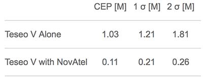
NovAtel has demonstrated high-accuracy positioning performance using automotive-grade GNSS chipsets Teseo APP and Teseo V from STMicroelectronics. Combining automotive-grade multi-frequency GNSS chipsets with positioning algorithms and correction services from NovAtel improves the achievable positioning accuracy available to automotive users and provides a solution suitable for autonomous operation.
According to the company, these chipsets provide multi-frequency GNSS data for precise point positioning (PPP) and real-time kinematic (RTK) to enable accurate positioning capabilities. Teseo APP features built-in integrity checking for use in safety-critical systems, whereas Teseo V is used for non-safety-critical precise positioning applications.
The collaboration between the two companies is designed to reach car manufacturers and Tier 1 suppliers for future production models.
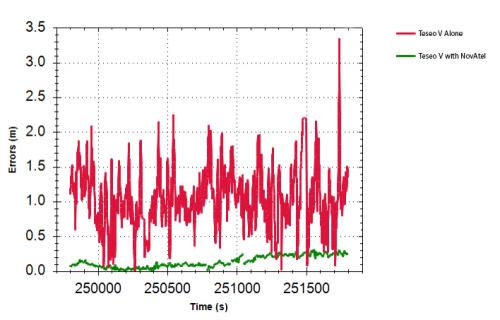
Test results: Horizontal position errors. Teseo V alone is shown in red, Teseo V + NovAtel in green. Test results: Horizontal cumulative error distribution. Teseo V alone is shown in red, Teseo V + NovAtel in green. (Chart: NovAtel)
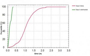
Test results: Horizontal cumulative error distribution. Teseo V alone is shown in red, Teseo V + NovAtel in green. (Chart: NovAtel)
Driven Today. “STMicro is one of many chipset manufacturers coming to market with dual-frequency chipsets targeting the automotive sector,” said Jonathan Auld, VP Engineering and Safety Critical Systems for NovAtel. “We are taking advantage of their expertise in automotive measurement engines for high-volume, cost-effective reliable positioning. NovAtel brings high-precision algorithm expertise and integration with global corrections supplied by Hexagon Correction Services to this initiative.”
NovAtel’s positioning engine combines the GNSS measurements from these chipsets with inertial measurement unit (IMU) data and Hexagon Correction Services to deliver centimeter-level PPP positioning solutions in real time.
“Working closely with STMicroelectronics allowed us to innovate and drastically reduce time to market of our assured positioning solution tailored specifically for safe positioning of autonomous vehicles,” added Auld.
Comparison of GNSS Performance possible in automotive today (red), L1 automotive with corrections (green) and L1/L2 automotive with corrections (blue).
Driverless Tomorrow. “Precise absolute positioning is just one piece of the overall autonomous vehicle puzzle and must be done with safety and integrity concepts in mind.” Auld pointed to the partnership announced in 2016 between NovAtel, the Illinois Institute of Technology, and Stanford University to conduct leading-edge research to determine how GNSS technology can deliver a positioning solution that meets both the safety and accuracy requirements of autonomous automotive vehicles.
Previous research by academia and industry into GNSS integrity produced the successful WAAS program for aviation. The new work underway will extend the scope to include the autonomous ground vehicle use case. The research includes updated and expanded concepts for high-integrity carrier-phase algorithms as well as expanded threat models and safety monitors.
At the Automotive Tech.AD in Berlin, Auld added: “Today the primary use case for positioning in navigation is single-frequency GNSS, with up to 2 constellations, using narrowband RF and antennas, obtaining accuracy at the 1–2 meter level. This is primarily done with pseudorange-based positioning techniques, with some carrier-phase assistance. There are no functional safety standards, and so safety data is provided on the output solution.”
Autonomous Requirements. By contrast, he continued, autonomous operation will require lane-level and better accuracy: 3D centimeter to decimeter absolute positioning. This means multi-frequency, multi-constellation receivers and antennas to improve overall accuracy and increase available measurements. It will also require increased availability through sensor fusion with IMUs and other sensors. All of this must be brought together through a functionally safe development process targeted at ISO26262 Automotive Safety Integrity Level (ASIL) B.
Moving from meter to centimeter level position requires additional processing to handle all the added signals coming in; residual monitoring and observation exclusion, and carrier phase, “the key to centimeter-level positioning,” as opposed to code phase. The vehicle’s localization system must include enhanced positioning algorithms for multipath mitigation, a fast converging corrections network, enhanced Kalman Filters, and sophisticated sensor fusion.
Flexible Integration. NovAtel’s positioning engine architecture enables a flexible integration with different GNSS receiver chipsets, augmentation sensors and processor environments, providing automotive manufacturers with additional flexibility when it comes to sourcing of components and subsystems of advanced driver assistance systems (ADAS) and autonomous driving solutions.
The positioning engine is being developed to ASIL-B standards and will include a proprietary GNSS integrity solution to ensure safe positioning within defined protection limits tailored to the customer’s application requirements.
STMicroelectronics has confirmed the validation of its LSM6DSL 6-axis inertial sensor and LPS22HB pressure sensor for the Alibaba internet of things (IoT) ecosystem, which enables users to create complete IoT nodes and gateway solutions with better time to market.
Launched in 2017, AliOS Things is a light-weight embedded IoT operating system developed by Alibaba. The company recently released AliOS Things v1.2, which includes a sensor-based component called uData.
The ST sensors that have passed the AliOS validation have been integrated in uData, and the two companies are cooperating on the development of IoT systems that aim to improve end-user experiences.
The LSM6DSL is a system-in-package featuring a 3D digital accelerometer and a 3D digital gyroscope that operates at 0.65 mA in high-performance mode and enables always-on low-power features for an optimal motion experience for the consumer.
According to the company, high robustness to mechanical shock makes the LSM6DSL the preferred choice of system designers for the creation and manufacturing of reliable products. The LSM6DSL supports main OS requirements, offering real, virtual and batch sensors with 4 Kbytes for dynamic data batching.
The LPS22HB is an ultra-compact piezo-resistive absolute pressure sensor that functions as a digital output barometer. Dust-free and water-resistant by design, the sensor enables high accuracy and low-power operation. It is available in full-mold package with silicon cap and six 20-µm holes guaranteeing sensor moisture resistance, relative accuracy of pressure measurement 0.1 mbar, and very low power consumption (12 µA in low-noise mode).
“The validation by Alibaba of ST’s LSM6DSL and LPS22HB sensors is an important achievement,” said Collins Wu, marketing director, Analog and MEMS Group, Greater China & South Asia, STMicroelectronics. “Creating and connecting nodes quickly and securely is facilitated by the holistic platform of AliOS, which cuts time to market for users and allows them to create IoT systems in China quickly for applications in smartphones, smart watches, smart locks, smart parking and beyond. On top of this, Alibaba is collaborating closely with ST to integrate more products in the platform, offering compelling IoT solutions for customers.”
NovAtel has integrated its high-precision positioning engine and correction services with automotive-grade multi-frequency GNSS chipsets from STMicroelectronics: specifically, the Teseo APP (Automotive Precise Positioning) and Teseo V.
The integration demonstrates possibilities for vehicle localization solutions. NovAtel is part of Hexagon’s Positioning Intelligence Division.
STMicroelectronics’s Teseo APP and Teseo V provide multi-frequency GNSS data for PPP (precise point positioning) and RTK (real-time kinematic) for accurate positioning capabilities.
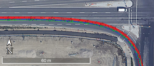
The Teseo V SBAS and Teseo V NovAtel PPP tests took place in a light urban environment. (Image: NovAtel)
NovAtel’s positioning engine combines the GNSS measurements from these chipsets with inertial measurement unit (IMU) data and Hexagon PPP correction services on the demonstration platform to deliver centimeter-level PPP positioning solutions in real time.
“Working closely with STMicroelectronics using their Teseo APP chipset allowed us to innovate and speed up the development of our assured positioning solution tailored specifically for safe positioning of autonomous vehicles,” said Jonathan Auld, VP Engineering and Safety Critical Systems from NovAtel.
NovAtel’s positioning engine architecture enables a flexible integration with different GNSS receiver chipsets, IMUs and processor environments, providing automotive manufacturers with additional flexibility when it comes to selecting components and subsystems of advanced driver assistance systems (ADAS) and autonomous driving solutions.
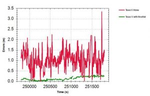
Test results: Horizontal position errors. Teseo V alone is shown in red, Teseo V + NovAtel in green. Test results: Horizontal cumulative error distribution. Teseo V alone is shown in red, Teseo V + NovAtel in green. (Chart: NovAtel)
Test results: Horizontal cumulative error distribution. Teseo V alone is shown in red, Teseo V + NovAtel in green. (Chart: NovAtel)
The positioning engine is being developed to ASIL-B standards according to ISO26262 and will include a proprietary GNSS integrity solution to ensure safe positioning within defined protection limits that are tailored to the customer’s application requirements.
“NovAtel’s choice of the automotive-quality ASIL-capable Teseo APP to integrate with their GNSS positioning engine is enabling them to develop a world-class safety-critical positioning offering to the automotive industry,” said Antonio Radaelli, Director, Infotainment Business Unit, STMicroelectronics.
NovAtel technology continues to be an integral part of the connected and autonomous car ecosystems, including academic research, industry development and real-life applications. The company’s automotive positioning solution includes automotive GNSS antenna technology, GNSS/INS positioning engine, and global correction services.
Assisting safer autonomous driving, STMicroelectronics has introduced a multi-frequency GNSS receiver chipset suitable for safety-critical automotive applications and high-accuracy positioning at the decimeter and centimeter-level for precise point positioning (PPP) and real-time kinematic (RTK) applications.
Traditional in-car navigation systems help drivers reach their destinations using receivers and commercial satellite services that allow positioning accurate to within a few meters.
With increasing use of autonomous systems such as lane-departure warning (LDW), adaptive cruise control (ACC), valet parking and auto-pilot, greater accuracy is needed to ensure safety and reliability, in combination with proximity sensors such as cameras, radar, lidar and others, to monitor the driving environment automatically. Fully self-driving vehicles of the future will also demand high-accuracy positioning.
By tracking satellites of all GNSS constellations simultaneously on at least two of the frequencies used by each system, ST’s automotive-quality Teseo APP (automotive precise positioning) receiver provides high-quality raw GNSS data for PPP and RTK algorithms, which allows accurate positioning and rapid convergence time worldwide.
In addition to its high accuracy, the receiver monitors the integrity of the satellite data to alert the system if accuracy is degraded for any reason. This permits Tier-1 manufacturers to certify safety-critical systems in accordance with the automotive industry functional-safety standard, ISO 26262, up to the highest Automotive Safety Integrity Level (ASIL).
Teseo APP also integrates a secure microcontroller for secure system boot and data-output authentication to keep sensitive data safe from attack.
Launched alongside Teseo APP, ST’s Teseo V chip provides equivalent multi-frequency precise positioning in a simplified device for non-safety-critical applications where integrity assurance is not required.
“High-accuracy satellite positioning makes autonomous driving safer, smoother, and more reliable,” said Antonio Radaelli, director, Infotainment Business Unit, STMicroelectronics. “Our newest Teseo APP GNSS chip combines extreme accuracy and precision with industry-unique integrity assurance for use in safety-critical applications.”
Teseo APP eliminates errors by tracking all available GNSS signals in multiple frequency bands, such as the GPS and GLONASS, Galielo, BeiDou, QZSS, and IRNSS L1, L2, and L5 frequency bands, and the Galileo E6 signal that contains PPP correction data to allow worldwide decimeter-level accuracy.
Other techniques for enhancing accuracy have included differential systems reliant on a combination of ground base-station signals as well as satellite signals, or techniques such as RTK, which generally require a denser reference station network.
The new Teseo chips make high-accuracy affordable for autonomous driving through a combination of tracking up to three constellations simultaneously over two frequency domains. These multi-frequency combinations bring reliable GNSS ionospheric and multipath modeling in most environments, allowing accurate positioning with faster convergence time for automotive applications, where timing is critical.
ST is now supplying product samples to lead customers who are developing autonomous-driving systems expected to appear first in high-end vehicles launched in 2020/2021.
Visitors to Mobile World Congress 2018 in Barcelona, Feb. 26 to March 1, can see Teseo APP at the ST booth, Hall 7, Stand 7A61.
LTE chipmaker Sequans Communications S.A. and semiconductor company STMicroelectronics have introduced CLOE, an LTE-connected tracker platform based on the integration of Sequans and ST technologies.
An acronym of Connecting and Locating Objects Everywhere, CLOE combines the Internet-of-Things (IoT) technologies of two industry manufacturers into one comprehensive platform that simplifies the development of LTE-based IoT tracker devices for the full range of vertical markets, including logistics, consumer electronics and automotive.
Specifically designed and optimized for OEMs and ODMs to add IoT tracking capability to their product offerings, CLOE integrates Sequans’ Monarch LTE Cat M1/NB1 chip and ST’s Teseo III GNSS chip for communications and satellite-based tracking performance.
“CLOE targets multiple vertical markets with best-in-class performance for all of the important tracking measures: battery life, location accuracy, reachability, mobility and reporting periodicity,” said Antonio Radaelli, infotainment BU director at STMicroelectronics. “’Componentizing’ ST’s navigation technology and Sequans’ LTE modem technology makes CLOE an ideal platform to build trackers of all types — anything a developer can think of.”
“The tight integration of ST’s latest-generation Teseo chip with our Monarch LTE chip results in a power-optimized, cost-effective, all-in-one solution to speed new IoT tracker devices to market in a very short time,” said Danny Kedar, vice president of Sequans’ IoT business unit. “CLOE delivers ultra reliable LTE connectivity with ultra-low-power consumption, and high performance GNSS and accelerometer performance, including lowest time to first fix.”
CLOE Key Features
Turnkey cellular tracker solution for OEMs and ODMs, anywhere in the world
Chipset integrates PMU, LTE, GNSS, memories and MCU
First-to-market, operator-certified
LTE Cat M1/NB1 dual-category
Covers all worldwide LTE bands with a single hardware design
High GNSS accuracy and short time to first fix
Support for autonomous or server-based Assisted GPS (AGPS) for optimal time to fix
Designed to address multiple track & trace segments, including
Logistics
Consumer electronics
Automotive
Optimized for low power consumption and cost
Modular design includes GNSS, cellular connectivity, MEMS; can be expanded to include other sensors, Bluetooth and/or Wi-Fi.
CLOE is designed and optimized for production based on a full bill of materials (BOM) that includes LTE, GNSS, accelerometer, power supply, battery management, LED and button management. The modular design enables copy/paste and optimizes BOM cost. CLOE is easily customizable.
STMicroelectronics and Israel-based Autotalks have announced their fusion of GNSS technology and V2X ranging.
The new V2X-Enhanced GNSS ensures authenticated and secure vehicle localization for extreme accuracy and reliability of positioning information, especially in urban canyons, tunnels and parking structures, where accurate absolute and relative positioning-to other vehicles and infrastructure-is critical in progress toward semi- and fully-autonomous vehicles.
STMicroelectronics is a semiconductor company, and Israel-based Autotalks is a V2X-chipset market company involved in the first wave of V2X deployments.
Development of V2X-Enhanced GNSS builds on the companies’ successes in co-developing a V2X chipset that connects vehicles to other vehicles and infrastructure within wireless range for safety and mobility applications, the companies said in a press release.
The promise of efficient, coordinated, and safe driving of autonomous cars can result only from the accurate positioning that the fusion of GNSS with V2X technology achieves, the companies said.
“Autotalks fully recognizes that autonomous driving requires equal measures of reliability, accuracy, and security and no driver would sacrifice any of these,” said Hagai Zyss, CEO of Autotalks.
“Our solutions have been architected from the beginning to enable automated driving and because we recognize positioning for autonomous vehicles as critical, Autotalks, with ST, continues to optimize accurate V2X positioning-and we believe that our customers understand the value and potential.”
V2X-Enhanced GNSS technology, when coupled with V2X-enabled infrastructure, can uniquely provide absolute positioning to vehicles to assure lane-level accuracy. This precision improves navigation in urban canyons and tunnels and is also being used to develop myriad new applications, such as autonomous on-street and in-garage parking and available-spot identification.
“To fully realize the safety, convenience and other benefits of autonomous driving, we need confidence in the security, reliability and accuracy of the communications between our vehicle and its surroundings to know precisely how close we are to things, whether — and in what direction — they are moving, and what they are telling us — such as when there are roadworks or an accident ahead,” said Antonio Radaelli, director of Infotainment, Automotive Digital Division, STMicroelectronics.
“Building upon our successful collaboration with Autotalks, we are combining ST’s state-of-the-art positioning technology and roadmap for high-precision Automotive GNSS supporting satellite signal authentication with Autotalks’ expertise in advanced signal-processing algorithms for ranging, to smoothly pave the road to secure, accurate, and reliable V2X-Enhanced GNSS.”
Field trials in an Asian country, monitored by a government agency, are being used to test this technology in 2016.