At Caltrans District 7 in Los Angeles, we use the onboard GPS capability of smartphones to navigate in real time to the locations of proposed aerial targets and NGS control stations.
KML files are created in the office using desktop GIS, then downloaded to smartphones for use in the field. We create KML files specifically for use by our surveyors during every aerial mapping project within Los Angeles and Ventura Counties.
The aerial target layer also shows the proposed locations of stereo model limits on the smartphone.
Having the stereo model limits as a data layer becomes a handy piece of information in the event an aerial target needs to be relocated due to unfavorable field conditions. The heads-up capabilities of GPS aboard the smartphones and KML files can also show the easiest path to reach either target location or control stations. The NGS control station layer hyperlinks to the NGS website so the field surveyor always has the recovery note available in an electronic format.
The field surveyors are also given hardcopy maps of the target locations and control stations, but those are now only used as a back-up to the KML files loaded onto the smartphones.
We have found that leveraging the onboard GPS capability of smartphones with GIS-based data layers in the field has increased production. Using smartphones provides the surveyors with information more concisely and clearly, so better decisions can be made while in the field. The project surveyor has the ability to tailor datasets specifically to project needed by the field surveyors.
Once the aerial targets have been placed and the NGS control stations recovered, the field surveyors then position the aerial targets and control stations using carrier phase GNSS.
Juniper Systems is exhibiting its sub-meter GPS solution using Esri ArcPad, Effigis’ EZSurv Post-Processing software, and its ultra-rugged handheld computers — a combination the company says is budget-friendly and easy-to-use — at the Esri User Conference, being held in San Diego July 20–24.
The sub-meter solution involves collecting GIS data using a Juniper Systems rugged handheld running ArcPad data collection software, and then using Effigis’ EZSurv software to post-process the data, resulting in sub-meter GPS accuracy. Users can import and export data, including custom attributes, from their GIS. The data collection process bypasses the need for expensive survey-grade GPS receivers, providing both an affordable and simple solution for professionals who require sub-meter accuracy, Juniper Systems said.
“This solution is a great option for people looking for sub-meter accuracy without the steep price,” said Trevor Brown, Natural Resources market manager at Juniper Systems. “The range of applications that can benefit from this type of solution is very broad, with uses in forestry, agriculture, environmental monitoring, and asset management, to name a few. And not only is it inexpensive, it’s also super simple. You can have sub-meter accuracy with the click of a button.”
Those attending the Esri User Conference can see this affordable sub-meter solution at Juniper Systems’ booth #2212. The data sheet can be downloaded, or visit Juniper Systems’ website to learn more.
The 2015 Blue Marble User Conference (BMUC) will take place in Arlington, Va., on Tuesday, Oct. 6. The annual event provides industry experts, Blue Marble software users, product developers, and applications specialists with a forum for sharing experiences and exchanging ideas on the current and future developments in the Global Mapper and Geographic Calculator platforms.
Blue Marble’s geospatial data manipulation, visualization and conversion solutions are used worldwide by thousands of GIS analysts at software, oil and gas, mining, civil engineering, surveying, and technology companies, as well as governmental and university organizations.
Following the success of last year’s User Conferences in Calgary and Houston, the 2015 conference is being consolidated into a single venue, just across the Potomac River from Washington, D.C. As with previous conferences, this event offers a unique and invaluable opportunity to learn about the latest innovations in Blue Marble’s suite of GIS applications; to hear from industry experts about their experiences working with Blue Marble technology; and to network with representatives from a variety of business sectors and government departments.
Over the years, the BMUC has provided GIS professionals with the opportunity to learn how Blue Marble’s innovative geospatial applications are streamlining GIS operations across many industries and to learn how others are maximizing their investment in the software. One of the most popular segments in the BMUC agenda is case studies that demonstrate the inherent flexibility of the software and its ability to meet the challenges of today’s GIS data processing and management tasks. The 2015 event will continue this trend with industry experts from the U.S. Geological Survey, the U.S. military and prominent engineering and survey firms.
“BMUC is the most important event on our calendar every year,” stated Patrick Cunningham, Blue Marble president. “Not only does it allow us to showcase some of the latest advancements in our applications, but it also provides us with an ideal forum in which to engage with our most dedicated users and to garner their input on the continued development of Blue Marble products.”
Space at BMUC is limited and attendees are asked to pre-register to guarantee a spot at this event.
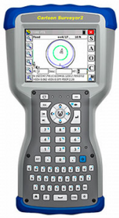
Carlson Software has released the Carlson Surveyor2, the newest model in its Carlson Surveyor line of data collectors. The Surveyor2 is paired with Carlson’s software to provide a powerful, complete solution for surveying, stake out, construction layout, and GIS mapping, the company said.
Designed and manufactured by Juniper Systems, the Carlson Surveyor2 is built to withstand the harshest conditions, with an IP68 rating for dust and water and superb durability when dropped or exposed to cold, heat or other rugged environments.
With minimal increase in weight compared to the original Surveyor, the Surveyor2 offers greater memory and data storage, a faster, 1.0-GHz processor, and significantly improved Bluetooth range — up to 1,500 feet. The data collector also features a new QWERTY keyboard with large buttons for easy data entry, enhanced battery power with 20+ hours of runtime, and a larger, brighter display, providing excellent visibility in any lighting conditions.
The Surveyor2 runs Windows Embedded Handheld 6.5.3 and can be purchased with Carlson SurvCE 4.0, Carlson’s powerful data collection software. SurvCE offers exceptional usability, with a tab-based menu and advanced graphics for easy-to-use functionality, the company said.
“The Surveyor2 and SurvCE together create an advanced solution for surveying applications, while maintaining simplicity and ease-of-use,” said Debbie Trolson, geomatics market manager at Juniper Systems. “The Surveyor2 offers significant improvements over its predecessor, providing surveyors with the features they need to perform their work productively and effectively.”
From our July issue comes this showcase featuring products for surveyors, geographic information systems (GIS) professionals, field workers, and anyone who is looking to expand the capabilities of their smartphone or tablet.
Dedicated Survey/Geospatial
Three-Accuracy Series
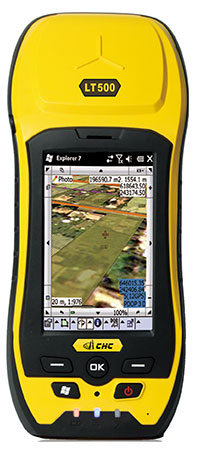
The LT500 series of handheld GPS receivers, LT500H/T/N, covers three accuracy ranges from sub-meter to centimeter. It is a cost-effective full GNSS positioning solution for survey, construction and GIS professionals.
Powered by the Windows Embedded Handheld 6.5 operating system, the LT500 is accurate, rugged and versatile. User productivity is enhanced with the built-in gyroscope, an innovative laser plummet for positioning the accurate handheld receiver over a point, an E-compass for showing the direction and G-sensors for leveling. The LT500 series comes bundled with software including SurvCE, DigiTerra and MapCloud. The LT500H has120 channels (GPS L1/L2/L2C, GLONASS G1, G2, BeiDou B1 and Galileo E1), the LT500T has 220 channels (L1, G1, B1), and the LT500N has 12 channels (L1).
The all-in-one TRIUMPH-LS by JAVAD GNSS combines a high-performance 864-channel GNSS receiver, all-frequency GNSS antenna, and a modern featured handheld. The 864 all-in-view channels include Galileo E1/E5A/E5B, GPS L1/L2/L5, GLONASS L1/L2/L3, QZSS L1/L2/L5, BeiDou B1/B2 and SBAS L1/L5.
More than 100 channels are dedicated to continuous interference monitoring, allowing safe GNSS operation in a city, airport and military environment.
The GEOmeter MX system is designed to gather GIS information in heavily wooded areas, with object description, area coordinates and measurement time grasped automatically. The system consists of the GEOsat MXbox receiver, a combination antenna, a PDA such as the Trimble Recon or the Handheld Nautiz X8, and GEOfield software for mobile GIS.
The Mxbox receiver is a Hemisphere multi-constellation GNSS OEM board with GPS, GLONASS, BeiDou, Galileo and QZSS, plus code- and carrier-phase tracking for increased positioning accuracy and availability. The GEOfield software offers reliabe recording, representation and processing of geodata. Measurement quality is indicated in the field with statistics and graphics, in either German or English.
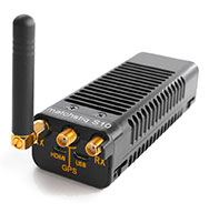
The Matchstiq S10 is a software-defined radio (SDR) platform. It provides increased RF flexibility, RF performance and signal processing capacity in a small package. The Matchstiq S10 platform combines the Epiq Solutions’ Sidekiq SDR with a quad-core processor system running Linux. The Sidekiq MiniPCIe SDR card provides an independently tunable RF transmitter and receiver covering 70 Mhz to 6 Ghz with an RF bandwidth up to 50 Mhz, plus FPGA. The Matchstiq S10 platform also integrates GPS, Gigabit ethernet (with PoE), USB 2.0 OTG, HDMI and real-time clock in a very small form factor package.
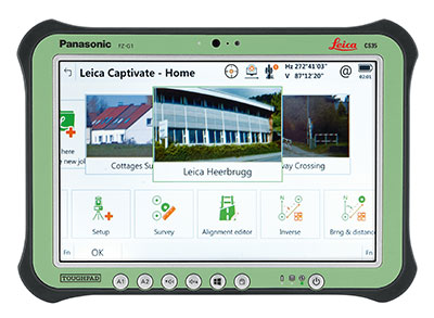
Leica Captivate software provides a 3D view for the Leica Viva GNSS, merging the overlay of measured points, 3D models and point clouds into a single view.
Using Leica Captivate, users can capture and manage complex data with the touchscreen on both the Leica CS20 handheld controller and the CS35 tablet.
The CS20 runs on Windows EC7 and is IP68 and MIL-STD-810F rated. It has a 5-inch WVGA color touchscreen that allows for comfortable and quick data processing and a fully integrated radio and antenna for long range robotic total station control. The CS35’s 10.1-inch screen is visible in all conditions. It runs on Windows 8.1 Pro, enabling workers to take their office into the field. It is IP65 and MIL-STD-810G rated.
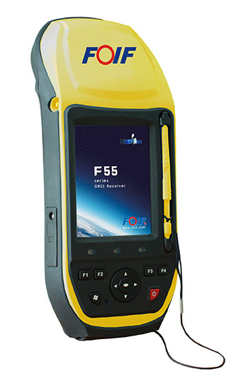
The FOIF F55 series GIS handheld comes in two models: F55-A and F55-B. The onboard software FOIF SuperGiS allows users to conduct field mapping with powerful functions for data collecting, data editing and data querying.
The F55 measures 234 x 99 x 56 mm and weighs 895 grams. It has an IP65 rating for water and dust protection. The F55-A supports four GNSS (GPS, GLONASS, Galileo and Beidou) as well as SBAS, and can search for up to 120 channels. The F55-B supports GPS and SBAS and provides 12 channels.
With Differential GPS, the F55-A has an accuracy of 0.4 meters, and the F55-B has an accuracy of 0.5 meters. RTK surveying on the F55-A obtains high precision of 1 cm + 1 ppm. Real-time correction service and post-processing are available.
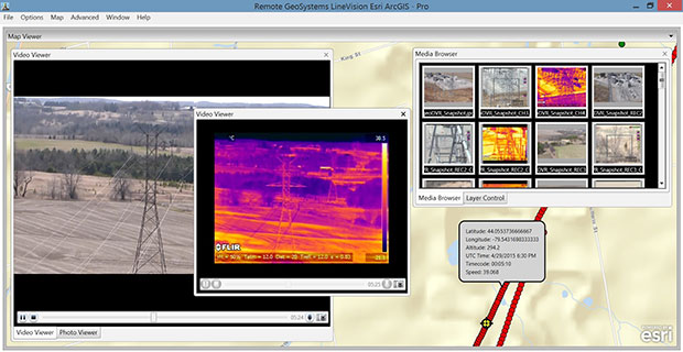
The geoDVR Gen2 is an advanced multi-channel high-definition/standard-definition geospatial digital video recorder designed for aerial and mobile environments.
Unlike a DVR, the rugged geoDVR permanently embeds videos with important GPS location, time and other data — the GPS metadata remains intact even when a video is edited. Most video cameras and gyro-stabilized gimbals can be connected to the geoDVR for recording of HD or geospatial video files.
Video files created by the geoDVR can be analyzed in the RemoteGeo LineVision suite of mapping applications, including tools for Google Earth, Esri ArcGIS, PLS-CADD and the LineVision Cloud. The administrative dashboard allows for monitoring up to four video streams in real-time.
The G1-m1 receiver is part of the G1 family of products from Geomatics USA. The G1 system is scalable from a single-frequency semi-mobile receiver — for control networks and some semi-kinematic mapping applications — to a dual-frequency network RTK solution. It was designed to be lightweight, accurate and portable, especially suited to building a system for travel; for example, all the G1-m1 components, including tripod, will easily pack into a baseball-style bag for transport. The G1-m1 offers centimeter and sub-foot accuracy (centimeter-level accuracy is possible for OPUS-compliant static sessions).
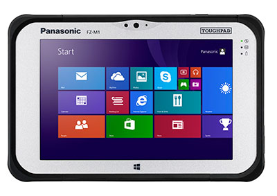
The Panasonic Toughpad FZ-M1 is a thin, light and rugged 7-inch Windows tablet with dedicated GPS — the u-blox Neo M8 series — as an option. The FZ-M1 is built to enable mission-critical mobile worker productivity. Powered by Windows 8.1 Pro and a choice of two Intel processors, it features a long life, user-replaceable battery and a daylight-readable, high-sensitivity multi touchscreen for use with heavy gloves. With a broad range of configuration options, the customizable Toughpad FZ-M1 is rated MIL-STD-810G and IP65, resistant to five-foot drops, weather, dust and water.
Trimble’s RTX technology-based correction services — Trimble CenterPoint RTX, Trimble RangePoint RTX and the new Trimble ViewPoint RTX — are now available on Trimble Geo 7X handhelds.
Trimble RTX technology provides compatible GNSS receivers with correction services that significantly improve accuracy and reliability in obtaining positions worldwide. Operational efficiency and productivity in the field is improved by delivering real-time DGNSS corrections directly to the Trimble Geo 7X handheld.
The handheld solution is designed for industries such as utility companies, municipalities and environmental management agencies, in which workers are highly mobile and require a reliable, flexible data-collection and asset management solution.
A choice of RTX correction services ranging from 4 centimeters to submeter-level horizontal accuracies is available.
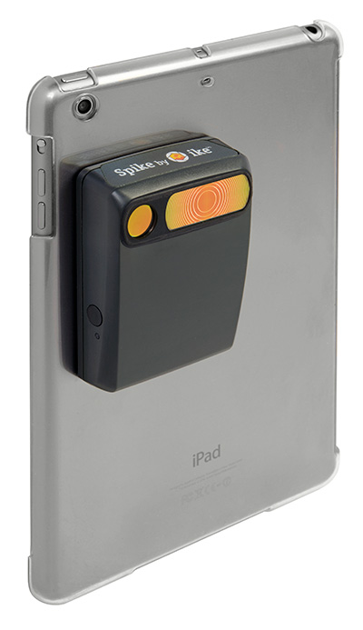
The Spike device and Spike mobile app allow users to measure an object by capturing a photo from a smartphone or tablet. From the photo, users can capture real-time measurements, including height, width, area, length and target location. Location data includes latitude, longitude and altitude. Spike is useful for construction, inspection, safety, advertising, real estate, insurance and government applications.
Measurements and location data are saved with the picture and can be shared via email as a PDF, XML and KMZ. KMZ files can be imported into GIS tools such as ArcGIS and Google Earth. The photo can be referenced via the Spike app to take new measurements or view original measurements.
The Spike device pairs with an Android or Apple iOS smartphone or tablet via Bluetooth. Its laser rangefinder works with a smartphone’s camera, GPS, compass and Internet connection.
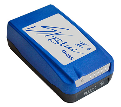
The iSXBlue II+ GNSS is a palm-sized receiver that delivers real-time, high-accuracy performance using GPS+GLONASS satellites and free SBAS corrections for an iPad or iPhone. Its battery-powered lightweight design is for a variety of mapping applications including GIS, forestry, mining, utilities, agriculture, surveying and environmental. It delivers high accuracy in real time without the need for post-processing or another correction source when SBAS (WAAS, EGNOS, MSAS or GAGAN) are available. Using both GPS and GLONASS satellites, the iSXBlue II+ GNSS will work where GPS receivers struggle, such as in the forest, around buildings and in other difficult mapping environments. The L1/G1, GPS+GLONASS receiver has 372 channels.
TerraGo Edge allows organizations to collect data and share field information on their smartphones and tablets. TerraGo Edge replaces traditional GPS handheld devices with a mobile cloud-based solution. Users can collect GPS data points at any accuracy level, either by using the onboard GPS on a smartphone or by attaching a centimeter-level GPS receiver to a mobile device.
TerraGo Edge 3.6 features enhanced support for high-accuracy GPS receivers such as EOS and SXBlue on both iOS and Android, as well as better mapping features, basemap sources and integration with Google Earth.
For managers, TerraGo Edge provides a real-time dashboard for monitoring field users and data collection.
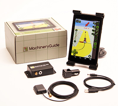
MachineryGuide enables a tablet or smartphone to be used as a precision tractor GPS system. The MachineryGuide Android guidance program functions as a precision farming application using an antenna capable of receiving and processing EGNOS and WAAS corrections. It can be used for any farming activity that is done by tractor or other agricultural machinery, including fertilization, manure application and spraying. It even can be used for land measurements.
MachineryGuide sells the software separately; a GNSS receiver + antenna separately; and a package bundle that includes software, GNSS receiver and antenna. The receiver uses GPS, GLONASS, SBAS and QZSS signals for a position accuracy of 2.5 meters CEP.
The TomTom Bandit Action Camera allows creation of videos within moments of the action. It comes with a built-in media server, eliminating the need to download footage before editing. The camera works with a companion app, making it possible to create and share videos in a matter of minutes — by shaking a smartphone.
The TomTom Bandit Action Camera is equipped with in-camera motion and GPS sensors to automatically find and tag footage based on speed, altitude, G-force, acceleration and heart rate. Highlights can also be tagged manually with a tagging button on the camera or the remote control.
The Forerunner 225 integrates optical heart-rate technology by Mio and features a colorful graphic interface showing runners their zone and beats per minute at a glance. A built-in accelerometer provides distance and pace data for indoor running with no need for a separate foot pod. To keep runners active between workouts, it doubles as an activity tracker, counting steps, calories and distance.
When paired with a compatible smartphone, the Forerunner 225 will automatically upload a completed run to the Garmin Connect Mobile app for post-run analysis and sharing on social media sites. Runners can also use live tracking to allow friends and family to follow along during training or on race day to see stats in real time.
Spectra Precision has introduced its new SP60 GNSS receiver. Designed to meet the evolving needs of surveyors, the SP60 is a versatile solution combining next generation Spectra Precision GNSS technology, a high level of configuration flexibility and an innovative design, the company said. The SP60 is part of Spectra Precision’s latest portfolio of GNSS receivers specifically designed for the mainstream survey and construction applications such as cadastral, topographic, control, stakeout and network RTK.
Spectra Precision SP60 features exclusive Z-Blade GNSS-centric technology running on a new-generation, 240-channel 6G chipset. The SP60 is capable of fully utilizing all 6 available GNSS systems (GPS, GLONASS, BeiDou, Galileo, QZSS and SBAS), but can also be configured to use only selected constellations in an RTK solution (GPS-only, GLONASS-only or BeiDou-only). With L-Band capability to enable CenterPoint RTX correction service, the SP60 GNSS receiver can deliver centimeter-level accuracy without terrestrial/cellular network availability. The receiver is optimized to provide high accuracy positioning performance worldwide.
With its configuration flexibility, the SP60 is scalable and can be used in multiple configurations and operating modes from a simple post-processing solution to a network RTK or CenterPoint RTX capable rover. In addition, the optional transmit radio or embedded Long Range Bluetooth enables the SP60 receiver to be used as a base and rover system. This extended scalability allows surveyors to begin with a simple solution, and through hardware and firmware upgrades, adapt the SP60 to more complex survey jobs.
The Spectra Precision SP60 is rugged and waterproof, yet compact, lightweight and ergonomic for ease of use in the field. The received also includes a patented inside-the-rod mounted UHF antenna. When the UHF transmit radio module is used, its UHF antenna remains protected inside the rugged rod, extending the radio range performance.
“The Spectra Precision SP60 introduces a new level of configuration flexibility to the surveying market,” said Olivier Casabianca, business area director of Trimble’s Spectra Precision Division. “The SP60 was designed as an extremely versatile receiver, allowing surveyors to make it suitable for a specific surveying project, and then upgrade it to a more complex solution, when needed.”
A little more than a year ago, I became a part of a team of surveyors from across the country to offer testing and input on new technology and programing coming out of JAVAD GNSS. It has been a great honor to work along with Dr. Javad Ashjaee, the other surveyors and Javad’s staff at JAVAD GNSS. Why Javad chose me, I doubt that I will ever know. While I am proud to be a part of what Javad has dubbed “J-Team,” I have realized very quickly how little I know about GNSS. In this series of articles that I plan on putting together, I will chronicle my advances in GNSS and testing of JAVAD GNSS equipment.
As part of my testing, I have been using a JAVAD Triumph 2 base (with 4-watt external radio) and a TRIUMPH-LS rover. I had seen advertisements for this system for many months prior to becoming a member of the J-team. I was apprehensive at first with the difference in the appearance and learning the new software. However, it did not take long to realize how advanced this system, namely the TRIUMPH-LS, was.
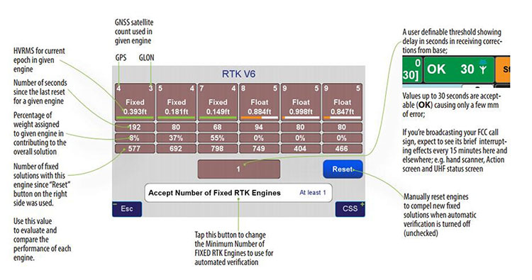
One key feature that I use to determine the quality of my shots is the V6 engines. The V6 engines that it uses to fix the ambiguities is unlike anything I have seen in any other software or receiver. The V6 engines are six separate RTK engines running simultaneously. Basically, this is like having six separate receivers in one.
When in heavy multipath area, I tend to stay fixated on this screen. Each engine can fix at different times. When another engine gets fixed, the resulting epochs are averaged between the two fixed engines and so on with any of the other engines. (See above image.)
This is only one of many technological advancements that Javad has included in his newest receivers. Please continue to follow my articles on other advancements and general surveying practice topics.
For more information on Javad’s J-Field software, the TRIUMPH-LS or other JAVAD GNSS solutions, please feel free to visit www.javad.com, email [email protected], or call 1-888-550-5301 or 1-408-770-1770.
Matthew D. Sibole is a Professional Land Surveyor (PLS) and a member of the JAVAD GNSS J-Team.
When the new Extell luxury high-rise building goes up at 217 West 57th Street in Manhattan, the vertical alignment of the core-wall structure will be crucial to success. This internal core structure will rise almost 1,500 feet above the ground and will be the reference for all other building construction, making its construction one of the most mission-critical aspects of the entire project, according to Leica Geosystems.
Pinnacle Industries, the concrete contractor responsible for building the structure, has invested in an innovative core-wall alignment system. Consisting of advanced GNSS and robotic total station solutions, the Vertical Alignment System from Leica Geosystems will be used as each floor is constructed to ensure the overall vertical geometry of the structure. High-end training from Leica Geosystems will provide the support and knowledge transfer needed to achieve successful adoption of this innovative approach.
The project is noteworthy for a number of reasons. With an overall roof height of 1,479 feet (1,775 feet to top of spire), the new building will dominate the Midtown skyline and will be the tallest residential building in the world. It will also mark the introduction of Nordstrom Inc. to New York City. The architect of record, Adrian Smith + Gordon Gill Architecture, is the firm behind Dubai’s Burj Khalifa, the tallest commerical building in the world.
According to David Rutledge, director of structural monitoring for Leica Geosystems’ Monitoring Solutions business in North America, Pinnacle Industries chose the Leica Geosystems Vertical Alignment System for its ability to reliably and quickly make alignment adjustments to the forming traveler that will be used to construct each floor. The Leica GM10 GNSS instruments in particular were chosen for their ability to produce highly accurate 3D position coordinates.
“It’s very exciting to be involved with the soon-to-be tallest residential building in the world,” Rutledge said. “Pinnacle is an industry leader in this type of construction, and we feel honored to have been selected by the team. Leica Geosystems’ solutions provide exceptionally high accuracy and outstanding performance, making them ideally suited for the high productivity demanded on projects like this. We’re thrilled to be able to play a supporting role in this significant and historic project.”
At 20, 320 feet, Mount McKinley is North America’s highest peak. (Photo courtesy of Todd Paris, UAF).
A new GPS survey of Mount McKinley, the highest point in North America, will update the commonly accepted elevation of McKinley’s peak, 20,320 feet. The last survey was completed in 1953.
The USGS, along with NOAA’s National Geodetic Survey (NGS) and the University of Alaska Fairbanks (UAF), are supporting a GPS survey of the Mount McKinley apex. Surveying technology and processes have improved greatly since the last survey and the ability to establish a much more accurate height now exists, the USGS said.
The Mount McKinley survey team, and their equipment, are expected to face temperatures well below zero, high winds and frequent snow. Current forecast, courtesy of NOAA. (Photo courtesy of Todd Paris, UAF).
An experienced team of four climbers, one from UAF and three from CompassData, will start the precarious trek to the summit with the needed scientific instruments in tow, in the middle of June. They plan to return on or before July 7 and begin work with the University of Alaska Fairbanks and NGS processing the data to arrive at the new summit elevation.
With the acquisition of new elevation (ifsar) data in Alaska as part of the 3D Elevation Program, there have been inquiries about the height of the summit. The survey party is being led by CompassData, a subcontractor for Dewberry on a task awarded under the USGS’ Geospatial Products and Services Contract (GPSC).
Using modern GPS survey equipment and techniques, along with better gravity data to improve the geoid model in Alaska, the partners will be able to report the summit elevation with a much higher level of confidence than has been possible in the past.
According to CompassData, the survey equipment includes two Trimble R10 antennas and one Trimble Net-R9 with a Zephyr-2 antenna. Also being taken up the mountain is a 10-meter specialized glacier avalanche probe and a Ground Penetrating Radar (GPR), courtesy of the University of Alaska Fairbanks.
It is anticipated the newly surveyed elevation will be published by the National Geodetic Survey in late August.
Climbing Mount McKinley, North America’s highest peak, is a daunting task for even the most experienced mountaineers at Denali National Park in Alaska. (Photo courtesy of National Geographic).
Septentrio Satellite Navigation has completed the acquisition and integration of Altus Positioning Systems. Septentrio said the acquisition strengthens the company’s focus on highly accurate and reliable GPS/GNSS positioning equipment, and the integrated company will continue to focus on developing emerging markets across the globe and increase advancements in the field of GIS.
“At the heart of this fusion are our customers,” said Antoon de Proft, CEO and president of Septentrio, “They will benefit from this unique opportunity, which combines the knowledge and experience of Septentrio in GNSS positioning with experience of Altus-PS in survey, mapping and GIS; and from an expanded offering of products and services under one group.”
Septentrio Satellite Navigation and Altus-PS started working together in 2007. The collaboration between the two companies resulted in a series of successful products such as the APS-NR2, APS-3, APS-U and APS-GeoPod, surveying and GIS products that provide essential accurate and reliable results and ease of operation, Septentrio said in a statement. The smart antenna products will form a product line in the Septentrio product portfolio.
The acquisition brings key capabilities and synergies in other areas such as testing, manufacturing and delivery, which will now be based from Septentrio’s corporate headquarters outside the Belgian city of Leuven.
Neil Vancans
Neil Vancans, formerly president of Altus-PS, now becomes vice president of Septentrio Americas. “The fusion of our two companies is a logical step in our evolving business relationship and professional collaboration,” Vancans said. “We look forward to leveraging the strengths of both our organizations to grow the market for Septentrio products across a wide range of market sectors and build the same level of success for Septentrio products in the American market that we have enjoyed elsewhere in the world.”
Septentrio designs, manufactures and sells high-precision multi-frequency, multi-constellation GPS/GNSS equipment used in demanding applications in a variety of industries such as marine, construction, agriculture, survey and mapping, GIS and UAVs. Septentrio receivers are available as OEM boards, housed receivers and smart antennas.
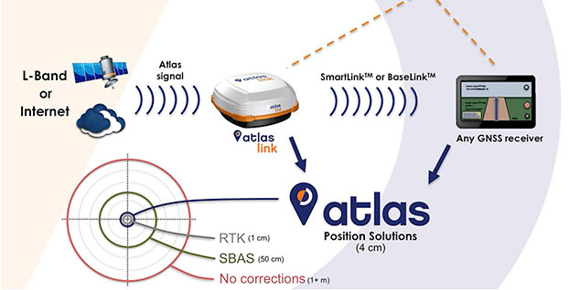
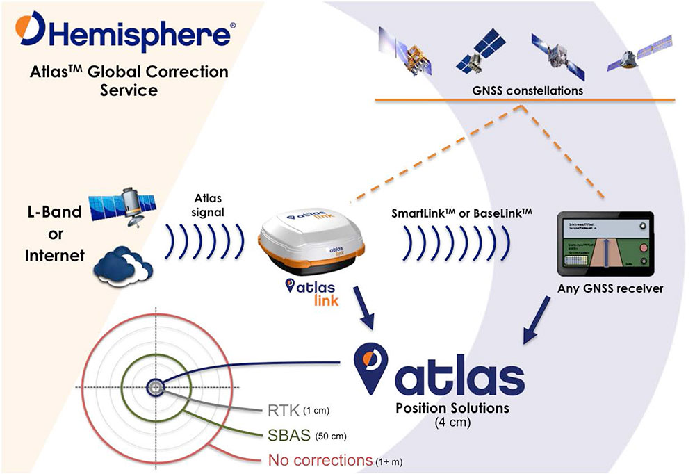
Hemisphere has released Atlas, its new entrant into the GNSS global correction services market. Atlas is delivered via L-Band or the Internet at accuracy levels ranging from meter level to sub-decimeter level. Atlas support is being introduced across a wide range of hardware, including Hemisphere’s new AtlasLink smart antenna, also launched.
“Atlas comes out of a change of culture and focus,” Hemisphere CEO Chuck Joseph told GPS World in an extensive interview that also included Rodrigo Leandro, Hemisphere’s director of engineering, GNSS Positioning Systems. For the full interview, see the second half of this news story.
Starting June 19, Atlas will be available for subscription at the dedicated Atlas web portal across a range of Hemisphere’s multi-frequency, RTK-capable products, such as AtlasLink, R330u, V320 and VS330u. Atlas will also be available from a number of Hemisphere’s channel partners and OEMs such as Carlson Software, Inc.
“Since joining Hemisphere I have heard from customers large and small that they need a different option when it comes to high-accuracy corrections, one they can buy from their provider of choice and with little to no impact on their operating budgets,” said Chuck Joseph, Hemisphere GNSS CEO and president. “We listened hard to what they told us and built Atlas to answer their needs — a totally new service that delivers freedom of choice to our customers along with industry leading corrections at dramatically reduced prices.”
“We formed a team of our most experienced GNSS professionals with the task of developing a roadmap for the future of correction services business and technology in the world — assessing current needs, and also what users across the globe will be looking for over the next decade or two,” said Rodrigo Leandro, Hemisphere director of engineering. “Atlas not only introduces Hemisphere as a business and technology leader in the correction services industry today, it also provides an essential platform for delivering multiple levels of correction services to a very wide range of users spanning commercial business and consumer application use.”
Systems supporting Atlas utilize the newly released and proven Athena GNSS engine. To be able to utilize Atlas corrections, users of supported systems will simply need to update to Athena firmware and purchase a subscription through the Atlas portal.
To build Atlas, Hemisphere GNSS put together a team of seasoned developers whose collective experience matches the best in the GNSS industry. Together they have developed a GNSS correction service, available via L-Band satellite broadcast, which utilizes the most powerful technologies available to deliver a service that matches or exceeds competitive systems across a range of metrics:
Positioning accuracy: Atlas provides competitive positioning accuracies down to 2 cm RMS in certain applications.
Positioning sustainability: Position quality maintenance in the absence of correction signals, using Hemisphere’s Tracer technology.
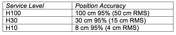
Scalable service levels: Atlas is designed to serve all. It is capable of providing virtually any accuracy, precision and repeatability level in the 5 to 100 cm range.
Convergence time: Convergence times of 10-40 minutes.
Exclusive agnostic capability: Atlas is an agnostic positioning system. SmartLink technology allows an AtlasLink antenna to be used as an Atlas signal extension for any GNSS system compliant with open communication standards.
Network RTK augmentation: BaseLink technology allows Atlas-capable receivers to self calibrate, self-survey, and automatically manage the transmission of RTK correction data to augment or extend established or new GNSS reference networks in areas of poor Internet connectivity.
“High-quality corrections are essential to our customers,” said Randy Noland, director of Machine Control, Carlson Software, Inc. “The way all the existing services are purchased, delivered and supported is completely separated from the rest of the positioning ecosystem. We see Atlas as an opportunity for us to deliver corrections under our own brand as part of a holistic package — all of which means empowering our ability to provide a stronger solution and a better experience for our customers.”
“Atlas completely changes how augmentation services are delivered and supported,” said Andy Smith at Saderet Ltd. “For the first time, distributors and dealers can fully participate in selling to and supporting our customers, strengthening our relationships by providing them with a much better experience.”
“I’ve extensively tested Atlas, and the performance is exceptional, making it a great fit for our GIS and survey customers” said Jean-Yves Lauture at Eos Positioning Systems, Inc. “Even better, we can now offer global augmentation services with our Arrow GNSS receivers to our customers as part of an integrated solution. After many years in this industry, that’s a major change.”
Atlas service levels and position accuracies can be customized to meet OEM needs, the company said.
Exclusive Interview with Hemisphere’s Chuck Joseph and Rodrigo Leandro
A Startup Inside a Reinvention
“Atlas comes out of a change of culture and focus,” Hemisphere CEO Chuck Joseph told GPS World, in an extensive interview that also included Rodrigo Leandro, Hemisphere’s director of engineering, GNSS Positioning Systems. “We are reinventing a storied brand, and to do that we have to act more like the startups I have directed since leaving Trimble — move fast, be flexible, and focus on innovation. Effectively we are building a startup inside of a reinvention.”
“On my first day on the job, we divided the staff into five working groups and told them: you are now startup companies, entrepreneurs, with six people each team. Go away and come back with big ideas. Go build a business plan. Out of that we got Athena, released last month, Atlas, AtlasLink, and a couple more new products coming out in the months to come.”
A Different Kind of Corrections Service
Joseph and his colleagues at Hemisphere describe the distribution, pricing, and overall business model of Atlas as “disruptive.”
“Our approach comes directly from talking to customers in agriculture, machine control, and to our channel partners. Other corrections service providers did not allow them to participate, forced them to give up their end user list, and to buy directly from [the service provider] — who in some cases was their competitor in that market.”
“When you step back you can see the impact of those restrictions — after 10 plus years the corrections service marketplace generates probably $150 million in total revenue — it should be bigger than that by now. We think a different approach combined with a very aggressive price point will substantially broaden the marketplace.”
“We’ll be making announcements of OEM signings in the months to come. For us it’s all about what works for our partners — some of them will private-label the service, some will choose to use the Atlas brand. We really don’t care if our name is on the product or not — we’re an OEM play. Whatever brand they choose, we will provide them with the infrastructure to be successful, even down to the portal their customers will use to manage their devices and subscriptions — we will develop that for them, and provide the back-end e-commerce.”
A Look at the Technology
Rodrigo Leandro added, “The basic architecture is not extremely different from other L-band reference services. However, within that, we have really pushed to develop leading-edge technology. For example, our correction method format is well-developed for new constellations and different applications it can serve, and our corrections message structure is the most advanced of those available today. As a result, we have a number of patents pending on technologies included in Atlas.”
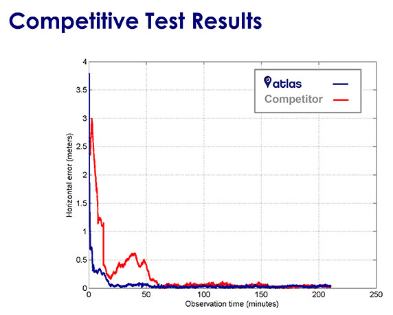
Chuck Joseph interjected, “When we were doing the initial planning for Atlas we agreed that it was absolutely critical that our performance meets or beats the competition’s, otherwise we wouldn’t want to offer it to customers out there. We have been benchmarking the competition at every stage of our development, and know that we are delivering a market leading product.”
“This slide shows the same, single antenna connected to Atlas and to a competitor, and it shows being able to converge down to decimeter level.
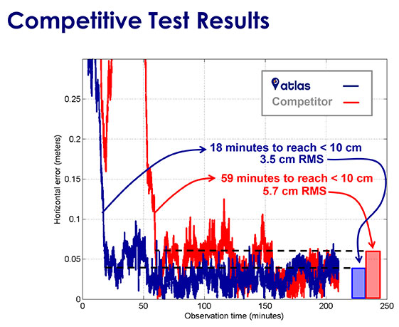
“This one gives more details on time to converge.
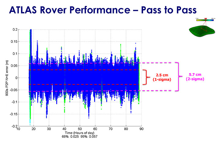
“And here, this one shows pass-to-pass results, the relative accuracy between 2 tracks of the tractor — this is important for people more interested in agriculture applications. We can get down to 2.5 centimeters.”
“The new AtlasLink antenna is designed to be a main channel for customers of our service. It can be used in GIS, machine control, marine applications and so on. Features inside it include a very big internal memory storage, a web server application, multi-GNSS multi-frequency capability, L-band and RTK — it supports Atlas and Athena out of the box. Other innovations will come later, for instance, incorporating Galileo. We believe it is the most powerful multi-purpose GNSS smart antenna in the industry.”
“At the same time there is easy support and easy configuration by the user. It takes literally about six clicks from log-in to register the receiver, out of the box. In 20 minutes you’re running Atlas. It’s very easy to get up and running.”
Broadening the Market
Leandro continued, “The Atlas service isn’t the only area of innovation however. We also spent a lot of time working on how we could deliver the service to the broadest possible audience, and the resulted in two key features of our AtlasLink antenna — SmartLink and BaseLink. Those features free customers from the restrictions of their current hardware and current service — they really change the game.”
“Customers don’t want to have to buy a new $10-$20K receiver [in order to get a corrections service]]. If you’re happy with the hardware you’re currently running, there’s no need to change it, you can still get this service. We are not in the business of using the service to sell hardware. We are using the hardware to sell the service.”
Joseph concluded, “This is all good for OEM customers. For them the SmartLink and BaseLink capabilities are huge. They can go back into their installed base and not have to push people to upgrade receivers or get a brand new receiver. At the same time, it enables them to go after their competitors installed base, and opens up markets that previously weren’t available such as recreational marine service, for example, the lower end of the marketplace. Fundamentally, we want to change this market — enable more users to get access to correction, and deliver real choice to those that have it already.”
Trimble displayed the Multirotor G4 Surveying Robot at the AUVSI Unmanned Systems Show in May.
Trimble is partnering with unmanned aircraft system (UAS) manufacturer Multirotor service-drone, GmbH. The collaboration will allow Trimble to expand its existing UAS portfolio to provide its customers with additional solutions to choose from based on their aerial imaging project needs.
Multirotor service-drone, based in Germany, is a manufacturer of multirotor systems. Trimble will be Multirotor service-drone’s exclusive provider of multirotor vehicles for aerial mapping use in surveying, construction, mining, agriculture, oil and gas, and utilities. The combination of Multirotor service-drone’s stable and reliable platforms with Trimble’s industry-leading sensor technology and workflow efficiencies will provide customers with best-in-class solutions for aerial data capture.
Unmanned multirotor systems are powerful solutions for visually documenting smaller areas, vertical structures or environments where holding position is important. High-resolution imagery, orthophotos, terrain models and normalized difference vegetation index (NDVI) map deliverables created from multirotor data provide valuable information for the survey, engineering and agriculture industries that Trimble serves, the company said.
“We are very excited to partner with Multirotor service-drone. At Trimble we’re always looking for ways to meet our customer’s needs and enable them to solve the complex problems they encounter every day,” said Todd Steiner, product marketing director in Trimble’s Geospatial Division. “The collaboration will enable our customers to use a technology rapidly growing in popularity due to its flexibility and productivity.”
Founded in March 2011, Multirotor service-drone quickly became a market leader in the area of professional unmanned aerial systems. In 2013, service-drone acquired competitor Multirotor and together developed the award-winning fourth-generation flight control system used in its service-drone products today. Multirotor service-drone offers a broad range of commercially used UAS within the 8 to 50 pound (4 to 25 KG) weight class. Designed and manufactured in Germany, Multirotor service-drone products are built to deliver safety, quality and consistency for professional applications, according to the company.