Topcon Positioning Systems has received a national exemption from the Federal Aviation Administration (FAA) that allows for operation of its unmanned aerial system (UAS) in the United States. The exemption covers the operation of the Sirius Basic and Sirius Pro for aerial data collection.
The Sirius Pro and Sirius Basic systems are designed to produce accurate solutions for the automated mapping of a wide range of sites — regardless of terrain — including construction sites, mines and quarries. The UAS are designed for land surveying, transmission line and pipeline inspection, and agricultural operations such as field mapping and livestock management. With the Sirius Pro model, Topcon eliminates the need for ground-control points by combining real-time kinematic (RTK) GNSS solutions with precision timing technology to provide accurate mapping results, Topcon said.
“This exemption is exciting news for the U.S. marketplace,” said Eduardo Falcon, executive vice president and general manager of the Topcon GeoPositioning Solutions Group. “It allows Topcon to be a resource for end-users and provide UAS demonstrations and training. Aerial data collection has a strong impending impact on all the industries we serve, and the possibilities for survey, construction, and agricultural applications are seemingly limitless.
“Building on the success the Sirius models have already seen in the European and Australian markets, this exemption allows Topcon to expand on that momentum in the U.S.,” Falcon said.
Trimble has expanded its portfolio of geospatial solutions for surveyors, engineers and mapping professionals. Highlights include new total stations, a new GNSS receiver and new field and office software features. The solutions save time, reduce costs, streamline workflows and produce high-quality geospatial deliverables across a wide range of industries, Trimble said.
“Trimble’s portfolio expansion will enable our customers to work in a more efficient, seamless and collaborative manner,” said Chris Gibson, vice president of Trimble. “Trimble’s solutions are best known for quality, dependability and performance. Our vision is to equip customers with the most innovative tools, which includes a focus on offering new software applications that streamline and elevate the value of geospatial data to guide smart decision-making and transform the way organizations work.”
The expanded portfolio of productivity solutions include:
Total Station Solutions
A range of new and enhanced robotic total stations — the Trimble S5, S7 and S9 — improve project efficiencies, productivity and deliverables. Times saving enhancements include improved Trimble VISION technology, SureScan technology included in the S7 and optional in the S9 total station, and the DR Plus electronic distance measurement technology as a standard feature.
Theft and loss risks are also minimized now with Locate2Protect technology embedded in each instrument, allowing users to remotely track the location of their equipment in real-time using Trimble InSphere Equipment Manager.
In the office, Trimble Business Center software can be used to create high-dynamic-range (HDR) images using data captured with total stations. A new total station data editor enables fieldwork to be rapidly reviewed and allows surveyors to create deliverables with confidence, Trimble said.
Scanning Solutions
Trimble continues to blend powerful 3D laser scanning and imaging hardware with workflow-based software to drive new efficiencies for survey applications and construction planning and design.
The Trimble TX8 3D laser scanner now offers greater accuracy (down to 1 mm) and streamlined onboard operation when measuring to longer ranges, decreasing the field time required for capturing reliable high-accuracy data.
Enhanced tools in Trimble RealWorks software version 9.1 further reduce the time to produce high-quality deliverables from Trimble TX8 data. The new version of Trimble RealWorks software includes improved workflows for creating floor settlement plans and 3D pipeline models as well as complete storage tank inspection and reporting capabilities.
GNSS Solutions
The new Trimble R8s Integrated GNSS receiver and updated version of Trimble Access field software combine to offer configurable and scalable settings. Surveyors have the flexibility across their workflows by being able to tailor the Trimble R8s receiver with the updated field software for their specific application. The ability to customize provides flexibility for future business requirements and allows customers to maximize efficiencies across their workflows.
Imaging Solutions
Trimble enhancements to Trimble VISION workflows increase the value of highly accurate image data. Survey, engineering and civil infrastructure professionals can now generate dense point cloud deliverables in Trimble Business Center from images captured using the Trimble V10 Imaging Rover. Users can also quickly generate 2D CAD and 3D real-world models from images captured with Trimble total stations using the streamlined workflows created within Trimble Business Center and SketchUp software.
Availability
Trimble Access field software, Trimble Business Center version 3.50 office software, the Trimble R8s GNSS receiver, Trimble S5, S7 and S9 Total Stations and TX8 3D Scanner are available now through Trimble’s Geospatial Distribution Channel.
Topcon Positioning Group has added to its line of reflectorless total stations for the construction and mining market. The GPT-3500LNW total station has a measuring distance of 2,000 meters (6,560 ft.). It is designed to measure further than any non-prism instrument in its class. “Incorporating the Topcon advanced time-of-flight pulse technology, the EDM is fast and powerful,” said Ray Kerwin, director of global surveying products. “The Topcon algorithm filters signal noise to provide accurate measurements even on dark and wet surfaces, where other reflectorless technology might fail.”
The Topcon GPS-3500 total station.
Along with its onboard data collector, the GPT-3500 can connect to an external field controller via built-in Bluetooth technology, enabling field to office connectivity with the MAGNET suite of software solutions. The system can also be paired with a prism to allow for a measurement range of up to 3000 meters (9,842 ft.). Additional features include a rugged IP66 rated design, on-board TopField application software and battery life of up to five working hours.
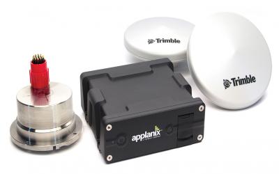
Applanix has introduced an expanded portfolio of marine georeferencing and motion compensation solutions. Taking advantage of Applanix proprietary technology, the new line-up of marine products offers high-performance solutions to a broader cross-section of the hydrographic survey industry.
All Applanix Marine products benefit from the optimal integration of GNSS and inertial observables, with access to Trimble GNSS technology for performance advantages.
The Applanix POS MV Surfmaster.
The announcement was made at Ocean Business 2015, an exhibition of more than 300 of the world’s leading manufacturers and service providers in the industry.
“Advances in Applanix inertial technology enable us to offer the high performance levels we are known for at even more attractive price points. By introducing this new product portfolio, we are able to deliver solutions suited to all types of bathymetric mapping,” said Peter Stewart, director of Marine Products. “This revised product lineup demonstrates Applanix’ continued commitment to provide customers with options that best fit their budget and requirements.”
At the entry level of the expanded product portfolio, Applanix introduced the new POS MV SurfMaster. Incorporating Applanix’s proprietary SmartCal inertial calibration techniques, POS MV SurfMaster delivers robust georeferencing for small platforms, both manned and unmanned. SurfMaster is fully supported by Applanix’ post-processing software POSPac MMS, and can deliver roll and pitch accuracy to 0.03 degrees, regardless of latitude or rate of vessel motion.
Applanix’ new marine product lineup also includes POS MV WaveMaster II and POS MV OceanMaster. Using newly developed inertial technology, POS MV WaveMaster II delivers performance equal to the well-established and proven WaveMaster E, but at a new lower price point. POS MV OceanMaster replaces the POS MV 320 E as the georeferencing and motion compensation solution of choice for the hydrographic professional, integrating next generation inertial sensors, which enable performance and pricing previously unavailable with this class of technology. POS MV OceanMaster provides reliable and robust surveying in even the most demanding sea conditions. POS MV Elite remains the ultimate option for users seeking the highest level of performance available to the industry.
The new POS MV SurfMaster, POS MV WaveMaster II and the POS MV OceanMaster are available now worldwide through the Applanix sales channel.
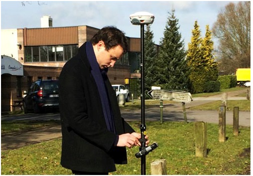
Experiencing the Qiao Station with ComNav T300 for surveying.
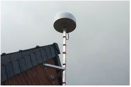
Europe’s first commercial BeiDou CORS station — Qiao CORS Station — has been built in Wallonia, Belgium. ComNav partnered with local company CGEOS – Creative Geosensing on the project. ComNav develops and manufactures GNSS OEM boards and receivers for demanding high-precision positioning applications.
Qiao means bridge in Chinese, and Joël van Cranenbroeck, managing director of CGEOS, is working to build the bridge between the Chinese and European GNSS industries by introducing the Chinese high-precision GNSS technologies of ComNav Technology to European users, ComNav said in a statement.
The Qiao Station can track BeiDou Navigation Satellite System on the three frequencies and transmit observation data in RTCM format in real time through NTRIP and observation data in RINEX format. It enhances the positioning performance and result by combining BeiDou with GPS and GLONASS.
Currently, the BeiDou Navigation Satellite System mainly covers the Asia Pacific region. Though China is still in the process of building it into a global network, up to six BeiDou satellites can now be tracked in Europe during certain periods of the day. With the new Qiao Station, European users can now try the BeiDou system.
Setting up Qiao Station.
European’s first BeiDou CORS station has been built in Belgium.
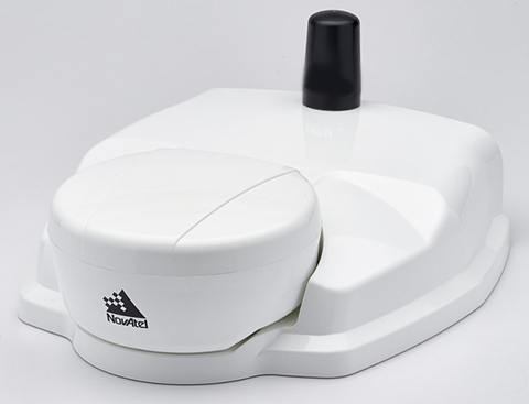
NovAtel’s SMART6-L attaches to the Relay RTK radio module to create a single unit for easy system integration.
NovAtel Inc. has launched the Relay RTK radio module, a docking station that provides radio connectivity for its SMART6-L L-band capable GNSS receiver.
The Relay RTK module combined with NovAtel’s SMART6-L receiver creates a compact, easy to integrate positioning solution, NovAtel said. It is available in four radio versions: 400 MHz UHF licensed band; 900 MHz UHF unlicensed band; HSPA (3G) cellular; and CDMA (1xRTT/EV-DO) cellular. The CDMA version is approved for use on the Verizon cellular network.
The 400 MHz and 900 MHz versions support both base and rover configurations. The base station is configured via the integrated web-server/Wi-Fi access point using the web browser on any compatible personal computer, tablet or smartphone. The cellular radio versions support the reception of NTRIP and RTK corrections over the cellular network.
SMART6-L customers can connect to the Relay using their existing SMART6-L interface cables. Relay has support for both screw and magnetic mounting; optional mounting plates are available for roof and pole mounting. NovAtel’s SMART6-L with Relay provides the same level of performance as a standalone SMART6-L unit with the added convenience of radio connectivity to support RTK and NTRIP corrections.
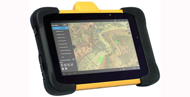
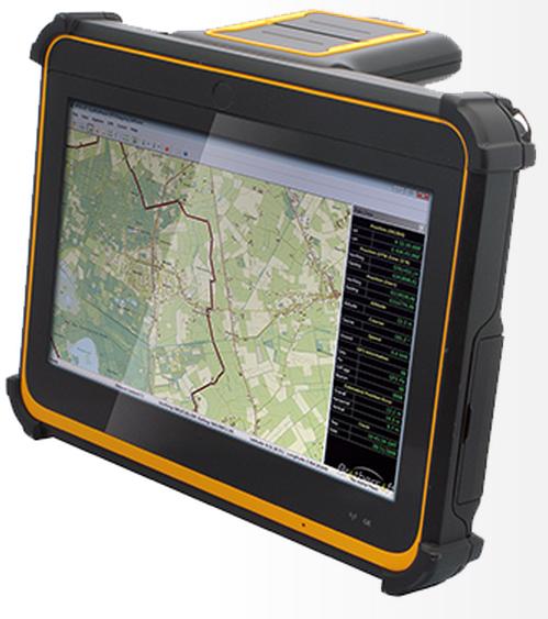
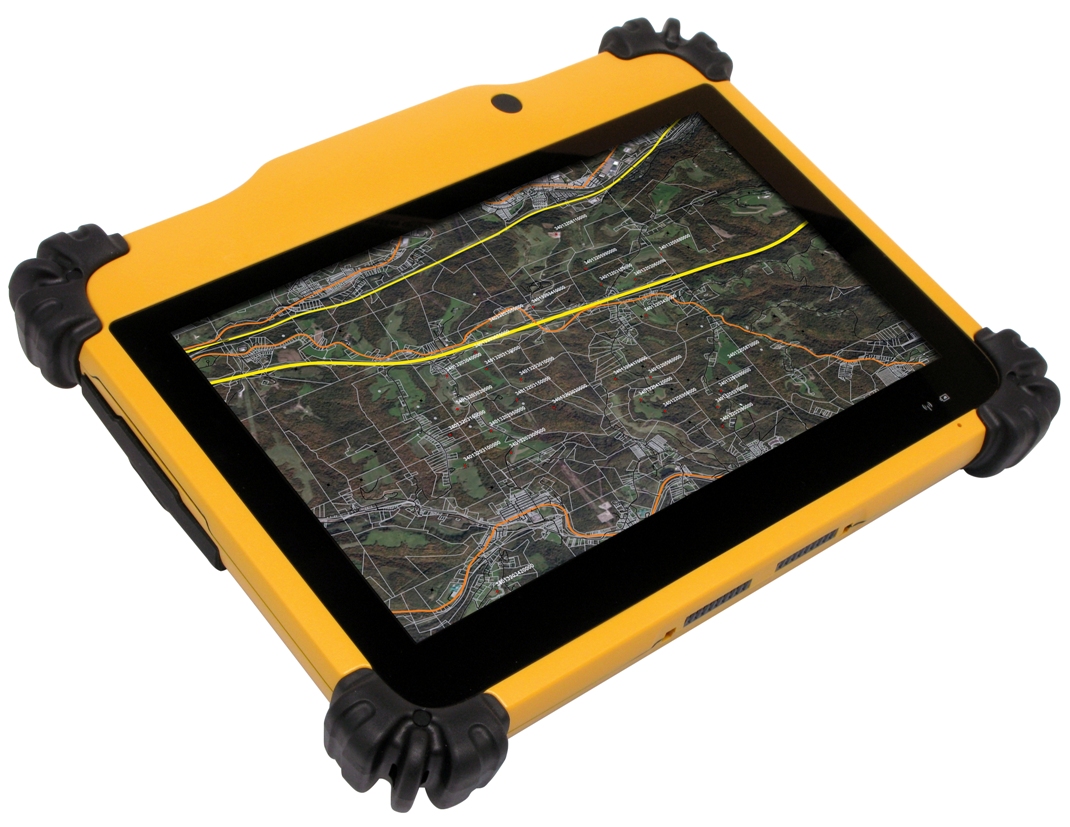
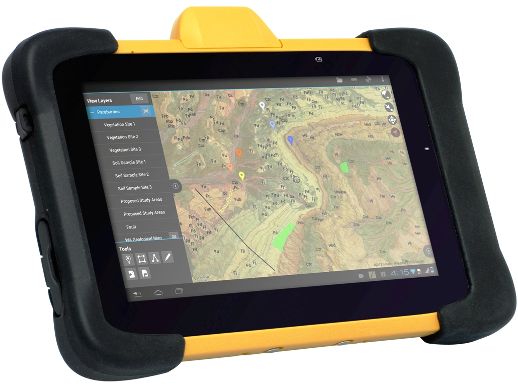
DT Research Inc. has launched a new line of rugged tablets with the GNSS modules for surveying and mapping applications. The DT391GS, DT395GS and DT307GS rugged tablets feature integrated high-accuracy GNSS receiver modules with built-in antenna for seamless data capture, the company said.
Built to travel and provide reliable operations in the real world, the tablets are designed for field work in mapping, geographic information systems (GIS), and accurate synchronization, tracking and networking.
The DT391GS combines a 9-inch sunlight-readable, capacitive touch display with an energy-efficient Intel dual-core processor in a compact, durable package. With the high-accuracy GNSS module options (Hemisphere or Trimble), the foldable antenna, and Windows or Android operating system. The DT391GS also offers protection in demanding environments with IP65 and MIL-STD-810G ratings for dust and water, and shock and vibration resistance.
The DT395GS tablet.
The DT395GS offers a 9-inch sunlight-readable capacitive touch screen, an energy efficient Intel dual-core processor, and a choice of Windows or Android operating systems. The GNSS positioning module has u-blox GNSS module. The IP65 rating, and military-standard MILSTD-810G and MIL-STD-461F ratings, as well as wide temperature range, make the DT395GS reliable even in harsh, mission-critical environments.
The DT307GS GNSS tablet features a brilliant 7-inch capacitive touch screen and a quad-core, energy efficient processor with a built-in, high-accuracy u-blox GNSS module. The size and weight of the DT307GS make this tablet portable for long-term handling in the field, DT Research said.
The DT307GS tablet
All of the DT Research Rugged GS Tablets offer hot-swappable batteries for continuous operation, enabling real-time project efficiency between staff in the field and in the office. With wireless support for Bluetooth, 802.11, WCDMA and HSPA+ connectivity and optional GSM networking, the tablets keep staff connected from any location.
The DT391GS and DT395GS have Trusted Processing Module (TPM) encryption for security support, and a choice of Microsoft Windows Embedded Standard 7 or 7 Professional, or Android operating system making these tablets flexible to integrate with existing applications.
An optional 5-megapixel camera offers another data capture tool to record visual information, and an optional 3G cellular data module provides data connectivity for navigation and real-time data transfer, DT Research said.
The DT391GS, DT395GS, and DT307GS are available now, form more information, contact DT Research at [email protected].
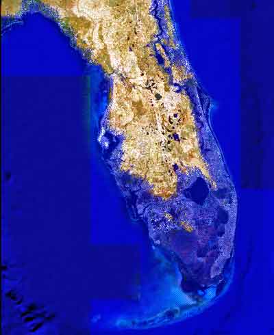
Image showing projected Florida flooding, from flood.firetree.net, using Google Earth with NASA data. Image from flood.firetree.net, using Google Earth.
Surveyors, prepare to get your feet wet. Global warming is about to hit you in the job list. By 2050, a majority of U.S. coastal areas are likely to be threatened by 30 or more days of flooding each year. This according to a December report in Earth’s Future, a journal of the American Geophysical Union.
[Parenthetically, the next issue of Survey Scene, in May, will be written by an actual geodesist. Until then, you have to put up with GPS World’s editor in chief — by no means a surveyor. Patience.]
The study used data from National Oceanic and Atmospheric Administration (NOAA) tide gauges to show the annual rate of coastal floods has accelerated in recent years. These are now five to 10 times more likely today than 50 years ago — and getting worse.
Mitigation decisions could range from retreating further inland to coastal fortification or to a combination of “green” infrastructure using both natural resources such as dunes and wetland, along with “gray” man-made infrastructure such as sea walls and redesigned storm water systems. And that’s not even mentioning such basics as redrawing property lines. Any way you look at it, surveyors are going to be involved.
“As communities across the country become increasingly vulnerable to water inundation and flooding, effective risk management is going to become more heavily reliant on environmental data and analysis,” said Holly Bamford, NOAA acting assistant secretary for conservation and management.
The recent U.S. Hydro 2015 conference in National Harbor, Maryland — an area particularly called out for vulnerability to the oncoming floods — naturally found a lot to talk about in this and related areas of interest for surveyors, with session tracks including: Effects of Climate Change on our Oceans and Waterways; Coastal and Ocean Mapping Initiatives; Advances in Unmanned System Technology, and several more.
Some of the papers presented that GPS World found of interest, and hopes to present or encapsulate in some form in the near future, include:
Resolving Systematic GPS Interference from Aeronautical Distance Measuring Equipment during Mission-Critical Shallow Water Multibeam Surveys
GPS Water-Level Buoy for Hydropgraphic Survey Operations
Examining the Uncertainty Associated with the Establishmenbt of an Ellipsoid to Chart Datum Separation Surface Using GNSS Buoys
Comparison of Horizontal and Vertical Resolvable Resolution between Repetitive Multibeam Surveys Using Different Kinematic GNSS Methods.
And those just came from the poster sessions. In the technical sessions, Jack Riley from the NOAA Coast Survey’s Hydrographic Systems and Technology Program presented a GPS Buoy Water Level Uncertainty Case Study.
Data from on High
Since you can’t get at a coastline from all angles — with any degree of stability, that is — data from overhead, sometimes far overhead, proves invaluable. Such as that provided by aerial digital imagery, LiDAR, and increasingly, satellites.
Because digital aerial images are already in electronic form, they can quickly be processed and made available to users. Most of the special cameras in use nowadays provide direct georeferencing capability, which allows camera position and orientation to be determined automatically using GPS and inertial measurement equipment. An entire mini-industry has grown up around integrating aerial data with that taken from ground surveys.
Light detection and ranging (LiDAR), a remote sensing system, became available for commercial topographic mapping in 1993. An airborne laser scanning system paired with a kinematic GPS receiver and an inertial navigation system can calculate and produce a highly accurate spot elevation. It is possible to obtain point densities that would likely take months to collect using traditional ground survey methods. The National Geodetic Survey (NGS) is currently implementing LiDAR into their shoreline mapping production process.
Our Record So Far
Coverage of these salty issues has been sparse in GPS World and associated newsletters, but not entirely absent. In 2006, the May issue featured “GPS Buoys Nautical Measurement.”
In 2008, Richard Langley edited an Innovation column on “Tsunami Detection by GPS,” featuring work for which co-author Attila Komjathy eventually won a GPS World Leadership Award in 2013. And in 2010, Langley brought forth an Innovation column on “Monitoring Water Level with GNSS.”
And way, way back in 2005, we published “Abreast of the Waves: Open-Sea Sensor to Measure Height and Direction.” This was prior to our digital era, so until we can scan a paper copy into here, we’ll simply give the abstract: “Accurate and timely information on open-sea wave conditions can help in preventing large-scale maritime disasters. This article describes a new, low-cost Global Positioning System (GPS)-based sensor that measures wave height with an accuracy of several centimeters and direction with an accuracy of 5 degrees. The receiver is mounted on a buoy, and a high-pass filter is used to extract the movement of the buoy and thus minimize GPS positioning errors. The data provided by the sensor is intended to improve wave prediction models. In addition, since this GPS-based sensor transmits only analyzed ocean wave data, it reduces the volume of data and leads to lower operating and acquisition costs. The article describes the concept of the GPS-based wave sensor, algorithms that are used for filtering and extracting wave data, as well as the results of open-sea trials.”
So there’s more to come. Watch this space. In the meantime, we leave you with Bob Dylan’s prophetic words, circa 1967.
Well, it’s sugar for sugar And salt for salt If you go down in the flood It’s gonna be your own fault.
Following its debut in 2014, GEO Business returns to The Business Design Centre in London on May 27-28.
GEO Business 2015 combines a central trade exhibition with a conference program with 50 presentations and 140 live commercial workshops.
The presentations and workshops, which provide first-hand demonstrations, have grown in number by 34 percent over the first year. Also larger this year is the exhibit space, by 64 percent, organizers said. The exhibit features more than 200 exhibitors showcasing the latest geospatial technology and services.
The show’s unifying vision is to promote closer collaboration across the geospatial community and to provide a platform that effectively showcases both the professionalism of this industry and the role that it will play in future economic growth. It was born out of consultation with industry and as a result is organized in collaboration with the Chartered Institution of Civil Engineering Surveyors (ICES), the Royal Institution of Chartered Surveyors (RICS), The Survey Association (TSA), the Association for Geographic Information (AGI) and more recently the Institution of Civil Engineers (ICE).
In 2014, more than 1,600 attendees from 39 countries took part. Learn more at the conference website.
Editor’s Note: Alan Cameron is editor-in-chief and publisher of GPS World magazine. He also writes the monthly GNSS Design & Test newsletter. The views expressed are his own.
“It’s tough to make predictions, especially about the future.” This insight comes from the 20th-century American sage Yogi Berra. Yet predictions — hedged guesses, if you will — form the basis of nearly all new business ventures and decisions in ongoing business activities.
For surveyors in the year 2015, one of the key predictions — or guesses — to make concerns the next GNSS to come predictably and reliably online, to augment GPS where GPS alone does not fully function: under canopy, in dense urban environments, and so on. More satellites visible at more varied angles in the sky can help surmount these obstructions.
Staking the future of one’s business, in the form of new equipment acquisition, in such an environment is a bit like betting on a long-distance horse race. First one steed surges to the head of the pack, then it falls back as another charges forward. We have seen this pattern repeatedly in the growth of GLONASS, Galileo and BeiDou.
Some may say that GLONASS, the Russian system, has already won the race (the first heat, at least) and currently fills the role of GPS partner in precision surveying. It does, to some extent, but its future viability is cloudy — and its past record is patchy, to say the least. It rose to full operational capability around the turn of the century, then fell very, very low in numbers as short-lived satellites expired and were not replaced at sufficient rate. Recently, GLONASS has mounted a resurgence, but that has been marred by repeated launch failures and a disturbing anomaly. It cannot be counted or confirmed a winner, yet.
I spoke yesterday with an expert and veteran professional land surveyor who expressed the opinion that the manner in which surveying is conducted will change more in the next five years than it has in the last 25. Keep in mind that the last 25 years saw enormous changes themselves, as GPS significantly transformed, upgraded and made vastly more efficient most surveying activities.
Betting on a horse race in such a rapidly changing environment becomes even more chancy.
Here’s a tip from a racetrack tout: don’t count Galileo out.
GLONASS we recounted briefly above. BeiDou recently achieved a regional operations status over Eastern Asia, but further developments there have been puzzlingly quiet for some time.
The European system has come on with agonizing slowness since the year 2000, suffering many delays and most recently what could have been a debilitating failed dual launch. But the combined strength of the European Union continues to push determinedly forward, and the program has an ambitious schedule with an eye firmly fixed on operability. And some recent research results tend — perhaps — to substantiate the claim, long pooh-poohed by those in the United States, at least, that Galileo will eventually prove “better” than GPS. Details further on.
What might a prudent yet pragmatic, forward-looking surveying firm do in this uncertain environment, where the only certainty is change, and likely to be rapid change at that? Here’s another racetrack tip: don’t make any big bets just yet, but study the field closely and continuously. In particular, watch Galileo’s performance.
A further item to be checked in Galileo’s favor: its system operators have long been in close talks with the U.S. government on many matters involving co-operation and interoperability. As recounted in a recent story concerning the Federal Communications Commission’s surprising role in this matter, the Europeans are filling out the proper forms for full accreditation within the United States. This could turn out to be important in business operations.
Back to studying the field closely: also study leading manufacturers’ offerings in this regard. They also are making bets on the future; quite possibly they have better information, and/or have done more extensive analysis of what information is available, paired with in-depth, highly technical research and development of signal characteristics and how signals from disparate GNSS can be most productively combined.
A quick scan of GPS World’s2015 GNSS Receiver Survey shows the following key manufacturers (among others) have GPS receivers now commercially available that are Galileo-ready: Altus Positioning Systems, Ashtech, Geneq, iFEN, JAVAD GNSS, Leica Geosystems, NovAtel, NVS Technologies, Septentrio, Sprecta Precision, Spectrum, Topcon, and Trimble.
Better than GPS???
Supporters of Galileo have long raised hackles west of the Atlantic with claims that Galileo would provide better accuracy than GPS. Not! cried the faithful, and especially not when the modernized and improved, strengthened, more accurate GPS III signals are coming along just as fast if not faster than Galileo. Recently the pace of GPS III has come into question; can the Gold Standard and clear leader for 25+ years really be falling back into the pack?
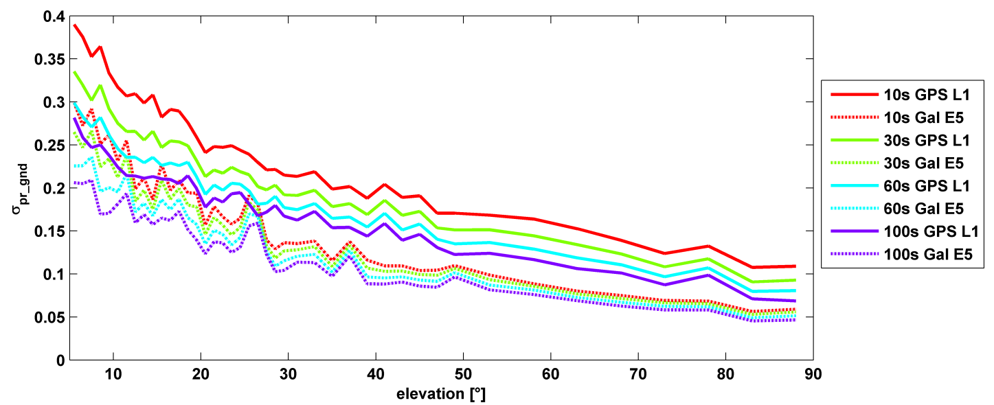
σ(pr_gnd) versus elevation for Galileo E1 (dotted lines) and GPS L1 (solid lines for different smoothing constants: red (10s), green (30s), cyan (60s), purple (100s).
Let’s disregard that question for the time being, and look at some recent research, to be reported in full in the cover story of GPS World magazine’s April issue, out soon. In it, the authors (two German and one American researcher) report:
“Analysis of new Galileo signals at an experimental ground-based augmentation system (GBAS) compares noise and multipath in their performance to GPS L1 and L5. Raw noise and multipath level of the Galileo signals is shown to be smaller than those of GPS. Even after smoothing, Galileo signals perform somewhat better than GPS and are less sensitive to the smoothing time constant.”
This is all pretty arcane and a bit removed from current field of operations, as far as surveyors are concerned. But it does signal something, and it provides food for thought.
The researchers obtained their results using four JAVAD Delta receivers, all connected to Leica AR 25 choke ring antennas.
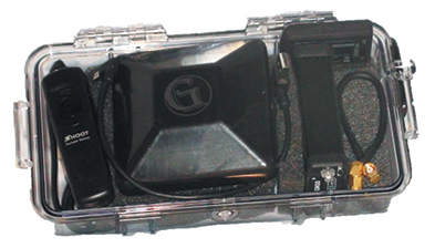
Geomatics USA from Gainesville, Fla., has designed a precision surveying and mapping system that can be easily stowed in an overhead compartment for airline travel. Surveyors can fit everything needed for important mapping and surveying jobs into a baseball-style bag, including tripods. The compact, light-weight system offers differential sub-foot accuracy.
Components easily pack into a baseball-style case.
The G1-m1 receiver system has many advantages over conventional GNSS receivers, Geomatics said. The system is designed for precision surveying jobs that require travel to remote areas of the world, and for traveling to job sites by commercial airline. The complete base and rover kit, including the tripods, rods, and batteries, fits into a single baseball style bag and weigh less than 10 kg, making it easy to stow as carry-on luggage.
The Geomatics USA G1 system is scalable from a simple single-frequency semi-mobile receiver — ideal for control networks and some semi-kinematic mapping applications — to a dual-frequency network RTK solution. All of the Geomatics USA G1 solutions perform precision-quality tasks at a fraction of the cost of major-brand equipment.
The G1-m1 system comes with a free processing software license for the first 50 systems that supports carrier-phase relative positioning and CA-code differential correction. The software is designed with a simple user interface for easy selection of base and rover data or automatic data download of the closest Continuously Operating Reference Station (CORS) from the U.S. National Geodetic Survey database. It is compatible with other RINEX based post-process systems around the world.
Complete survey set including GNSS receiver, antenna, battery and cables, fits in a small handheld plastic case.
According to Geomatics USA Chief Technology Officer Ahmed Mohamed, “The G1 product line fills the gap between survey applications, where cm-level precision is an absolute necessity, and mapping applications, where meter-level precision is acceptable. In fact, the G1-m1 product offers sub-foot precision in most cases and cm-level precision in ideal situations. Geomatics USA uses readily available components and open-source code to develop its end user product solutions. The objective is to make sure the software performs correctly with a very short learning curve for the user.”
For a limited time, Geomatics is offering a specially priced configuration for the first 50 systems through NavtechGPS, its worldwide distributor.