Tag: surveying

  • CHC Offers GNSS Post-Processing Software

    CHC Offers GNSS Post-Processing Software

    CGO Software-CHC

    CHC announced today the availability of CHC Geomatics Office (CGO), a software solution dedicated to post processing static and kinematic GNSS raw data. CGO supports GPS+GLONASS+BeiDou data in various raw data formats and is compatible with major brands, allowing a seamless integration with an existing pool of equipment, the company said.

    “CGO is undoubtedly the most affordable yet powerful GNSS post processing software available in the market.” says George Zhao, CEO of CHC. “In addition, this new product launch reinforces our commitment to provide full GNSS solutions to our customers including post-processing applications.”

    A 90-day fully functional demonstration license is available to enable users to evaluate the CGO’s features before purchasing.

    CHC designs, manufactures and markets a wide range of professional GPS/GNSS solutions in more than 50 countries. Headquartered in Shanghai (China), CHC is a GPS/GNSS manufacturer with a strong international presence and employs more than 500 professionals worldwide.

  • CHC Delivers 520 GNSS Receivers in Big Myanmar Contract

    CHC Delivers 520 GNSS Receivers in Big Myanmar Contract

    The X91+ GNSS receiver by CHC Navigation.
    The X91+ GNSS receiver by CHC Navigation.

    CHC Navigation announced today the successful delivery of 520 units of X91+ GNSS receivers to the Settlement and Land Records Department (SLRD), a part of the Myanmar Ministry of Agriculture and Irrigation.

    Awarded as one of the world’s largest GNSS tenders, CHC Navigation successfully delivered 520 units of X91+ receivers within the tight 60-day time frame allowed by the tender.

    “This might be the largest single contract award for RTK receivers I’ve ever heard of,” commented Eric Gakstatter, GPS World’s survey editor.

    The Settlement and Land Records Department activities encompass the collection of agricultural statistics, annual assessment of land revenue, land lease and tenure, and many other agricultural land administration tasks.

    CHC Navigation, in cooperation with its distributor, IGS Company Limited, demonstrated the performance of the X91+ during stringent field technical assessments versus other major GNSS industry players.

    CHC Navigation demonstrates the X91+ during field technical assessments.
    CHC Navigation demonstrates the X91+ during field technical assessments.

    “We are excited about the international recognition of CHC’s GNSS solution by leading governmental organizations. I believe the win highlights our firm commitment to provide high precision, outstanding quality products and more over dedicated support and services,” said George Zhao, CEO of CHC. “The award of this significant tender is a real achievement in CHC international development.”

    The X91+ GNSS receiver is a compact 220-channel GNSS receiver designed for high accuracy and productivity in harsh environments. According to CHC, the receiver has an easy-to-use, efficient and intuitive work flow, and is optimized for efficient RTK positioning.

  • Trimble Updates Cloud-Based Software, App for Wastewater Management

    Trimble has introduced a new version of its smart water and wastewater management software — Trimble Connect version 1.5. The latest release of the cloud-based software includes a suite of applications that help water and wastewater utilities to deploy smart meters, repair leaks and reduce non-revenue water (NRW), locate and map critical infrastructure using geographic information system (GIS) technology, extend the life of aging assets, and improve worker safety and productivity.

    Trimble Connect software version 1.5 can be configured and deployed quickly on a variety of rugged mobile devices, laptops, tablets and smartphones to automate field workflows and eliminate paper-based maps and field work tracking and management, the company said.

    Over the last decade, water and wastewater utilities have made investments in GIS mapping systems and asset maintenance management databases to manage their pipes and assets that are installed over large geographic areas. A large number of these utilities have implemented the Esri ArcGIS as their primary GIS mapping system. Maintenance of the information is an ongoing task and requires that information about the location of assets and the work performed on these facilities is accurately collected in the field. Trimble Connect helps with this challenge by integrating Esri ArcGIS technology and allowing utilities to view and update maps, assign work, manage workflows and collect field data and mapping updates using a variety of mobile devices. When used with a Trimble GeoExplorer series or Trimble Juno T41G series handheld, workers can map assets with up to decimeter accuracy in the field, helping improve the quality of their critical infrastructure GIS and asset management data.

    Trimble Connect integrates the latest Esri ArcGIS Server, mobile and ArcGIS Online map services. The software is designed to automate a variety of specific water and wastewater industry workflows through individual apps offered within the product. The new version provides standard core apps including Map Book, Meter Changeout, Leak Repair, Manhole Inspector, and Pipeline Mapper. In addition, an optional partner app developed for hydrant and valve inspection, called AFC Mapper, can be purchased from American Flow Control (AFC) and their distributors coupled with a Trimble rugged handheld.

    In addition to the standard core apps, Trimble Connect version 1.5 includes:

    • Multi-mobile platform support including Apple iOS, Android, Windows Mobile and Windows 7/8 devices
    • Offline support for Android, Windows Mobile and Windows 7/8
    • Esri ArcGIS based Web, mobile GIS mapping and ArcGIS Online basemaps
    • Work management support for single and multi-asset work orders
    • Business rules for customer mobile form design
    • Support for over-the-air network data and background map updates
    • Advanced spatial asset searching
  • Applanix Brings Trimble CenterPoint RTX Correction Service to Airborne Mapping Products


    Applanix, a mobile mapping and positioning company, is making the Trimble CenterPoint RTX correction service available across its entire airborne mapping portfolio. Applanix is a Trimble Company.

    Using the Trimble CenterPoint RTX correction service, Applanix will be able to deliver these benefits to the aerial survey marketplace:

    • High accuracy — better than 10 cm RMS horizontal after convergence
    • Speed and low cost — no need for setting up base stations, no need to wait for delivery of public-domain ephemeris data
    • Simplicity — deal directly with Trimble (no third-party involvement)
    • More uptime and reliability — use Trimble’s professionally managed, highly maintained private network
    • Ease of use — there is no additional hardware to purchase, integrate or maintain
    • Fast and reliable convergence — 30 minutes or less to full accuracy

    The announcement was made at Trimble’s China Dimensions User Conference. The CenterPoint RTX service for Applanix airborne mapping products is expected to be available in the fourth quarter of 2013.

    “The Applanix aerial mapping portfolio is trusted throughout the aerial mapping community to provide highly accurate position and orientation information for directly georeferencing camera and sensor data,” said Joe Hutton, Director of Airborne Products at Applanix. “By integrating the Trimble CenterPoint RTX correction service, we are maintaining our position at the forefront of accuracy, robustness, and high efficiency in airborne mapping.  The CenterPoint RTX correction service gives Applanix products the  ability to achieve accuracy required for many types of mapping projects in real time and post-mission, all without the need for base stations – an industry first.”

    Trimble CenterPoint RTX correction service is a GPS, GLONASS and QZSS enabled correction service built on Trimble RTX technology.  It provides high-accuracy GNSS positioning without the use of traditional reference station-based differential RTK infrastructure.

    The solution is also compatible with the Applanix POSPac software to achieve the same level of orientation accuracy as when using base stations, all without the need to have an Internet connection or wait for precise ephemeris data to be available.

  • NovAtel Launches Correct OEM Positioning Solution

    NovAtel Launches Correct OEM Positioning Solution

    NovAtel Correct.
    NovAtel Correct.

    NovAtel, Inc., OEM provider of high-precision GNSS positioning products, has launched its NovAtel Correct positioning technology. NovAtel Correct optimally combines data from multiple GNSS satellite constellations with corrections from a variety of sources, to deliver the best position solution possible.

    NovAtel Correct provides integrators with the opportunity to choose pricing and subscription options that best match their OEM business objectives. Delivery of correction data is available via satellite or Internet, depending on the requirements of the application. With NovAtel in control of the entire positioning solution, future innovation including seamless integration with all positioning modes and correction types is assured.

    Designed for NovAtel’s OEM6 high-precision receivers, the NovAtel Correct precise point positioning (PPP) solution delivers decimeter-level accuracy worldwide. L-band delivered PPP corrections from TerraStar are supported by NovAtel Correct without users having to add base-station infrastructure. Developers of land, airborne and near shore applications can purchase subscriptions to TerraStar’s correction service directly through NovAtel.

    “For a number of reasons, many of our customers have been eager for an end-to-end NovAtel OEM positioning service,” said Jason Hamilton, VP, Marketing for NovAtel. “NovAtel Correct rounds out our product and service offering and gives customers one-stop shopping for receivers, antennas and correction services.”

    Satellite and NTRIP-based solutions will be available for OEM6 products in Q1 2014 for all applications requiring decimetre-level positioning.

    NovAtel OEM628 triple-frequency +  L-Band GNSS receiver.
    NovAtel OEM628 triple-frequency + L-Band GNSS receiver.
  • Altus Makes Available Juniper Archer 2 Field Computer with APS-3 Receiver

    Altus Makes Available Juniper Archer 2 Field Computer with APS-3 Receiver

    Archer-2

    Altus Positioning Systems has announced the availability of the new Juniper Archer 2 field computer packaged with Altus’ APS-3 GNSS RTK receiver.

    “When paired with the performance, portability and flexibility of the APS-3, the new Archer 2 provides an unbeatable value proposition,” said Neil Vancans, president of Altus Positioning Systems. “This dynamic duo will allow surveyors to improve productivity by capturing data faster and staying in the field longer.”

    The Archer 2 is a powerful handheld computer with an IP68 certification and MIL-STD-810G compliance, and operates between -30 to +60 degrees C. It features a 1.0 GHz processor, 512 MB RAM and 8 GB flash storage. This second-generation instrument introduces an impressive line-up of new features, including the exclusive IllumiView brilliant display that overpowers the brightest sunlight, custom Overtime Technology intelligent Li-Ion battery yielding over 20 hours service between charges, and a glove-friendly capacitive touchscreen and keypad. As a successor to the popular Archer Field PC, the Archer 2 builds upon a  reputation of quality, adding big improvements and new features, Altus Positioning said. Like Juniper Systems’ other rugged handhelds, the Archer 2 is made to take a beating.

    The APS-3 has won accolades from surveyors for its accuracy, reliability and ease of use in the field. The 136-channel GPS/GLONASS RTK receiver includes an integrated quad-band GSM/GPRS modem, digital 406-470 MHz UHF transceiver and wireless Bluetooth connectivity. The flexible architecture allows the same device to be used either as a rover or base station. A popular feature is the dual hot-swappable Li-Ion batteries that allow field work to continue without interruption to change batteries.

    “We are excited to get the Archer 2 into the hands of our customers,” said Julie Johns, Project Manager at Juniper Systems. “We have designed the Archer 2 according to our customers’ needs, and we are very happy with how the final product has turned out. It feels great to send another new product out the door that we can be proud of.”

  • Trimble’s GeoExplorer GNSS Data Collection Adds Remote Positioning Capability

    Trimble’s GeoExplorer GNSS Data Collection Adds Remote Positioning Capability

    Photo: Trimble

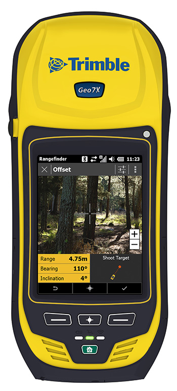
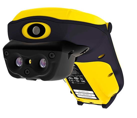
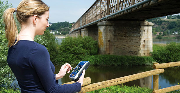
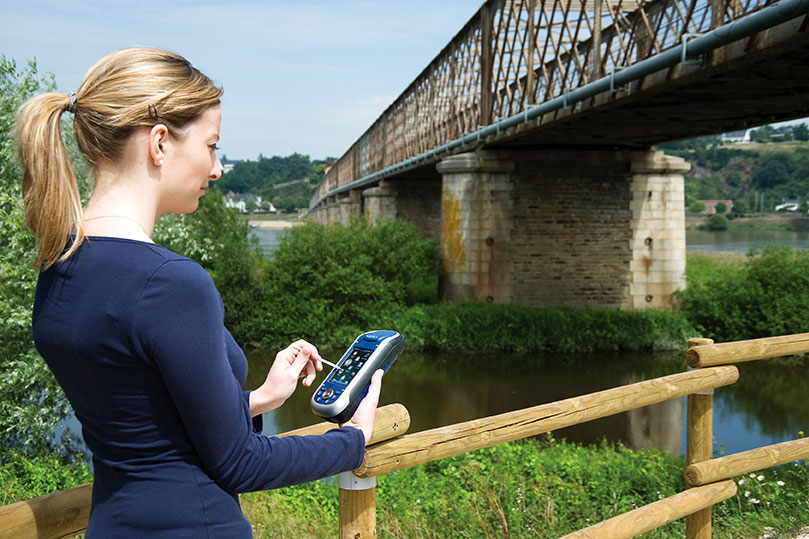
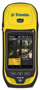
    Trimble has introduced the next generation of its Trimble GeoExplorer data collection solution. The new Geo 7X includes an integrated laser rangefinder module, extended GNSS capabilities and improved hardware performance. Together with robust field and office software, the new Trimble Geo 7X handheld can enhance productivity in difficult physical conditions and challenging GNSS environments.

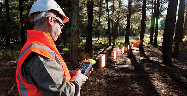
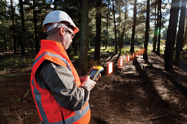
    When faced with either obstructed satellites or inaccessible locations, GIS professionals now have the geospatial data collection tools they need in a single package, Trimble said. For times when occupying a position isn’t possible, users can take advantage of Trimble’s new Flightwave technology. With Flightwave technology, users can capture offset measurements from the Geo 7X’s rangefinder module for direct integration with Trimble data collection software. Users point and shoot to log the position, avoiding dangerous conditions or right-of-way challenges. In addition, Trimble’s field-proven Floodlight technology enhances field productivity when heavy overhead cover obstructs satellite signals.

    Photo: TrimbleThe Geo 7X is compatible with existing and planned GNSS satellite systems — including GPS, GLONASS, Galileo, QZSS and BeiDou — to maximize productivity with additional satellites and ranging signals.

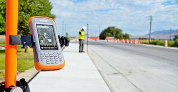
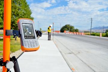
    Featuring a new 1 GHz processor and 4 GB of memory running Microsoft Windows 6.5 Professional operating system, the Geo 7X offers enhanced computing performance. Other standard features include a 4.2 inch sunlight readable LED touch display and a 5 MP camera for geo-tagging assets. For wireless connectivity, the integrated modem allows users to send and receive data via GSM networks as well as Verizon’s CDMA network in the U.S. And with its IP65 rating, the rugged handheld GNSS receiver is sealed against water and dust.

    With the introduction of the Geo 7X, Trimble also delivers updates to its field and office software portfolio to extend Trimble’s end-to-end data collection solutions with new software workflows and compatibility. In addition to the field-proven Trimble TerraSync and Positions software, the Geo 7X now supports the customizable data collection workflows of Trimble TerraFlex software. Consisting of mobile software and Cloud services, TerraFlex offers a fast and efficient way to collect, process and manage data. Field data is automatically synced with a central server to streamline office operations and drive higher productivity.

    ”We believe that true productivity is being able to map assets — the first time, every time and anywhere. We’ve built upon our productivity-enabling Floodlight technology and pushed it forward several steps,” said Alain Samaha, business area director of GIS and geospatial software solutions for Trimble’s Geospatial Division. “Users now can position themselves in the optimal location and accurately measure assets remotely with a single, integrated device together with simple software workflows. The Trimble Geo 7X allows mobile GIS users to be productive wherever they need to work.”

    Photo: TrimbleThe Trimble Geo 7X and supporting software are expected to be available in fourth quarter of 2013 through Trimble’s authorized GIS Distribution Channel.

  • Topcon Adds Vanguard Technology to GRS-1 Receiver

    Photo: Topcon
    Photo: Topcon

    Topcon Positioning Group has added Vanguard technology to the GRS-1 handheld GNSS receiver and field controller.

    “With the addition of Vanguard technology, the GRS-1 fully integrated, dual-constellation, network-enabled receiver and controller optimizes tracking and performance regardless of job site conditions or location,” Scott Langbein, director of product marketing, said.

    Topcon’s 226-channel Vanguard technology with Universal Tracking allows each individual GNSS channel to be fully optimized to track any of the available satellite signals that are supported in today’s GNSS receivers.

    The GRS-1 can be used in various configurations from handheld to network enabled RTK measurement, and grade management. “The system can be configured to perform at various levels of accuracy that fit any budget and application,” Langbein said. Choices include centimeter level, sub-decimeter and sub-meter, with accuracy upgradeability options available.

    Working with Topcon’s Magnet suite of software products, “the GRS-1 streamlines the workflow for surveyors, contractors, engineers and mapping professionals,” Langbein said.

    The GRS-1 with Vanguard has DGPS capability with the internal single frequency antenna for use in GIS and navigation applications. Add the external antenna and connect a GRS-1 rover to a local GNSS network, or Topcon Magnet Relay, for centimeter accuracy RTK performance. Magnet Relay allows a mobile base receiver to host up to 10 rovers through the Magnet Enterprise “cloud.”

    The GRS-1 has an optional 2MP built-in camera, integrated SD memory card slot, and includes an optional internal GSM or CDMA cellular modem and internal GNSS antenna, plus wireless connectivity via wireless LAN or Bluetooth technology.

  • Applanix Adds High-Performance POS Systems to Air and Land Portfolios

    Applanix Adds High-Performance POS Systems to Air and Land Portfolios

    Photo: Applanix
    Photo: Applanix

    Applanix, a mobile mapping and positioning company, has introduced new versions of its positioning and orientation systems for airborne and land-based mapping — the POS AV 610 and POS LV 610.  Delivering the same industry-leading performance as previous versions of POS AV and LV, the new systems use next-generation commercial inertial technologies that are offered globally.

    Applanix POS AV and LV products integrate precision GNSS with advanced inertial technology (accelerometers and gyroscopes) to provide uninterrupted measurements of the position, roll, pitch and true heading of moving vehicles.  Geospatial projects using POS can be completed more efficiently, effectively and economically. The POS AV 610 and POS LV 610 offer new advantages to customers:

    • Global availability: commercial technology.
    • Smaller and lighter: achieved by integrating a new state-of-the-art FOG (Fiber Optic Gyro) based Inertial Measurement Unit (IMU).
    • Exceptional performance with Applanix SmartCalTM software:  SmartCal is a new compensation technology designed to achieve unrivalled performance from IMUs manufactured specifically for mobile mapping applications.
    • Cost efficiency: exceptional accuracy, even in demanding conditions, at unprecedented price points.

    POS LV 610 and AV 610 are also available to systems integrators in the form of an OEM board set called the Trimble AP60. The Trimble AP is a series of embedded GNSS-Inertial OEM boards that provide both continuous mobile positioning in poor signal environments and high-accuracy direct georeferencing of imaging sensors.  The AP series is ideal for a variety of commercial mobile positioning and orientation applications including airborne and terrestrial mapping and guidance for unmanned vehicles.

    “The latest versions of POS LV and POS AV take Applanix’ state-of-the-art positioning technologies worldwide for land and air applications,” said Steve Woolven, President of Applanix. “Wherever mobile mappers operate, the new POS technology provides users with  accurate, reliable and robust position and orientation solutions.”

    POS AV 610, POS LV 610 and Trimble AP60 are available now through the Applanix sales network.

  • Topcon Announces GR-5 with Vanguard Technology

    Topcon Announces GR-5 with Vanguard Technology

    Topcon GR-5 with Vanguard technology.
    Topcon GR-5 with Vanguard technology.

    Topcon Positioning Group has released the GR-5 receiver with Vanguard technology, designed to optimize tracking and performance.

    “The GR-5 is a next-generation GNSS receiver, built on multi-constellation integrated technology pioneered by Topcon,” said Scott Langbein, director of product marketing.

    “Now with the inclusion of Topcon’s exclusive 226-channel Vanguard technology with Universal Tracking, and the power of full-wave Fence Antenna technology that provides multipath rejection in difficult environment, the GR-5 operates with unsurpassed sensitivity, tracking accuracy and performance.”

    In addition to Universal Tracking, Vanguard technology includes Quartz Lock Loop for signal processing in heavy vibration applications and Intelligent Tracking Optimization to select the best combination of available satellite signals.

    “At any time, end-users can track all available satellite signals and be assured of getting accurate measurements regardless of environmental conditions,” Langbein said.

    Additional features of the GR-5 include:

    • Cellular and radio: The GR-5 has both cellular and radio communications, which allows it to be used in radio-based RTK and network RTK systems;
    • Long-range UHF radio: The top-mounted radio antenna extends the range of RTK radio performance;
    • Operating time: GR-5 hot-swappable batteries are designed for full-day operation;
    • MAGNET Field: MAGNET Field software can be used with the GR-5 RTK system, providing the ability to share data to cloud storage and connect field crews to each other and the office.
  • Spectra Precision Shows off New and Updated Products for Surveying

    Spectra Precision Shows off New and Updated Products for Surveying

    Photo: Spectra Precision
    Photo: Spectra Precision

    Spectra Precision introduced at Intergeo this week new and updated products to expand its portfolio of solutions addressing the needs of the mainstream surveying and construction markets. Intergeo 2013 is a geodesy, geoinformatics and land management trade event being held in Essen, Germany.

    “Earlier this year, we introduced a new reflectorless entry-level total station, the lightweight ProMark 700 RTK Network Rover and the Layout Pro construction layout software suite. With our latest additions, the Spectra Precision portfolio continues to evolve to meet the changing needs of our users,” said François Erceau, general manager of Spectra Precision’s GeoInstruments Business Unit. “Spectra Precision now offers one of the broadest and most complete portfolios of survey and construction products in the industry — from construction lasers and total stations to survey GNSS receivers and GIS handhelds — all from a single supplier that customers can trust.”

    New and updated Spectra Precision products include:

    • Spectra Precision EPOCH 50 firmware 4.81 – now supports RTK positioning using the Chinese BeiDou open service GNSS satellite signals. Adding the BeiDou constellation to the full range of GPS and GLONASS signals already tracked by EPOCH 50 further boosts the capabilities of this GNSS receiver to enable faster initialization and performance, even in conditions where satellite visibility is obstructed due to tree canopy or tall buildings.
    • MobileMapper 120 Decimeter Edition this new kit, based on the MobileMapper 120 handheld GNSS receiver, includes the Flying RTK, GLONASS tracking and NTRIP correction options. With accuracy of 20cm or better, the Decimeter Edition kit is a competitively priced solution for precise Mobile Mapping applications.
      • ProFlex 800 firmware version 1.9 – now supports GLONASS-only mode and tracking of QZSS signals to meet the needs of specific markets (Russia and Japan, respectively). This updated firmware also improves RTK performance in VRS networks, particularly in challenging GNSS environments, through Z-Blade technology enhancements.
    • Layout Pro Field and Office software – a recent release of the Layout Pro field software added support for the FOCUS 30 Robotic Total Station, offering the highest level of productivity and accuracy in a construction layout solution. The Layout Pro version 2.1.1 update now includes language packs for major markets worldwide, in addition to many other minor enhancements. Customers with a current Layout Pro maintenance agreement are eligible to download this update from www.spectraprecision.com.
    • Survey Basic software for total stations – further enhancements to this entry-level software application make for the simplest starting point, with workflows that mirror the familiar Nikon-style FOCUS 6 user interface in a modern full-color touch-screen instrument (FOCUS 8). Further language packs have been added, including Czech, Traditional Chinese, Korean and Polish.
    • Survey Pro Field software version 5.4 –  the latest release of this award-winning survey field software includes many new features and enhancements such as:
      • Updated Digital Terrain Model (DTM) features and interface
      • Support for new GNSS constellations and an improved GNSS workflow
      • Additional Active Map enhancements that make it easier than ever to work directly from the map screen
      • Updated point staking routines and a new interface for building design point lists
      • A new Plane and Vertical Angle Offset routine
      • A new electronic compass display in various map screens
      • Enhanced total station and GNSS setup routines
      • An improved Code/Description entry and display system

    Customers with a current Survey Pro maintenance agreement are eligible for this update and can download the software from .

    • Spectra Precision Survey Office software v3.10 and v2.95 ­– both versions are companions to Survey Pro 5.4 field software and FAST Survey field software, and offer enhanced baseline processing with more reliable outlier detection and improved accuracy statistics. Additionally, version 3.10 features a new customized ribbon UI and is optimized for 64-bit PCs (with notably faster processing).

    These new and updated Spectra Precision products are now available for order through the Spectra Precision global reseller network.

  • Juniper Systems’ New Rugged Handheld Features 4.3-Inch Touchscreen

    Juniper Systems’ New Rugged Handheld Features 4.3-Inch Touchscreen

    Photo: Juniper Systems
    Photo: Juniper Systems

    Juniper Systems has announced the availability of a new rugged handheld, the Archer 2. With radical improvements over the first generation Archer, the Archer 2 promises better overall performance with an astonishingly bright display, an extra-long battery life, enhanced GPS capabilities, and rugged IP68 construction.

    Juniper Systems will be showcasing the Archer 2 at the Intergeo 2013 conference from October 8-10 in Essen, Germany.

    According to the announcement, the latest generation handheld incorporates several new technological advancements. Sporting a custom 4.3-inch Illumiview high-visibility display, the Archer 2’s screen brightness has been well received by reviewers. Its battery features a unique technology inspired by the technology used in hybrid car batteries to prevent excessive battery drainage in low temperatures. Referred to as Overtime Technology, this Archer 2 super battery will last 20 hours and up on one charge.

    The new device is the first Juniper Systems handheld to feature a capacitive touchscreen for improved response and ruggedness. The Archer 2 also includes a glove-friendly numeric keypad for rapid data entry, a feature which many Juniper Systems customers highly value. Like other Juniper Systems handhelds, the Archer 2 is built to very strict standards at its ISO 9001:2008-certified facility, having been tested to MIL-STD-810G and given a top IP68 rating for dust and water.

    Photo: Juniper Systems
    Photo: Juniper Systems

    “We have been looking forward to the release of the Archer 2 for some time,” said Rob Campbell, CEO at Juniper Systems. “We have taken special care in addressing the needs of customers in the design of the Archer 2. It is a product of utmost quality, and the excellent reviews we have received on our Archer 2 beta units have made us very optimistic that the Archer 2 is going to meet our customers’ needs exceptionally well.”