Trimble introduced today the latest version of its deformation monitoring software, Trimble 4D Control version 4.2. The new version of the monitoring software delivers enhanced communications with the Trimble NetR9 and new NetR9 Ti-M GNSS receiver, REF TEK seismic sensors and the Trimble S8 total station. It also supports geotechnical sensors, weather stations, level data and it provides velocity and trend computations as well as a calculation facility for mathematical operations. The interactive Web interface provides advanced alarms, data visualization and analysis tools. Site access is controlled by user login credentials.
The announcement was made today at Intergeo 2013, being held in Essen, Germany, October 8-10.
Trimble NetR9 Ti-M. Trimble also introduced a dedicated GNSS monitoring receiver, the Trimble NetR9 Ti-M, designed for real-time monitoring applications. This instrument is the fourth-generation of the proven Trimble NetR9 series of GNSS reference receivers, and is specifically designed for the monitoring market and supported by Trimble 4D Control software.
Trimble REF TEK Sensors. Following the acquisition of REF TEK, now a division of Trimble and a provider of seismic sensors and data recording instruments, support for REF TEK accelerometers has been included in Trimble 4D Control version 4.2. Different variants of peak acceleration that are used in monitoring the effects of vibration on structures such as micro-seismic activity, proximity blasting or impact piling can be visualized and alarmed in Trimble 4D Control.
Trimble 4D Control is a fully scalable and comprehensive software solution for both real-time and post-processed monitoring projects. The software solution is ideal for the long-term, automated monitoring of dams, bridges, buildings, support piers, large-scale construction and excavation sites, open pit mines, landslides, tunnels and other structures. Real-time management and control of the monitoring system is available via the Trimble 4D Control Web Interface on-site, online and around the clock from any location with Internet or Intranet connectivity.
“To date, this advanced technology has only been available to end users of an automated monitoring system. We recognized the need to provide this functionality across the full spectrum of monitoring applications,” said Ulrich Vollath, general manager of Trimble’s Infrastructure Division. “We are pleased to announce the launch of Trimble 4D Lite, a cloud-based subscription service which will make this solution available to small- and medium-sized monitoring projects. With the introduction of 4D Lite, Trimble’s monitoring solutions are now available for the full spectrum of monitoring projects, from small, non-permanent, campaign monitoring projects through to permanent, fully automated monitoring systems.”
Trimble 4D Lite – Advanced Cloud Monitoring Service. 4D Lite is a cloud-based application that is designed with an interface familiar to existing Trimble monitoring technology users. 4D Lite is designed for surveyors, engineers and scientists to perform campaign monitoring of data/time series without the need to integrate directly with onsite hardware and sensors. Trimble 4D Lite can be used to meet campaign monitoring needs of installations on dams, bridges, mines, landslides, buildings and other natural and man-made hazards or structures using sensors to monitor health. Data can be integrated from a wide range of sensors. The data can be visualized and analyzed on a variety of interactive charts and scatter plots and the sensors can be viewed in context with the structure using a variety of backdrops including maps, plans or photographs.
Trimble 4D Control version 4.2, the NetR9 Ti-M GNSS receiver and the 4D Lite monitoring service are available now from Trimble’s worldwide Infrastructure distribution network.
Trimble announced today several enhancements to the Trimble R10 GNSS Surveying System designed to drive field productivity to a new high. With sophisticated tilt-compensation technology, CenterPoint RTX correction service support, and updated field and office software, the R10 platform demonstrates Trimble’s commitment to driving improved surveying productivity.
The announcement was made at Intergeo 2013, being held October 8-10 in Essen, Germany.
“Innovations in techniques such as our tilt compensation technology can have a pervasive impact on the everyday surveying experience,” said Elmar Lenz, business area director of GNSS Solutions for Trimble’s Geospatial Division. “With our innovative approach to total surveying workflow, Trimble is redefining the way surveying work is done.”
The Trimble R10 is now augmented to further speed GNSS field work. With its new internal tilt-compensation, Trimble SurePoint technology takes field efficiency to the next level. The system will automatically adjust for pole-tilt up to 15 degrees from plumb, saving time and reducing fatigue. With tilt compensation, surveyors can now utilize GNSS in more situations and with 100 percent measurement traceability.
In addition, Trimble introduced its high-accuracy correction service, CenterPoint RTX, into the geospatial market with support in the Trimble R10. Powered by Trimble RTX technology, CenterPoint RTX is a subscription service that delivers real-time 4 centimeter (1.5 inch) or better corrections via satellite directly to the receiver without requiring the use of a base station, VRS network, or investment in additional hardware.
Both Trimble Access field software and Trimble Business Center office software have been updated to streamline data flow and automate data processing. Faster in the field and more flexible in the office, Trimble’s premium GNSS surveying system enhances the entire surveying workflow.
The updates to Trimble R10 GNSS System, CenterPoint RTX service support, Trimble Access version 2013.40 and Trimble Business Center version 3.10 are expected to be available in the fourth quarter of 2013 through Trimble’s Geospatial Division distribution network. For current R10 users, the tilt-compensation feature and CenterPoint RTX support will be available through a free firmware update.
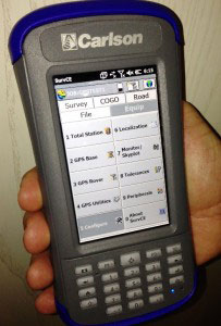
Carlson Software Inc. has developed the new Carlson SurveyGNSS post-processing program, which it introduced today at Intergeo 2013, being held in Essen, Germany. The program is designed for surveyors and positioning professionals looking to achieve centimeter accuracy when working on the edge of their RTK infrastructure, perform sub-centimeter positioning, or provide the highest quality assurance to their customers.
The data post-processing solution is tightly integrated into the Carlson field and office workflow. SurveyGNSS is designed to accept GNSS data from any receiver in RINEX format. Furthermore, it will also accept proprietary GNSS data in an increasing number of manufacturer formats including NovAtel, Hemisphere GNSS, Altus/Septentrio, and Javad. Additional manufacturer formats will be added in concert with manufacturer cooperation and customer demand.
“The software has been tested extensively on data sets from around the world with very good results and feedback,” says Bruce Carlson, president of Carlson Software. “Many of our business partners are planning to carry SurveyGNSS and have participated in our pre-release testing.”
Carlson SurveyGNSS will process GNSS observations in traditional static, “stop and go” (static-kinematic), and kinematic (moving) antenna positioning modes. The software provides a straightforward, workflow-oriented user interface, which includes an overview map and the observation files, computed vectors, and positions presented in fully functional spreadsheet-like grids.
In addition, Carlson SurveyGNSS provides:
A highly autonomous “hands-free” baseline processor offering on-the-fly ambiguity resolution, automated cycle slip detection/removal, and more for baselines up to 200km (125 mi).
Automated search and retrieval of reference geodetic control and GNSS observations from public data sources such as the National Geodetic Survey and Continuously Operating Reference Station (CORS) networks in the United States.
Rigorous least squares adjustment and analysis of all computed vectors.
Seamless integration with downstream applications from Carlson Software and other vendors.
Carlson SurveyGNSS is being developed in partnership with WaSoft of Dresden, Germany, and its line of GNSS software technologies.
“SurveyGNSS helps make our survey product line the most extensive in the industry, from field data collection through all forms of processing to as-built mapping and plat drafting,” Carlson adds. “Our flexible licensing arrangements allow single users to process the field data of any number of crews using a wide range of GNSS equipment.”
Announced at Intergeo in Essen, Germany, Carlson SurveyGNSS is slated to be available from your local Carlson representative or dealer by December 1.
Trimble announced today that its Trimble CenterPoint RTX correction service will be available to survey and land administration professionals around the world. Powered by Trimble RTX technology, the GPS, GLONASS and QZSS enabled correction service can offer better than 4 centimeter (1.5 inch) repeatable horizontal accuracy, without requiring the use of a base station or local VRS network.
The announcement was made today at Intergeo 2013, being held this week in Essen, Germany.
In addition to previously announced Agriculture devices, the CenterPoint RTX correction service is now compatible with the Trimble ProXRT for Land Administration and the Trimble R10 GNSS receivers. The worldwide subscription service is expected to be available to geospatial users in the fourth quarter of 2013.
Delivered via L-band satellite, CenterPoint RTX is designed for geospatial professionals who are not using RTK as the primary correction source. Advantageous in remote areas that lack local infrastructure and/or cellular coverage, the corrections are delivered directly to the GNSS receiver. No additional hardware, including radios, antennas, or even cellular data plans, is required to use the correction service.
“By combining global coverage, fast initialization times, and high-accuracy correction data, Trimble CenterPoint RTX offers geospatial professionals unprecedented operating freedom,” said Patricia Boothe, general manager of Trimble’s Positioning Services Division. “We are committed to offering field-proven positioning corrections to address a variety of users’ needs across applications and markets, starting with agriculture and now reaching into the geospatial markets.”
Carlson Software has introduced a new and improved version of its affordable Qmini data collector. The rugged, but lightweight Qmini2 provides fast processing, yet fits comfortably in one hand.
Carlson also launched the Carlson MINI2 data collector, which is more rugged, fast, and reliable than its predecessor. It comes with a numerical keyboard for easy coding of points.
Both products were introduced at Intergeo, being held October 8-10 in Essen, Germany.
Photo: Carlson Software
The Qmini2. Weighing 11 ounces (315 grams), the Qmini2 includes a 5 megapixel camera and has a 3.7-inch (480 x 640) sunlight-readable display and comes with a stylus for ease of use. Other specifications include:
Works on Windows Mobile 6.5 OS with a PXA310 processor 806Mhz, 256 RAM
Provides 8GB non-volatile data storage plus a micro SD card slot
Comes with Bluetooth (200-250 meter range to CRx with BT handle), WiFi, Internal GPRS module (data and voice) capabilities
Has an internal 32-channel GNSS receiver (GPS + GLONASS) with SBAS (WAAS, EGNOS, MSAS) support
Rated IP65 waterproof and dustproof
The Qmini2 comes with two batteries, a U.S. wall charger, and a soft carrying case. It may be purchased with Carlson’s SurvCE data collection software on board, or with Carlson GIS360, which uses both GIS and surveying technology in the field to collect data. For crash or crime reconstruction, The Qmini2 may also be used with Carlson’s CSI Mobile software.
For more information or to see the Qmini2 in action, stop by the Carlson Stand #3.097, Hall C, or outdoors at #100 at Intergeo, Oct. 8-10 in Essen, Germany.
The Carlson MINI2.
The MINI2. Manufactured to Carlson’s exacting specifications by Juniper Systems, the MINI2 has an extra-large 800 × 480 TFT display for easy viewing of survey data and comes with a fast 1.0-GHz processor. It comes with an integrated 3G modem, 5-megapixel camera, and GPS/GNSS module.
Its scratch-resistant, touchscreen display is highly readable in both low light and glaring sunshine, providing a sharper image together with notable durability in tough conditions. With a dustproof and waterproof rating of IP68, the Carlson MINI2 also meets the MIL-STD-810G military standard.
The Qmini2 will be available for purchase from your local dealer on November 1.
Both products can be viewed at Intergeo Stand #3.097, Hall C, or outdoors at #100. at Intergeo.
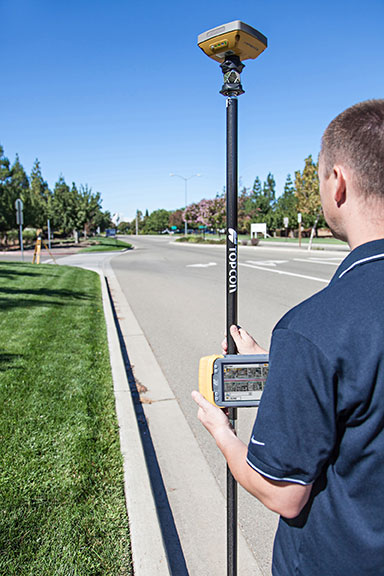
Topcon Positioning Group announces a new technology — Hybrid Positioning — that increases efficiencies and improves productivity on job sites, regardless of conditions, terrain or location. Hybrid Positioning is enabled through the Topcon Magnet software suite, a Topcon enterprise solution for the geomatics industry.
The new Topcon technology allows precise positioning professionals in the survey, construction, civil engineering and GIS industries to simultaneously connect to GNSS signals and standard robotic measurements on a single rover pole.
“This extremely clever and unique combination of GNSS and optical measurement is aimed squarely at improving a company’s profitability by allowing the use of GNSS positioning and optical positioning data at the same time,” said Ewout Korpershoek, chief marketing officer of Topcon Positioning Group. “When used with Topcon Magnet software, Hybrid Positioning improves field measurement efficiency at every phase of a project. With Hybrid Positioning technology, the key is versatility. For example, when line-of-sight is blocked, shots can be easily and quickly measured with the GNSS receiver. Now it is so easy to combine a standard Topcon robot and GNSS receiver to guarantee an integrated solution for the highest performance and productivity.
Photo: Topcon Positioning Group
“Combine these two proven solutions, plus advanced Magnet Field software, and you have Hybrid Positioning technology,” Korpershoek said. “By utilizing both GNSS and optical measurement, any project can be completed faster and with unsurpassed accuracy. By adding Magnet cloud-connected data workflow, truly outstanding increases in productivity and cost savings are assured.”
The new technological breakthrough has four key components: Hybrid Lock, Hybrid Resection, Hybrid Switch and Auto-localization.
Hybrid Lock allows accurate prism tracking by simply turning the instrument toward the prism location. Hybrid Resection ensures quick job site setup, as well as establishing RTK and geodetic coordinates. Hybrid Switch ensures a quick changeover from GNSS to optical measurement with a single touch. Auto-localization utilizes Bing Maps background, multi-point localization and works with RTK and NMEA positioning.
“Regardless of job site location or adverse conditions or terrain, Hybrid Positioning systems will perform faster in the field than other instruments and with more versatility than an RTK-only system,” Korpershoek said.
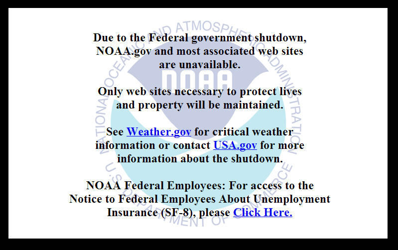
On October 1, the U.S. federal government shut down and furloughed 800,000 non-essential workers. While services considered essential remained active, those considered non-essential services, like the National Geodetic Survey’s Online Positioning User Service (OPUS), were shut down. OPUS is a free, online GPS post-processing service. If you try to access www.ngs.noaa.gov, the following screen will be displayed:
For those of you who rely on OPUS for GPS post-processing, now is a great time to try one of the other seven online post-processing services available and not subject to the U.S. federal government. Yes! I wrote seven, and the results from those seven are comparable to OPUS. The other seven, free online GPS post-processing services are:
CSRS-PPP: Canadian Spatial Reference System, Natural Resources Canada
My colleague Mark Silver, creator of the X90-OPUS receiver I wrote about a few months ago, embarked on an effort to run test data through each of the online post-processing services to demonstrate that there are free, online GPS post-processing services available worldwide that produce results comparable to OPUS. The following report is the result of his efforts:
A Comparison of Free GPS Online Post-Processing Services
By Mark Silver
You are probably familiar with the National Geodetic Survey’s OPUS suite of online post processing tools (OPUS-Static, OPUS-Rapid Static and OPUS-Projects.) These services are capable of producing centimeter-level positioning from static GPS observations. What you may not realize is there are at least six viable alternatives to OPUS.
All are free, easy to use, provide world-wide coverage, and generate surprisingly similar results.
Since each uses a unique baseline tool and processing strategies they form an excellent reality check against each other.
IGS orbits and the IGS permanent CORS arrays are used by many of the services, however some use proprietary equipment arrays and orbit products that provide additional redundancy.
How comparable are these services? Which one is the best?
Criteria for Comparing
Comparing results is a difficult proposition:
The true/correct answer for any site is unknown.
What grading scale should be used? Should elevation differences be weighted differently than horizontal differences?
Should the peak-to-peak range or the standard-deviation be prized?
Should comparisons be made on long 24-hour data sets or short 2-hour occupations?
Is a single data set sufficient for a meaningful comparison or are multiple data sets preferable?
Should a service be ‘thrown out’ of consideration because the solutions are substantially different from the mean?
The answer to all of these questions is “it depends.” Your evaluation will depend on your specific application.
For this evaluation, the following rules governed the data set selection:
Choose a site known to be stable with a clean EMI environment.
Use 24-hour observation sets to enable ‘best case’ processing.
Use a sufficiently large data set, 32-consecutive days, to expose trends.
Choose a time period, 90-days in the past, so precise orbits are available to reduce ephemeris effects.
Only consider GPS data.
Use default settings for every option on each processing service.
Scoring
This would not be as interesting without a little competition.
To keep the evaluation simple, the sum of the X, Y and Height range will be the score and the services will be ranked from lowest score to highest score, with the low score being the ‘best.’
Range was chosen as an indicator of the expected maximum error that might be encountered if only a single 24-hour file was observed.
The combined range rewards a processing scheme that best estimates delays, interference, clock errors and other sources of change that occurred during the 32-day trial.
Remember that the every aspect of this ‘competition’ is arbitrary: from the selection of observation sets, to the final scoring system.
The real take-away from this evaluation is not that one service is better, but how close all of the services are to each other.
Two services (JPS’s APPS, magicGNSS) won’t be acceptable to the average user and a third (RTX Centerpoint) may not work for some users based on receiver and antenna support. Details of these problems are presented with the service descriptions below.
The Test Data
SGU1 in St. George, UT USA was chosen as the observation base. The observations consist of 32 consecutive days (May 3, 2013 through June 3, 2013), 24-hour observation files, 30-second interval, GPS only data. The data files were downloaded from the NGS CORS archive.
Each of the 32 files were submitted to each of the processing services and the results have been tabulated for X, Y and Ellipsoid Height. All data is presented in IGS08 current epoch framed coordinates. All data has been projected to UTM Meters for these comparisons.
The Average Values
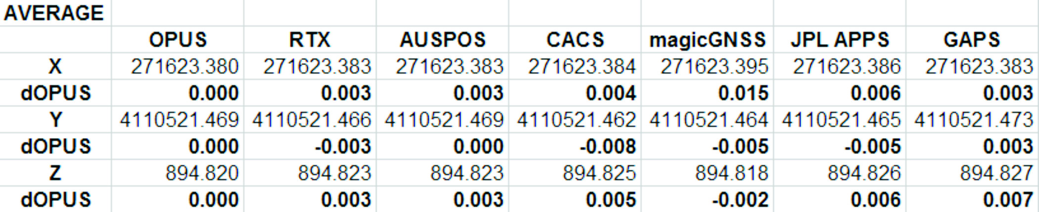
Remember, the real story is how close each of these services produce results to one another. Let’s look at the average positions from each service and the difference from OPUS:
Fig 1: Average Solution Difference from OPUS
As you can see in Figure 1 above, the services were generally within 5mm of OPUS in X, Y and Height.
Position Tracking vs. Time
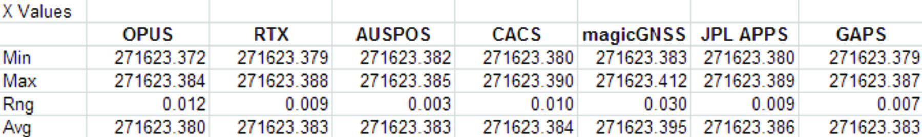
Fig 2: Service Results X vs. Time
Fig 3: Service Results X Range, Average
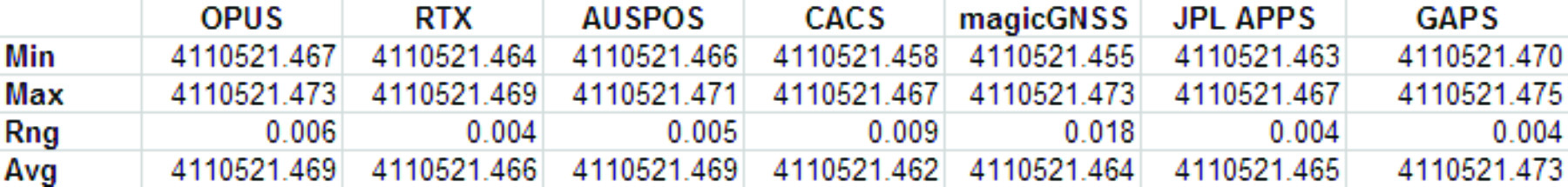
Fig 4: Service Results vs. Time
Fig 5: Service Results Y Range, Average
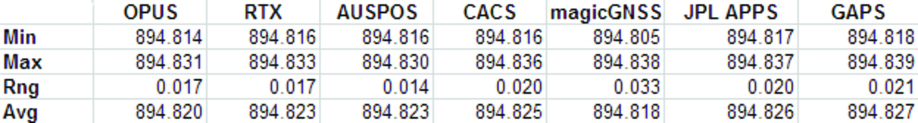
Fig 6: Service Results Z vs. Time
Fig 7: Service Results Z vs. Time
And the Winner Is…
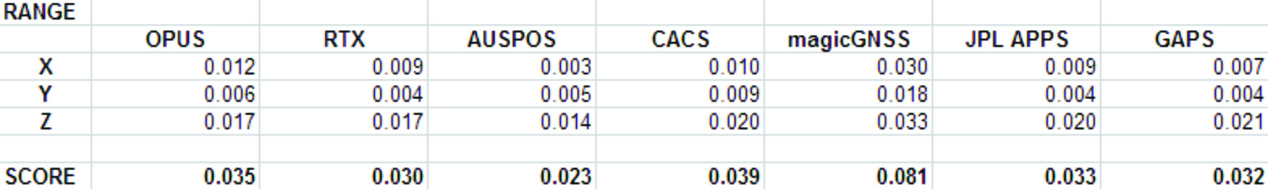
Following are the scores, based on the combination of X, Y and Height range:
Fig 8: The Scores
Score ranking (remember this is just for fun as the services provided remarkably similar results):
AUSPOS
CenterPointRTX
GAPS
APPS
OPUS
CSRS-PPP
magicGNSS
There is a significant issue in the JPL APPS’s reported output positions, which will keep it from being of any use to most users. magicGNSS’s results are significantly different than the other services. User’s should independently evaluate magicGNSS’s suitability for their purpose. SOPAC’s SCOUT could not be evaluated because it patently does not support either the receiver or antenna that was used at the test site.
AUSPOS is a free service from Geoscience Australia. Access is via a simple web interface, the antenna height and type are entered along with a email address for the returned report set. File submission is via FTP or directly from the web interface.
The returned PDF report is the best looking of the reviewed services and includes a Processing Summary showing a map of the CORS sites that were used in the solution. SINEX files are also available.
AUSPOS uses the Bernese GNSS Software for processing baselines, IGS orbits and IGS network stations. Solutions are available for anywhere on the earth.
RINEX files need to be at least 1-hour in length, 6-hour files are recommended. Compact RINEX files are also accepted. Files may be compressed with UNIX, Hatanaka, ZIP, gzip or bzip compression.
Centerpoint RTX Post Processing: Trimble Navigation Limited
CenterPoint RTX Post Processing is a free service offered by Trimble.
It works anywhere in the world and is based on a proprietary Trimble 100+ worldwide CORS network. Accuracy is 2 cm with 1-hour of observation data; 1 cm with 24-hours. Files longer than 24-hours are not accepted.
RTX uses GPS, GLONASS and QZSS tracked SV’s.
The reported output frames include ITRF2008 at current epoch and a user selectable frame like NAD83/2011 2010.0. RTX is one of the few services that will directly export NAD83 framed results.
A single page PDF and a XML result file are returned by RTX. Unfortunately, it is not possible to copy numerical results from the read-only PDF result file to the clipboard.
RTX supports a limited number of receivers (Trimble) and a relatively small subset of IGS modeled antennas. For this test, TEQC was used to stuff the RINEX headers with a comparable Trimble receiver to the actual Ashtech ProFlex 500 receiver that is in use at SGU1. This was all that was required to spoof an accepted device. If the antenna had not been listed, it would have been necessary to spoof the antenna and adjust the height to reflect the difference in L1 phase center offset.
GAPS is an ongoing project at the University of New Brunswick and was developed by the Department of Geodesy and Geomatics Engineering.
File submission is by a web page and GAPS provides a large number of user inputs and potentially allows the highest level of customization of any of the reviewed services:
You may enter a priori coordinates, and a priori constraints
GAPS accepts static or kinematic files
You can set the elevation mask
The Neutral Atmosphere Delay model is selectable
Earth Body Tides and Ocean Tidal Loading can be applied or disabled
GAPS only processes GPS data (no GLONASS.)
Submitted filenames must adhere to the SSSSDDDh.YYt file format. GAPS accepts RINEX and compact RINEX files, they may optionally be gzip, unix compressed or ZIP compressed.
WARNING! APPS only reports the derived position to the nearest decimeter-meter in geographic (lat/lon) coordinates, while reporting ECEF coordinates to a fraction of a millimeter. If you choose to use APPS, you will need to manually convert the ECEF XYZ to geographic coordinates.
JPL’s APPS is based on GIPSY-OASIS (currently version 5). APPS uses NASA’s 70+ Global GPS Network plus densification from other systems (100+ total receivers distributed globally.) Solutions are typically available with 5 seconds delay from observation.
APPS is easy to use, you just specify a file to upload and then click on ‘Upload’ it takes only 15 seconds to get a result after the file upload is complete. You can optionally register for a free account and use email or FTP for bulk uploads.
APPS also has receiver Live Performance Monitoring: (http://www.gdgps.net/monitoring/index.html) which generates a real time graph of three receivers spread through the world.
Before using CSRS-PPP, you will need to register for a free user account.
CSRS has a fantastic desktop application named PPP-Direct that you can just drag and drop files onto. PPP-Direct automatically submits the file and saves all typing, greatly reducing the chance of error.
CSRS-PPP uses both GPS and GLONASS (if available) observables. Ocean Title Loading corrections can be overridden.
CSRS-PPP will accept single frequency files for processing. CSRS will accept RINEX and Compact RINEX, and will decode ZIP, GZIP and unix compression formats.
CSRS-PPP has a fantastic PDF report, a .csv file detailing results epoch by epoch and a great machine readable summary file.
The desktop submission tool, coupled with the great output reports made CSRS-PPP my favorite tool.
magicGNSS accepts emailed files and returns solutions by email. Turnaround time is fast and features a nice PDF report plus SINEX, receiver clock bias files, tropospheric delay, KML trajectory and RINEX CLK clock bias files.
Static and kinematic files with observations from GPS, GLONASS are processed by magicGNSS and the service reportedly Galileo-ready.
magicGNSS uses a subset of IGS stations to provide core coverage.
SCOUT: Scripps Orbit and Permanent Array Center (SOPAC). University of California, San Diego
Scout accepts RINEX and compact RINEX files, compressed (Z, gz, ZIP) submitted from an FTP site or pushed onto a provided FTP server.
Files must be generated on a limited subset of receivers and antennas. While the IGS antenna and receiver files are the basis for acceptable devices, not all IGS-listed devices are on the allowable device list. SCOUT documentation specifically warns against spoofing devices and antennas.
SCOUT uses the GAMIT processing engine.
Because the test data for this article is from a unsupported receiver and the submittal process requires a FTP host server with anonymous access which most users will not bother with, the output from SCOUT was not evaluated.
Conclusion
The similarity of results between all of the services I processed is amazing. That they differ only by millimeters demonstrates the robustness of the algorithms and processes they use.
The difference between AUSPOS, RTX, GAPS, OPUS and CSRS-PPP solutions are negligible. For important positioning projects, it undoubtedly makes sense to use them all.
For locations in the United States, OPUS and RTX return NAD83-2011 framed results. Only OPUS returns derived orthometric heights using GEOID12A. While OPUS has more provenance than the other services, it is easy enough to submit important observations to multiple services as a reality check for important positions.
###
As you read from Mark’s report above, even though OPUS is shut down until the U.S. Congress can resolve its differences, don’t let that stop you from processing your GPS static sessions. However, some level of due diligence on your part is needed as requirements vary for each service. For example, static sessions for the OPUS-RS service can be as short as 15 minutes while other services require two hour GPS static sessions. Furthermore, some services process GPS L1 data while others require both GPS L1 and GPS L2 observations.
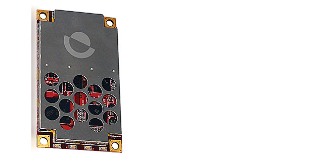
Today, Hemisphere GNSS introduces the Eclipse P306 and P307, the latest models in the Eclipse series. The Eclipse P306 and P307 track multi-frequency GPS, GLONASS, and BeiDou satellite signals and are Galileo and QZSS ready. By tracking more signals, RTK positioning performance improves especially in challenging environments.
The Eclipse P306 and P307 are the first products to utilize the company’s new SX4 ASIC. Capable of simultaneously tracking code and phase signals on 89 satellites, SX4 boasts 372 channels and can be configured to address several diverse applications through software.
Smaller than a business card, the Eclipse P306 upgrades existing designs using Hemisphere’s standard 34-pin modules. The Eclipse P307 is a drop-in upgrade for designs based on the industry accepted 20-pin module. Both products offer scalable performance. RTK accuracy is achieved in either single- or dual-frequency mode. When subscribed for multi-frequency, multi-constellation RTK, Eclipse receivers have fast RTK initialization times even over long distances.
“While the Eclipse P306 and P307 provide outstanding RTK performance,” commented Dr. Mike Whitehead, Chief Technology Officer of Hemisphere GNSS, “non-RTK users benefit from our COAST, SureTrack, and HeadStart technologies.” COAST and SureTrack work together to maintain sub-meter positioning for 40 minutes when differential corrections are lost. HeadStart reduces the occurrence of cold starts by keeping time while the receiver module is powered off, providing faster startup times.
Support of the Chinese BeiDou GNSS constellation is significant. The BeiDou constellation not only fully covers China, but extends beyond, covering 2/3 of the world’s land mass, benefiting 5.8 billion people. Coverage currently includes Asia, Australia, New Zealand to South Africa, Europe and all of Russia, as well as Hawaii with, on average, three or more BeiDou satellites visible above 15°.
In February 2013, Hemisphere GPS changed its name to Hemisphere GNSS, Inc., after parting ways with its agriculture unit. While both names are owned by the company, in order to reflect the company’s support of all GNSSs and update the company’s image, “Hemisphere” has been adopted as its brand name. The company also has adopted a new logo and has launched an updated website, www.HemisphereGNSS.com.
Hemisphere will be introducing the new Eclipse P306 and P307 OEM positioning modules at the annual Intergeo conference in Essen, Germany, October 8th-10th, 2013 at Booth #A3.070.
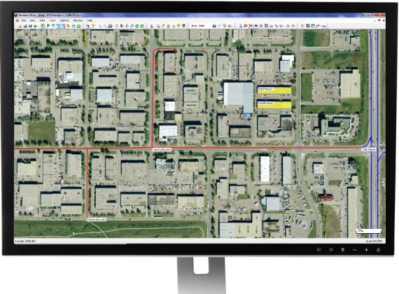
Nexteq Navigation has officially released the next version (V2.0) of its GIS data collection suite, NexGeo. The suite consists of a mobile application for GNSS handhelds to collect and organize GIS data, as well as a desktop application used to customize and organize projects, manage field crews, and integrate with other data formats.
NexGeo aims to provide a complete solution, from augmenting accuracy to a user-friendly, efficient data-collection tool. An improved user interface provides seamless access to Nexteq’s positioning algorithms, notably in the PPP field, including SBAS-based Freedom algorithm, Internet-based i-PPP global services, and traditional RTK, all available in the field as well as post processed where necessary.
The latest version of the software contains a slew of improvements and new features, Nexteq Navigation said. NexGeo Mobile on the handheld is redesigned to provide intuitive shortcuts to the software’s main functions directly on the dashboard, simultaneously presenting a panoramic view of working mode, data quality, and handheld status. Improvements of NexGeo Mobile include pausing and resuming features, quick navigation to preset waypoints with compass or map view, offset feature collection using data from a laser rangefinder, and enhanced options of Feature Cloning, Filtering, and Updating.
When managing projects, post processing the data and tracking the field operation in NexGeo Office, the new interface, including comparison and review tools to customize results, significantly improve the capability of project management and post data analysis. A new coordinate system manager offers an easy way to set up customized coordinate systems.
Besides all the functional changes made to NexGeo, the software suite has received a complete interface overhaul, as well as improvements to loading times and performance. Experienced users will remain at home with the NexGeo feel, as the backbone of the software suite has not changed. All existing projects are compatible with the new versions.
In keeping with Nexteq’s commitment, NexGeo v2.0 is available for free download for all existing authorized clients. For users interested in trying out the NexGeo experience, demonstrations can be provided by contacting [email protected].
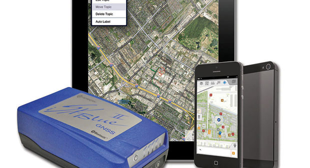
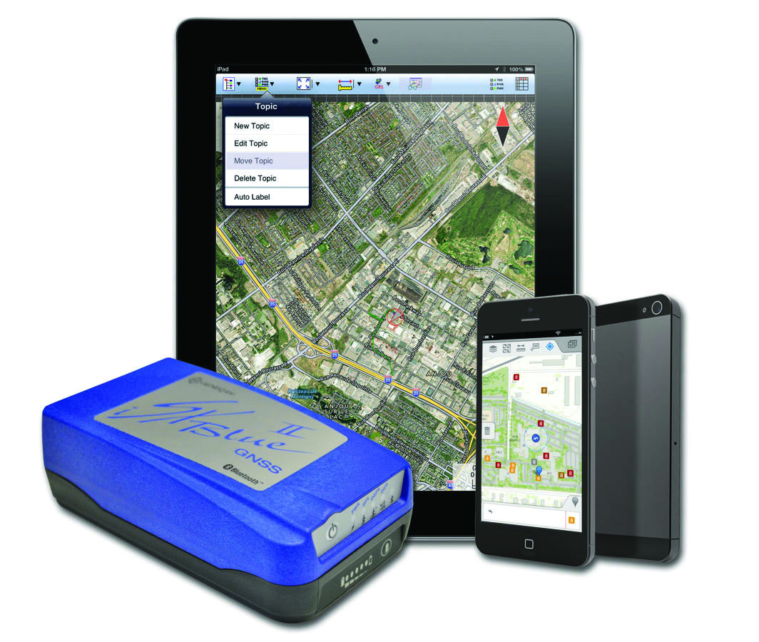
The iSXBlue II from Geneq works with the Apple iPad and iPhone.
Geneq Inc. announces the iSXBlue II GNSS, a sub-meter GNSS receiver that is Bluetooth-compatible with Apple iPads and iPhones.
Fully authorized and approved by Apple, the iSXBlue II GNSS implements an Apple proprietary Bluetooth authentication feature allowing the NMEA GNSS data to replace the internal GPS location of the iPad or iPhone. A free SDK (software development kit) is available from Geneq to further utilize all the features of the iSXBlue II GNSS.
The iSXBlue II GNSS uses both GPS and GLONASS with SBAS (WAAS/EGNOS/MSAS/GAGAN) to attain 30-cm/1-foot (RMS) accuracy in real time using free SBAS corrections. In addition to Apple iPads and iPhones, it connects wirelessly to any smartphone, handheld, tablet computer or notebook computer that is Bluetooth- compliant.
“The iSXBlue II GNSS is the first high-accuracy GNSS receiver in the world for the Apple iPad and iPhone,” said Jean-Yves Lauture, product engineer, “and by implementing both GPS and GLONASS with SBAS, it provides iPad and iPhone users real-time, sub-meter accuracy around the world.”
The iSXBlue II GNSS builds on the success of the proven SXBlue II GNSS that was designed to optimize SBAS performance under tree canopy and in rugged terrain. With the ability to track 55 satellites (31 operational GPS, 24 operational GLONASS), the SXBlue II GNSS uses between 12 and 19 satellites in view at any time, providing superior performance when working under and around tree canopy, buildings and rugged terrain.
The next-generation iSXBlue II GNSS is the same, small, palm-sized unit as the SXBlue II GNSS and utilizes a small 2.7” diameter GNSS antenna. The unit is waterproof (submersible), dustproof and ruggedized, with an IP-67 rating. Its Class 2 Bluetooth 2.0 has a typical range of 15 meters, and is Apple-approved. The internal, rechargeable, field replaceable Li-Ion battery has on-board LEDs let the user know how much battery life is left. The operating temperature range of the iSXBlue II GNSS is -40°C (-40°F) to 85°C (185°F).
In addition to the built-in long-range Bluetooth transceiver, the iSXBlue II GNSS also has a standard DE-9 RS-232 port and a USB Type B port whose outputs are fully programmable up to 10-Hz standard, and a 20-Hz option. Other optional features are L1 RTK for <2-cm real-time accuracy and base-station RTCM output.
There is no need for post-processing or other sources of differential corrections as the iSXBlue II GNSS uses WAAS (North America), EGNOS (Europe), MSAS (Japan) and GAGAN (India) satellite corrections. Users receive real-time, 30-cm/1-foot positioning all day long.
The iSXBlue II GNSS is targeted at GPS/GIS mapping professionals in industries such as forestry, utility, agriculture, environmental and other natural resource industries in addition to local, state and federal government users.
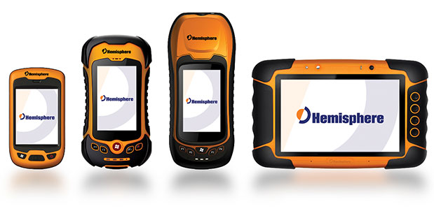
Today, Hemisphere GNSS announced an all-new series of rugged mobile handheld devices with application software options to support survey, GIS, and mapping professionals. GeoMapper handhelds are designed to work in harsh outdoor environments and features an intuitive and scalable software package.
The GeoMapper family of products (GM100, GM200, GM300, and GM500) offers a variety of features also suitable for forestry, public safety, asset management, utilities, meeting a variety of field data collection requirements. GeoMapper 100, GeoMapper 200, and GeoMapper 300 feature a Windows Mobile operating system. The GeoMapper 500 tablet offers added flexibility and functionality on the Android OS platform. All GeoMapper models provide high-resolution and direct-sunlight-readable display technology for ease of visibility in all situations.
The GeoMapper 300 has dual cameras and a unique built-in laser range capability for acquiring instant geo-referenced images and target location data. Both GeoMapper 300 and GeoMapper 500 feature Hemisphere’s high-accuracy, multi-GNSS, multi-frequency Eclipse RTK technology as standard. All GeoMapper handhelds are IP65 rating or higher for their enclosures to ensure durability in most outdoor environments.
All GeoMapper handhelds feature a newly developed, user-friendly, and scalable GeoMapper Mobile software package designed for professional Field Mapping and GIS applications. GeoMapper Mobile and GeoMapper Office products feature optional post-processing and RTK positioning capabilities to meet the needs of the most demanding professionals.
“Hemisphere has made substantial investments in expanding our Survey and GIS product portfolio, leveraging our unique capabilities of designing GNSS receivers, antennas, and handheld computing technology from our parent company, providing our customers with exceptional value,” said Phil Gabriel, president of Hemisphere GNSS. “Leveraging our 23 years of GNSS development experience with the latest in handheld technology is a natural and exciting next step for us.”
In February 2013, Hemisphere GPS changed its name to Hemisphere GNSS Inc. after parting ways with the Agriculture business unit (Now AgJunction Inc.). While both Hemisphere names are owned by the company, in order to reflect the company’s support of all Global Navigation Satellite Systems (GNSS) and update the company’s image, Hemisphere GNSS Inc. has adopted the use of a new logo and launched a new website.
Hemisphere GNSS will be introducing the new GeoMapper series at the annual Intergeo conference in Essen, Germany, October 8-10, 2013 at booth #A3.070.
The new Hemisphere GNSS logo uses only the word Hemisphere.
Today, Hemisphere GNSS introduced its new “Hemisphere” corporate branding and logo to reflect its global GNSS focus. The company is also announcing a new website that has been built from the ground up based on customer and partner input.
In February 2013, Hemisphere GPS was renamed and incorporated as Hemisphere GNSS Inc. The company owns both names, but in order to reflect the company’s support of all Global Navigation Satellite Systems (GNSS) and update the company image, Hemisphere GNSS Inc. will be adopting the use of the new “Hemisphere” logo.
“We are pleased to have completed our transition from a GPS agriculture-focused organization to a truly global GNSS Technology and Applications company. Today we are reaffirming our commitment to offering the best value in GNSS OEM boards, antennas, marine positioning, survey, mapping, and machine control products,” said Phil Gabriel, president at Hemisphere GNSS. “We are now introducing our new stylized globe logo and our updated branding to simply read ‘Hemisphere,’ as well as our new website and URL; www.HemisphereGNSS.com.”
The new website is easier to navigate and will assist customers in finding the information they need in a shorter amount of time, the company said. Employee email addresses are also being updated to first name initial, last name @HemisphereGNSS.com, though old email addresses will continue to work for the foreseeable future.