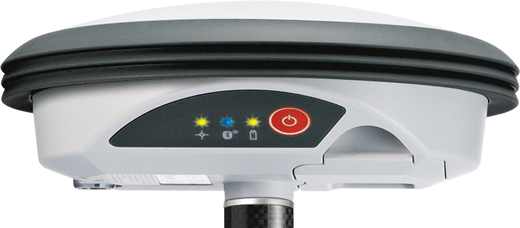
With its recent Ingress Protection (IP) certification, the Leica Zeno GG03 SmartAntenna is now an IP68-certified SmartAntenna for GIS applications. IP68 represents the top rating for protection against dust, moisture and water. Meeting the tough standards for Ingress Protection (IP) makes the Leica Zeno GG03 a rugged GNSS SmartAntenna for GIS asset collection and management tasks.
The upgradable Leica Zeno GG03 SmartAntenna is designed for organizations that require a compact and lightweight device for accurate and reliable positioning. The robust design of the Zeno GG03 brings further advantages when collecting GIS assets by offering reliable and rugged operation in extreme environments, even after continued exposure to water and dust.
“The Leica Zeno GIS series is used all over the world in the most demanding environments,” said Product Manager Johannes Hotz. “The IP68 rating further underlines the quality and robustness of the Leica Zeno GG03. The industry-leading GNSS performance and an unmatched ultra-rugged design is a big win for our customers in the field.”
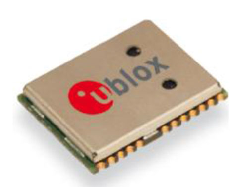
The NEO-7P sub-meter GPS positioning module with Precise Point Positioning (PPP) and Differential GPS.
Swiss-based u‑blox has introduced the NEO-7P, an improved, low-power, compact, high-precision GPS module. While remaining backwards compatible with its predecessor NEO-6P, the new module achieves standalone sub-meter precision based on single-frequency precise point positioning (PPP) technology.
Fully autonomous sub-meter performance can be realized for most outdoor applications within coverage of Satellite Based Augmentation Systems (SBAS) throughout North America (WAAS), Europe (EGNOS), and Japan (MSAS).
In areas where SBAS is unavailable, the NEO-7P achieves high-accuracy based on Differential GPS (DGPS) positioning as an alternative to PPP. DGPS uses RTCM correction messages (correctional data defined by the Radio Technical Commission for Maritime Services) from a local reference station or aiding network to cancel out measurement error introduced by atmospheric distortion and variances in satellite orbits and clocks.
“The NEO-7P addresses many requirements for precise positioning used in surveying, mapping, marine, and clear-sky recreational applications,” said Thomas Nigg, VP product marketing at u-blox. “The solution delivers sub-meter positioning performance based on two techniques at a fraction of the cost of other high precision solutions. The solution is compact, requires no external base station, and uses a single frequency receiver.”
The device comes in u-blox’ compact NEO Leadless Chip Carrier (LCC) module form factor. A UART, USB and I2C interface provide flexible connections to a host processor. It can also communicate directly with u‑blox’ SARA 2G, LISA 3G and TOBY LTE cellular modules.
The NEO-7P also provides complete GPS satellite raw data allowing further accuracy improvement based on post processing by an external host. Internal Flash memory allows simple firmware upgrades. The NEO-7P also supports Russian GLONASS Japanese QZSS positioning standards.
The module is suitable for vehicle, industrial and consumer applications.
Detailed information about the NEO-7P can be found on the u-blox website.
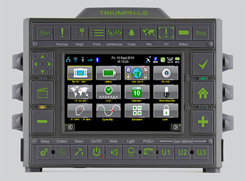
JAVAD GNSS has launched a new version of the TRIUMPH GNSS receiver, which features 864 channels — more than any receiver it has yet offered. The TRIUMPH-LS land survey receiver offers, in addition to the 864 GNSS channels, three powerful processors, 256 I/O, 24 digital filters, 24 anti-jam filters and 14-MB program memory all in a single chip, which uses less power and makes the total system less expensive, according to the company.
The announcement was made at the ION GNSS+ Conference, being held this week in Nashville, Tennessee.
Javad Ashjaee, CEO and founder, explained the decision to incorporate 864 channels. “Some questioned the need for the 216 channels. They now realize the need for 440 channels. We assign multiple channels to each satellite for redundancy and reliability. We use more than 100 channels to scan GNSS bands for interference — 864 channels is the key to reliable performance.”
The TRIUMPH-LS provides visual stake-out, six parallel RTK engines, more than 3,000 coordinate conversions, advanced coordinate geometry features, and rich attribute tagging on a high-resolution 800 x 480 pixel display. When used in photogrammetry, offsets can be calculated using the internal camera for 10-centimeter accuracy, or an external camera for 5-centimenter accuracy. TRIUMPH-LS is the first JAVAD GNSS receiver to offer photogrammetry for land survey.
Other features include versatile attribute tagging, feature coding, automatic photo and voice documentation, and an interference monitoring and reporting feature.
The TRIUMPH-LS has a battery life of 25 hours in RTK rover mode with full screen brightness and UHF/GSM. Two hours of charge equals two days of surveying. The internal batteries are field serviceable and can be easily replaced by the user when needed.
The TRIUMPH-LS, including batteries and pole, is the lightest GNSS RTK receiver in its class, according to JAVAD GNSS. The total weight of the system — including radio, controller, pole and 25 hours of internal battery — is 2.5 kilograms.
Built on a tough magnesium alloy chassis, all connectors, SIM cards, and micro-SD cards are protected against harsh environmental conditions. The pole can be collapsed and the unit can easily fit in a car seat — there are no long poles and no separate controller or brackets to disassemble.
The TRIUMPH-LS automatically updates all firmware when connected to the Internet via Wi-Fi. The built-in GNSS full tracking antenna has a large ground place and excellent centering and rotational performance.
To learn more about the TRIUMPH-LS, stop by the JAVAD GNSS booth (Booth D) in the ION GNSS+ Exhibit Hall now through Friday.Presentation will be given Thursday at the conference room of the exhibition hall at 2:00 pm.
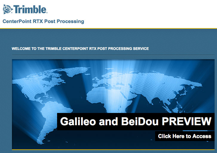
The preview version of Trimble’s CenterPoint RTX post-processing service, enabling GNSS observations using available Galileo and BeiDou MEO satellites.
Trimble announced today a Preview version of its CenterPoint RTX post-processing service, enabling GNSS observations using available Galileo and BeiDou Middle Earth Orbit (MEO) satellites. Powered by Trimble RTX technology, the free CenterPoint RTX post-processing service provides better than centimeter level positions.
The announcement was made today at ION GNSS 2013 Conference and Exhibition.
The existing CenterPoint RTX post-processing site uses data from the GPS, GLONASS, and QZSS satellite systems. Through a link accessible from the post-processing website, users can enter a Preview site and derive positions that also use data from available open service Galileo and BeiDou MEO satellites.
“With the addition of Galileo and BeiDou MEO support, we offer researchers, scientists and academics the opportunity to evaluate and experiment with results from these evolving satellite constellations,” said Patricia Boothe, general manager of Trimble’s Positioning Services Division. “We are committed to continuing to advance CenterPoint RTX post-processing and the underlying Trimble RTX technology to enable ever higher accuracy positioning solutions.”
Trimble CenterPoint RTX post-processing is a cloud-based service accessed through www.TrimbleRTX.com. Users around the globe can upload static GNSS observation data and receive positioning corrections calculated in the well-defined International Terrestrial Reference System (ITRF) 2008 reference frame. The post-processed solution can be transformed to a variety of regional reference frames by selecting a coordinate system and tectonic plate.
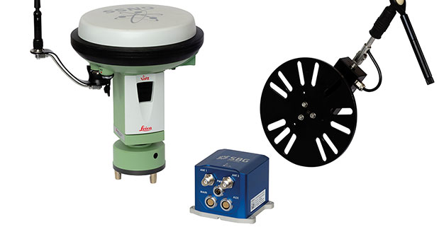
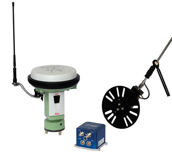
At ION GNSS+ this week, SBG Systems announced the release of the Ekinox Land Solution, an all-in-one solution combining the cost-effective inertial navigation system with an odometer, and a GNSS RTK reference station for smooth positioning in land applications. GPS positioning in urban canyons, forests, or tunnels has always been challenging. By taking the best of these complementary technologies, Ekinox Land Solution provides reliable positioning in an affordable package, the company said.
SBG Systems is exhibiting the system Wednesday through Friday at Booth 519/521 at ION GNSS+ in the Nashville Convention Center.
The combination of the Ekinox inertial navigation system with complementary technologies such as wheel-speed sensor (DMI) and RTK GNSS is the key to providing smooth vehicle positioning, even during GPS outages, SBG Systems said. To save users and integrators both time and money, the best equipment has been tested and selected to build a cost-effective and all-in-one package — Ekinox Land Solution.
Ekinox Land Solution is an integrated package built from the Ekinox Series, a range of inertial navigation systems based on robust and cost-effective MEMS technology. Mounted on a vehicle, Ekinox Land Solution provides real-time roll, pitch, and true heading (0.05° accuracy) while delivering a smooth position (2 cm). Data is output at 200 Hz and recorded in an 8-GB datalogger. Post-processing software is offered to increase attitude accuracy (up to 0.02°).
Ekinox Land Solution is designed to answer the growing need of vehicle real-time positioning, imagery sensor triggering, and data georeferencing at an affordable price. Examples of applications include mobile mapping, machine control, car motion analysis, and unmanned ground vehicle navigation.
The Ekinox series includes the Ekinox-A, and Attitude and Heading Reference System; the Ekinox-E, an Inertial Navigation System (INS) whose position feature depends on aiding equipment; the Ekinox-N, an INS with an embedded L1/L2 GNSS receiver; and the Ekinox-D, an INS with an integrated Dual Antenna GNSS receiver.
SBG Systems is a French supplier of MEMS-based inertial motion sensing solutions. The company provides a wide range of inertial solutions from miniature to high accuracy. Combined with calibration techniques and advanced embedded algorithms, SBG Systems products are designed for defense, industrial and research projects, such as unmanned vehicle control, antenna tracking, camera stabilization, and surveying applications.
Handheld Group has announced the launch of the new version of its popular Algiz 7 rugged tablet computer. The updated Algiz 7 is considerably faster than its predecessor, with better storage capacity, improved security and quicker communication capabilities.
According to the announcement, the ultra-rugged Algiz 7 tablet PC is small, light and fast, with multiple connectivity options and a wide range of functions, ideal for field workers demanding a super-durable product that is tough and powerful, yet light and easy to work with. The Algiz 7 meets stringent MIL-STD-810G military standards for withstanding humidity, vibrations, drops and extreme temperatures, and with its IP65 rating it keeps dust and water out as well.
The new Algiz 7, which started shipping this week, features the following improvements from earlier versions:
A fast and powerful N2600 1.6 GHz Dual-Core Intel ATOM processor.
More memory, with 4 GB of DDR3 RAM.
Better storage, with a 128GB SSD SATA II with recovery partition.
Two full mPCIe slots for improved flexibility.
Ethernet 10/100/1000 (Gigabit).
Added data security with TPM chipset board (chip 1.2).
An updated version of the wireless Gobi 3000 technology for higher communications speed.
A 5-megapixel camera.
Antenna diversity (two antennas) for improved coverage.
“We’ve made significant improvements to the new Algiz 7,” said Jerker Hellström, CEO of Handheld Group. “Better storage, a much faster processor, improved security, a better camera and better communications are some enhancements – and we’ve kept the price point the same as for the previous version of the Algiz 7. This product should remain the tablet of choice for anyone looking for portable, professional field performance.”
The Algiz 7 weighs 1.1 kilograms and has a 7-inch widescreen touch display that features the new and unique MaxView technology, providing brightness in outdoor conditions — even direct sunlight. It runs the state-of-the-art Microsoft Windows 7 Ultimate operating system. GPS navigation functionality is fully built in.
The Algiz 7 is specifically developed for use in tough environments in industries such as mining, geomatics, logistics, forestry, public transportation, construction, utilities, maintenance, military and security.
CHC today announced the availability of the LT400HS, a rugged 120-channel GPS+GLONASS handheld receiver designed to achieve sub-meter SBAS positioning to centimeter accuracy in RTK networks. The LT400HS is designed to be a cost-effective yet powerful GNSS device for survey, construction and GIS professionals.
The LT400HS is designed for companies that have not yet invested in GNSS technology due to cost or occasional equipment use, such as earth-moving and landscape contractors, real estate developers, construction SMEs, agriculture irrigation companies, and utilities mapping companies.
“The LT400HS GNSS handheld series is a compact, rugged, accurate and easy-to-use GNSS receiver to perform surveying and precision mapping tasks wherever RTK Network corrections are available,” said George Zhao, CEO of CHC. “The LT400HS offers unrivaled performance, an attractive price point filling the price performance gap that exists in the industry between GIS level collectors and professional RTK rovers such as our recently introduced X+ GNSS Series. ”
The LT400HS Series features:
Professional 120-channel GNSS Engine – L1/L2 GPS + GLONASS supporting RTCM network RTK corrections and industry standard NMEA output.
Built-in GSM/GPRS phone with data transmission, Bluetooth and Wi-Fi connectivity.
Built-in 5 megapixel autofocus camera to capture assets information.
It comes bundled with Carlson’s SurvCE software for survey and construction professionals, or DigiTerra Explorer Mobile GIS software for accurate GIS field data collection and maintenance.
Juniper Systems has released a new version of its field mapping software, Juniper Aspect 1.2. The release builds upon and adds to its previous strengths as an easy-to-use, versatile mapping tool.
Juniper Aspect is a field mapping software designed to boost efficiency and productivity, while being simple enough that anyone can quickly learn how to use it, according to Juniper. It places the capabilities of GPS and GIS in the hands of field workers, resulting in more streamlined processes, the company said. Used for any job that requires locating, documenting, and inspecting assets, Juniper Aspect is a flexible solution for many different lines of work.
Juniper Aspect version 1.2 offers improvements designed to boost worker efficiency and user-friendliness. With a new feature to more extensively filter and organize data, and an ability to more easily import large amounts of data into Excel, Juniper Aspect 1.2 offers greater benefits in time-savings and ease of use, the company said. Furthermore, the software appeals to a broad audience, as it will now operate on most devices running Windows Mobile 6.0 or higher.
“At Juniper Systems, our focus is on the customer,” said Jim Benson, Public Works Market Manager at Juniper Systems. “And that’s why we have implemented many of the new changes in Juniper Aspect 1.2—to respond to the requests of our users. This new release is amazingly easy to use, and yet it does more to make jobs easier and workflows run smoother.”
Current Juniper Aspect customers will automatically receive the new upgrade simply by checking for new updates in their current software version. New customers can contact Juniper Systems to learn more about Juniper Aspect 1.2. They can also download a free preview version of Juniper Aspect.
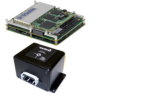
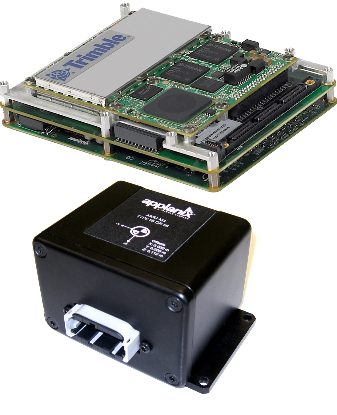
Trimble introduced today the Trimble AP15, the latest member of the AP series of OEM GNSS-Inertial board sets. The introduction was made at the AUVSI 2013 Conference and Exhibition, being held in Washington, D.C.
The AP15 uses a custom Micro Electromechanical Machined (MEMS) based Inertial Measurement Unit (IMU). It is the first product to take advantage of Applanix’ proprietary calibration process — Applanix SmartCal, a new software compensation technology that allows Trimble to achieve exceptional performance from IMUs manufactured specifically for mobile mapping applications.
The AP15 combines high-precision GNSS positioning with Applanix IN-Fusion GNSS-Inertial integration technology, all running on a powerful, dedicated Inertial Engine (IE) board. AP products provide the performance and functionality of Applanix’ POS systems in an embedded form-factor that is specifically designed for third-party manufacturers and systems integrators, Trimble said. The AP Series is designed for a variety of commercial mobile positioning and orientation applications including airborne, terrestrial and marine mapping and guidance for unmanned vehicles.
Combined with a wheel-mounted Distance Measurement Instrument (DMI), the AP15 provides a full 6-degrees-of-freedom navigation solution for land vehicles that is capable of providing robust position and orientation information regardless of obstructions to GNSS-only positioning such as multipath or complete signal loss. Applanix IN-Fusion technology produces uninterrupted position, roll, pitch and true heading measurements of moving platforms by combining IMU data with raw GNSS observables and DMI velocity.
GNSS functionality is provided by a Trimble GNSS module, a dual-antenna, 440 channel, multi-frequency survey-grade GNSS receiver that supports a wide range of satellite signals, including GPS L1/L2/L2C/L5 and GLONASS L1/L2 signals. The module also supports Satellite-Based Augmentation Service (SBAS) corrections, including the U.S. Wide Area Augmentation System (WAAS), European Geostationary Overlay Service (EGNOS), Japan’s Multi-functional Satellite Augmentation System (MSAS) and the OmniStar VBS, HP and XP/G2 corrections.
“Trimble is a leading provider of technology for positioning and orientation solutions and the introduction of the AP15 module continue this tradition,” said Kevin Andrews, product manager. “The AP15 has been designed as a more compact, lighter unit which can deliver excellent performance at lower cost.”
The Trimble AP15 is expected to be available in October of 2013 through Applanix’ sales channel.
Topcon Positioning Group announces new reference station network software — TopNET+ v10 — bringing new features and functionality to the TopNET+ reference station software suite.
Topcon’s TopNET+ software is a scalable solution supporting everything from a single CORS station to multiple CORS sites covering a large geographical area. Users of a TopNET+ reference network get GNSS RTK correction data generated using information from all reference stations in a network. This feature allows regional use of RTK while providing data that is specific for each local rover, Topcon said.
New features available in the latest TopNET+ v10 include:
Custom sub-networks based on a rover’s position within a larger regional network, which better supports the network RTK rover to local field conditions;
RINEX (Receiver Independent Exchange Format) shop with expanded data management functionality for conversion of data from Topcon and third party reference stations connected to the network;
Background maps and BING Maps allow multiple perspectives of the network orientation and regional surroundings;
“This upgrade of TopNET+ software provides increased capabilities and a more visual and detailed presentation of network status to the users of Topcon networks,” said Tom Morris, TPS senior product development manager. “Users will have a customized solution better adapted to local conditions and a better view into the hard processing and statistics being generated in TopNET+.”
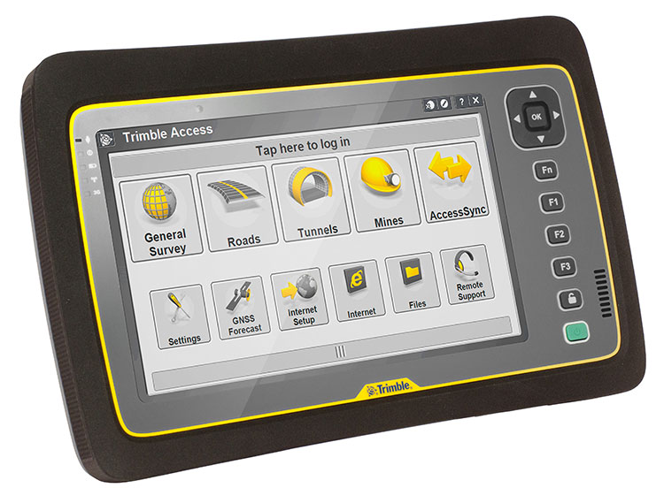
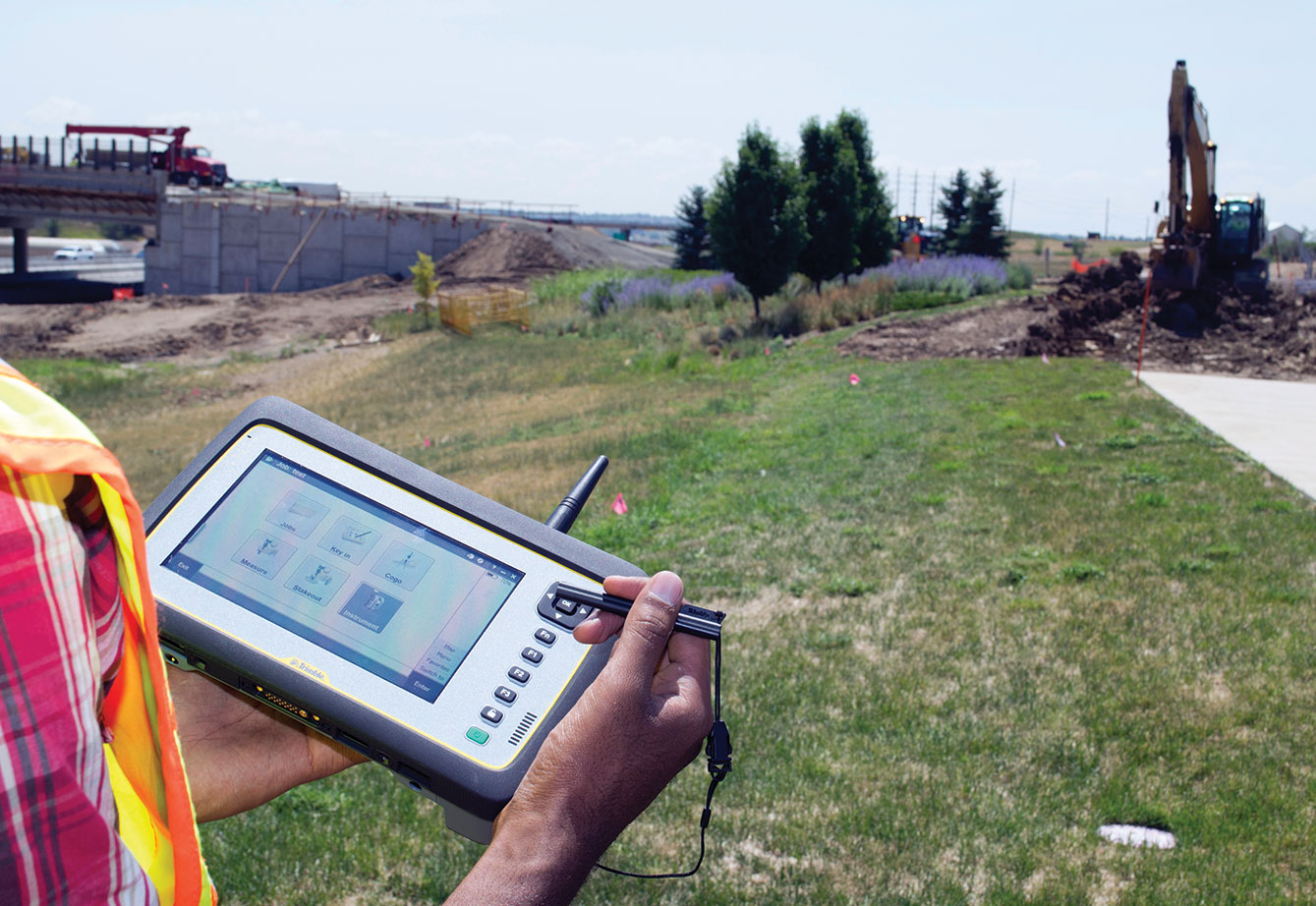
Trimble introduced today its next-generation Trimble Tablet PC for surveying. The Trimble Tablet is a lightweight, rugged and highly mobile field computer that can operate with Trimble’s suite of receivers and total stations to provide a complete surveying solution. With Trimble Access field software onboard, the Trimble Tablet streamlines the flow of information between the field and office while also allowing surveyors to run the applications they need to perform office work directly from the field.
The Trimble Tablet offers a 7-inch capacitive multi-touch screen in an easy-to-hold form factor that measures 6.3 inches x 9.6 inches and weighs three pounds. An extended battery set provides up to 16 hours of operation.
With the Microsoft Windows 7 Professional operating system, a 1.6 GHz Intel Atom dual-core processor, 4 GB RAM and 128 GB of flash-based storage onboard, the Trimble Tablet allows surveyors to run a variety of the applications they need to perform office work fast and reliably. Connectivity via Bluetooth, Wi-Fi and a built-in 3.75G GSM cellular data modem enables manageable and efficient workflows so surveyors can remain connected wherever networks are available. With the Trimble Tablet, surveyors can check their work and deliver it to clients without a trip back to the office.
Using the multi-touch capacitive touchscreen, surveyors can type, pan, and zoom with their fingers, a stylus or capacitive gloves. The large display features new technology created specifically to enhance sunlight readability. Viewing data, maps and applications is also easier so that surveyors can unlock the full potential of Trimble VISION instruments and applications dependent on highly visual data and graphic interfaces. Jobsite documentation is possible using the Trimble Tablet’s built-in 5MP camera with autofocus and built-in flash capabilities, while simultaneously providing geotag functionality using integrated GPS.
Ruggedized for extreme conditions, the Trimble Tablet holds an environmental rating of IP65 and can operate in temperatures of –30 °C to +60 °C (–22 °F to +140 °F), providing exceptional versatility, efficiency and portability. The full-color screen resides under a Gorilla Glass panel that is scratch and impact resistant.
“The ability to stay connected and complete office work from the field is becoming increasingly important to surveyors,” said Elmar Lenz, business area director of Trimble’s GNSS and survey handheld solutions. “With new features and functionality, the next generation Trimble Tablet rugged PC is an ideal solution that provides even more capability to surveyors—more memory, computing power, connectivity, data visualization, increased documentation and more.”
The Trimble Tablet rugged PC is available for ordering immediately through Trimble’s Survey distribution channel.
Flowfinity Wireless, Inc., a provider of enterprise mobile applications, has announced a solution that enables businesses to quickly create and deploy mobile surveys for offline data collection and submission to a centralized database. Flowfinity’s survey customization and integration features help businesses improve productivity through better management of information collected in the field, the company said.
Survey data can be captured anywhere, even in locations without network coverage such as job sites, retail store stock rooms, or manufacturing plants. Feedback submitted in real time to a Flowfinity database provides actionable insights that allow businesses to improve efficiency and identify issues that require immediate attention, the company said. Information stored in the database such as survey results, locations, or customer data can also be easily retrieved on mobile devices.
Flowfinity mobile surveys configured using a point-and-click web-based editor can include dynamic fields such as checklists, drop-down menus, photos, signature capture, and GPS locations. Conditional field visibility allows users to be guided through the survey form based on previous answers. As soon as surveys are created, they can be immediately published to different user groups based on user permissions.
“Flowfinity helps businesses collect and access the information they need in the field, so that they can eliminate inefficient paper and spreadsheet processes,” says Larry Wilson, VP of Sales and Marketing, Flowfinity. “While many mobile survey solutions offer simple one-way data submission, Flowfinity provides two-way access to survey data from a centralized database, allowing feedback to be viewed or submitted anytime, anywhere.”
Flowfinity mobile survey software is available as a fully cloud-hosted or on-premise deployed solution.
 With its recent Ingress Protection (IP) certification, the Leica Zeno GG03 SmartAntenna is now an IP68-certified SmartAntenna for GIS applications. IP68 represents the top rating for protection against dust, moisture and water. Meeting the tough standards for Ingress Protection (IP) makes the Leica Zeno GG03 a rugged GNSS SmartAntenna for GIS asset collection and management tasks.