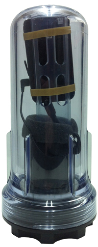
Geneq Inc. has announced the SXBlue II GNSS, a GNSS receiver that uses both GPS and GLONASS with SBAS (WAAS/EGNOS/MSAS/GAGAN) to attain 30-cm/1-foot (RMS) accuracy in real-time using free SBAS corrections. It connects wirelessly to any smartphone, handheld, tablet computer, or notebook computer that is Bluetooth-compliant.
For years, the SXBlue GPS product line has lead the market in squeezing the most out of SBAS for high-precision mapping and surveying users. New technology used in the SXBlue II GNSS allows it to utilize both GPS and GLONASS with SBAS, enabling it to track and use nearly twice as many satellites compared to typical SBAS receiver technology.
“More satellites means more accurate positioning in tougher environments, such as under tree canopy and near buildings,” said Jean-Yves Lauture, product engineer. “GLONASS has proven itself valuable for RTK, and now we are bringing GLONASS to SBAS, with impressive accuracy and tracking results.”
The SXBlue II GNSS builds on the success of the proven SXBlue II GPS that was designed to optimize SBAS performance under tree canopy and in rugged terrain. With the ability to track 55 satellites (31 operational GPS, 24 operational GLONASS), the SXBlue II GNSS uses between 12 and 19 satellites in view at any time, providing superior performance when working under and around tree canopy, buildings, and rugged terrain, Geneq said.
The next-generation SXBlue II GNSS is the same, small, palm-sized unit as the SXBlue II GPS and uses a small 2.7-inch diameter GNSS antenna. The unit is completely waterproof (submersible), dustproof, and ruggedized, with an IP-67 rating. Its Class 1 long-range Bluetooth 2.0 has a typical range of 250 meters. The internal, rechargeable, field replaceable Li-Ion battery has on-board LEDs let the user know how much battery life is left. The operating temperature range of the SXBlue II GNSS is -40°C (-40°F) to 85°C (185°F).
In addition to the built-in long-range Bluetooth transceiver, the SXBlue II GNSS has a standard DE-9 RS-232 port and a USB Type B port with outputs fully programmable up to 10-Hz standard, with a 20-Hz option. Other optional features are L1 RTK for <2-cm real-time accuracy and base station RTCM output.
There is no need for post-processing or other sources of differential corrections as the SXBlue II GNSS uses WAAS (North America), EGNOS (Europe), MSAS (Japan), and GAGAN (India) satellite corrections. Users receive real-time, 30-cm/1-foot positioning all day long, Geneq said.
The SXBlue II GNSS is targeted at GPS/GIS mapping professionals in industries such as forestry, utility, agriculture, and other natural resource industries in addition to local, state, and federal government users.
Geneq will be showing the SXBlue II GNSS at the Esri International User Conference July 24-26 in San Diego, California, booth #1203.
This discussion of current trends in location-enabled mobile devices takes as its foundation the different operating systems (OSs) for those devices. Why? For GPS/GNSS hardware units to be useful, there have to be software applications — apps — also riding on those units. Apps are totally dependent on the operating system. An analogy is that the operating system is the foundation of a house and the app is the house itself. The type of foundation you have drives what type of house you can build.
For example, no one is going to write an app today for Palm OS because that OS is essentially dead. While that’s an obvious one, a not-so-obvious one is Microsoft Windows Mobile. Most apps written for professional users are written in Windows Mobile, but Microsoft hasn’t done a good job of communicating its intentions regarding Windows Mobile, so users and developers think Microsoft may abandon it.
On the other hand, Android is gaining so much momentum. Will developers rewrite their apps from Windows Mobile for Android? Or for Apple’s iOS? Can they afford to? Can they afford not to? If they don’t, that would mean that fewer professional apps will be available for Android and iOS users. Will that mean Windows Mobile will be the OS for professional GPS/GNSS users, and conversely, will Android/iOS be the OS for consumer-level GPS/GNSS users? Taking it to a practical conclusion, according to the type of mobile computing device that you purchase, what kind of location application will you be able to use?
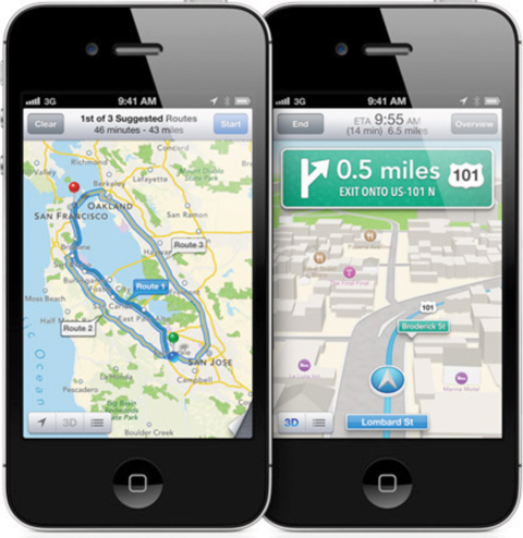
Smartphones. Apple iOS’s new Maps app will likely be the largest scale crowd-sourced app ever introduced.
PNDs Out-Smarted
For the past decade, GPS personal navigation device (PND) sales have burned white-hot. In 2007, Garmin experienced double- and triple-digit growth, selling more than 10 million units. TomTom grew from zero to hero and sold more than 9.5 million units in that same year. During that brief golden era, every consumer electronics company who was anyone took a stab at introducing a PND to get a piece of the action. As unlikely as it seems, Garmin and TomTom stayed on top, fighting off consumer electronic giants like Sony, Panasonic, Hewlett-Packard, and Philips, all orders of magnitude larger. PNDs ruled the GPS world during that era.
Download a PDF of our Mobile Computing Product Showcase.
At the height of that period of explosive GPS PND growth, Apple introduced a new generation of smartphone, the iPhone, in January 2007. At that time, there were approximately 17 million smartphones on the market. Nokia with its Symbian operating system led the pack at 63 percent of worldwide market share, Blackberry was the rising smartphone of choice, while Microsoft Windows Mobile operating system captured 18 percent. Google’s Android operating system had not yet debuted.
It’s amazing how a mass-market technology, so personal to us all, can change so quickly. Today, Google’s Android operating system dominates the smartphone market (roughly144.4 million smartphones were sold in Q1 alone of 2012, according to Gartner Research) with a 56.1 percent share. Apple’s iOS follows at 22.9 percent; Symbian (Nokia) has fallen from leader to bit player at 8.6 percent, and keeps company in the low rungs with RIM/BlackBerry (6.9 percent), Samsung’s Bada (2.7 percent), and Microsoft Windows (1.9 percent).
The trend is clear. Android and iOS are cleaning up at the expense of all the others. Is it any coincidence that these two are the ones making the most of their maps and nav? More on this in a moment.
By the way: every one of the 144.4 million smartphones that shipped in the first three months of 2012, no matter what operating system it ran on, carried a GPS receiver inside, typically a chipset from Broadcom, CSR/SiRF, u-blox, Qualcomm, or Texas Instruments. That spells trouble for Garmin and TomTom. Google and Apple are doing to Garmin and TomTom what Microsoft did to NetScape with Internet Explorer.
Even with GPS PND prices at an all-time low, Google’s Navigator, with high-quality, PND-like turn-by-turn street navigation, is included on Android smartphones free of charge. Apple is following suit. Just last month, Apple introduced the Maps app for turn-by-turn street navigating as well as real-time traffic information. With more than 100 million iPhones behaving like traffic sensors, Apple’s Maps app will likely be the largest scale crowd-sourced app ever introduced.
What does this mean to Garmin and TomTom? The numbers don’t lie. In February 2012, TomTom reported a 40 percent decrease in GPS PND sales for Q4 2011 compared to Q4 2010.
Tablet Computers
For another wild ride, take a look at the tablet-computer market. The tablet has been around for many years. I remember playing with them in the 1990s when they were horribly expensive ($3,000–$5,000). The price, a limited outdoor-viewable display, and power usage all combined to squash unit sales. Only a few manufacturers such as Fujitsu had the determination to stay. That all changed in 2010 when Apple introduced the iPad.
Prior to the iPad rollout, tablet computer sales were limited primarily to business users. Healthcare provided a particular arena for Fujitsu and others to focus on, and there were a few other markets that were not very price-sensitive, and so receptive to the tablet. The iPad blew away that $3–5K price point (iPad 2, $629) and brought the tablet experience to the average consumer. The result? Roughly 67 million units sold since its introduction, far surpassing all tablet computer unit sales in history in just two years. Apple hit a sweet spot, for sure.
The iPad catalyzed the tablet industry for two reasons:
It opened the eyes of the consumer to the applications of a tablet computer.
It drove the price-point expectation of all tablets down.
Of course, the iPad has its limitations. It runs Apple’s proprietary operating system, iOS, so you are limited to the number of apps written for that platform. It also lacks horsepower to run more challenging programs that an Intel or AMD-based computer can breeze through. From a GPS/GNSS perspective, certain models of the iPad sport a GNSS chipset (from Broadcom) similar to mobile phones; however, because of the way the GPS functionality is designed into the system, accuracy is limited to a few meters at best. Power GPS/GNSS users would love it if Apple would implement serial port profile (SPP) in its Bluetooth software. Then, GPS/GNSS users could attach any Bluetooth-compliant GPS/GNSS receiver they like, even RTK-capable receivers for centimeter-level accuracy. But Apple doesn’t seem interested.
As in the mobile-phone market, Google is making a strong tablet play with its Android operating system. Google’s device-agnostic operating system is attracting tablet hardware makers in droves with iPad-like tablet computers, notably Samsung Galaxy (with GPS) and Amazon Kindle Fire (no GPS). Also, there’s an interesting link between mobile phones and tablets. Gartner reports that 40 percent of user apps run on both mobile phones and a corresponding tablet computer. This is significant because the operating system may well drive the tablet purchase. For example, a person with an iPhone is more likely to buy an iPad than a Samsung Galaxy, which runs Google Android.
However, Android has not achieved the dominance in the tablet computer space that it has in smartphones. iOS (iPad) held 67 percent market share in 2011, falling to 61 percent in 2012,but still retaining the pole position. Android is a strong second with 29 percent in 2011, rising to 32 percent in 2012, according to Gartner. No other operating system even comes close.
Gartner forecasts show that Android will eventually approach iOS in market share, and my guess is that it will overtake iOS within five years. Apple’s proprietary system will catch up to it. While GPS/GNSS chipsets aren’t as widely integrated in tablets as they are in mobile phones, that will change as GPS/GNSS use becomes even more ubiquitous. Further, there are plenty of ways to add GPS to a non-GPS model via Bluetooth, PCMCIA, and USB.
Android supports Bluetooth SPP, or a derivation of it, so you can connect any Bluetooth SPP-compliant GPS receiver that you like and not be limited to the receiver chipset the tablet engineer decided to design into the system.
]Although PDAs have an embedded receiver, they are lower-precision systems, in the 1- to 5-meter range, largely due to poor antennas. For higher precision requirements, these are used as field data collectors connected to an external antenna and/or a high-precision GPS/GNSS receiver.Handheld PDAs
Handheld personal digital assistants (PDAs) were all the rage 10 years ago when Compaq Computer Corp. introduced the iPAQ H3100 running Microsoft’s PPC2000 (Pocket PC) operating system, the precursor to Microsoft’s Windows Mobile operating system. The iPAQ made a strong run through 2009, with the last models running Windows Mobile 6 before smartphones became powerful enough to negate the purpose of the PDA.
While we probably will never see another introduction of a new iPAQ-branded PDA, it was a useful device and an inexpensive handheld for interfacing to GPS/GNSS receivers. Albeit a niche market, there’s still a demand for such handhelds for field data collection.
According to the nature of capitalism, where there’s a demand, suppliers will show up. Since the iPAQ has faded, and smartphones aren’t yet well-suited as field data-collection devices, a new breed of semi-rugged and rugged PDAs has emerged in the past year from small, niche-oriented companies. Examples include the SXPad from Geneq, Juno 3 series from Trimble, and the Mesa/Rampage 6 from Juniper Systems/SDG Systems.
These devices, with GPS/GNSS receivers embedded, are not built for the average consumer. Their prices are higher — but coming down — and they are more rugged; some are water-resistant, some waterproof.
In a nutshell, PDAs went professional, targeting organizations that need maximum data-collection productivity from field personnel. Although they have an embedded receiver, they are lower-precision systems, in the 1- to 5-meter range, largely due to poor antennas. For higher precision requirements, these are used as field data collectors connected via Bluetooth to a high-precision GPS/GNSS receiver.
Although the professional PDA market is not immune to the operating-system wars we’ve seen in mobile phones and tablet computers, it’s a bit stickier. Professional data-collection apps have been written almost exclusively around the Microsoft Windows Mobile operating system. These niche software programs are written for relatively small audiences (compared to the mass-market apps on smartphones), and it can be economically tough to justify porting the apps to iOS or Android. Therefore, the professional PDA market has been slower in adopting iOS and Android.
Microsoft hasn’t helped the cause. It stopped certifying new products with the Windows Mobile operating system, creating confusion in the user community. Is Microsoft exiting the mobile device business? Not according to the company. It appears that it has split the mobile device business into two operating systems. Smartphones will run Windows Phone, and other mobile devices will run Windows Embedded Handheld, which is compatible with Windows Mobile.
The problem, the confusion, and the frustration come from the fact that the Windows Phone operating system is not compatible with Windows Mobile (or Windows Embedded Handheld). Microsoft split the market between smartphones and other Microsoft-driven mobile devices. Given Gartner’s research that 40 percent of users’ smartphone apps also run on a tablet device, this means that Microsoft is going to either change that dynamic or suffer the consequences.
No matter which direction mobile devices take, be it phone, handheld, or tablets running Android, iOS, Windows, or something we haven’t yet seen, embedded GPS/GNSS functionality will remain the centerpiece of location technology in all mobile devices. Even more exciting are the new GNSS signals and constellations in the next five years that will bring unprecedented accuracy to all mobile devices, driving the development of a tremendous number of new apps to exploit the improving accuracy.
Eric Gakstatter is contributing editor for survey at GPS World magazine and the editor of Geospatial Solutions. He has spent the past 20 years in the GPS survey/mapping industry, using many brands of GPS equipment and software. He is a non-partisan advocate for the GPS user community, and a frequent speaker at user and technical conferences.
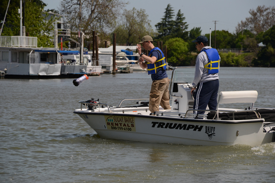
UC Berkeley researchers have developed a method to provide real-time, high-resolution data in hard-to-map waterways, using GPS. Tossing a robot is Andrew Tinka, with Kevin Weekly. (Photo courtesy of Jérôme Thai.)
By Tracy Cozzens
A fleet of 100 robots equipped with GPS and sensors were released May 9 into California rivers to measure water flow, salinty levels, and pollution. The Floating Sensor Network is a project by the University of California, Berkeley, to improve the way water quality and flows are monitored.
About two-thirds of California’s fresh water is in the Sacramento-San Joaquin river system where the test took place. This water supplies about two-thirds of the state’s population with drinking water and irrigation. The initiative is led by associate professor Alexandre Bayen at the Center for Informatin Technology Research in the Interest of Society (CITRIS).
The robots each have a sensor to test salinity and a GPS unit from a smartphone. Some have propellers so they can maneuver around obstacles and reach specific destinations. The robots also sent Tweets to @fsnandroid61.
The robots drifted through the area of the river being measured, then were retrieved by boat. “One advantage of our real-time communication system is that we can see where all our sensors are on a map, which makes it very easy to chase them down and retrieve them,” said graduate student researcher Andrew Tinka.
With the first test completed, the team’s efforts over the summer have two priorities, Tinka explained. “First, we’re using the flow data that we gathered on May 9 to understand how this ‘mobile’ data can be best used for river hydrodynamics studies. We’re learning how to turn the individual traces of water that each sensor gives us into a big-picture view of the entire river region, sort of how like meteorologists take the data from a few weather stations and turn it into an overall view of what the weather is doing over a large area. Second, we’re working with other hydrodynamics research groups to expand the use of this kind of mobile sensor. We’re loaning our equipment to other groups, doing pilot projects with others, and basically trying to get these sensors into researchers’ toolboxes throughout the water community.”
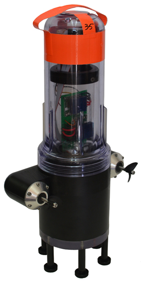
There are two types of devices in the fleet, active and passive. The active sensors have a twin-propeller drive system that lets them move through the water to avoid obstacles or stay in the correct region of the river. “We developed the internal electronics for this device ourselves,” Tinka said. “We integrated a Magellan AC12 GPS receiver along with a Gumstix embedded computer and a Motorola GSM module. Our passive sensors don’t have a propulsion system; they do exactly what the water does. We developed this system with a focus on cost and ease of assembly.” The team used a waterproof consumer smartphone, the Motorola Defy, for the GPS positioning, computation, and comunications.
So far, the test has proven the usefulness of such a network. The devices were developed to be easily deployable, especially where a lot of flexibility is needed, such as in disaster response. “The ability to quickly and easily put these sensors into new inland environments, by just about any method (throw them from a boat, drop them from a helicopter, toss them from a dock or a bridge) makes them a really useful new tool,” Tinka said.
photos courtesy of Jonathan Beardphotos courtesy of Jonathan Beard
A hundred robots, 40 with propellers, were released into the Sacramento River near Walnut Grove (photos courtesy of Jonathan Beard).
Esri announced the release of ArcGIS for Windows Mobile 3.0 and its availability for download from the Esri Customer Care site.
According to the announcement, with a new name and a new version number, ArcGIS for Windows Mobile 3.0 includes significant enhancements and improvements to the user experience, architecture and deployment of mobile solutions.
Here are a just a few highlights of 3.0:
Creating and Managing Field Projects
Simplified Project Management – with the 3.0 release you can include mobile caches, basemaps and project extensions inside the mobile projects you create. So all you need to do is pull or push the project to your device and it will unpack and manage the offline data content as well as any and all extensions.
Project and Service Validation – the Mobile Project Center includes a validation framework that will ensure the integrity of your field projects by detecting, notifying and recommending changes before you publish out to your field workers.
Qualify Map Layers for Synchronization – 3.0 simplifies the way you synchronize changes between the client and server. You can fully qualify the behavior of map layers inside of the project so your field workers need not worry about the details of synchronizing edits/changes.
Using the ArcGIS Application (Windows Mobile)
GPS – the integration and use of GPS has improved considerably. First time install walks you through a process of configuring GPS for use with your device, now you can view GPS position info on top of the map using the GPS info bar, navigate to a feature using a GPS compass, auto-populate GPS information when creating new features, and create new features using a simplified collection process (single shot GPS collection).
Attachments – now you can attach media to your features. Using Geodatabase Attachments you can capture many photos per feature and you can attach other media types to features that are both editable and read-only (pdfs, docs, videos, etc). Attachments are fully supported for offline use on your device and special consideration is taken during the synchronization process as well.
Feature Editing – now you can update the location of existing features and in a field-savvy way! Explore new workflows for data capture/editing with the ability to extend a line or replace the portion of a feature using GPS.
Auto-populate and user identity – with 3.0 you can greatly simplify the collection of attributes by automatically populating values such as GPS information, the user identity and date/time of capture, and more.
According to the ArcGIS Resource Center Blog, ArcGIS for Windows Mobile 3.0 is a really big release and there is a lot to discuss. Look for more articles on focused enhancements, workflow improvements and more coming soon. For a list of what is new, check out the documentation available on the Resource Center.
Magellan and Effigis announced a partnership and reseller agreement to create a comprehensive out-of-the-box solution for Magellan customers to collect and post-process geo-localized data using Effigis OnPOZ software on the Magellan eXplorist GIS Pro 10.
According to the announcement, as part of the partnership, three Effigis OnPOZ precision positioning software products are available for the Magellan eXplorist GIS Pro 10, a rugged, lightweight and waterproof handheld GPS device specifically designed for professional GPS/GIS data collection.
EZTag CE, geospatial data acquisition software, facilitates the collection of geospatial data including points, lines and polygons plus their specific attributes, and valuable GNSS observations necessary for post-processing. Users can customize the data capture properties to match their office database structure.
GNSS Driver for ArcPad, software extension that improves the quality of data collected using ESRI ArcPad GIS software.
EZSurv, GNSS post-processing software, provides a reliable, efficient RTK offline solution for data integrity. Users can play back their RTK survey for QA control, make corrections to non-RTK GNSS field data, or significantly improve GIS data accuracy.
“The combination of Effigis OnPOZ software and the Magellan eXplorist GIS Pro 10 device creates a powerful and accurate, yet cost-effective solution for collecting and post-processing GIS data,” said Stig Pedersen, Associate Vice President of Product Management for Magellan. “Our partnership with Effigis enables Magellan to continue providing GIS professionals with complete GIS data collection solutions to facilitate their biggest GIS mobile application challenges.”
Magellan reports that with its rugged IPX-7 waterproof casing, the eXplorist GIS Pro 10 device is designed for GIS professionals who need to collect GPS/GIS data. The GPS device can deliver 3 to 5 meters accuracy in real-time using its internal GPS receiver and works with supported Bluetooth-enabled GPS receivers to achieve 1 to 3 meter accuracy. Powered by Windows Mobile v6.5 OS, the Pro 10 GPS device allows GIS professionals to run powerful GIS data collection software, such as Effigis, and a wide range of Windows Mobile data collection applications.
“Partnering with a leading GPS manufacturer like Magellan will allow Effigis to reach a wider range of GNSS users,” said Denis Parrot, President of Effigis. “With this agreement, we are very pleased to continue to bring an enhanced level of data accuracy and reliability to users.”
Effigis OnPOZ software for the Magellan eXplorist GIS Pro 10 is available now from Magellan’s authorized GIS resellers as a bundled option with the GPS device, or as a software-only add-on for users who previously purchased the Pro 10 model. More details are available at www.MagellanGPS.com/GIS.
Last Sunday, when 156 of the world’s best golfers gathered together at The Olympic Club Lake course in San Francisco, California, to compete in the 2012 Men’s U.S. Open golf tournament, it signaled the culmination of years of work at The Olympic Club Lake course that included the complete tear-down and reconstruction of all 18 green complexes using Topcon’s precision measurement technology. Webb Simpson took the title, the first major for the Charlotte, North Carolina, resident.
Over the course of many months in 2008 and 2009, all 18 green complexes were completely torn down and rebuilt in preparation for the 2012 U.S. Open. Roundworms were eating away at the greens and drainage needed to be fine-tuned. The challenge was issued: members at the privately held Olympic Club were happy with the slopes and contours of fourteen of the eighteen greens at the Lake course. That meant fourteen greens had to be torn down and rebuilt exactly the same. Every contour, every slope and every shape had to be precisely recreated in order for a golf ball to roll the same.
The Lake Course superintendent Brian Koffler said “the membership washappy with those 14 surfaces. The club was very adamant about putting the exact contours back on those putting surfaces, exactly as-is.”
In order to precisely rebuild the greens, high-precision construction equipment capable of vertical and horizontal measurement precision within six millimeters was required.
Golf course builder Frontier Golf of Jones Mills, Pennsylvania was selected as the contractor to perform the work. Frontier’s support team included Topcon sales consultant Dave Krautz of Productivity Products and Services, Inc (PPS). Krautz recommended Topcon’s high-precision GPS/GNSS receiver technology as well as Topcon’s patented Millimeter GPS laser leveling technology. Krautz recommended Topcon’s Millimeter GPS technology because it improves vertical precision up to 300 percent over existing GPS-based systems.
“The whole process moved much quicker than we originally had planned”, said superintendent Koffler. He said other contractors who had expressed interest in the project were forecasting two to three times the manpower to complete the project than what Frontier accomplished with Topcon equipment.
With the success at the Olympic Club's Lake course, Topcon's Millimeter GPS technology left Nicholas Scigliano, president and CEO of Frontier Golf, suitably impressed. "On our next greens restoration project, I'm going to turn to (Topcon’s) Millimeter GPS right out of the gate. The vertical accuracy is right on," he said. "It's pretty neat stuff," he said of the Lake Course project. "We are doing stuff here that’s unique in our field."
In addition to rebuilding 14 greens, Topcon’s Millimeter GPS technology was used to reshape the 18th green at the Olympic Club Lake course that was the source of controversy at the end of the 1998 U.S. Open. With the pin placed on a ridge at No. 18, a number of putts were rolling well past the pin. As a result, the green was flattened in 2000, but as Koffler explained, Olympic Club members felt it had become a little too flat; it had gone from perhaps too challenging to not challenging enough – they could two-putt from anywhere on the green, so the Olympic Club decided to return some of the challenge on the 18th green.
Ashtech announced that the Latvian State Forest Service (SFS) recently evaluated four leading brands of GNSS handheld mapping devices in a head-to-head comparison that included rigorous field trials, financial cost and technical specifications. The Ashtech MobileMapper 100 achieved the best results in all comparisons, according to an SFS spokesperson.
According to the announcement, SFS inspectors carried out the field trials over three days in three different Latvian forest test areas. Sixty percent of the measurements were done in SBAS mode and forty percent in real time DGPS. All test reference points were positioned in extremely difficult GNSS reception areas using land survey total stations. The MobileMapper 100 won the field trial competition, and the final results showed the MobileMapper 100 delivered the most stable performance across all the test locations and conditions, including dense and experimental forests and under different weather conditions. “In addition, the MobileMapper 100 provided all the necessary functionality at the best price,” said the SFS spokesperson.
Ashtech reported that based on all the comparisons, SFS purchased 262 MobileMapper 100 units from Spectra Precision Ashtech distributor Envirotech, Ltd. Envirotech Ltd., headquartered in Riga, is Latvia’s leading developer and supplier of GIS/GNSS solutions and technologies. The company is the official distributor of Spectra Precision Ashtech products and sole authorized distributor of ESRI software and offers certified training in ArcGIS software in Latvia.
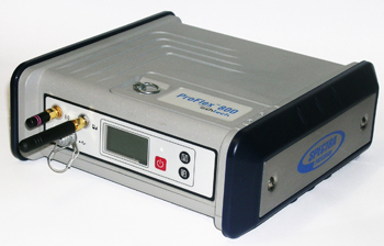
Spectra Precision introduced the new ProFlex 800, a GNSS solution with Z-Blade GNSS-centric technology. The ProFlex 800 delivers fast and reliable RTK positioning, even in environments where GNSS signals may be difficult to acquire, Spectra Precision said. Rugged and IP67 rated, the ProFlex 800 is built to withstand harsh operating conditions for a variety of positioning applications.
“The ProFlex 800 is an ideal solution for customers wanting a single GNSS receiver for multiple applications,” said François Erceau, general manager of Trimble’s Spectra Precision, Nikon and Ashtech Business Area. “It offers a unique design with a range of mounting and communications options.”
Used as a backpack rover or reference station, the ProFlex 800 with Z-Blade technology is a flexible GNSS solution for land surveying. Its innovative design also makes it ideal for hard-mounted survey applications such as coastal work, dredging, bathymetry or offshore vessel operations.
The weatherproof, high-impact-resistant molded aluminum housing allows the ProxFlex 800 to operate in harsh conditions.
In addition to a 3.5G internal cellular modem, the ProFlex 800 can use a variety of internal or external UHF modules, providing stable and reliable wireless communications. It can be used as a rover or a base without additional accessories in the field. Its Z-Blade long-range RTK capability combined with industry-leading UHF options help to ensure maximum productivity while in the field.
With its built-in Ethernet capability and embedded web server, users can access the ProFlex 800 from any computer connected to the Internet. This capability allows instant real-time multi-data streaming over an Ethernet connection to build an RTK corrections server without any additional software or equipment, the company said.
Spectra Precision ProFlex 800 CORS Receiver. The Spectra Precision ProFlex 800 is also available as a Continuously Operating Reference Station (CORS). This configuration is an optimal solution when collecting, storing and transferring high-quality GNSS raw data for post processing surveys, geodetic and other applications. Automatic sessions programming, a user-friendly Web-interface, an embedded RINEX converter, FTP push functionality and many other advanced CORS features make the ProFlex 800 CORS a powerful, robust and easy-to-use GNSS solution.
Advanced Ashtech Z-Blade Technology. Z-Blade is a new GNSS centric signal processing technology. Z-Blade uses all of the available satellite signals equally, without preference to any particular satellite constellation, maximizing the user’s ability to obtain reliable GNSS positions in tough conditions. Z-Blade allows users to receive and maintain RTK positioning even if GPS coverage is insufficient. In many work locations, just a few GPS and GLONASS satellites may be visible due to obstacles such as trees or buildings.
The ProFlex 800 is now available through the Spectra Precision global dealer network. For more information visit: www.spectraprecision.com and www.ashtech.com or email: [email protected]
Nexteq Navigation, based in Calgary, Alberta, Canada, has announced the T5A, its new flagship multifunctional GNSS handheld data collector. The device is a high-accuracy GPS unit capable of 2-centimeter accuracy using real-time kinematic (RTK) and 50-centimeters globally using Nexteq’s i-PPP technology. With the T5A, users can achieve extremely accurate and consistent results anywhere in the world with no loss in flexibility, Nexteq said, adding that the unit’s centimeter-level precision coupled with versatility allows for accurate data collection in the most diverse weather conditions.
Suitable for projects in all-environments, the T5A has a professional quality internal GPS receiver that provides accurate real-time results. Using Nexteq’s Freedom, i-PPP, or RTK technologies, the T5A data collector can provide flexible and accurate positioning in all parts of the world, Nexteq Navigation said.
The T5A has a 3.7-inch color touchscreen that is both waterproof and dustproof. The device includes features such as Bluetooth, Wi-Fi, digital cellular data and voice, microSD card slots, and a 3.0 megapixel digital camera.
Like all Nexteq Navigation GPS handhelds, the T5A is a ruggedized and tough unit. The T5A has an IP66 rating with excellent dust and water resistance.
Nexteq Navigation has release the newest version of its NexGeo software line-up: NexGeo Mobile, NexPos and NexGeo Office. Optimized for Nexteq handhelds, NexGeo Mobile integrates Nexteq Freedom, i-PPP, and RTK positioning augmentation technology into a more reliable, user-friendly data collection software, the company said. With easy display of features, background images, labeling and attributes, data is readily collected, accessed and edited. The tracking feature now allows for efficient communication and management between field workers and the office. Raw data recorded in NexGeo Mobile can be used for post processing in NexGeo Office.
Those using third-party software with a Nexteq handheld are not left behind. NexPos was created with the intent of allowing freedom in benefitting from Nexteq position augmentation technology, the company said. The NexPos software acts as a bridge, applying Freedom, i-PPP, or RTK algorithms to GPS measurements. The final positions are transferred to third-party software via virtual COM port, allowing users to benefit from improved position accuracy while NexPos runs discreetly in the background. Raw data can also be recorded and used for post processing in NexGeo Office.
On the desktop, NexGeo Office ties together collected data, attributes, and post-processing information to provide efficient project management capabilities, data organization, live field monitoring and integration with a wide variety of other software, Nexteq said. Building and maintaining a project specific database is easy using NexGeo Office: import existing data, build on the project using a Nexteq handheld and transfer it back to the office for editing. Exporting the project to ESRI or AutoCAD file formats allows for users to seamlessly continue expanding.
NexGeo software suite is available and included with all Nexteq Navigation handhelds.
Woolpert announced its Indianapolis office has been awarded two contracts totaling approximately $2 million by the City of Indianapolis Department of Public Works (DPW) to survey pavements and develop a street sign inventory using mobile mapping technology.
According to the announcement, the project requires collection of data across 3,200 miles of city streets, one of the single largest mobile light detection and ranging (LiDAR) collection efforts to date. LiDAR technology uses pulses from a laser to produce highly accurate measurements and map physical features.
“We’re proud to be at the front of using this industry-leading technology for a cost-effective approach to collecting data and developing a 3D model of the city. This truly maximizes taxpayers’ dollars by reducing the cost of a data collection effort while also providing us with the data necessary to perform government functions more efficiently, such as street rehabilitation,” said Jeremy Jobe, Woolpert project manager in Indianapolis. “Further, the dataset can be used for safety improvements through viewshed or line-of-sight analysis to proactively identify potential traffic hazards caused by the surrounding environment.”
Nearly half of the cost associated with the project is being covered through a federal grant, according to Woolpert. The city leveraged this grant to significantly reduce using local dollars for the project. Remaining funds were generated from the RebuildIndy program and other local funding sources.
Woolpert will use its Optech LYNX M1 Mobile LiDAR system to collect the data and then use that data to develop a street sign database for compliance with Federal Highway Administration’s (FHWA) Manual on Uniform Traffic Control Devices (MUTCD) requirements for sign inventories. This manual provides the U.S. standard for signs, signals and pavement markings.
“The benefit of using a high-accuracy mobile LiDAR system with survey-grade capabilities on such projects is the rich dataset that it captures from which assets can be extracted, in this case signage,” said Jobe. “The city will not only be able to use the data for its sign database, it will also be able to extract or call on the Woolpert team to extract additional features in the future without remobilizing the team and assuming associated costs or placing additional field crews in harm’s way, which provides the true value in this collection effort.”
Woolpert will team with VS Engineering and DB Engineering on the sign inventory and Dynatest on the pavement analysis. Upon completion of the project, data will be integrated with the city’s existing computerized maintenance management system.
At the Geospatial World Forum, TomTom announced the launch of its high volume batch geocoding web service. The TomTom Global Geocoder enables businesses to process large amounts of data with a single click of a button and return results quickly.
According to the announcement, geocoding is the process of converting addresses into geographic coordinates to allow location analysis. By combining geographic knowledge with business information, businesses can make smarter decisions that will lead to better products, as well as cost savings and process improvements. For example, insurance companies are relying on geocoding techniques to help set premiums and make underwriting decisions based on the physical locations of the insurance projects.
“Geocoding is part of TomTom’s DNA. With close to 30 years of experience developing global digital maps, TomTom is known for its expertise in geocoding,” said Dan Adams, Vice President, Location and Live Services at TomTom. “By launching our global batch geocoding web service, we are providing critical spatial data to fuel our customers’ analytic engines.”
The TomTom Global Geocoder offers the following benefits:
High volume results in one easy step, with no usage restrictions
International coverage enables one stop for all geocoding needs
Highly accurate, address point level matching
Fast results delivering hundreds of thousands of records per hour
Visit TomTom at Geospatial World Forum booth #19 in hall 10 to learn more about the TomTom Global Geocoder, as well as other products.