Applanix has introduced the POS LV 120, the latest version of its positioning and orientation systems for land vehicles. Using commercial Micro-Electro-Mechanical (MEMS) inertial measurement unit (IMU) technology, the Applanix POS LV 120 is a small, lightweight system and provides an economical solution for any continuous positioning and orientation application.
POS LV 120 is a fully integrated, turnkey position and orientation system, using integrated inertial technology to generate stable, reliable and repeatable positioning solutions for land-based vehicle applications, Applanix said. Redesigned to be smaller and lighter, it maintains identical data interfaces and software compatibility with the established POS LV line of products.
“With a MEMS IMU and a 220 channel, dual-antenna GNSS receiver integrated into a single enclosure, the POS LV 120 is a cost-effective GNSS-Inertial solution designed to support many types of land-based mobile mapping projects,” said Kevin Andrews, product manager for Land Products at Applanix. “The integrated system is smaller than the standard POS LV computer system (PCS), making it ideal for use in lightweight applications such as robotics, autonomous vehicles, centerline mapping, asset mapping and short-range direct georeferencing.”
POS LV 120 is available now through the Applanix sales network.
Septentrio announces the full support of TERRASTAR wide-area differential and Precise Point Positioning (PPP) capabilities in some of its receivers. The Septentrio AsteRx2eL is an all-in-view dual-frequency GPS/GLONASS receiver, featuring an integrated L-band modem to receive TERRASTAR data transmitted by satellite and field-proven dm-accurate positioning using this data. AsteRx2eL also features GNSS+ technology, a unique combination of industrial grade performance algorithms, to better serve high-precision positioning needs even in the most severe conditions, Septentrio said.
Support of TERRASTAR-M and TERRASTAR-D allows precise position calculation anywhere on the globe, Septentrio said. TERRASTAR services achieve accuracy levels down to 10 cm without the use of extra communication such as radio or mobile. Powered by TERRASTAR services, AsteRx2eL provides a high level of flexibility for consistent dm-level accuracy everywhere on earth and cm-level where local RTK corrections are available. Septentrio multi-constellation receivers will provide position accuracy and high-availability independently of local infrastructure for the various applications in any of the markets that they traditionally serve:
Land and aerial survey and mapping
Machine control for agriculture, construction and mining
Precise navigation for land, sea and air
‘The introduction of support for TERRASTAR offers our customers an important additional option for accurate positioning, notably in the absence of local infrastructure,” Peter Grognard, founder and CEO of Septentrio Satellite Navigation, said. “It has been a pleasure for us at Septentrio to closely collaborate with the great team at TERRASTAR to develop and deliver a strong new value proposition with robust industrial performance everywhere on the globe.”
Trimble introduced today its next-generation GNSS surveying solution — the Trimble R10 — at the INTERGEO 2012 conference on geodesy, geoinformatics and land management.
As the smallest and lightest receiver in its class, the Trimble R10 combines powerful features and groundbreaking technologies including Trimble HD-GNSS, Trimble SurePoint, Trimble 360, and Trimble xFill to provide surveyors increased productivity, the company said. User-friendly features such as a quick-release adaptor and the ability to configure the receiver from a smartphone make it easy to deploy and use as a base station or rover, Trimble said.
Trimble also released new versions of its field and office software — Trimble Access 2012.20 and Trimble Business Center 2.80 — to extend Trimble’s Connected Site survey solution, which enables surveyors to collect and process reliable data more efficiently.
“Faster results, better reliability and improved overall performance are what our customers have come to expect,” said Anders Rhodin, general manager of Trimble’s Survey Division. “With the introduction of the Trimble R10, Trimble is delivering next-generation capabilities in a smaller, lighter and feature-packed system that is unmatched in the industry today.”
The Trimble HD-GNSS processing engine integrated in the Trimble R10 is a new generation of core positioning technology, Trimble said. Trimble HD-GNSS surpasses traditional fixed/float techniques to provide a more accurate assessment of error estimates than traditional GNSS processing engines. Measurements collected with Trimble HD-GNSS are precision-based so surveyors can confidently collect data in challenging environments where they may have been unable to collect data before. Reduced convergence times and instantaneous point measurements allow surveyors to start measuring sooner and up to 60 percent faster.
Supporting 440 channels with two built-in Trimble Maxwell 6 chips, the Trimble R10’s integrated Trimble 360 technology allows consistent and reliable tracking of available GNSS satellite signals for existing and currently planned GNSS constellations and augmentations.
Trimble has extended its Trimble SurePoint technology, a cornerstone of the S-Series total stations, to the new GNSS surveying system. The incorporation of this technology simplifies the survey data collection workflow by providing faster measurements, increased accuracy and greater quality control. The Trimble R10 includes an electronic bubble that appears on the controller display so that all measurement information is displayed in one place. Trimble SurePoint constantly monitors the pole tilt and protects surveyors from collecting erroneous data by only allowing data to be stored when the survey pole is plumb. Simultaneously, pole tilt angle values are stored for every point collected to ensure data traceability.
Powered by Trimble RTX technology, new Trimble xFill leverages a worldwide network of Trimble GNSS reference stations to deliver position information via geostationary satellites. xFill seamlessly “fills in” for RTK or VRS corrections in the event of a temporary connection outage such as a radio black spot so users experience less downtime in the field.
Designed for ease of use and durability, the Trimble R10 offers the ruggedness and reliability. Additional features include multiple connectivity capabilities such as Wi-Fi and 3G cellular connectivity, a lithium-ion battery, an integrated GNSS antenna, 4 GB internal memory, and an internal 2 Watt radio.
Trimble Access is a field solution that enables wireless connectivity between the project team members to expedite data collection, processing, analysis, and project information delivery through improved workflows, collaboration and control. The complete solution speeds both typical and specialized surveying tasks, and enables easy and fast two-way information sharing between the field survey crew and the office. Surveys can be completed faster with less time spent traveling back and forth to the office. Management and field crews can closely collaborate by viewing the same information in near real-time.
Trimble Access version 2012.20 offers new functionality compatible with the Trimble R10, including:
Tilt auto-measure: Topo point or Rapid point measurements can now be automatically started when the pole is plumbed to within a predefined tilt tolerance. Coupled with auto store, hundreds of points can be measured with only one tap on Measure.
Tilt warnings: Users are now notified if the pole moves outside a predefined tilt tolerance during point measurement.
Tilt distances: Measurements collected with the Trimble R10 can now have an associated tilt distance providing additional quality control information. Use the QC Graph for a quick visual check to see the range of tilt distance errors for any particular job.
eBubble display: An electronic bubble can be used instead of a traditional pole bubble. The eBubble enables a clearer, easier and more accessible display of the bubble providing the surveyor just one place to focus when leveling and measuring.
In the Office – Trimble Business Center 2.80
Trimble Business Center office software is a complete surveying office suite designed to manage, analyze and process all field survey data, including data from optical instruments (total stations and levels), GPS/GNSS and spatial stations (imaging and 3D scanning data).
Version 2.80 advances the capabilities of surveying offices with key new functionality, including:
Trimble R10 support: Users can import RTK and PPK tilt magnitude and quality data from a Trimble Access Job or JobXML file and also export this data using the Custom Exporter. The new version also has the capability to Import Trimble Access Job or Job XML files containing xFill observations.
Ribbon menu layout: A new ribbon menu layout and quick access toolbar help users quickly locate commands required to complete a task for an improved user experience.
Microsoft Windows 8 support: Version 2.80 is compatible with the Microsoft Windows 8 Operating System.
Station View field-of-vision indicator: Users can view which Station Views are open and in which direction they are facing. The indicators improve workflows for measuring points photogrammetrically with images from Trimble VISION instruments.
The Trimble R10 GNSS System can be ordered beginning mid October 2012. Shipping is expected to begin during the latter part of the fourth quarter in 2012. Trimble Access software version 2012.20 and Trimble Business Center Software version 2.80 are available now through Trimble’s Survey Distribution Channel.
Trimble’s Connected Site solutions for surveyors create seamless working relationships among Trimble products, technologies and services. Through the Connected Site, Trimble is focused on providing solutions that address the customers’ full work processes. By carefully combining technology innovation with a deep understanding of the users’ workflows, data integration and maintenance across the lifecycle of projects, Trimble helps surveyors reach new levels of productivity for their businesses.
The enormous importance of geoinformation for the energy revolution, cloud computing, open data and enterprise applications based on Microsoft Bing Maps — these are just some of the many fascinating issues that will take center stage at INTERGEO in Hanover, Germany, October 9-11. Host DVW e.V. — the German Society for Geodesy, Geoinformation and Land Management — is pooling issues relevant to its specialist areas at the trade fair and conference and is set to welcome some 16,000 visitors, including 1,200 conference delegates. The international meeting takes place in a different German city each year, with about 520 international companies, 40 percent of which are based outside Germany.
GPS World’s Editor-in-Chief Alan Cameron, International Account Executive Chris Litton, and Contributing Editor for Survey/GIS Eric Gakstatter are in attendance.
On the first day of the fair, Cornelia Rogall-Grothe, state secretary at the German Federal Ministry of the Interior, is launching the first national INSPIRE Conference with a speech on “INSPIRE: the driving force behind the national geodata infrastructure.”
This year, for the first time, INTERGEO will incorporate the conference of the Council of European Geodetic Surveyors (CLGE), which will take place Thursday. The third conference of its type brings together surveyors from 36 member countries in Hanover.
The Navigation Conference is also being held as part of INTERGEO for the second time. Once again, the event will seek to utilize synergies between navigation, IT and geoinformation.
The conference is focusing on the latest topics and many technical solutions for capturing up-to-date geoinformation. Cutting-edge sensor technology will be presented along with the latest systems solutions.
Today, Hemisphere GPS introduces the Vector VS330 and Vector VS131 GPS compass products that provide high performance heading, position, heave, and attitude data. The new Vector products are designed for professional marine applications such as hydrographic and bathymetric surveys, dredging, oil platform positioning, and buoys that demand a high level of 3D positioning accuracies.
Based on Hemisphere GPS’ Eclipse GNSS technology, Vector VS330 uses the most accurate differential corrections including RTK, L-band, SBAS, and beacon. The smart intelligence from our MFA firmware provides differential solutions by automatically switching to the next best differential source if the original source is no longer available, Hemisphere GPS said.
Vector VS330 is Hemisphere GPS’ flagship receiver and computes heading information with better than 0.01 degrees accuracy when using a 10-meter antenna separation. Positioning accuracy is better than one centimeter in RTK mode or four centimeters when using OmniSTAR HP corrections. Vector VS330 also provides five-centimeter RTK heave and 0.01 degree pitch and roll accuracies.
Combining Hemisphere GPS’ Crescent Vector and LX-2 receivers with two separate antennas, the Vector VS131 computes heading information with better than 0.03 degrees accuracy when using a five-meter antenna separation and better than 50 centimeter position accuracy when using L-band, SBAS, or beacon corrections. Vector VS131 accepts most differential correction signals for unparalleled flexibility to obtain sub-meter positioning in all regions.
The ruggedness of the new Vector enclosure also makes it suitable for more harsh environment installations like machine-control applications, including agriculture, heavy construction equipment, mining equipment, unmanned vehicles, cranes, and other machinery or industries that require very accurate heading and positioning solutions. The Vector’s versatility for providing heading, position, heave, and motion makes it directly compatible with the most popular hydrographic and side scan survey packages. Vector VS330 and VS131 include an intuitive and easy-to-follow user interface to facilitate fast installations.
“Vector VS330 and Vector VS131 are premium additions to Hemisphere GPS’ Vector series product line,” said Phil Gabriel, vice president and general manager, Precision Products, for Hemisphere GPS. “As the demand for more rugged and precise GPS equipment increases, we are meeting this demand by exceeding the accuracy of competitors’ products while being significantly more affordable.”
Vector VS330 and Vector VS131 will be featured by Hemisphere GPS in hall 9, stand B.62 at the INTERGEO Conference and Trade Fair in Hanover, Germany, from October 9-11. Both products will be available for shipping in November through the Hemisphere GPS Precision Products global dealer network.
Today, Hemisphere GPS announced the new S320 network rover and XF2 handheld data collector. With support for network RTK corrections, the S320 network rover is an integrated solution that simplifies land surveying applications by eliminating the need for a base station and radio modem, the company said.
A variety of public and private organizations post RTK network corrections on the Internet. The S320 GSM cellular communication connects users to Internet-based corrections and processes the data to achieve centimeter-level positioning performance. As a result, users do not need to purchase and operate their own RTK base station and radio modem connection. Users also have the option of using satellite-based L-band corrections for high-precision mapping jobs.
Hemisphere GPS’ XF2 next-generation data collector combined with Carlson SurvCE software provides a familiar and proven interface to the S320. The two products communicate through a Bluetooth wireless connection and attach to a standard survey pole making the system portable and simple to operate, Hemisphere GPS said.
“Hemisphere GPS’ S320 network rover and new XF2 provide a very powerful and cost-effective surveying and mapping solution,” says Phil Gabriel, vice president and general manager of Precision Products for Hemisphere GPS. “The rugged design and versatile performance of our S320 makes it a great fit for a variety of applications.”
Launched one year ago, S320 combines the advanced GNSS receiver performance of Hemisphere GPS’ Eclipse technology, precise geodetic antenna, wireless communication and batteries in a portable, rugged unit. Compatible with a variety of existing surveying equipment, S320 is a multi-GNSS positioning system designed for applications in GIS, mining, construction, mapping, land, and marine surveying.
The S320 network rover and XF2 will be featured by Hemisphere GPS in hall 9, stand B62 at the INTERGEO Conference and Trade Fair in Hanover, Germany from October 9-11. The products are available through the Hemisphere GPS Precision Products global dealer network.
NovAtel Inc. announced at ION the addition of SPAN GNSS/Inertial Navigation System (INS) technology to its OEM6 GNSS receiver platform. NovAtel’s SPAN technology tightly couples precision GNSS receivers with robust inertial measurement units (IMUs) to provide reliable, continuously available, position, velocity and attitude (roll, pitch, yaw), even during short periods of time when satellite signals are blocked or unavailable.
The release of SPAN on OEM6 provides SPAN OEM customers with new features and functionality previously unavailable on NovAtel’s OEMV based SPAN platform, including ALIGN GNSS heading determination, API, RAIM, and GPS+GLONASS positioning.
Jason Hamilton, director of Marketing at NovAtel, stated, “SPAN on OEM6 builds on our core GNSS platform, taking features and functionality from our six series and adding them to our SPAN technology.” He added, “SPAN on OEM6 improves positioning performance in difficult GNSS environments over NovAtel’s past generations of products, greatly improving the ability to bridge GNSS outages, and allowing users to operate with higher confidence in challenging environments.”
NovAtel’s SPAN technology will be supported on OEM615 and OEM628 board level receivers, and the FlexPak6 receiver which gives integrators a rugged enclosed platform that can be paired with the company’s complete range of IMU sensors.
The OEM615 and 628 boards replace NovAtel’s legacy OEMV receivers to provide integrators a new platform for developing and embedding SPAN into their applications. Existing OEM6 customers can now upgrade their receiver to become full GNSS/INS SPAN platforms.
Interested parties can visit NovAtel at Booth “F” at ION 2012 to learn more about this new product offering. Shipments of OEM6 SPAN enabled receivers will begin September 2012. Further information can be found on the company’s website at novatel.com or through a company representative which can be located under the “Where to Buy” tab of the company website.
Leica Geosystems Inc. has announced it has significantly upgraded and expanded the coverage of its Leica SmartNet RTK Network in California, making real-time GNSS correction available to 82 percent of the state’s population. A GPS/GLONASS reference station network, Leica SmartNet gives GNSS users access to differential correction for any measurement application without the use of a base station.
“Leica Geosystems has upgraded the SmartNet California network to improve both the quality and geographic coverage of GNSS correction throughout the state,” said Wendy Watson, Director, Reference Station Operations. “All SmartNet California stations are now GPS and GLONASS capable with additional enhancements being made to accommodate future positioning satellite constellations.”
A Real-Time Kinematic (RTK) network is a series of permanent GPS and/or GNSS receiver stations whose combined data is used to generate corrections for rover GNSS receivers operating in the coverage area. The rover GNSS unit uses this correction data to improve the native accuracy of its measurement and location calculations. Strategic installation of SmartNet stations throughout California provides wireless RTK data access to nearly every GNSS user in the major population centers of the state.
In the past six months, Leica Geosystems has installed six new stations and upgraded eight more to strengthen the geometry of the California network. Most new installations have included the Leica GR10 next-generation GNSS reference station receiver and Leica AR10 antenna with integrated radome. New stations have been installed in North Hollywood, Santa Monica, Half Moon Bay, Santa Cruz, Santa Rosa, and Yuba City. Total population coverage in the state with SmartNet now exceeds 30 million.
“Wireless access to RTK data without a base station is an enormous time savings for surveyors, GIS professionals or other GNSS users who need to improve the native accuracy of their location measurements,” said Wendy Watson, Director, Reference Station Operations. “For any measurement application in California, SmartNet makes this data accessible instantly and affordably.”
Available through several subscription plan options, SmartNet California is relied upon by GNSS users in surveying, mapping, construction, engineering, agriculture and GIS.
SuperGeo announced that SuperGIS Server 3.1 Value Edition, a GIS server developed by SuperGeo for enterprises, supports the integration with OpenStreetMap.
According to the announcement, SuperGIS Server 3.1 is designed for enabling the organizations to create, manage, integrate and publish a variety of spatial services. Therefore, the spatial data in all types as well as GIS functions can be applied to desktop, mobile and web applications over the Internet.
The company reports that to provide developers with a flexible server structure, the newest SuperGIS Server 3.1 Value Edition aims to optimize the ability to integrate with other sources. In addition to Google Map services and the services published by ArcGIS Server, the services, published by SuperGIS Server 3.1, can be overlaid with OpenStreetMap services. Administrators are able to publish map services and overlay these services with OpenStreetMap after building SuperGIS Server website. Therefore, the contents of the map website would be richer and more flexible.
Esri, PCI Geomatics, MDA, and RapidEye announced their new Natural Resources Imagery Grant Program. The grant program will provide software, data, and training for detecting and analyzing land-cover change through the combined use of geographic information system (GIS), image processing, and remote-sensing technologies.
According to the announcement, the program is designed to foster innovative approaches that solve natural resources management problems, the Natural Resources Imagery Grant Program will provide 20 grants valued at $100,000 each. The grant includes the following:
Esri GIS software and training
PCI Geomatics imagery processing and analysis software and training
“GIS and image processing are mission-critical technologies in natural resources management,” said Jack Dangermond, president, Esri. “This grant opportunity will help organizations expand their existing imagery or GIS infrastructure and more efficiently support sustainable land-use management.”
Companies, educational institutions, nongovernmental organizations (NGOs), state and regional governments, or tribal governments within the United States may apply. Eligible projects are those that focus on remotely sensed imagery beyond the visible spectrum. Preferred projects will also demonstrate increased efficiency, productivity, or accuracy.
“Technology leaders and innovators should be presented with opportunities to advance their resources projects,” said Terry Maloney, president and CEO, PCI Geomatics. “This imagery grant program will bring solutions to the natural resources industries through inventive and operational use of satellite imagery.”
Applications for the Natural Resources Imagery Grant Program will be accepted beginning in September 2012 and ending November 16, 2012. Learn more at esri.com/imagerygrant.
Topcon Positioning Systems has unveiled the HiPer SR — an advanced GNSS RTK receiver that Topcon describes as having “the most compact and lightweight design of any fully integrated precision receiver — ever.”
With the HiPer SR, Topcon is expanding the delivery of high-accuracy RTK technology to a variety of users — surveyors who need a tool for small boundary or stakeout work, non-traditional users such as landscape architects who need a low-cost mapping solution, and law enforcement or any others requiring high-accuracy 3D positioning.
Cable-free and weighing under 2 pounds, the rugged and fully integrated design delivers a 1,000-foot working radius through Topcon’s new LongLink technology. The LongLink wireless data link was developed specifically for the HiPer SR, and provides reliable and interference-free RTK base-to-rover communications that don’t require an FCC license to operate, Topcon said. Base and rover units can be used interchangeably.
The HiPer SR can also be a dedicated network rover. All standard RTK correction formats and network protocols are supported, and a comprehensive range of field workflows are realized with the Magnet family of cloud-enabled software solutions.
The HiPer SR’s 226-channel Vanguard GNSS chip provides precision measurement and advanced multipath rejection, offers support for all modernized GNSS constellations, and incorporates Topcon’s patented Universal Tracking Channel technology whereby any channel can track any available signal, reducing power consumption and system weight. As more GNSS signals come online, this flexibility enables the 226-channel Vanguard design to scale up and track more signals than other GNSS systems.
Additional features of the HiPer SR include:
Quartz Lock Loop technology. Designed by Topcon engineers for superior GNSS tracking in high-vibration environments, such as on a four wheeler;
Capable of simultaneous LongLink operation with multiple rovers;
Sealed battery pack provides more than 15 hours of operation;
Lightweight and shock-resistant magnesium alloy housing, allowing the HiPer SR to take a 6 ft. (2m) pole drop onto concrete
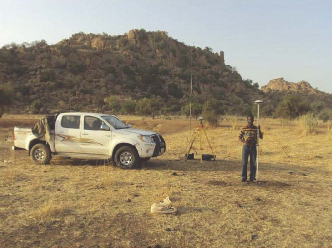
Surveyors install and configure a base and rover for a 13,000-hectare survey of the Plains Kogoni in Mali.
In the heart of landlocked Mali, between the Atlantic Ocean 800 miles to the south and the Sahara desert to the north, lays the extraordinary Inner Niger River Delta, also known as the Macina, a 1.8 million hectare oasis of lakes and floodplains with a vast potential for hydro agriculture.
CIRA, a major West African consulting engineering firm, working on behalf of the Office du Niger, a quasi-governmental Mali company charged with managing more than100,000 hectares of irrigated delta land, has completed surveying an additional 25,000 hectares for hydro-agriculture development.
Created in 1991, CIRA is an engineering and applied research consulting firm working in transportation, hydraulics, civil engineering and the environment. Based in Bamako, Mali, the firm works in more than 15 African countries, primarily in West Africa, Central Africa and East Africa.
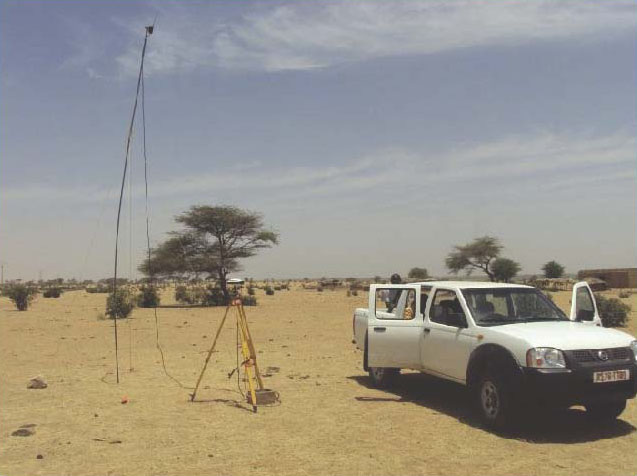
In the course of two months during the dry season, two CIRA survey teams, each equipped with three Spectra Precision ProMark 500s, a base station, and two rovers connected via UHF, completed the entire 25,000 hectare survey collecting four points in x, y, and z per hectare to produce a digital model. The model enabled the production of rough pre-study with all plans and a detailed pre-project CAD drawings for drainage, irrigation canals, and related infrastructures.
A very short eight-month contractual time set to complete the different studies meant that the land survey study would have to be completed as quickly as possible. The first thought was to use aerial photography combined with LIDAR, but setting this up would have taken too long, according to a CIRA spokesperson. Instead, CIRCA chose to employ differential GNSS, using base and rovers working in real-time kinematic. CIRA’s experience suggested the firm would achieve reliable results much quicker using only optical total stations. CIRA elected to use Ashtech ProMark 500 GNSS receivers for the project. From experience, they knew the models were easy to set up and use, lightweight, offered long battery life in the field, and field to office data transfer would be easy. Their expectations were met, and the job was completed within two months and on time.
The ProMark 500 RTK survey system provides short time to fix, long-range RTK and solution reliability. Its BLADE technology provides multi-constellation signal processing with the use of SBAS and GLONASS ranging signals to strenghten the GPS solution.
Trimble acquired Ashtech in 2011, making it part of Spectra Precision.
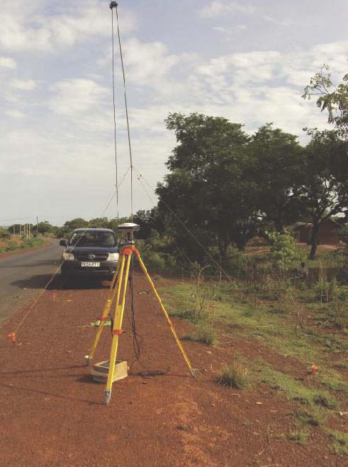
Setting up bitter points for calibration of satellite images on the corridor Sarh – Abeche in Chad (800km).Reference station during the survey topo Richard Toll road – N Dioum (120 miles) in Senegal.A reference station during the survey topo Zégoua Sikasso road (95 km) in Mali.