Tag: surveying

  • Trimble Introduces All-In-One Device for Mobile Communications and Surveying Data Collection

    Trimble Slate Controller.
    Trimble Slate Controller.

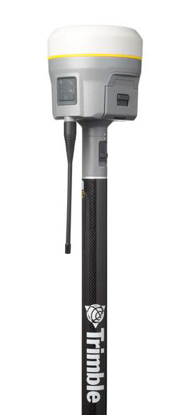
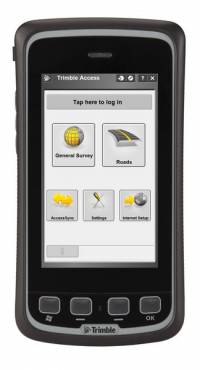
    Trimble has introduced an all-in-one device for mobile communications and surveying data collection — the Trimble Slate Controller. The Trimble Slate Controller combines the convenience and ease-of-use of a smartphone with rugged durability. Optimized for Trimble Access field software and the Trimble R4 GNSS receiver, the Trimble Slate Controller supports a surveyor’s everyday workflows.

    “Surveyors require mobile, rugged solutions that can readily withstand and perform in the toughest of conditions,” said Erik Arvesen, vice president of Trimble’s Survey Division. “With the introduction of the Trimble Slate Controller, we are providing a rugged handheld device designed to run survey workflows while also delivering the capabilities and convenience of a smartphone.”

    Offering voice, SMS text, and 3.75G cellular data transfer capabilities on GSM cellular networks worldwide, the rugged Trimble Slate Controller enables enhanced connectivity in the field. Its wireless communication capabilities keep surveyors connected to the office. An integrated 8-megapixel camera offers enhanced job documentation and point attribution by providing geotagged, high-quality digital photos. 

    The Trimble Slate Controller’s slim, ergonomic design is easy to hold while its screen provides superior sunlight readability enabling all-day use by survey professionals. Designed to withstand even tough conditions, a 4.3-inch capacitive touch Gorilla glass display covers the entire front surface, increasing readability without sacrificing durability.

    Trimble Access field software available on the Trimble Slate Controller offers a variety of features and capabilities to streamline topographic, stakeout, control and other surveying applications. Partnered with Trimble Access and the Trimble R4 GNSS receiver, the Trimble Slate Controller provides a dedicated GNSS solution that is effective for both real time and post-processed GNSS surveys, Trimble said.


  • Trimble Increases Functionality Across GNSS Survey Portfolio

    R10_studio_back_face_right
    Trimble

    Trimble announced today functionality updates to its integrated GNSS survey receiver portfolio, which includes the Trimble R4, Trimble R6, Trimble R8 GNSS systems and is rounded out by the recently released Trimble R10 GNSS System (pictured at right).

    The updates include increased satellite tracking and real-time kinematic (RTK) performance. These improvements modernize the integrated receiver portfolio to add functionality, flexibility and capability as well as more options for surveyors, Trimble said.

    “With the introduction of the next-generation Trimble R10 GNSS system, we felt it was an ideal opportunity to modernize the complete integrated receiver portfolio,” said Erik Arvesen, vice president of Trimble’s Survey Division. “The additional functionality in the Trimble R4, R6 and R8 provide surveyors with more capability, flexibility and additional receiver options to meet their ever-changing business needs.”

    Trimble R8 GNSS System. The Trimble R8 includes integrated Trimble Maxwell 6 ASICs offering 440 channels. Powered by Trimble 360 technology, the Trimble R8 provides consistent and reliable tracking of signals for all existing GNSS constellations and augmentation systems, including GPS, GLONASS, Galileo, BeiDou and QZSS. Using the Trimble R8, surveyors can connect directly to the controller, receive RTK network corrections and access the Internet via comprehensive communication options.

    Trimble R6 GNSS System. Featuring Trimble R-Track satellite tracking technology, a Trimble Maxwell 6 ASIC with 220 channels and support for all GPS and QZSS signals with GNSS upgrade options, the Trimble R6 provides surveyors with a completely scalable and flexible solution. The Trimble R6 supports GPS L1, L2, L2C, and L5 signals and QZSS as standard and offers upgrade options to support GLONASS, Galileo and BeiDou signals. The Trimble R6 delivers the accuracy and reliability required for precision surveying with superior tracking and RTK performance.

    Trimble R4 GNSS System. Designed for use with the new Trimble Slate Controller and Trimble Access field software, the Trimble R4 GNSS System provides a dedicated and reliable GNSS solution that is effective for both real-time and post-processed GNSS surveys. The Trimble R4 now supports GPS L1, L2, and L2C and QZSS signals as standard and also offers GLONASS, Galileo and BeiDou support upgrade options. The system includes Trimble R-Track technology and a Trimble Maxwell 6 ASIC with 220 channels.

    Trimble R10 GNSS System. The Trimble R10 GNSS system is the premier solution of the integrated survey receiver portfolio. Designed to increase  productivity, the Trimble R10 provides powerful functionality, including Trimble 360 receiver technology, precise position capture with Trimble SurePoint technology, the cutting-edge Trimble HD-GNSS processing engine and Trimble xFill bridging technology to “fill in” for RTK corrections in the event of temporary radio or Internet connection outages.

    The updated configurations of the Trimble R4, R6 and R8 as well as the Trimble R10 GNSS system are available now through Trimble’s Survey Distribution Channel.

  • Trimble Acquires Penmap Software for Survey and Cadastral Markets

    Trimble has acquired a suite of software solutions from Penmap.com Ltd. of Bradford, United Kingdom. Penmap.com’s solutions include both office and field data collection software specifically designed for the cadastral and surveying markets. The comprehensive software suite enables Trimble to further address local application requirements and customer needs by providing complete customized surveying software solutions for the cadastral market, the company said. Financial terms were not disclosed.

    The software solutions include:

    Penmap encore: A new solution specifically designed for PDAs and handheld GPS receivers running Windows Mobile operating system. The software’s revolutionary user-friendly interface takes advantage of virtually the entire display screen to maximize map real-estate and is designed for fingertip operation.

    Penmap encoreT: A new premium data collection software specifically designed for tablet PCs running Windows 8, 7, Vista or XP operating system. Its user interface shows collected data on the map in real-time. This feature gives users peace of mind that they have collected data correctly before leaving the site, Trimble said.

    Penmap Office: An intuitive office platform for Penmap encore software. The office software streamlines the land administration professional’s workflow — from project preparation and importing data to managing large raster and vector background maps collected in the field, Trimble said.

    “Penmap.com has built a very close and successful relationship as a customer of Trimble for many years,” said Erik Schütz, managing director for Penmap.com Ltd. “Since Penmap.com was founded, our vision has been to focus on the local requirements of the regional markets we serve and provide those customers with a fine-tuned and easy-to-use solution. The software is an ideal fit within the Trimble portfolio of solutions to address the cadastral market.”

    “The acquisition of Penmap.com’s software suite of office and field solutions reinforces Trimble’s continued commitment to the cadastral market, as well as our focus on providing customers with complete solutions that are customized for local market requirements,” said Matt Delano, business area director for Trimble’s Land Administration Solutions. “Penmap.com’s strength lies in its ability to customize surveying software applications for regional markets, providing users the most intuitive work processes for optimal efficiency and productivity, making it a perfect fit for our customers.”

  • HiPer V Featuring Vanguard Technology Offered by Topcon

    HiPer V Featuring Vanguard Technology Offered by Topcon

    Topcon has introduced the HiPer V receiver, which features Topcon’s Vanguard technology. The HiPer V provides users with the choice of GPS and GLONASS signals (as well as Galileo when operationally available), and also includes a variety of choices of internal radio, cellular and Bluetooth communication options and what Topcon calls a state-of-the-art power supply.

    The core of the HiPer V is the new Vanguard GNSS technology, according to Ewout Korpershoek, Topcon senior vice president and chief marketing officer. With its 226 channels and Universal Tracking, the Vanguard chipset is future proof, as it will track signals from all available and currently planned GPS, GLONASS and Galileo satellites.

    “Topcon’s Universal Tracking provides a whole new definition of ‘channel technology.’ There is nothing available like it. Universal Tracking allows a single receiver channel to ‘automatically’ select and track any satellite signal,” Korpershoek said. “Because our channels are not pre-programmed to receive only one specific signal or a type of signal, Topcon users will always receive the maximum number of signals at any given time. In addition, Topcon’s Universal Tracking will automatically weigh the best combination of available signals based on health, geometry and application, providing unmatched accuracy, speed of initialization and fixing. HiPer V will work at places where other receivers will not, at highest accuracy, and with greatest ease of use.”

    Other features include the rugged, durable magnesium alloy housing, the choice of communication options, “and longest life rechargeable battery while maintaining the lightest weight in its class,” Korpershoek said.

  • Call for Participation: Round 2 of NGS Kinematic GPS Challenge

    NOAA’s National Geodetic Survey (NGS) is conducting a 12-year project, called Gravity for the Redefinition of the American Vertical Datum (GRAV-D), to redefine the vertical datum of the United States by flying airborne gravity missions. The accuracy of the resulting vertical datum depends directly on the quality of the aircraft’s GNSS position solutions.

    In August 2010, NGS issued a Kinematic GPS Challenge to seek community input on the best practices for processing this large positioning data volume. Ten international groups answered the call, submitting 16 different position solutions calculated with a variety of software and techniques. However, the majority of solutions were corrupted by a characteristic “sawtooth” pattern which was tracked back to the aircraft receiver used in the initial challenge; for this challenge reissue, a second onboard GNSS receiver is used.  Also in this new call for participation, inertial measurement unit (IMU) data are made available for joint GPS+IMU processing.

    “To further facilitate our software and method development, we invite interested researchers and practitioners to compute and submit solutions from samples of actual GRAV-D data,” said Gerry Mader and Theresa Diehl, NGS, in an invitation email. “In this new call, NGS requests that all participants submit a GPS-only solution utilizing the new aircraft GPS data. For those able to process with IMU data, we request additional submission of a second IMU+GPS solution. NGS would like to receive all solutions by April 1, 2013.

    “This is a strictly voluntary exercise for those interested in such a comparison and we will share our results with the participants. We are also interested in possibly co-authoring a publication with the participants on the topic if results are significant.”

    Detailed information on the challenge is available here:

    Those interested in participating should read through the PDF (link above), then email Gerry Mader (gerald.l.mader at noaa.gov) and Theresa Diehl (theresa.diehl at noaa.gov) with any questions.

  • Hexagon to Acquire Russia’s NAVGEOCOM

    Hexagon has entered into a definitive agreement to acquire all outstanding shares in Russia-based Navgeocom. The company is the largest distributor for Leica Geosystems, a Hexagon brand, in the Russian Federation.

    Founded in 1997, Navgeocom has grown into one of the top-tier distributors of surveying and mapping products in Russia. The acquisition marks another step in Hexagon’s global distribution strategy, which aims to establish a strong direct presence in all key markets.

    “Strategically, the acquisition of Navgeocom is a great fit for Hexagon and yet another step toward expanding our presence in Russia and Central Asia. Furthermore, Russia is entering into a phase of significant investment in transport infrastructure,” said Hexagon AB President and CEO Ola Rollén. “In addition to Russian highways, it includes significantly increasing the size of Moscow and surrounding its perimeter with a motorway, an expressway and high-speed rail system between Moscow and St. Petersburg, and an international transport passage programme between Europe and West China. Coupled with the acquisition, these projects provide substantial growth opportunities across Hexagon and improve our ability to serve customers in the Russian Federation.”

    The transaction is subject to regulatory approval and customary closing conditions. The transaction is expected to close as of end of February 2013 and will contribute to Hexagon’s earnings. Excluding intercompany revenue, the company’s turnover for 2012 amounted to approximately 10 MEUR.

  • Leica Geosystems Opens Online Store

    Leica Geosystems Inc. has announced the launch of the e-commerce site for Leica Geosystems Solutions Centers. The grand opening of the Leica Geosystems Solutions Center is marked by an unprecedented online-only promotion.

    Providing 24/7 personalized access to the products essential to the surveying, engineering, and construction industries, the site is a resource for more than purchases. It also enables customers to compare thousands of products based on features, shipping options and availability, and to create wish lists.

    The Leica Geosystems Solutions Centers e-commerce site offers a range of supplies, accessories and rentals, from paint and flagging, safety supplies, total stations and GPS systems for surveying, construction lasers and building layout systems. Relevant products and pricing are presented based on each customer’s unique profile, and subscription and quick-order capabilities make it easy to reorder frequently needed products.

    “We are committed to continually delivering value to our customers, and it is exciting to respond to customer needs by bringing this e-commerce site to the market,” said Mike Strom, general manager, Solutions Centers for Leica Geosystems. “Our customers are busy, and they often need to place orders outside of standard business hours. Our new e-commerce website provides customers a more convenient way to buy from us, and we will be offering online-only promotions on a regular basis — similar to the tremendous grand opening deals — so it’s easier than ever for customers to begin reaping the benefits of Leica Geosystems solutions.”

    The Leica Geosystems Solutions Center is factory-owned and operated, which guarantees that customers will receive the quality products and service expected from Leica Geosystems, the company said. Additionally, because support is critical at every step of the way, even during the purchase process, the site features multiple avenues to online support: customers get answers from factory-trained experts.

  • ArcGIS for Windows Mobile Simplifies Field Data Collection

    Esri has released ArcGIS for Windows Mobile 3.1, coinciding with the release of Trimble Positions field collection software. The Trimble Positions software suite extends the ArcGIS for Windows Mobile application and software developer kit (SDK) with support for high-accuracy GNSS mobile GIS data collection.

    The Trimble Positions software suite is designed for users who require high-accuracy data collection workflows using Esri’s ArcGIS for Windows Mobile technology. The latest version of ArcGIS for Windows Mobile, combined with Trimble Positions software, simplifies field collection activities and requires little to no GNSS or GIS data collection experience, Esri said. ArcGIS for Windows Mobile and Trimble Positions support both real-time and postprocessing workflows, streamlining the process of collecting GPS data.

    With ArcGIS for Windows Mobile, data collected with Trimble Positions can be automatically synced to an enterprise server when Trimble Positions Desktop is used to manage data from incoming field crews. Office administrators can easily check for new sessions, differentially correct the data, and verify that it meets accuracy requirements before updating the enterprise database at the touch of a button, Esri said.

  • Trimble Makes RTX Coverage Announcement at Trimble Dimensions

    Trimble has expanded coverage of its satellite-delivered Trimble RTX technology for surveyors to most of the world. Trimble has also introduced post-processing capability for its CenterPoint RTX positioning service for farmers. Both announcements were made at the Trimble Dimensions 2012 conference being held in Las Vegas this week.

    RTX technology enables Trimble xFill, a new technique in RTK and VRS surveying that allows surveyors to continue working in the event the primary RTK or VRS correction stream is not available.

    Trimble RTX technology, first introduced in 2011, combines real-time data and positioning algorithms to deliver centimeter accuracy around the world. While RTX technology is available worldwide via IP and cellular delivery methods, Trimble RTX has been available via satellite L-Band only in North and South America. Now, the expanded satellite coverage includes most of Europe, Russia, and the Commonwealth of Independent States (CIS), Africa, Asia, and Australasia.

    Powered by Trimble RTX technology, Trimble xFill, a feature integrated into the new Trimble R10 GNSS Receiver, enables a new and innovative technique in RTK surveying, according to Trimble. It seamlessly “fills in” for RTK or VRS corrections for up to five minutes in the event of a temporary connection outage with the primary correction source. Minimizing downtime, Trimble xFill enables higher productivity for field survey crews, allowing them to continue working until radio or cellular connectivity is restored, Trimble said.

    “The expanded coverage of satellite-delivered Trimble RTX technology further extends our commitment to providing different ways of realizing high accuracy positioning solutions,” said Patricia Boothe, general manager of Trimble’s Positioning Services Division. “The power of RTX is proven. Trimble RTX is the backbone of Trimble’s latest positioning innovations including the Trimble CenterPoint RTX service for farmers, the Trimble Pivot RTX App, and Trimble Pivot RTX-PP App infrastructure solutions and now, the Trimble xFill feature for surveyors.”

    Trimble xFill feature allows satellite corrections to be delivered directly to the receiver with no need for additional equipment such as radios and antennas. With its built-in capability, the Trimble R10 automatically tracks these corrections and will use them when needed. Trimble xFill across the expanded satellite coverage area is expected to be available by late November 2012.

    CenterPoint RTX Positioning Services. Enabled by Trimble RTX technology, CenterPoint RTX provides centimeter level positions in real time via satellite L-band and IP/cellular. The new post-processing capability delivers better than one-centimeter accuracy and is available worldwide.

    Trimble CenterPoint RTX post-processing is a cloud-based service accessed through www.TrimbleRTX.com, allowing users around the globe to upload static GNSS observation data and receive positioning corrections calculated in the well-defined ITRF 2008 reference frame. The post-processed solution can be transformed to a variety of regional reference frames by selecting a coordinate system and tectonic plate.

    “With the introduction of post-processing capability to the CenterPoint RTX portfolio, we continue to extend the breadth of the service,” said Patricia Boothe, general manager of Trimble’s Positioning Services Division. “CenterPoint RTX post-processing gives geospatial professionals another tool for their toolbox, utilizing Trimble’s globally available RTX technology to enable higher-accuracy positioning solutions.”

    The open service allows any user to post process 10 data sessions per month.

  • Trimble’s Yuma 2 Rugged Tablet Provides Full Office Capabilities

    Logo: Trimble
    Logo: Trimble

    Trimble introduced today the Yuma 2 rugged tablet computer, which it says is a powerful mobile computing solution that provides full office capabilities in the field for construction, transportation, public safety, field service, forestry, utilities, mapping, insurance and any other outdoor or service-related industry.

    The Yuma 2 offers a seven-inch capacitive multi-touchscreen in an easy-to-hold form factor that measures 6.3 x 9.6 inches, and weighs less than three pounds. Featuring new display technology for clearer readability in direct sunlight, the Yuma 2 can be used by mobile workers in the brightest outdoor conditions. The 3.75G dual-mode cellular data capability enables connectivity anywhere GSM or CDMA cellular networks are available.

    Featuring the Microsoft Windows 7 Professional operating system, the Yuma 2 is a fully functional field computer with a 1.6-GHz Intel Atom dual-core processor, 4 GB of DDR3 DRAM, a 64-GB solid state drive (SSD), and a dual battery with eight hours of typical run-time. Optional features include a 128-GB SSD, 3.75G cellular data connectivity and an extended battery set that provides up to 16 hours of operation.

    With the multi-touch capacitive touchscreen, users can type with fingers, stylus, or capacitive gloves and can control the size of the keyboard on the display for ease of use. Controlled zoom can optimize the user experience with maps and detailed information. The display supports use in landscape or portrait mode and is configurable to hold the orientation or to alter it in response to the accelerometer. The 5-megapixel camera provides video and photo capture with geotagging. The GPS receiver provides 2 to 4 meter accuracy, and is designed for data collection in applications such as distributed asset management, work order management, fleet logistics and more.

    “Ruggedness and connectivity in the field are vital for mobile workers — and Trimble has a history of providing innovative computing solutions to the market,” said Jim Sheldon, general manager of Trimble’s Mobile Computing Solutions Division. “Today, users demand solutions that are even tougher, faster, more reliable and easier to use, so they can be more efficient and productive. With new features and functionality, the Yuma 2 is an ideal solution that provides even more computing power to mobile professionals — more memory, computing speed, drive capacity, connectivity options and better display readability.”

    As with other Trimble rugged mobile computers, the Yuma 2 meets stringent MIL-STD-810G military standards for drops, vibration and humidity; and with an IP65 rating, it is protected against dust and water.

    Four different configurations are available to provide the tablet that meets the right need at the right price. Options include a larger SSD and 3.75G GSM and CDMA cellular data capability, as well as three different color schemes.

    The Trimble Yuma 2 tablet computer is expected to be available early in the fourth quarter of 2012.

  • Leica CS25 Tablet Offers Integrated GNSS for Asset Management

    Leica Geosystems has launched the Leica Zeno CS25 GNSS, a tablet computer with GNSS functionality and a large screen. The CS25 GNSS doesn’t require a backpack or a pole mount or additional batteries. A compact L1/L2 antenna is attached, but for high-accuracy data collection, it can connect with an external GNSS antenna mounted on a pole.

    The rugged Leica CS25 GNSS integrates an upgradable GNSS board and an attachable helix antenna. The new handheld rover is designed to combine the power of high-accuracy GNSS with the benefit of a large-screen tablet and the Windows 7 environment. With its large seven-inch display, the Leica CS25 GNSS is designed to make it easy to read and operate, even in brightest sunlight. The CS25 GNSS provides accurate and reliable results to deliver higher productivity for field crews.

    “Our customers can scale the CS25 GNSS to fit any accuracy needs, by offering a range of options, including meter, sub-meter or sub-decimeter accuracy all through a simple license model,” said GIS Business Development Manager Mauricio Jaimes. “They can also connect an external antenna to the CS25 GNSS to achieve centimeter accuracy. This flexibility, combined with the choice of Leica Zeno Field, Leica MobileMatriX or 3rd party partner software, offers versatile solutions to provide the right fit for any GIS data collection job.”

    The direct integration of GNSS into a tablet computer gives users full flexibility for efficient field data capture and benefits including:

    • Tablet computer, GNSS, and modem in one device that is light enough to carry in one hand
    • Large screen tablet with integrated GNSS RTK receiver, no backpack or pole required
    • One single charging unit for batteries, tablet computer and GNSS receiver
    • No external mobile phones are required to receive RTK corrections
    • User upgradable accuracy levels
      • Differential GNSS (GPS and optionally GLONASS): 50-cm accuracy
      • L1/L2 GNSS (GPS and optionally GLONASS) extension: <10-cm accuracy, with external antenna up to cm-accuracy
    • DGNSS, Real-time or post-processed GIS workflows, fully integrated into ArcGIS from Esri
    • Open support of third-party software applications via Leica Zeno Connect
    • Reliable components that have been engineered to operate in the most demanding work environments

    The CS25 GNSS provides an all-day battery life and IP65 rating, to ensure reliable operation, even after continued work in extreme environments with continuous exposure to water and dust. It is designed to be easily held in one hand and provides the largest GNSS data collection screen on the market.

    Mauricio Jaimes states, ”Shortly after the release of the entry-level GPS handheld Zeno 5 and the GG03 SmartAntenna, the CS25 GNSS is another unique product making the Zeno GIS series the most versatile product basket available for the GIS data collection.”

    The new Leica CS25 GNSS is expected to be available from late October 2012 onwards.

  • Leica Geosystems SmartNet Adjusted to National Spatial Reference System

    On September 29, North America’s largest real-time GNSS network, Leica Geosystems’ SmartNet, became the first network to adopt the draft NGS RTN Guidelines across multiple states, and can now provide an accurate tie to the new NAD83 (NA2011) National Spatial Reference System. For the first time, SmartNet users throughout the U.S. are working within a common frame of reference.

    The Leica Geosystems SmartNet, which provides real-time positioning to more than 2,000 subscribers in 17 U.S. states and four Canadian provinces, became the first network to adopt the draft National Geodetic Service’s (NGS) RTN guidelines across its entire network. “This is huge for our subscribers,” said Director, Reference Station Operations Wendy Watson, “We are now providing centimeter-level accuracy, on a common frame of reference, everywhere in our network. That’s never been done before, and we’re proud to be first.”

    The adjustment was a significant technical challenge, and will require some adaptations by current SmartNet subscribers. “It’s critical for subscriber and all their field crews to understand the effects of this adjustment in the field,” said Watson, “It affects all SmartNet users and all SmartNet stations. For most of the US subscribers there will be minor shifts in their positional data but in some areas like California the shift is greater.  To compensate for these changes in the field, users will need to perform a transformation, localization, or calibration, and tie to existing control. We’ve provided webinars on this, which are archived at our site, and SmartNet representatives are happy to answer any and all questions. And also, we have a complete suite of online tools to assist users at http://adjustment.smartnetna.com.”

    The SmartNet Adjustment Launch commenced on Saturday, September 29, at 9:00 p.m. ET and the SmartNet network was only down for the weekend—service resumed without a hitch on Monday, October 1, at 12:00 a.m.

    “All SmartNet stations are now positioned to ensure an unprecedented level of internal precision and consistency between themselves, while at the same time providing an accurate tie to the new NAD83 (NA2011) National Spatial Reference System,” Watson explained, “By implementing the draft NGS RTN Guidelines, we positioned all of our stations to provide the requisite 2 cm horizontal and 4-cm vertical accuracy to the NSRS, while at the same time achieving the 1 cm level internal consistency needed to provide the high-precision and high-quality network corrections our users have come to expect. While we understand this change may have its challenges short term for some of our users, getting our entire network on the same, NGS-approved basis will improve the quality and consistency of everyone’s work.”