Swift Navigation has partnered with SK Telecom (SKT) to accelerate the deployment of AI-driven location-based products in South Korea.
Under the collaboration, SK Telecom and Swift Navigation are jointly operating a carrier-grade network to deliver Swift’s Skylark precise positioning service across South Korea, enhancing GNSS accuracy from meters to centimeters.
Skylark, a cloud-based solution, is designed to improve the accuracy of standard GNSS positioning, reducing it from meters to centimeters. This service plays a role in more than 8 million autonomous vehicles and devices, including ADAS-enabled cars, UAVs, vehicle tracking systems and robotic equipment.
Skylark is being used in more than 8 million autonomous and connected devices and will be introduced to SK Telecom’s customer base, including the Korea Forest Service. The partnership aims to improve positioning accuracy for various mobility platforms and is backed by stringent safety and cybersecurity standards.
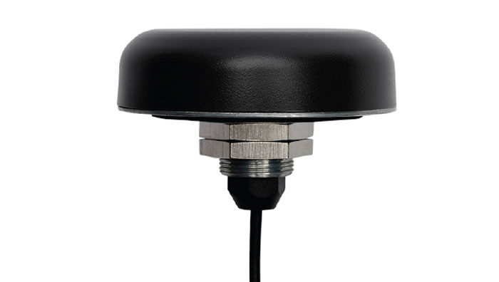
Calian GNSS, formerly Tallysman Wireless, has released its TW5387 industrial-grade smart GNSS antenna. It integrates the Quectel ST TESEO V GNSS receiver chipset onto the Calian compact smart GNSS antenna platform to offer dual-band GNSS, eXtended filtering, low phase center variation, low signal-to-noise ratio and dual feed and patch for strong multi-path rejection.
The TW5387 comes with RTK rover capability and a built-in IMU for sensor fusion. It is designed to minimize RF impairments that affect the performance of the GNSS receiver and provide GNSS coordinates to the host system over a robust digital interface for noise resilience.
TW5387 is suited for automotive, UAV, robotics and defense applications that require precise location and timing. TW5387 is compatible with N-RTK correction services such as Point One Navigation’s Polaris and Swift Navigation’s Skylark.
It tracks GPS, Galileo, BeiDou and L1/L5 band operation and is housed in an industrial-grade IP69K enclosure.
Swift Navigation has partnered with Telit Cinterion to enhance the precision of GNSS positioning in low-power consumption devices such as wearables, robotic lawnmowers and vehicle tracking systems.
Under the collaboration, Telit Cinterion’s GNSS receivers will use Swift’s Skylark precise positioning service, which is designed to deliver consistent precision across vast areas while prioritizing energy efficiency, reducing processing demands and minimizing data transmission costs. It aims to provide accurate location information quickly, even in difficult environments such as urban centers and canyons where signals can be obstructed.
This partnership seeks to enhance location-based applications by allowing these devices to achieve centimeter-level accuracy. This level of accuracy is crucial for the safe operation of autonomous vehicles and industrial robots, but integrating it into small, battery-powered devices has been a complex challenge until now.
The solution is designed to comply with industry standards, making it interoperable with various GNSS chipsets, modules, receivers and applications.
Septentrio, a leader in high-precision GNSS positioning solutions, has launched the Agnostic Corrections Partner Program.
The program facilitates the use of Septentrio receivers with high-accuracy services that provide varying levels of accuracy, coverage and delivery methods. This also allows users to select the service that suits specific applications and business models.
The Agnostic Correction Partner Program, which includes Polaris from Point One, Skylark from Swift Navigation, and PointPerfect from u-blox, provides documentation for the use of Septentrio receivers with these high-accuracy services.
Agnostic GNSS corrections refer to correction services that are not specific to a particular GNSS receiver or device. It provides correction data that can be used by any receiver that can process the correction signal. Agnostic corrections are useful in situations where multiple types of GNSS receivers are being used, such as in a large-scale surveying project or in a fleet of vehicles that use different types of navigation systems.
Swift Navigation has expanded the capabilities of its Skylark precise positioning service to several product tiers. With new services providing real-time kinematic (RTK) and differential GNSS (DGNSS) options, Swift meets the broadening needs of its growing customer base.
In addition, new BeiDou signal support and regional coverage has been added.
Skylark is Swift’s cloud-based GNSS corrections service designed to deliver affordability, high accuracy and fast convergence, eliminating the complexity of deploying and maintaining GNSS networks. The expansion of Skylark’s capabilities makes it possible for customers across industries to benefit from seamless corrections to applications across the globe, the company said.
Skylark RTK delivers Swift’s highest tier of performance to third-party GNSS receivers. Compatible with leading RTK receivers on the market, Skylark RTK delivers corrections for applications that require sub-2 cm accuracy, including agriculture, machine control, drones and robotics in the United States, Europe and select Asian countries.
Skylark DGNSS is suitable for mobile applications, delivering real-time, high-reliability differential GNSS corrections to mobile handsets, positioning engine modules and mass-market applications. Skylark DGNSS enables lane-level location accuracy, in turn enabling new consumer location experiences and improving location-based services to increase efficiency on a global basis.
With BeiDou coverage already available across the United States, Japan and Korea, Swift has now added BeiDou signal support for the European Union, supplementing existing support for Galileo and GPS by providing corrections for GPS L1/L2/L5, Galileo E1/E5b/E5a and BeiDou B1/B2a. In addition, support for BeiDou B1C has been added to all regions.
These additions help support newer mass-market RTK-enabled receivers to achieve high-accuracy performance in difficult GNSS environments and continue to push the envelope for positioning accuracy.
“Swift was founded on the notion of improving GNSS positioning performance for mass-market applications,” said Holger Ippach, executive vice president of product, Swift Navigation . “We are pleased to expand the functionality of Skylark to improve the positioning functionality for many more customers across the globe.”
The suite of Skylark products was built from the ground up for scale, resilience and ease of integration. Skylark delivers seamless corrections to continents and countries across the globe including the United States, Europe, South Korea, Japan, Taiwan and Australia.
Swift Navigation, a San Francisco-based GNSS tech firm, announced that it has completed $100 million in Series D Round financing. The financing round was led by SK Inc. and Potentum Partners with strong support from Swift’s existing investors. Swift’s technology powers several of the largest automotive and commercial vehicle fleets on the road today, supporting enhanced navigation and ADAS.
New investors include FM Capital, OVN Capital, TELUS Ventures, TWM Venture Co., Buckley Ventures, Schox Venture Capital and additional independent investors.
“We are delighted to be the lead investor for this financing transaction as part of our investment strategy in high-tech software companies,” said Subeom Lee of SK Inc. “We believe that Swift will contribute to advancing the new era of driverless technology.”
David Simons, founding partner of Potentum Partners, stated, “Centimeter-level position accuracy on a continent-wide scale is impressive enough, but what really excites us is Swift’s ability to provide it with extraordinary reliability, putting absolute-position data at the core of safety-critical features in automotive, automation and machine control,”
Since its Series C Round of financing, Swift has refined its global, centimeter-accurate precise positioning service and expanded its coverage across continents to meet the needs of an on-demand economy requiring higher levels of autonomy. Swift’s customers span the globe and include automotive OEMs and Tier 1s, last-mile delivery providers, mobile handset and application providers and those building rail, industrial machine control and IoT platforms for mass-market applications.
“We have an amazing group of investors behind us and are honored to see the many customers who are using Swift technology at such incredible scale as they build the future of transportation and automation,” says Swift CEO Timothy Harris. “[We thank] our loyal partners and investors at NEA, Eclipse and EPIQ and […] welcome the support of our new investors to help us deliver precise positioning across the world.”
GNSS receivers face the same old challenges (extremely weak received signal, orbit and satellite clock errors, ionospheric and tropospheric delays, multipath, dilution of precision, urban canyons, etc.) and new ones (increased interference). However, compared with just a few years ago, they benefit from new signals, many more satellites, a panoply of options for corrections, and improved integration with inertial navigation systems (INS).
For example, pole-tilt compensation is quickly becoming standard. This feature enables users to locate dangerous or hard-to-reach points by measuring them at an angle with just the tip of the pole to which the receiver is attached.
Pole-tilt compensation also makes surveying and mapping easier by removing, in many situations, the need to use total stations or offsets. Together with improvements in work processes, this makes GNSS receivers more user friendly. This is particularly welcome now that more surveyors are retiring than there are new surveyors entering the profession.
The greater accuracy of GNSS receivers enabled by the increase in the number and quality of satellites, signals, corrections services and integration of GNSS with other sensors is also increasing the number of use cases, especially at the high end of the accuracy requirements, such as lane-level vehicle navigation. (Next month’s cover story will center on this year’s Google Smartphone Decimeter Challenge contest, in which competing teams aim to bring smartphone location down to the decimeter or even centimeter resolution using raw location measurements from Android smartphones. This could enable services that require lane-level accuracy, such as estimated time of arrival when using a high-occupancy vehicle lane.)
This month’s cover story highlights what has changed “inside the box” to improve the accuracy and resilience of GNSS receivers for surveying, mapping and a variety of other applications. Read the success stories from five different companies below.
An interview with Fergus Noble, CTO at Swift Navigation about recent GNSS receiver innovations.
Noble
What was the most significant technical innovation in your GNSS receivers in the past five years?
At Swift Navigation, our mission has been to bring precise positioning technology to the mass market. We focus on the applications that touch our everyday lives — automotive, transportation, robotics and mobile devices. To realize that mission, we have had to innovate beyond traditional GNSS techniques. There are three areas where Swift has had to push the boundaries of GNSS technology: scalability, affordability and safety.
To meet the scalability needs of applications — such as automotive ones, which require continental-scale coverage for millions of devices — we have had to develop new techniques for providing GNSS corrections. We have developed new algorithms to precisely model the Earth’s atmosphere and other sources of GNSS error over wide areas in real-time and deliver them via scalable state-space representation (SSR) format.
To make the technology affordable, we have partnered with GNSS chipset providers to bring precise positioning performance to vehicles and consumer devices that was previously only achievable using expensive industrial receivers.
Swift brings to vehicles precise positioning that was previously only achievable with expensive industrial receivers. (Photo: metamorworks/iStock/Getty Images Plus/Getty Images)
To make the technology safe, we have developed the most sophisticated end-to-end positioning integrity system available today. This integrity provides our customers with the guarantee of safety needed for autonomous and industrial applications, as well as certifying to industry safety standards such as ISO-26262 (ASIL).
What has it enabled users to do that they could not do before?
Previous precise positioning solutions did not apply to applications such as autonomous driving as they were too costly to go into a vehicle, had the required accuracy only in limited coverage areas, and could not provide the guarantees of integrity such that they could be relied upon as a safety-critical sensor. The same limitations applied to last-mile transportation, consumer robotics — such as lawnmowers — and even mobile applications.
Swift’s technology enables our customers to unlock these use cases by providing reliable and seamless precise positioning to our users at continental scale.
What is a good example of this?
Swift’s technology is now powering one of the largest vehicle fleets on the road today equipped with advanced driver-assistance systems (ADAS). It improves vehicle positioning for an enhanced user experience when navigating, as well as to upgrade the ADAS functionality.
We also have customers using our technology to track and improve safety across a continent-wide rail network, provide precise position to improve the efficiency of last-mile delivery fleets, and a host of other applications across both emerging and traditional GNSS markets.
The companies on June 29 signed a precise-positioning business partnership agreement that KT hopes will enable precision location services for autonomous vehicles, drones and urban air mobility.
Swift Navigation’s precise-positioning platform improves location accuracy from several meters to centimeters, enabling safer driving, improved efficiency for last-mile delivery and commercial transport operations, and enhanced accuracy for mobile devices.
A SolarCleano F1A robot tackles a tough cleaning challenge on a solar farm in Saudi Arabia. (Photo: SolarCleano)
SolarCleano, based in Garnich, Luxembourg, makes robots that clean large solar panel installations using GNSS receivers and corrections from Swift Navigation. We asked Christophe Timmermans, SolarCleano’s managing director, a few questions about its technology.
How often do solar panels need to be cleaned?
For decades, it was believed that solar panels did not need to be cleaned due to their angle to the ground and rain. Nowadays, however, the cleaning of solar panels is widely accepted as necessary to optimize a plant’s return on investment (ROI).
How much time per sq. meter do your machines take to clean solar panels?
To provide the fastest possible ROI to our customers, we developed a range of robots to best address the needs of various solar plant layouts. A large utility-scale project with high level of soiling losses in a desert environment will need a very fast and reactive cleaning solution such as our SolarBridge B1, which can clean 24/7/365 fully autonomously. The most suitable solution for a farm rooftop in Germany that needs to be cleaned three to four times a year might be our F1 model, which can clean the equivalent of up to two soccer fields a day. It is designed for rooftops, floating panels and mid-size plants up to 50 MW. While the speed of cleaning is a very important variable, the quality of cleaning is often considered as the driver to performance, which is why we propose different types of brushes depending on the soiling types. Plus, the robot speed can be modified according to the soiling level.
Why do robots need GNSS receivers to clean solar panels?
Moving on inclined, wet glass surfaces makes odometry unreliable because robots might occasionally slip. Therefore, GNSS is the most reliable way to continuously monitor their exact position. Our robots also need path planning because they cannot operate randomly like lawn mowers. Safety is obviously a major concern; we need a very high localization accuracy to ensure that robots don’t fall off the panels. Finally, the largest solar plants are developed in dry, remote locations with high irradiation such as the Sahara, Atacama and Australian deserts. GNSS allows us to have very accurate localization even in those remote areas. In addition, this solution can easily be installed on already-existing solar plants with little capital expenditure.
What spatial accuracy requirements do the robots have for this task?
Safety is our absolute priority. Therefore, our robots need an accuracy of less than 3 cm. They also need to be aware, in real time, of changes in their surroundings, such as maintenance teams, animals and uneven ground.
On large solar farms, GNSS receivers always have a clear line of sight to the satellites and do not suffer from multipath. So, what are the key technical challenges?
Our robots have the additional advantage that they do not need to drive very fast. However, we need to manage fleets of robots on the other side of the world in regions difficult to access and with harsh weather conditions, such as very high or low temperatures and the accumulation of dust behind panels due to air vortices. We need to be able to perform remote maintenance and solve any issue from our control center in Luxembourg. These challenges make our robots increasingly robust. With a current fleet of more than 300 robots around the world, we collect lessons every day to ensure a greater reliability for our upcoming generations of robots.
Why did you choose to partner with Swift Navigation?
We share a vision with Swift: “Accessible automated solutions serving sustainable goals.” We also share other important values, such as “iterate quickly” and “focus on what matters.”
Partnership to bring integrated precision GNSS solutions to automotive and industrial customers
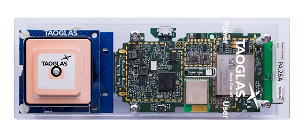
Swift Navigation, a San Francisco-based GNSS firm, and Taoglas, a provider of internet of things (IoT) solutions, have announced a strategic partnership to integrate their technologies to deliver pre-tested, low-risk, high-precision GNSS solutions to a broad customer base.
The Taoglas EDGE RTK Starter Kit has high-precision GNSS with U.S. 4G/3G cellular connectivity. (Photo: Taoglas)
The partnership will provide positioning solutions for automotive, micromobility, delivery, robotic and industrial customers. Specifically, the Taoglas EDGE Locate IoT platform and EDGE RTK Starter Kit now come pre-integrated with Swift’s Skylark precise positioning service.
Bringing pre-integrated, high-accuracy positioning products to these industries in an easy-to-implement solution will greatly improve the accuracy of the positioning data delivered, the companies state.
Together, Swift and Taoglas deliver high-precision GNSS solutions to customers around the globe by utilizing Taoglas’ IoT platforms and Swift’s Skylark seamless, cloud-based corrections — available in advanced SSR (state space representation) or industry-standard formats. The pre-integration allows customers to bypass module-level validation, integration and engineering efforts with an out-of-the-box solution.
“Swift Navigation is excited to begin this partnership with Taoglas and align our visions of making accurate positioning easily accessible across industries,” said Swift CEO Timothy Harris. “We look forward to offering our products as an integrated solution to make it easier for customers across the globe to benefit from affordable and accurate positioning.”
“We are delighted to be partnering with Swift Navigation to enable companies to overcome the challenges of delivering their high-precision positioning-based IoT solutions.,” said Ronan Quinlan, co-founder and joint CEO of Taoglas. “Our worldwide team of design, development, test and manufacturing engineers is dedicated to delivering IoT software and hardware solutions on time, the first time, for leading technology enterprises.”
Additional products will soon be available from Swift, Taoglas and their channel partners. Customers have the ability to pre-order now by contacting [email protected] or [email protected].
Swift Navigation designs, manufactures and integrates GNSS receivers, as well as providing the Skylark wide-area GNSS corrections service. Its markets are automotive, transportation (last mile delivery, commercial trucking, rail), robotics/machine control (construction, mining, precision agriculture, landscaping), UAVs, micromobility and mobile devices and applications.
The company’s technology is compatible and interoperable with most major GNSS receivers for multiple markets. Its Starling positioning engine and Skylark corrections “are scalable to bring precision to legacy low-cost single-frequency receivers, all the way to the most sophisticated state-of-the-art triple-frequency multi-constellation systems,” said Joel Gibson, Swift’s executive vice president of Automotive. “By working with a multitude of receiver vendors for different applications, Swift leverages all constellations and all signals and maximizes the performance required for the application.”
The most accurate and reliable navigation system for every application would take advantage of all available GNSS signals, as well as all available corrections, dead reckoning and fused data from other sensors, such as cameras, lidar and radar. However, of course, that is not possible due to cost, size, weight and power considerations. Swift’s approach to the trade-offs required depends on each use case.
Micromobility
In the area of micromobility (such as scooters), the main constraints for implementing a positioning solution are cost and power, coupled with the challenge of satellite signal outages and multipath in dense urban environments where these vehicles primarily operate, Gibson explained. “Cost-effective dual-frequency GNSS receivers are now showing up in micromobility architectures. Pairing them with our Starling positioning engine, which integrates inertial sensor data and wheel ticks, and augmenting them with Skylark corrections data, makes it possible to meet such compliance requirements as geofencing and limiting sidewalk use.”
Additionally, by achieving decimeter-level positioning, Swift’s micromobility solution makes it easier for both users and service staff to find scooters, which increases the scooter companies’ revenues.
Photo: Swift Navigation
Automotive
In the automotive industry, inertial sensors and wheel odometry are ubiquitous and pair naturally with GNSS to mitigate satellite signal outages, Gibson pointed out. Likewise, cameras and radar — cornerstones of ADAS — are very complementary to GNSS for safety applications, and lidar further complements GNSS in feature-rich environments such as dense urban areas.
Rail
Rail applications, such as Positive Train Control, have traditionally needed an accuracy of one or two meters, coupled with ruggedized hardware. “Swift’s precise positioning solution is deployed across continental rail systems today, and we are now engaging rail OEM and operator programs requiring sub-meter accuracy to ensure track-to-track accuracy and safety requirements in support of the transition to more autonomous rail operations,” said Gibson. “Leading rail companies are also looking for operational efficiencies by transitioning away from the high operational costs of maintaining reference base stations along track routes, instead moving to the more cost effective, reliable and seamless Skylark corrections coverage.”