Tag: Topcon

  • Topcon Partners with Toro on GPS-guided Turf Sprayer

    Topcon Partners with Toro on GPS-guided Turf Sprayer

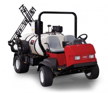
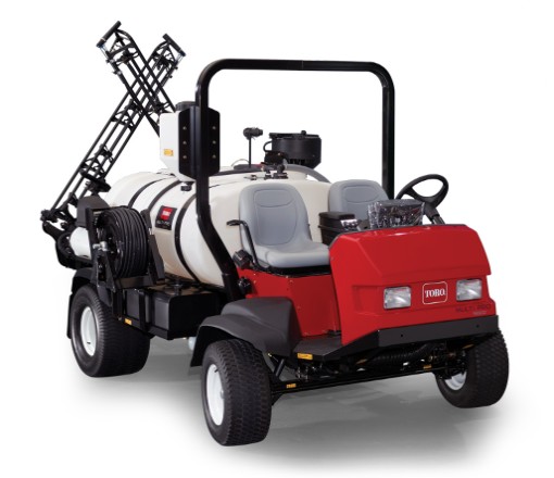
    Topcon Positioning Group is partnering with The Toro Company to develop a GPS-guided sprayer that Toro will start selling to the commercial equipment marketplace this summer. The GeoLink system will be available for the Toro Multi Pro 5800 initially, with plans to offer it for a broader range of Toro sprayers in the future.

    “We’re thrilled to partner with Toro on our debut in the turf spraying marketplace,” said Jason Killpack, director of business development, strategic partnerships for Topcon.

    Source: GPS world staff
    The Toro Multi Pro 5800 sprayer will get Topcon GPS guidance.

    “This new system, which builds upon Topcon innovations developed for precision agriculture, is an excellent example of how positioning technologies can benefit non-traditional industries. We are taking proven precision agriculture technology and providing it as a resource for Toro to employ in its market,” Killpack said.

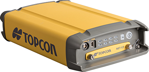
    “In addition to working in tandem with Toro to develop this exciting new product, it also provides us the opportunity to expand our TopNETlive network, which is a key initiative within our organization.” The TopNETlive network is a subscription-based, real-time, GNSS reference network delivering high-quality correction data to rovers used for surveying, construction, GIS mapping and agricultural applications throughout North America.

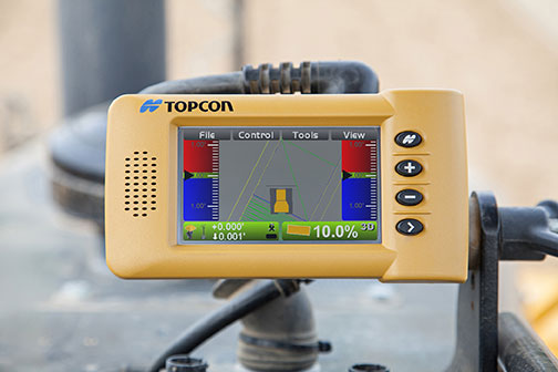
    “We started by understanding customer needs, and then selected Topcon as a partner to develop an integrated user-friendly solution,” said Jace Bertsch, marketing manager for Toro. “We are very excited to offer the unique features that have been engineered into this system, and are confident that GeoLink will be successfully deployed in both the golf and sports field market segments. Simply put, GeoLink ensures accurate and consistent coverage, which translates into exceptional results and reduced chemical costs.”

  • Topcon’s Android App Drives LN-100 Layout Navigator

    MAGNET_Construct_field_Topcon-W

    Topcon Positioning Group has released a new app designed to drive the LN-100 Layout Navigator system MAGNET Construct. The no-cost app, available for the Android market, is built to provide “out-of-the-box” productivity with LN-100W hardware.

    “The MAGNET Construct app offers intuitive options to drive an LN-100W for fast as-built measurements as well as graphical guidance to your design data.” said Oscar Cantú, senior manager of product marketing.

    “When combined with the LN-100W, the app provides an entry-level precise measurement solution for diverse 3D layout applications such as traditional construction, complex landscape layout, architecture, as well as quickly checking existing stakeout locations before proceeding on a project,” said Cantú.

    MAGNET Construct offers optional connectivity with MAGNET Enterprise for real-time data exchange from active project sites to and from the office within a user’s private company account.

    MAGNET_-Construct_Topcon-W“The addition of the new MAGNET Construct app exemplifies our focus to keep the LN-100W productive even with bring-your-own-device (BYOD) scenarios.  Android tablets and smartphones wirelessly driving precise hardware, along with secure connectivity to your office keeps projects productive and profitable,” said Cantú.

    MAGNET Construct is currently available for Android users to download for free on the Google Play store.

  • Topcon, Leica Sponsor REAL 2015 3D Sensor Conference

    REAL 2015: Capture, Compute, Create will be held Feb. 25–26 at Fort Mason Center in San Francisco. REAL is designed to explore the professional 3D sensing, creation, and visualization industries. It includes an executive summit and a world’s fair of cutting-edge 3D demonstrations, and is organized by Autodesk.

    According to organizers, “From drones to autonomous cars, industrial robots to major engineering works, and game consoles to tomorrow’s mobile phones, 3D sensors are suddenly everywhere. And several decades after first grabbing headlines, VR and 3D printing are hot again, attracting billions in investment, and moving beyond early adopters to professionals. But it is the sum total, where sensing meets making, where big change is brewing.”

    Sponsors include Leica Geosystems and Topcon. Two Topcon experts will speak at the event: Jason Hallett, Topcon vice president of global product management, and Eduardo Falcon, executive vice president and general manager of the GeoPositioning Solutions Group.

    “The Topcon line of advanced 3D imaging and mapping technologies are designed for a wide range of geospatial applications providing data-rich results,” Falcon said. “REAL 2015 presents opportunities to explore how our mobile and static scanning solutions can be utilized in forward-thinking ways, as 3D sensing and reality capture continue to permeate traditional and non-traditional industries alike.”


  • Topcon Acquires in-Cab Mounted Console Manufacturer

    Topcon Positioning Group has completed the acquisition of Wachendorff Elektronik GmbH and Wachendorff Electronics Inc. in a private transaction.

    Wachendorff Elektronik GmbH and its U.S. subsidiary Wachendorff Electronics, Inc., are manufacturers of in-cabin mounted consoles for the industrial vehicle market in the agricultural and construction industries.

    “This acquisition is a key ingredient of our global strategy to strengthen our ability to serve original equipment manufacturers (OEM) and establish the foundation for Topcon manufacturing in Europe,” said Ray O’Connor, Topcon Positioning Group president and CEO. “This world-class facility in Germany is second-to-none in its operational quality, employee dedication, and astute leadership — all of the characteristics needed to exceed the high-precision standards required for our industry.”

    “This transaction is an example of our commitment to expand our portfolio of high-quality products and become the world’s leading provider of in-cab consoles for the agricultural and construction OEM markets,” said Albert Zahalka, president of Topcon Precision Agriculture and leader of the acquisition team.

    The Wachendorff family founded Wachendorff Prozesstechnik GmbH & Co KG in Geisenheim, Germany in 1978. Wachendorff Elektronik was founded in 1985.

  • Topcon NET-G5 Tracks New L3 GLONASS Signal

    Topcon's NET-G5 receiver and CR-G5-C antenna.
    Topcon’s NET-G5 receiver and CR-G5-C antenna.

    Topcon Positioning Group said that its latest GNSS reference receiver, the NET-G5, is capable of tracking a new signal from the GLONASS constellation.

    The GLONASS-M 55 satellite was launched in June 2014 and is equipped with the experimental payload capable of transmitting signals in the L3 frequency band. Engineers successfully tracked the signal with the NET-G5 receiver during a series of recent tests at the Topcon Technology Center in Moscow. The use of signals in L3 band alongside L1 and L2 bands is expected to further enhance the competitiveness of the GLONASS system.

    “Topcon is committed to continually investing in research and development to offer end-users and the industry the most up-to-date solutions,” said Ivan Di Federico, chief strategy officer for Topcon Positioning Systems.  “Our premier engineers, scientists and designers bring world’s first products and technologies to market, and the ability of the NET-G5 to track the latest signal — a first for the industry — is an excellent example of that dedication.”

    Using Vanguard and Universal Tracking technologies, the NET-G5 receiver incorporates 452-channels capable of tracking the full GNSS signal spectrum, including modernized GPS, GLONASS, Galileo, BeiDou, QZSS and SBAS signals.

  • Topcon Demonstrates New 3D Positioning System LN-100W at InterGeo

    Topcon Positioning Group demonstrates its LN-100W, an update to its line of 3D positioning systems designed for one-operator layout, while at InterGeo, held October 7-9 in Berlin. The latest model includes Bluetooth functionality.

    See more InterGeo videos at GPS World’s YouTube Channel.

  • Topcon Announces Geodetic Reference Receiver and Antenna

    Topcon's NET-G5 receiver and CR-G5-C antenna. Photo: Topcon
    Topcon’s NET-G5 receiver and CR-G5-C antenna. Photo: Topcon

    Topcon Positioning Group announces the next generation of its geodetic GNSS reference receivers and antennas — the NET-G5 receiver and CR-G5-C antenna.

    The announcement was made at InterGeo 2014, being held this week in Berlin.

    Using Vanguard and Universal Tracking technologies, the NET-G5 receiver incorporates 452 channels capable of tracking the full GNSS signal spectrum, including modernized GPS, GLONASS, Galileo, Beidou, QZSS and SBAS signals. Universal Tracking has the advantage and capability to assign any visible GNSS signal to any available receiver channel.

    The NET-G5 receiver is designed to work as a complete system connectivity solution, with built-in Bluetooth and Wi-Fi, for flexible wireless communications or via standard Ethernet, serial and USB connections. Other features include: High-precision code and carrier phase measurements up to 100 Hz; Power over Ethernet (PoE) and an all new Topcon receiver web interface with advanced receiver management features.

    “Comprehensive communication support, advanced web-server capability, and extended operating times are among the new features supported on the NET-G5. Coupled with the CR-G5-C antenna, the new systems provides a powerful, interference protected network solution,” said Charles Rihner, vice president of the Topcon GeoPositioning Group.

    “Whether you are installing an all-new GNSS network infrastructure, expanding or upgrading an existing network, looking for a premium campaign receiver or stand-alone RTK base station, the high-performance NET-G5 is designed to provide the most advanced reference station solution available in the market,” Rihner said.

    The CR-G5-C is a full-wave geodetic choke-ring antenna designed to address evolving requirements for reference networks and infrastructure monitoring applications. “The CR-G5 antenna has excellent vertical phase center stability over the entire GNSS frequency band, providing superior performance in tracking low elevation satellite signals,” Rihner said. “This new model employs cavity filter technology to more aggressively combat radio frequency interference in difficult environments.”

  • Topcon Announces Latest Addition to 3D Layout Line

    Topcon's LN-100W 3D positioning system.
    Topcon’s LN-100W 3D positioning system.

    Topcon Positioning Group announces an update to its world’s first line of 3D positioning systems designed for one-operator layout — the LN-100W.  The latest model includes Bluetooth functionality.

    The LN-100W is on display at InterGeo 2014, being held this week in Berlin.

    “LN-100W offers an enhanced level of connectivity with the addition of Bluetooth functionality,” said Ray Kerwin, Topcon director of global surveying products. “Now operators have an additional wireless communication option that will provide greater versatility with devices such as tablets that might not be WLAN ready.

    “The update exemplifies our focus on making the LN-100 as simple to use as possible,” said Kerwin.  “The LN-100W offers the popular self-leveling, one-operator 3D layout features of the original model, and takes the ease-of-use a step further.”

    The LN-100W is the newest of BIM (Building Information Modeling) solutions from Topcon.

    Watch a video demonstration from InterGeo below.

  • Topcon and MAVinci Announce Sirius Pro for Use with RTK Base Stations or NTRIP

    Topcon Positioning Group and MAVinci GmbH have released the latest version of the Sirius Pro surveying UAS (Unmanned Aerial System) program, designed to be compatible with existing RTK (real-time kinematic) base stations or NTRIP (network transport of RTCM data over IP).

    “By connecting an external base station, Sirius Pro will receive the RTCM correction signals and deliver 2-5 centimeter accuracy without using ground control points,” said Eduardo Falcon, executive vice president and general manager for the Topcon GeoPositioning Solutions Group. “When you have mobile Internet on your site, you can achieve the same accuracy even without a local base station using NTRIP.”

    Sirius Pro is designed to deliver orthofotos and three-dimensional elevation models with a high absolute accuracy of 2-5 centimeters without using ground control points. “Combining MAVinci‘s precision timing technology with Topcon sub-centimeter grade L1/L2 GPS/GLONASS RTK receivers, this robust system stands up with a clever solution that helps in the realizing of projects in a better and faster way,” said Johanna Claussen, CEO at MAVinci.

    For users who do not have an RTK base station, an internal base station add-on for the Sirius Pro is available. “It upgrades the Sirius Pro to its full functionality: Use of an internal or external base station depending on your needs,” Claussen said. “This add-on is available anytime via Internet without changing your hardware.”

    Sirius Basic is an entry-level solution for UAS surveying, and delivers orthofotos and 3-D elevation models. The system is designed to offer high-accuracy when using ground control points. “Sirius Basic offers you full flexibility,” said Falcon. “It can be upgraded to Sirius Pro via an Internet update later on — no hardware change is necessary.”

    The system will be available at the Intergeo trade show for geodesy in October and thereon.  The Topcon and MAVinci UAS was first introduced at Intergeo 2013 for the European market and was recently made available in the North American market.

  • Topcon GPS Tech Used to Create National Mall ‘Facescape’

    Topcon GPS Tech Used to Create National Mall ‘Facescape’

    Topcon Positioning Group’s technology and assistance will be used to create a large-scale landscape portrait planned for the National Mall.

    Artist Jorge Rodríguez-Gerada has been commissioned by the Smithsonian’s National Portrait Gallery to create a six-acre portrait that will be a composite of several different faces. The project, titled “Out of Many, One,” will use high-precision GPS survey technology from Topcon to create the “facescape” between the World War II and Lincoln memorials along the south side of the Reflecting Pool. The portrait will be viewable from atop the Washington Monument.

    The facescape will be built along the Reflecting Pool on the National Mall.
    The facescape will be built along the Reflecting Pool on the National Mall.

    Topcon is providing equipment and personnel to help create the portrait. “Topcon GPS technology is my paintbrush,” Rodríguez-Gerada said. “This facescape would not be possible without the highly precise GPS and hybrid positioning equipment, as well as the technological expertise contributed by Topcon.”

    “In a sense it is reverse surveying,” said Mark Contino, Topcon vice president of global marketing.  “Surveyors normally measure the real world and scale it down to readable maps. In this case, the project starts in the artist’s mind and each contour of his drawing will be redrawn in the field using stakes guided by Topcon GPS technology and MAGNET Field software.”

    The GPS positioning portion of the project will begin the week of September 15, and the final portrait is expected to be completed for unveiling in October.

  • Topcon Releases New UAS for Aerial Mapping

    Topcon Releases New UAS for Aerial Mapping

    Sirius-Topcon-UAS-O

    Topcon Positioning Group has released two unmanned aerial systems (UAS) for mapping — the Sirius Pro and Sirius Basic. Both systems are designed to produce the most accurate solutions for the automated mapping of a wide range of sites — regardless of terrain — including construction sites, mines and quarries, and for use in land surveying, power line and pipeline inspection as well as precision agriculture field mapping.

    The fixed-wing systems resulted from a partnership with MAVinci GmbH, a UAS development company with which Topcon recently entered into a worldwide distribution agreement.

    “The Sirius Pro system is unique to the UAS marketplace. Instead of using traditional ground control points, Topcon combines RTK (real-time kinematic) GNSS solutions with precision timing technology to provide more accurate mapping results when compared to other products,” said Eduardo Falcon, executive vice president and general manager for the Topcon GeoPositioning Solutions Group.

    “The system is easy to use and rugged — allowing operators to use a simple hand launch with precise automatic operation from takeoff to landing, and it can be flown safely in nearly all weather conditions,” Falcon said.

    The Topcon Sirius Basic is an entry-level system offering many of the advantages of the Sirius Pro with options to upgrade. “The Sirius Basic shares the same hardware components of the Pro model, providing affordability with the same level of sturdiness and ease of operation,” said Falcon. “Additionally, when the need arises for the increased accuracy and productivity of the Pro system, a simple upgrade makes the transition practically effortless.”

    Both systems also offer autopilot assisted manual control, automatic flight planning and safety features.

  • Topcon Offers 3D Indicate Grade System

    Topcon Offers 3D Indicate Grade System

    I-33_Topcon-WTopcon Positioning Group has announced a multi-platform 3D indicate grade system, the i-33. The new system features GNSS technology and a graphical display designed to provide a powerful indicate system at an economical price.

    The i-33 allows for quick installation and easy operation on many types of grading and earth-moving machinery, according to Topcon. It is designed for use on a dozer, scraper or any type of machinery used for cut or fill operations.

    “The new system brings the productivity of GNSS-based 3D grade control for all types of applications,” said Kris Maas, Topcon’s manager of machine control product marketing.

    “Indicate GNSS systems have not been an economical reality for many contractors or types of work. In other words, the return on investment for a traditional 3D-MC system did not make it practical for bulk earthmoving or less utilized equipment,” Maas said. “With i-33, the game has changed. Its low cost and quick installation make it the perfect solution for use on multiple pieces of equipment or even sharing between machines. Basically, it eliminates over- or under-cutting and ensures material is moved exactly where it needs to be the first time.”

    The GX-30 graphical display control box keeps the operator “visually informed as to final grade so adjustments can easily be made, eliminating redundant passes and helping to further reduce the need for onsite grade checking,” Maas said.

    The system also includes the new MC-i3 GNSS receiver with Vanguard technology, offering single or dual GNSS antenna configurations, allowing the system to work in a wide variety of applications. The MC-i3 also allows connection to Topcon’s Sitelink3D site management solution that provides real-time data control, machine tracking, reporting and planning in one solution to maintain conformance and improve productivity through all job phases.