Topcon Positioning Group has added the FC-5000 to its line of data controllers for construction and surveying professionals. The 7-inch sunlight-readable display field controller is designed to provide operators a larger, more versatile and faster handheld computer for the modern construction site.
“At 7-inches, the FC-5000 has the largest handheld data controller screen in our product line,” said Ray Kerwin, director of global surveying products. “The display has a capacitive touch interface — with finger, glove, small tip stylus and water capable options — that is optically bonded to increase visibility. With the press of a key, a user can change the orientation of the screen from portrait to landscape to increase visibility when viewing maps or drawings.”
The controller is compatible with all Topcon GNSS receivers and total stations — operating MAGNET Field, Site and Layout software.
“The FC-5000 comes with two built-in cameras — an 8 MP camera with autofocus and LED flash for field photography — and a 2 MP camera on the front for video meetings. With 64GB of flash storage, users can store hundreds of photos in the unit, which can be easily transferred to any computer or USB stick,” Kerwin said.
Additional features include an optional 4G LTE cellular modem, internal GPS navigation, Bluetooth and Wi-Fi, and a battery life of 10-plus hours.
Topcon Positioning Group has released a new excavator system with local positioning system (LPS) capabilities. The X-53i LPS is designed to provide a solution for machine-controlled excavation in sky-obstructed areas.
“The system is perfect for projects such as tunnel construction or working within existing structures using a total station and prism for precision,” said Kris Mass, director of construction product management. “It’s also versatile when GNSS positioning is available with the new Topcon MC-i4 receiver. Operators can easily choose which type of sensor to best use for the project.”
The system is compatible with the new Topcon GX-55 control box — a large sunlight-viewable LCD touchscreen with integrated LED light bars designed for continuous grade reference of the bucket’s teeth. “It’s the finest graphical experience for modern machine control with customizable audible tones, all wrapped up in a lightweight package for easy transfer and storage,” Maas said.
Topcon Positioning Group has released the latest addition to its line of compact digital laser sensors — the LS-100D. The sensor digitally displays the offset value to on-grade, which is designed to help make elevation and vertical alignment control easier and faster for any application.
“The LS-100D features an extra-wide beam capture sensor that also rejects annoying interference from strobe-light exposures,” said Kris Maas, director of construction product management. “The large and bright LCD displays (front and back) feature nine channels of grade information and digitally display the distance to on-grade. By pressing the hold button, the display is locked so the user can conveniently read the results.”
The sensor offers three colored LED’s and a magnet mount for vertical operation, which is designed to be useful for steel erection or operator grade-checking while excavating. Alert icons appear on the LCD if the accompanying Topcon rotating laser instrument is disturbed (HI alert) or when the laser battery is low.
Topcon Positioning Group has released the latest addition to its ES total station series, the ES-50. Featuring advanced reflectorless capabilities, the new ES-50 is designed to provide an entry-level total station option with a fast and powerful electronic distance meter (EDM).
“With the functionality of many high-end robotic total stations, our ES series is known to be full-featured and ready to tackle modern job sites,” said Ray Kerwin, director of global surveying products. “The ES-50 incorporates all those time-honored expectations, along with a reflectorless EDM of up to 350 meters, and 4,000 meters with the use of a prism.”
The ES-50 offers 2- and 5-arc second accuracies for distance measurements in projects such as land surveying, topography and as-built, construction and layout, or foundation and exterior job sites.
Additional features include a battery life of up to 15 hours, dual-axis compensation, a waterproof design and a laser pointer.
Topcon Positioning Group has released an indicate dozer machine control system — the i-53. The new system comes with the latest Topcon GNSS receiver, a graphical user interface and machine-control software designed to deliver a versatile indicate dozer system at an economical price.
The system expands the Topcon dozer indicate product line by offering a single-GNSS-plus-slope sensor designed for complete control of elevation and slope.
“The i-53 features the Topcon GX-55 control box with audible grade reference alarms and visual LED lights, as well as the new MC-i4 GNSS receiver,” said Kris Maas, director of construction product management. “With safety and work efficiency in mind, the bright screen and grade guidance features deliver the highest quality graphical experience for modern machine control.
“The communication of the machine is handled by the innovative MC-i4 GNSS receiver that allows various radio configurations in one receiver for the Sitelink3D site management solution and/or network corrections,” Maas said.
“Topcon continually strives to provide the greatest value indicate systems in the market. Now by utilizing slope sensors in an indicate system — we are able to greatly improve the blade’s cutting edge position and angle — which advances the grading capabilities of the dozer,” Maas said.
Additional features include integrated virus protection and easy-access USB ports for saving and downloading job files.
Topcon Positioning Group has acquired a significant share of holdings a company that assists customers in virtual design and construction (VDC).
Viasys VDC — based in Espoo, Finland — has developed a suite of tools and services to assist customers in building virtual models for infrastructure and site-work projects. Using building information modeling (BIM) technologies, its solutions create VDC models that optimize the construction process throughout the project’s lifecycle, creating enhanced quality, higher efficiencies and reduced costs, Topcon said.
“Viasys VDC solutions allow for the import of virtually any BIM or non-BIM design model, offering seamless interoperability with open design standards currently in the market — which provides the contractor or engineer with full control and visibility of the entire design throughout the entire project,” said Heikki Halttula, CEO and president, Viasys VDC Ltd. “With advanced simulation tools and communication functions, design-build issues can be detected before actual work starts, or at any time during the process.”
Accurate 5D simulation allows for optimal planning and execution, Topcon said in a news release. Other significant features include cloud-based collaboration functions as well as mobile access to models and information on-site.
Topcon currently offers various BIM and remote site management/visibility solutions aimed at many of the markets served by Viasys VDC.
“Now, with our investment in Viasys VDC, we have partnered with the technology leader to allow us to offer an expanded platform for the future generation of advanced Topcon VDC solutions with seamless BIM interoperability for our partners and customers,” said Ewout Korpershoek, Topcon executive vice president for mergers and acquisitions.
“Partnering with Topcon is an exciting step forward to help advance our industry-leading VDC solutions, while also expanding their reach to a global audience,” Halttula said. “With Viasys VDC offices in Finland, California and Vietnam, we are also well positioned geographically to work directly with existing Topcon operations in Europe, North America and Asia.”
In addition to a full suite of BIM-based mobile workforce solutions, Viasys VDC offers an operational asset management solution as a basis for lifetime maintenance of the VDC managed projects.
Topcon Positioning Group’s DS-200i direct-aiming motorized imaging station is now compatible with the new Autodesk BIM 360 Layout app for the Apple iPad.
The DS-200i is the second total station solution that Autodesk and Topcon have collaborated on for contractors, following the Topcon LN-100 Layout Navigator.
The DS-200i has an electronic distance measurement (EDM) range of up to 1,000 meters (3,280 feet) without the need of a prism, and 5,000 meters (26,240 feet) with one. The built-in wireless WLAN connects the iPad with the BIM (building information modeling) 360 Layout app.
The collaboration provides contractors the ability to connect a coordinated model to the field layout process, helping to increase job-site productivity while improving the accuracy of staked or installed building components, according to a Topcon news release.
Additionally, the DS-200i offers an excellent reflectorless solution for quality assurance and quality control workflows — verifying items in the field are installed correctly as compared to models.
The DS-200i features real-time video imaging with a 5 MP camera. The controller’s touchscreen video and arrow keys are designed to let remote operators view what is being measured, Topcon said, similar to looking through the telescope.
The Autodesk BIM 360 Layout app is available through the Apple App Store.
Topcon Positioning Group announces a new partnership with digital photogrammetric solution provider Agisoft LLC. The agreement is designed to further expand the Topcon solutions portfolio for mass data collection (MDC).
Agisoft is a world leader in the processing of digital imagery in order to generate high-accuracy 3D spatial data using photogrammetric and computer vision techniques, and has been developing imaging solutions for nearly 10 years. Topcon will provide the Agisoft Photogrammetric Kit for Topcon — Professional Edition software for post-processing of data collected using the Falcon 8 and Sirius Pro unmanned aerial systems (UAS).
Features include photogrammetric triangulation, dense point-cloud editing and classification, digital terrain or surface model export to a variety of formats including georeferenced orthomosiac production (including GeoTIFF and KML export), multi-spectral imagery processing, 3D model generation and texturing, as well as full measurement analysis tools.
“We are very excited to be able to offer the combination of our Sirius Pro and Falcon 8 UAS devices and Agisoft Photogrammetric Kit Professional software. The solution provides an integrated workflow for reaching high-accuracy survey results using unmanned aerial systems with minimal field work,” said Eduardo Falcon, executive vice president and general manager for the Topcon GeoPositioning Solutions Group. “For example, when using the Sirius Pro, absolute accuracies down to 1.6 cm (0.6 in.) in plan and 2.7 cm (1 in.) in height are possible without the need for any ground control.”
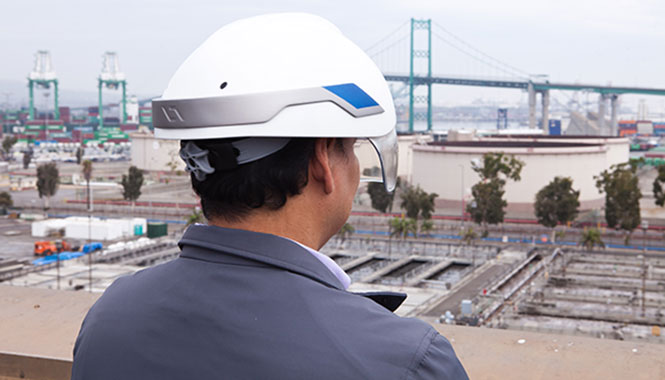
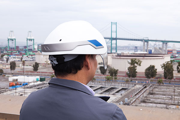
Topcon Positioning Group is collaborating with DAQRI, an augmented reality company, on wearable technology designed to change the way construction and survey professionals interface with the job site.
DAQRI is the creator of the DAQRI Smart Helmet, an industrial-grade wearable that seamlessly connects humans to their work environments by providing information about the world around them.
Topcon and DAQRI will work together to create a solution designed to make workers on the job safer and more productive through the use of augmented reality technologies. They plan to do this by integrating DAQRI’s hardware and software solutions with Topcon positioning solutions.
The DAQRI Smart Helmet was designed for the industrial workplace. It includes an advanced sensor package, an intuitive user interface that requires zero calibration, and a battery that lasts a full shift.
Powered by 4D Studio, DAQRI’s software platform for positioning, the partnership will allow construction workers to view information from their projects in the real-world work environment to make their workflows safer and more efficient.
The collaboration is designed to bring wearable technology to a wider AEC (architecture, engineering and construction) user base, empowering the wearer with a hands-free tool that can be used on the job, Topcon said in a news release.
“DAQRI is a leader in providing solutions in outdoor environments, which will meld well with our positioning and software innovations,” said Jason Hallett, Topcon vice president of product management. “It’s the first step in utilizing our mutual synergies to develop rugged, heads-up display technology for our marketplace.”
“We are committed to developing innovative solutions that power the future of work and Topcon is at the forefront of the industry with some of the most innovative products that are being used by millions of workers across a variety of environments,” said Matt Kammerait, vice president of product, DAQRI. “This makes them the perfect partner to integrate the Smart Helmet into existing workflows. We look forward to seeing how our partnership re-defines the nature of ‘work,’ by setting a new standard for wearables in the AEC space.”
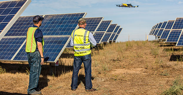
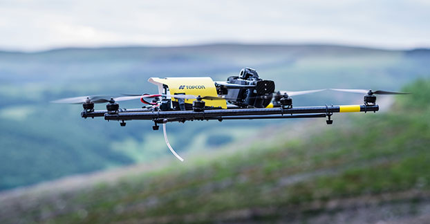
The Topcon Falcon 8 — powered by Ascending Technologies — is designed for inspection and monitoring, as well as survey and mapping applications.
“Along with our exemption for the Sirius fixed-wing system, the Falcon 8 exemption extends the Topcon UAS presence in the rotary-wing solutions market to be an even more powerful resource and provide demonstrations and training,” said Eduardo Falcon, executive vice president and general manager of the Topcon GeoPositioning Solutions Group. “Aerial data collection has a strong future in all the industries we serve, and the possibilities for survey, construction, agricultural, and emerging inspection applications are seemingly limitless.
“Building on the success the Falcon 8 has already seen in Europe, this exemption allows Topcon to expand on that momentum in the U.S. market,” said Falcon.
Topcon Positioning Group has added a rotary-wing unmanned aerial system (UAS) to its mass data-collection solutions line. The Falcon 8 — powered by Ascending Technologies — is designed for inspection and monitoring, as well as survey and mapping applications.
“Rotary-wing systems provide the perfect solutions for small-scale sites and projects for which flexibility of takeoff and landing or an oblique perspective is required,” said Charles Rihner, vice president of the Topcon GeoPositioning Solutions Group. “The Falcon 8 offers the flexibility to maneuver in small spaces and can cope with challenging environments often presented in inspection and monitoring. It is also well suited for smaller mapping or modeling projects up to 85 acres that require high-resolution imaging.”
The Falcon 8 features new AscTec Trinity technology, an autopilot safety feature that provides three levels of redundancy for protection against performance drop or loss of control. Three IMUs (inertial measurement system) synchronize all sensing data and identify, signal and compensate when needed.
Two models are available — the GeoEXPERT for surveying, modeling and mapping projects, and InspectionPRO for industrial inspection and monitoring applications. The GeoEXPERT includes a HD RGB camera payload, while the InspectionPRO features an HD RGB camera and infrared sensor combination.
“Both versions offer easy deployment and operation with real-time video and data monitoring capability, navigation software for planning and optimizing flights, as well as photo-tagging and desktop software to quickly generate high-quality and easy-to-edit material,” said Rihner.
The Falcon 8 complements the Topcon Sirius Pro fixed-wing UAS, providing large area accurate mapping without the requirement for traditional ground control.
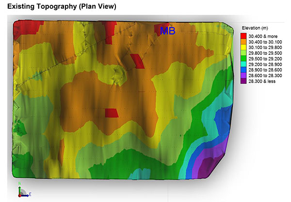
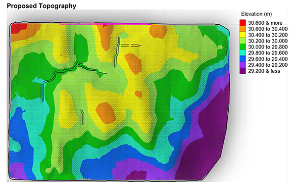
GPS landforming is the reshaping of a fields topography to predesigned 3D surfaces using high-accuracy GPS to control the blade height of the earth-moving machine. It is typically done to improve surface drainage and water infiltration uniformity.
Davco Optisurface, the company that developed the 3D landform design software OptiSurface Designer, has seen strong adoption as the concept catches on. The software has been used to design more than 400,000 acres, according to Arkansas-based global sales manager Preston Marthey.
WM-Form. Trimble launched a GPS landforming software program in February. WM-Form enables growers and contractors to turn their fields into optimal surfaces, even in areas that could not be leveled before, Trimble said.
“With more farmable land that is optimized for water management and more uniform production, growers can experience increased yield,” said David Fitzpatrick, Water Solutions business area director for Trimble’s Agriculture Division.
Trimble’s product is designed to work with its WM-Topo survey system and Trimble FieldLevel II system. WM-Form has surface design tools and flexible parameters so growers and earthworks contractors can use it to repair underperforming areas and extend the amount of productive farmable land. It can reduce the volume and cost of earthworks and minimize disturbance to valuable topsoil. Growers can optimize water distribution and drainage, reduce erosion and flooding by effectively directing waterflow, and create more uniform crop production that can lead to increased yield.
Growers can analyze topographic data in WM-Form to identify surface problems limiting yield potential and create a design that optimizes their field’s surface. The software also provides reports for volume, area and constraints, providing an accurate quote on the total cost of the project.
Horizon. Topcon’s Horizon software is an icon-based, user-definable system that presents a choice of views for each function you perform. It runs on all three of Topcon’s X family of precision agriculture consoles. With Horizon, growers can set autosteering patterns, control application rates, monitor operations, and map every pass — and a new feature allows for water management.
“Water conservation…is designed to provide the ability to perform land forming while also offering GNSS auto steering of the tractor,” said Neal Toso of Topcon Positioning. Using the Topcon X30 and AGI-4, water conservation and land forming users can level fields while auto-steering to maximize efficiency and reduce the amount of material moved, he said.
“With the X30 console, using Horizon software, connected to Topcon MC-R3 blade control, it is easy to take the output from Topcon AGForm 3D design software to produce accurate modeling and land forming. This allows proper drainage to occur, resulting in a healthy, productive crop,” said Toso. “Together, these Topcon products are designed to provide a turnkey approach to superior landforming operations.”
In Costa Rica, Jose Maria Aguero, CEO-director general of Agricultura Cientifica S.A., now uses Horizon. Aguero first employed laser leveling in the late 1970s. “We started noticing that rice and other crops produced less in areas with deep cuts from laser leveling because we had cut the more fertile topsoil off,” Aguero said. “But it was the only tool we had, so we kept doing it.”
Then Aguero discovered Topcon’s GPS land forming products. “Sugar cane crops are expanding dramatically in our area, and the operators don’t use irrigation. Water management is needed to improve drainage because in the rainy season it is too wet, which affects crop development. The only way the cane companies can get sugar cane into a new growing area is with GPS and 3D landforming,” he said.
“GPS with 3D landforming only moves 250 to 300 cubic meters per hectare,” Aguero said. Compared to laser leveling, “That is more than a 90 percent reduction in cost. And, moving less soil keeps more of the fertile top layer in place to promote fertility.”
Landforming Lessons
Surface drainage and irrigation problems can be solved with GPS landforming at low cost, agricultural engineer Graeme Cox says. This is proven with many crops and farming styles, irrigated and non-irrigated.
Cox has learned the following about GPS landforming, based on his experience around the world.
Water is king. Eighty percent of yield variability and profit loss is due to too much, or too little, water. Yield maps show this. “Focus on optimizing water management first,” Cox said.
Ponding kills profits. If water is standing in fields 24 hours after rainfall or irrigation, it is killing profits. “Expect eight percent per day yield loss plus nitrogen loss, increasing pest and disease, delaying planting, spraying and harvesting.”
Subsurface tile drainage is good, but expensive. “Tiling typically has a lower return on investment than GPS landforming and does not work well on heavy soils or those with limited elevation relief,” Cox said.
Ditching is good. “But,” he adds, “it can be a pain if ditches take out valuable crop area or restrict machinery access.”
Lasers are dead. Lasers only work in a straight plane. GPS allows farmers to follow curved topography with curved design surfaces.
Earthworks and topsoil movement can be reduced up to 80 percent with landforming designs and GPS machine control compared to other methods, Cox claims.