RoGO Communications, the creator of the DropBlock satellite communications platform for cellular-denied environments, is partnering with Augmented Sense Technologies (AugSense) to integrate artificial intelligence capabilities into RoGO’s communications infrastructure.
RoGO was founded to develop lifesaving technology for wildland firefighters and first responders. It’s product DropBlock is a ruggedized, portable satellite communications platform that provides real-time GPS tracking, weather telemetry, IoT sensor data, and tactical messaging in cellular-denied and remote environments.
The partnership will develop edge AI-powered sensor fusion, Team Awareness Kit (TAK) ecosystem development, and predictive analytics to firefighters, disaster recovery, military and other first responders and remote operators, including All Hazards emergencies such as hurricanes, earthquakes and floods. Last month, RoGO and AugSense presented the combined capabilities at the annual convention for Special Operation Forces (SOF Week) in Tampa.
Wildland firefighters, search-and-rescue teams, and military personnel routinely operate in remote terrain where conventional communications infrastructure does not exist. RoGO’s DropBlock technology has proven its ability to deliver real-time GPS tracking, weather data, IoT sensor telemetry, and tactical messaging over satellite links in these environments—deployed today by wildland fire agencies. As missions grow more complex and sensor-rich, operators increasingly need more than raw data. AI can deliver intelligence at the edge, delivered in real time, without dependence on connectivity.
Through this partnership, RoGO will enhance its platform with AugSense’s edge AI engine, a modular, platform-agnostic system that processes and fuses multi-modal sensor data directly on devices, without requiring a cloud connection. The AI-enriched intelligence products will transform raw sensor feeds into actionable decisions, such as predictions for the spread of a wildfire or other threats to safety.
Edge AI Capabilities
Edge AI Processing: AugSense’s engine runs AI workloads directly on edge devices using neuromorphic and spiking neural network architectures, achieving greater energy efficiency than conventional approaches. This means intelligence processing in power-constrained environments — no cloud, no data center, no latency.
Multi-Modal Sensor Fusion: AugSense’s fusion engine synthesizes data from diverse sensors (RF, weather, geospatial, physiological, and chemical/biological) into a single actionable intelligence picture at the edge.
TAK Integration & Development: Purpose-built plugins for the Android Team Awareness Kit (ATAK) and broader TAK ecosystem that overlay AI-fused intelligence onto the common operating picture, enhancing coordination across distributed teams connected through RoGO’s DropBlock network.
Predictive Analytics: Machine learning models that transform raw sensor telemetry into forward-looking predictions such as anticipating weather shifts, equipment failures, threat patterns, and fire behavior.
Immediate Applications
The combined solution targets several high-impact use cases.
In wildland firefighting, the integration enables AI-predicted wind shifts and fire behavior models to reach incident commanders via RoGO’s satellite network—critical for crew safety decisions.
For search-and-rescue operations, fused sensor data and intelligent mapping overlays allow distributed teams to coordinate effectively through the DropBlock network without relying on cellular infrastructure.
In defense and special operations, the partnership delivers fused multi-sensor intelligence and TAK-integrated common operating pictures over satellite backhaul in contested and communications-degraded environments.
A new RoGO mobile phone app coming in the third quarter enables point-to-point communications among DropBlocks and firefighter crews and displays the location of firefighting assets along with fire weather data.
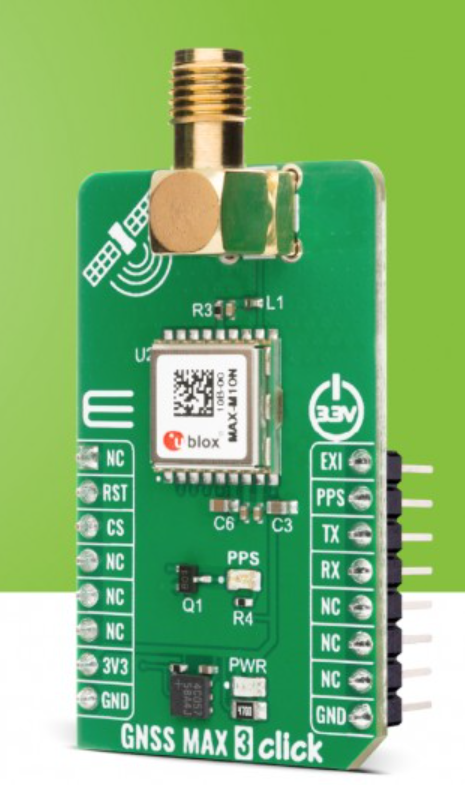
A new GNSS board is available from Mikroe. The GNSS MAX 3 Click is a compact add-on board designed for low-power satellite positioning for embedded applications. It is based on the MAX-M10N-10B, a professional-grade standard-precision GNSS receiver from u-blox, built on the ultra-low-power u-blox M10 platform.
Key Features
Multi-Constellation GNSS. Offers exceptional tracking capability across GPS, Galileo, BeiDou, and QZSS/SBAS systems for reliable global coverage
Ultra-low power. Uses the u-blox M10 platform and the LEAP (Low Energy Acquisition and Processing) energy-saving mode for extended battery life
Enhanced RF immunity. Features an additional SAW (Surface Acoustic Wave) filter for excellent performance in the presence of strong RF interference
Interference detection. Includes integrated jamming and spoofing detection for robust security and reliable operation
Fast acquisition. Supports AssistNow Predictive and Live Orbits for faster satellite acquisition (time-to-first-fix)
Standard precision. Provides consistent L1 GNSS performance at a standard precision level.
Applications
Asset tracking devices and logistics solutions requiring long battery life and accurate location data
Portable devices and wearables where power efficiency is critical
Industrial monitoring and sensor applications requiring reliable, interference-resilient positioning
Any application demanding interference-resilient GNSS positioning.
EmbeddedWiki
Hundreds of ready-to-use embedded projects featuring this Click board are available on EmbeddedWiki.
Norbit’s Connectivity segment has received a new order for deliveries of GNSS on-board units to the European Electronic Toll Service (EETS) provider Toll4Europe. Norbit, based in Trondheim, Norway, is a global provider of tailored technology to selected applications. Its Connectivity segment provides tailored wireless solutions for identification, monitoring and tracking.
Deliveries of the GNSS units are scheduled for first half of 2026. The total order is estimated at 160 million kroner.
“We are proud to be given the trust from Europe’s leading tolling service provider,” said Per Jørgen Weisethaunet, CEO of Norbit. “This repeat order demonstrates the strength of our ability to deliver tailored technology and our strategy to act as a technology partner for our client.”
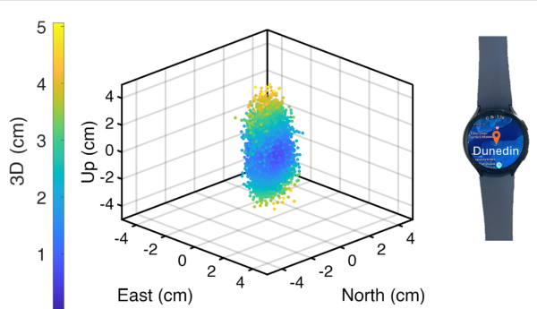
University of Otago – Ōtākou Whakaihu Waka researchers have developed algorithms that improve the precision of location tracking in smartwatches.
Led by Associate Professor Robert Odolinski, a visiting researcher with Google from Otago’s School of Surveying, the research team demonstrated that a smartwatch determined its location with centimeter-level precision over four hours with a stationary setup. The result was achieved by using the Google GnssLogger app and combining precise signals from several GNSSs.
The research was done in collaboration with Google’s Android Context group and the Chinese Academy of Sciences. Results are published in the scientific journal GPS Solutions.
For decades, achieving centimeter-level positioning has required industries such as surveying, construction and engineering to invest in expensive GPS equipment.
“While the use of the so-called carrier-phase signals has long been known to improve the positioning performance, the specialized antenna and receivers needed for this have traditionally come at a cost far beyond the reach of many who would benefit from the technology. This is just the beginning of what wearable high-precision positioning can potentially achieve.”
GPS was introduced in a wearable watch in 1999, but hardware and power consumption limitations prevented it from tracking the carrier-phase signals needed for high-precision results. Recent advances in smartwatches now make this possible.
Precise centimeter-level positioning on a smartwatch during 4 hours of data in Dunedin, New Zealand. The dots show the repeatability of one second of data in comparison to precise benchmark coordinates. The repeatability of the positioning is about 8 cm, at most twice as large as the smartwatch diameter of 4 cm (displayed to scale).
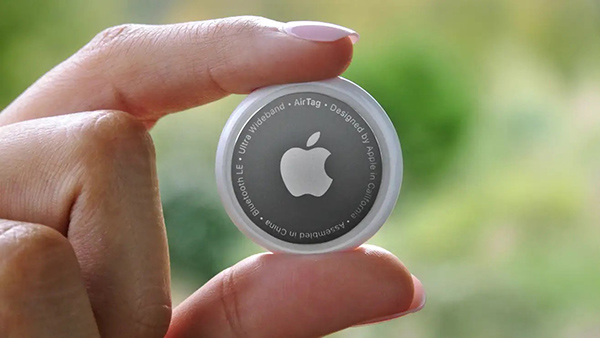
Two women have filed a class-action lawsuit against Apple for privacy concerns as Apple AirTags are being widely used for malicious and criminal purposes.
Both women and their families were tracked and stalked by ex-partners using Apple AirTags hidden in their personal belongings. They are now suing Apple for negligence and privacy violations stating the company failed to protect its customers. They are both seeking damages and are hoping to prevent Apple from continuing to manufacture this product with “design flaws.”
The location device was designed by Apple in 2021 and its intent is to be attached to such items as keys, suitcases and purses to make them trackable. However, the $29 Bluetooth-enabled AirTags can be used as a weapon by abusers, stalkers and traffickers to easily find and track their victims.
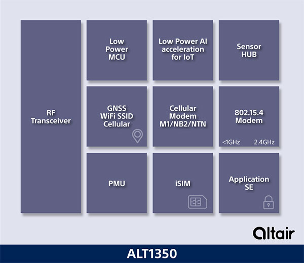
Innovative chip offers multiple ultra-low power connectivity options and low-power processing for internet of things (IoT) market
Sony Semiconductor Israel has launched the ALT1350 for the global market. The ALT1350 is a cellular LTE-M/NB-IoT chipset designed to enable additional low-power wide-area (LPWA) communication protocols, as well as GNSS, in a single chipset.
The ALT1350 incorporates a sensor hub to collect data from the sensors while maintaining ultra-low power consumption. It also provides cellular and Wi-Fi-based positioning and is tightly integrated to provide power-optimized concurrent LTE and GNSS to accommodate various tracking applications, which can be demanding with a single chip.
“The market demand for this multiprotocol, ultra-low power IoT chipset is intensifying, and Sony’s ALT1350 chipset meets that demand,” said Nohik Semel, CEO at Sony Semiconductor Israel. “This is the game changer we’ve been waiting for, which will enable IoT deployments, utilizing universal connectivity on edge processing and multiple location technologies.”
Diagram: Sony
The ALT1350 is an advanced cellular IoT solution, with architecture that resolves IoT service provider’s power-consumption concerns. Its optimized standby mode (eDRX) reduces power consumption by 80% when compared to the current generation and by 85% when using it to send short messages.
Overall improvements in the system’s power consumption will enable four times longer battery life for a typical device, enabling additional functionalities and use cases with smaller batteries.
The ALT1350’s sub-GHz and 2.4 GHz integrated transceiver enables hybrid connectivity for smart meters, smart cities, trackers and other devices. This enhances coverage, reduces costs and further decreases power consumption using IEEE 802.15.4-based protocols such as Wi-Sun, U-Bus Air and wM-Bus, in additional point-to-point and mesh technologies.
The chipset is designed to support the wide-ranging market needs of utilities, vehicle, tracking devices, smart cities, connected health and other verticals. Device manufacturers across all verticals can take advantage of its low power consumption, long-lasting battery life, mature Release 15 LTE-M/NB-IoT software stack, and future compatibility with 3GPP release 17.
All these guarantee longevity and ensure the ALT1350 will operate with 5G networks. It contains an additional LPWA radio transceiver with targeting operation in <1 GHz and 2.4 ISM bands for universal connectivity options.
The chipset provides advanced on-the-edge low power processing capabilities, ranging from data collection, low power AI/ML processing of the data, and MCU to enable IOT applications on the chip.
The device is now sampling to lead customers and will become commercially available in 2023. The ALT1350 also includes a secure element for application usage and integrated SIM designed for PP-0117 to meet GSMA requirements.
U‑blox has added a GNSS receiver module to its cellular LTE Cat 1 portfolio. The GNSS receiver in the LENA-R8 is based on the u‑blox M10 platform.
U-blox also introduced the LARA-R6, its smallest LTE Cat 1 module with global coverage. Together, the modules comprise five certified global, multi-regional and regional product variants, simplifying logistics for product developers and increasing design flexibility.
Both modules offer device makers facing imminent 2G and 3G network sunsets a future-proof migration path to 4G technology for data-streaming applications.
Additionally, they offer MQTT Anywhere and MQTT Flex connectivity via u‑blox’s Thingstream platform out of the box, thereby enabling low-power, low-cost connectivity with globally ubiquitous, seamless roaming.
Tracking and Telematics
The LENA-R8 standard-grade module series targets customers in the tracking and telematics markets seeking to minimize costs associated to their bill of material and data charges. The compact module balances cost and performance with single Rx antenna and primarily targets customer deployments in the Europe, Middle East, Africa, Asia, and South America regions.
The LENA-R8 supports a broad range of frequency bands with 2G fallback, providing maximum roaming coverage for global tracking applications using a single stock keeping unit (SKU).
A variant of the LENA-R8 series comes with an ultra-low power u‑blox M10 GNSS receiver for high performance asset tracking applications, reducing integration effort and time to market. Making no compromises in terms of GNSS performance, the module can concurrently receive up to four GNSS constellations for maximum position availability.
CellLocate Support
All variants of the LARA-R6 and LENA-R8 family support CellLocate, u‑blox’s cellular network-based location service, for coarse positioning data even in the absence of GNSS signals.
Engineering samples will be available in February.
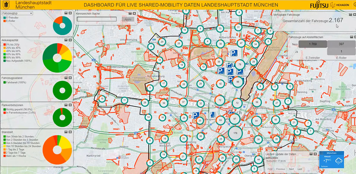
Partnership with Fujitsu will help city track bicycles, e-scooters and ridesharing companies
The mobility department of Munich, Germany, has selected Hexagon Geospatial to implement a smart monitoring system to better manage and understand the impacts of shared mobility services in the city.
Hexagon will partner with Fujitsu to provide Munich a software-as-a-service (SaaS) solution for tracking, visualizing and analyzing internet of things (IoT) data from a variety of mobility providers. The solution will monitor shared vehicles, such as e-scooters, bikes and cars, and will be the first of its kind in Germany.
The solution will also feature a dynamic digital twin of the city, allowing users to fuse the real and digital worlds and receive constant updates. Along with Hexagon’s M.App Enterprise software, Fujitsu will provide the necessary infrastructure for the project, which is designed to evolve constantly according to officials’ needs.
Hexagon was selected from among 14 competitors based on the technical completeness and capabilities of its offering and established expertise in the transportation domain. With this smart monitoring system in place, the city can continually monitor and guide future mobility concepts based on data.
“Shared mobility is a big issue around the world, and the city of Munich is on the leading edge of leveraging technology to manage these services,” said Maximillian Weber, senior vice president, EMEA, Hexagon’s Safety & Infrastructure and Geospatial divisions. “We are excited to deliver a system that will help officials better identify and understand transportation patterns with the goal of improving future city mobility.”
Tracking eScooters in Munich with Hexagon’s M.App Enterprise. (Image: Hexagon Geospatial)
GTX Corp will begin testing its new Cat M1 LTE SmartSoles across North America, Europe and Australia, and will begin the regulatory certification process for FCC/IC and CE.
The following week will begin the device network certification with Verizon, which will be providing the cellular connectivity for the North American market. GTX will also be testing with Orange and Telefonica for connectivity in Europe and Australia.
“With over 200 back orders and increasing demand every day, we intend to begin production as soon as we complete testing and certification, expected sometime next month, and then immediately start fulfilling all pre-orders and backorders first,” said Andrew Duncan, GTX Corp. director.
The patented and award-winning GPS SmartSoles were designed to address Alzheimer’s and autism challenges, where those diagnosed are at risk of wandering and becoming lost. Wandering is a safety issue with far-reaching implications for the person with the disease, their caregiver, law enforcement and healthcare providers.
GPS SmartSoles are placed in the wearer’s shoes. They contain a Nordic Cat M1 LTE GPS module connected through cellular networks that send a GPS location to the GTX central monitoring website and app. GTX is also upgrading its tracking app both for iOS and Android.
The SmartSoles can also be used by people at risk of kidnapping, such as government employees, journalists and corporate executives. SmartSoles come in three trim-to-fit sizes for men, women, and children, are water resistant, include an inductive charging pad, and are assembled in Rhode Island.
Movement, closeness, privacy — many things we took for granted a few months ago have become luxuries after the onset of COVID-19. To get an understanding of the scale and impact of the virus, we can look at global movement trends of people and merchandise using GNSS technology.
Marine
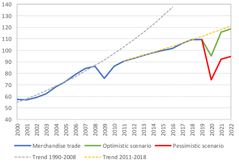
Before the coronavirus pandemic, globalization seemed to be increasing endlessly. Now, we face new trade restrictions, protectionist policies, and a global economic downturn that threatens to stunt growth for years to come.
In April, the World Trade Organization (WTO) forecast that global trade would fall by between 13% and 32% in 2020, surpassing the “great trade collapse” of 2009 spurred by the global financial crisis.
However, the situation isn’t completely bleak. According to a recent Tradeshift report, global trade decreased by 14.8% in the second quarter of 2020, putting us on the optimistic end of the WTO estimate. June saw a rise in trade activity, suggesting that we may be recovering from the initial effects of the pandemic.
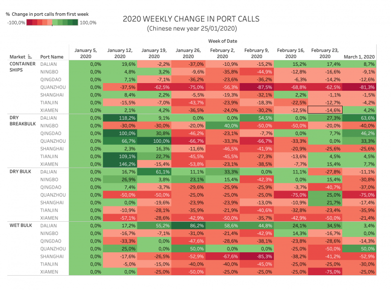
Cargo vessels, tankers, tugs, and other kinds of commercial ships are equipped with satellite navigation devices that can receive information from GNSS satellites to compute precise location and time. Maritime tracking insights obtained via GNSS/GPS signals are a great method for measuring the impact of the coronavirus on trade.
Photo: shaunl/E+/Getty Images
GPS data from MarineTraffic shows that ship arrivals decreased in nearly all of China’s ports from January to March.
Source: MarineTraffic
Just as trade shipping began to pick up in China, the United States and Europe were hit hard by the pandemic. However, shipments have now begun to climb worldwide to compensate for cancellations earlier this year.
The cruise industry, on the other hand, shows little indication of recovery. Cruises were the fastest growing segment of the travel industry over the past five years — until the pandemic hit.
On June 19, the Cruise Line International Association (CLIA) and Centers for Disease Control and Prevention (CDC) announced a “no sail order” for cruise ships. The order has been extended through Sept. 30. Furthermore, the cruise industry’s reputation has been damaged by multiple outbreaks on ships, most recently the MS Roald Amundsen of Norway. At least 43 people were infected on the MS Roald Amundsen, and Norway has now banned cruise ships with more than 100 passengers from disembarking at Norwegian ports.
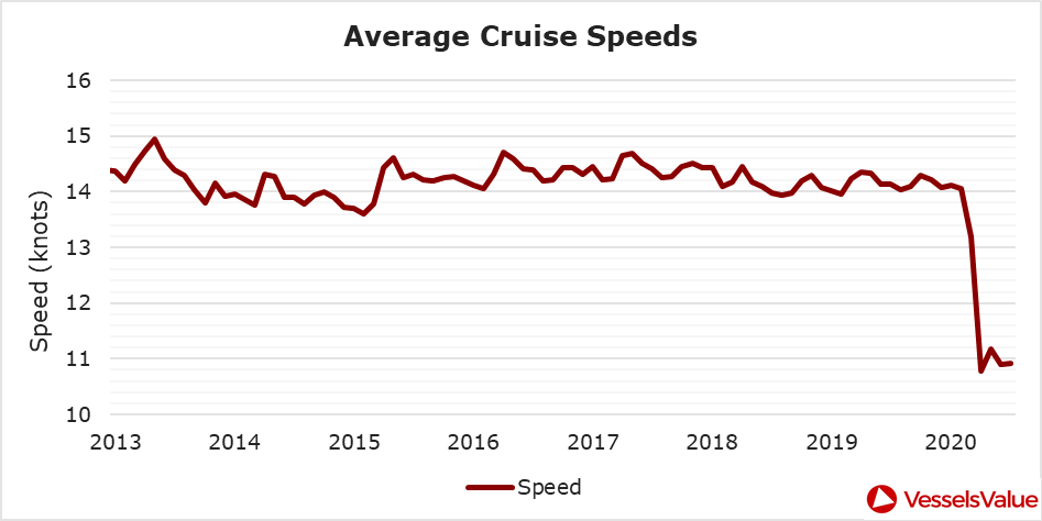
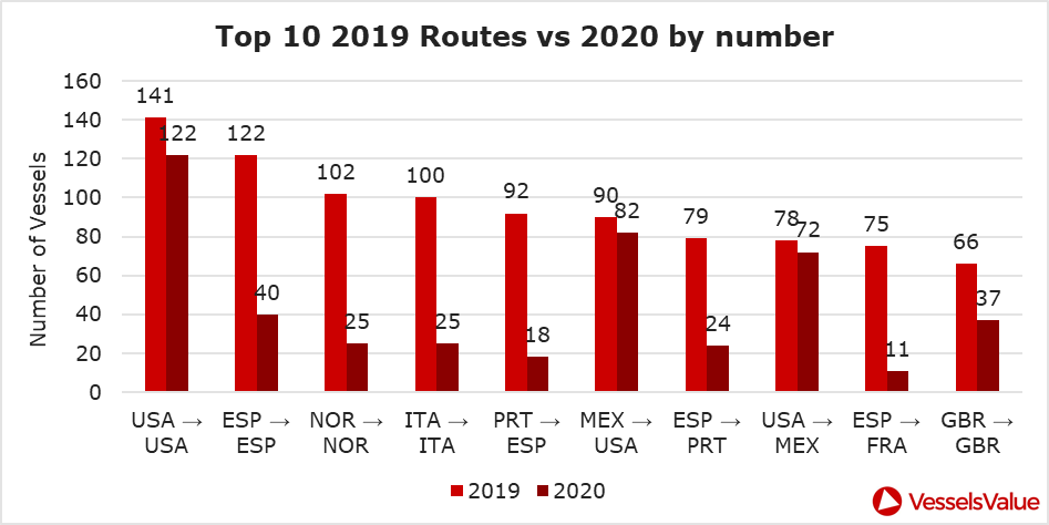
Maritime intelligence company VesselsValue is using AIS data to map cruise ship activity throughout the pandemic. They have noted that while cruise ships typically sail at 13.5 knots to 15 knots, average speed has dropped to 11 knots in 2020 as ships attempt to lower fuel costs. Port-to-port sailings have declined for the 10 most popular cruise routes.
Source: VesselsValue
Source: VesselsValue
Most of the port-to-port sailings that constitute the 2020 columns in the above graph actually represent ships being repositioned for a break in service, also called a “layup.” Layups can cost cruise companies millions of dollars per month, but with no sail orders and port closures, they are a necessary expense.
According to the Oxford COVID-19 Government Response Tracker, a real-time monitoring system that evaluates government policies, April marked the strictest lockdown measures across all 133 available coastal countries. The tracker uses a stringency index between 0 and 100 based on national containment and closure policies.
Source: Oxford COVID-19 Government Response Tracker
Air
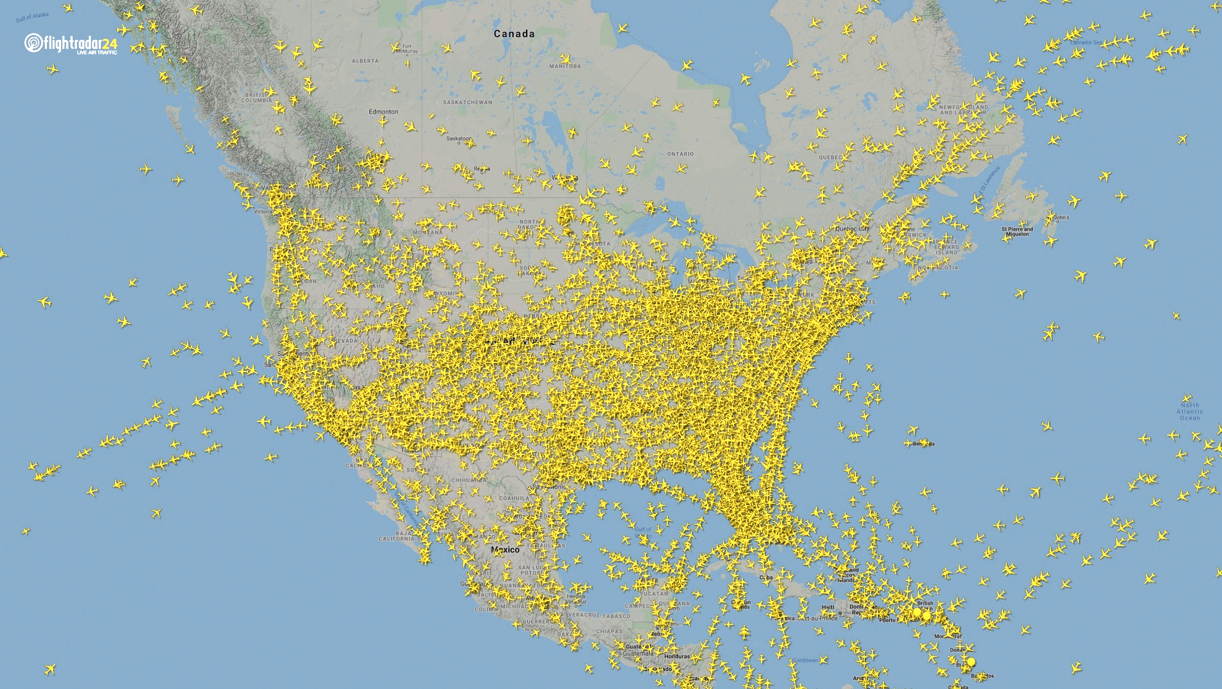
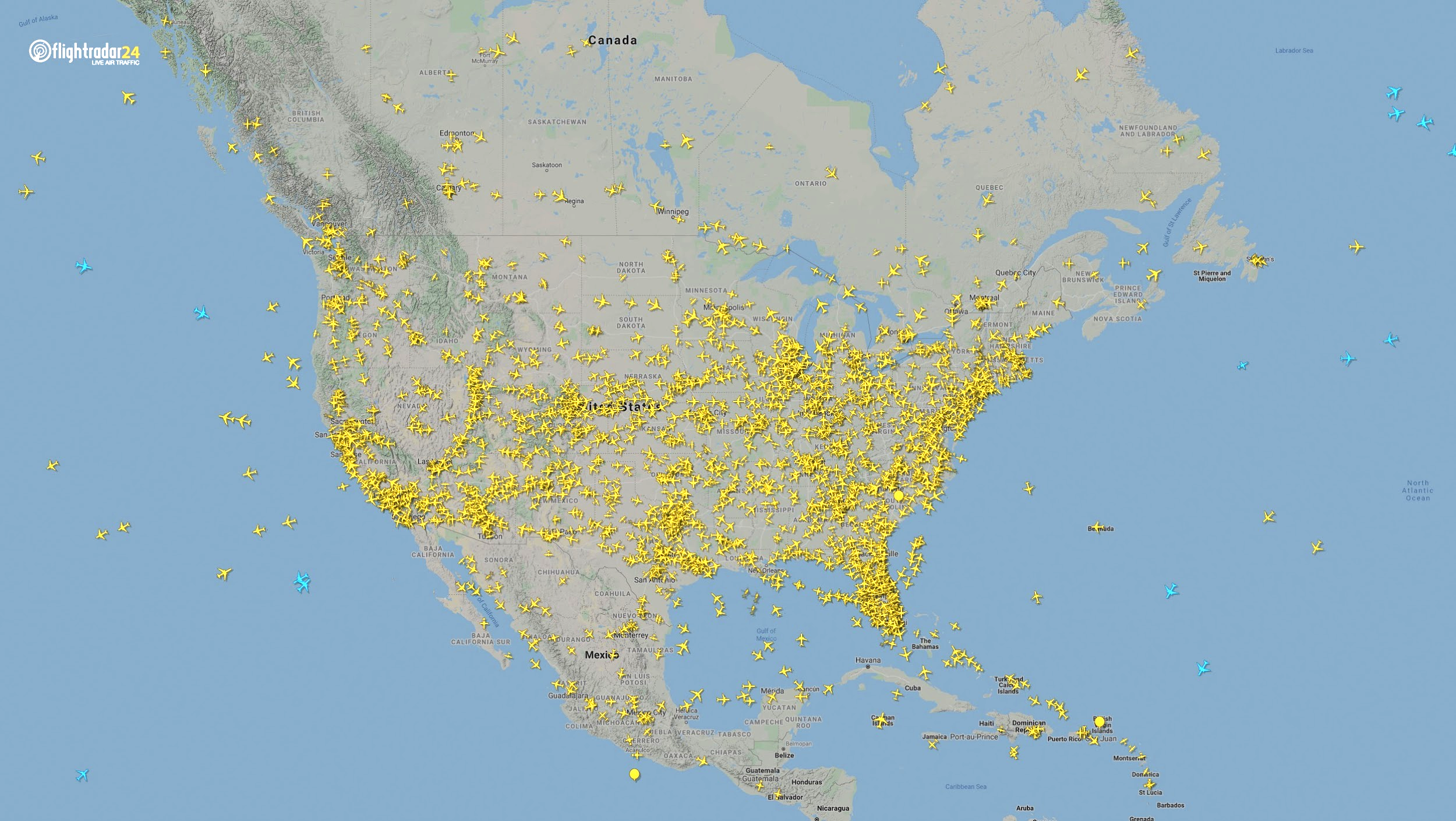
Commercial air traffic has decreased as well. According to GPS flight tracking service Flightradar24, the number of global daily flights was slashed by nearly two thirds between March and April. While there were 15,012 flights in the air at 15:00 UTC on March 7, there were only 5,275 at the same time on April 7.
Global air traffic March 7, 2020. (Source: Flightradar24)
Global air traffic April 7, 2020. (Source: Flightradar24)
There were 55% fewer flights in the last week of March 2020 than in the last week of March 2019. While all types of air traffic have been reduced for fears of infection, the coronavirus has especially decimated demand for passenger flights. Passenger airlines across the world have canceled flights and cut capacity for the foreseeable future. Some passenger airlines have even switched to transporting cargo in a desperate attempt to avoid bankruptcy.
Looking at regional tracking data can further illuminate the impact of COVID-19 on air travel. Travel restrictions and border closures were enacted en masse in late March, though some nations adopted more stringent policies than others.
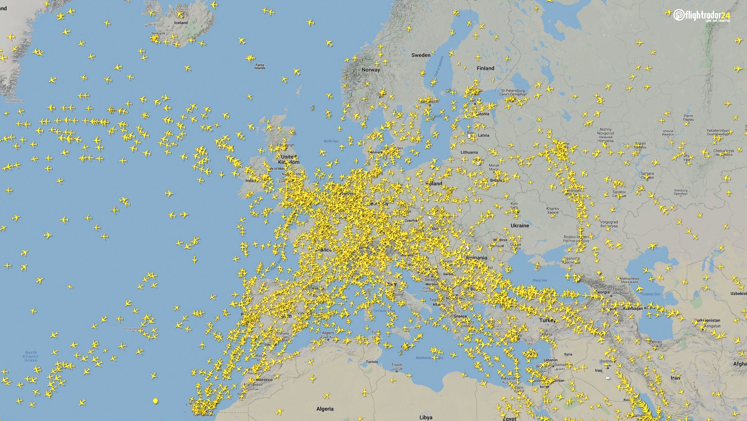
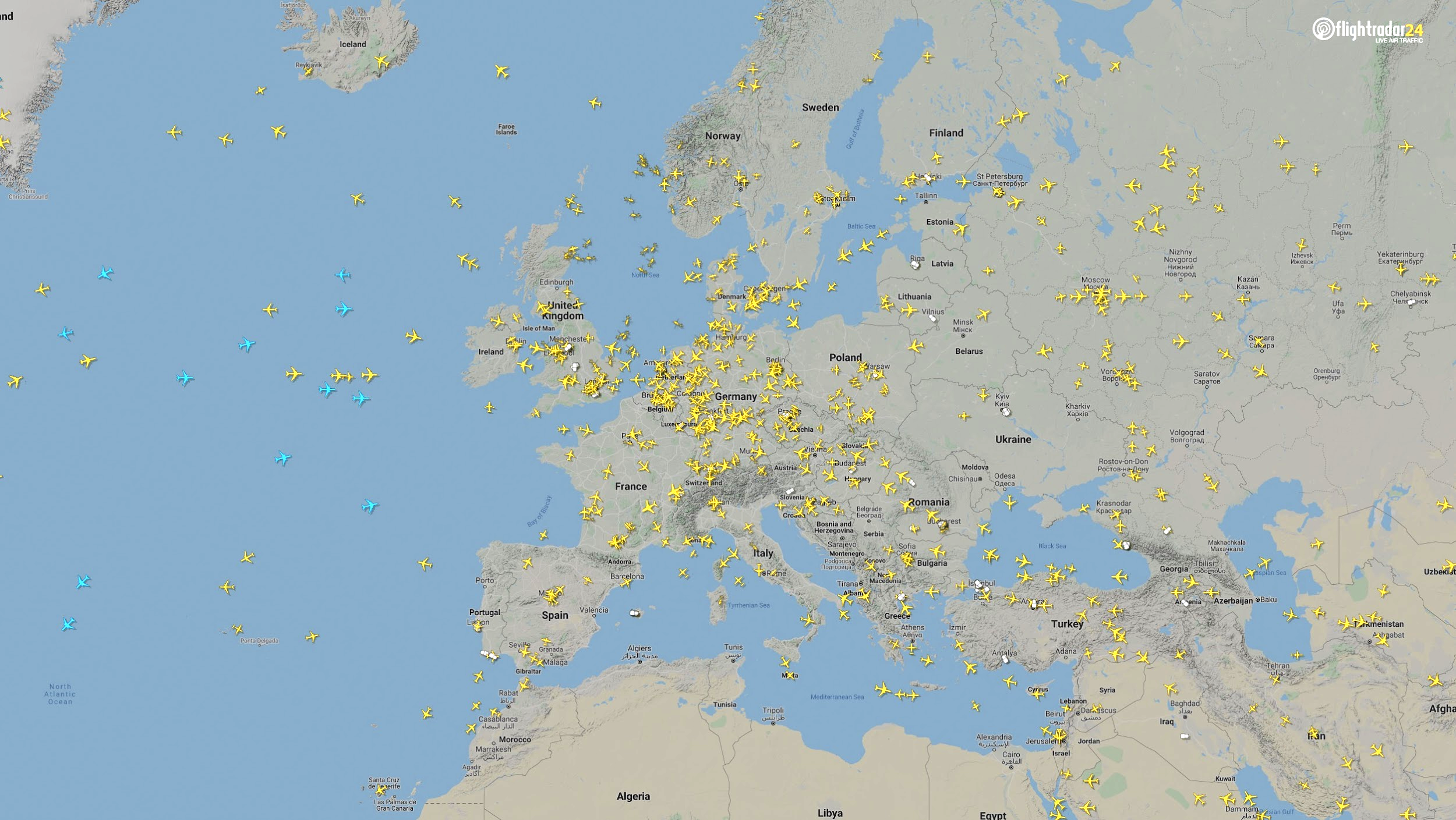
Europe
The number of flights in Europe has plummeted since the onset of the coronavirus pandemic. There were 2,400 fewer flights in Europe on April 7 than March 7.
Air traffic over Europe March 7, 2020. (Source: Flightradar24)
Air traffic over Europe April 7, 2020. (Source: Flightradar24)
North America
Though air travel has been disrupted across North America, the United States remains significantly more busy than its neighbors. The March 7 image shows 8,400 flights while the April 7 image shows 2,950 flights, most of them concentrated over the United States.
Air traffic over North America March 7, 2020. (Source: Flightradar24)
Air traffic over North America April 7, 2020. (Source: Flightradar24)
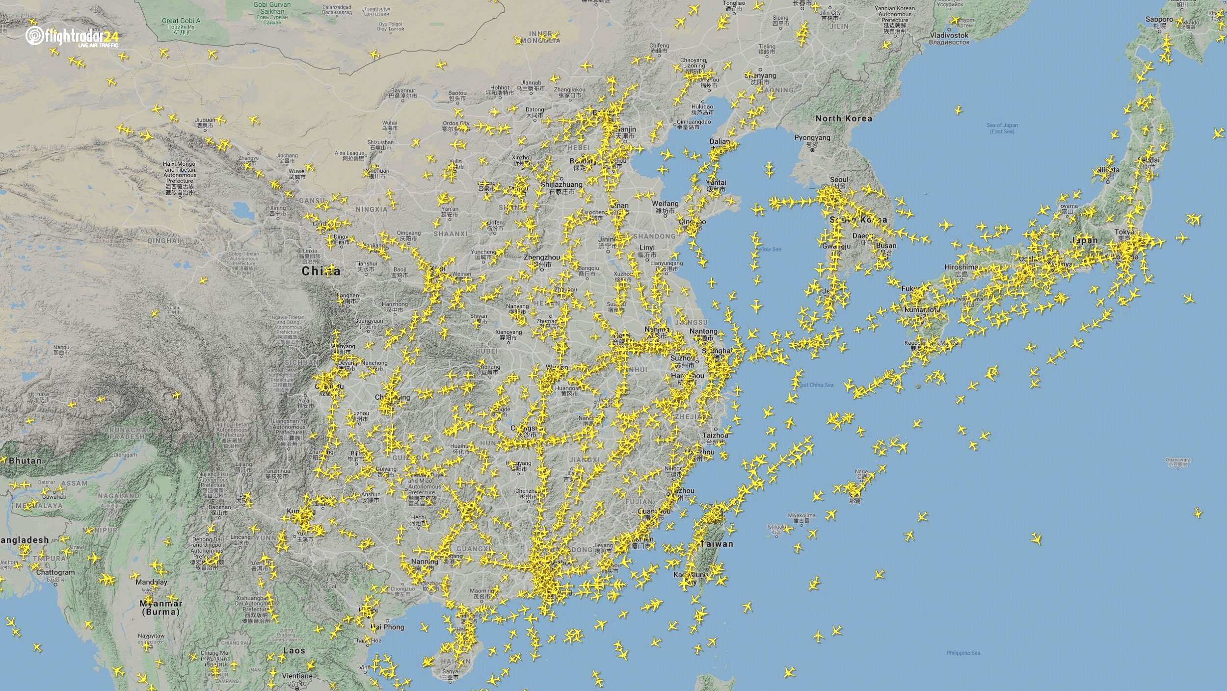
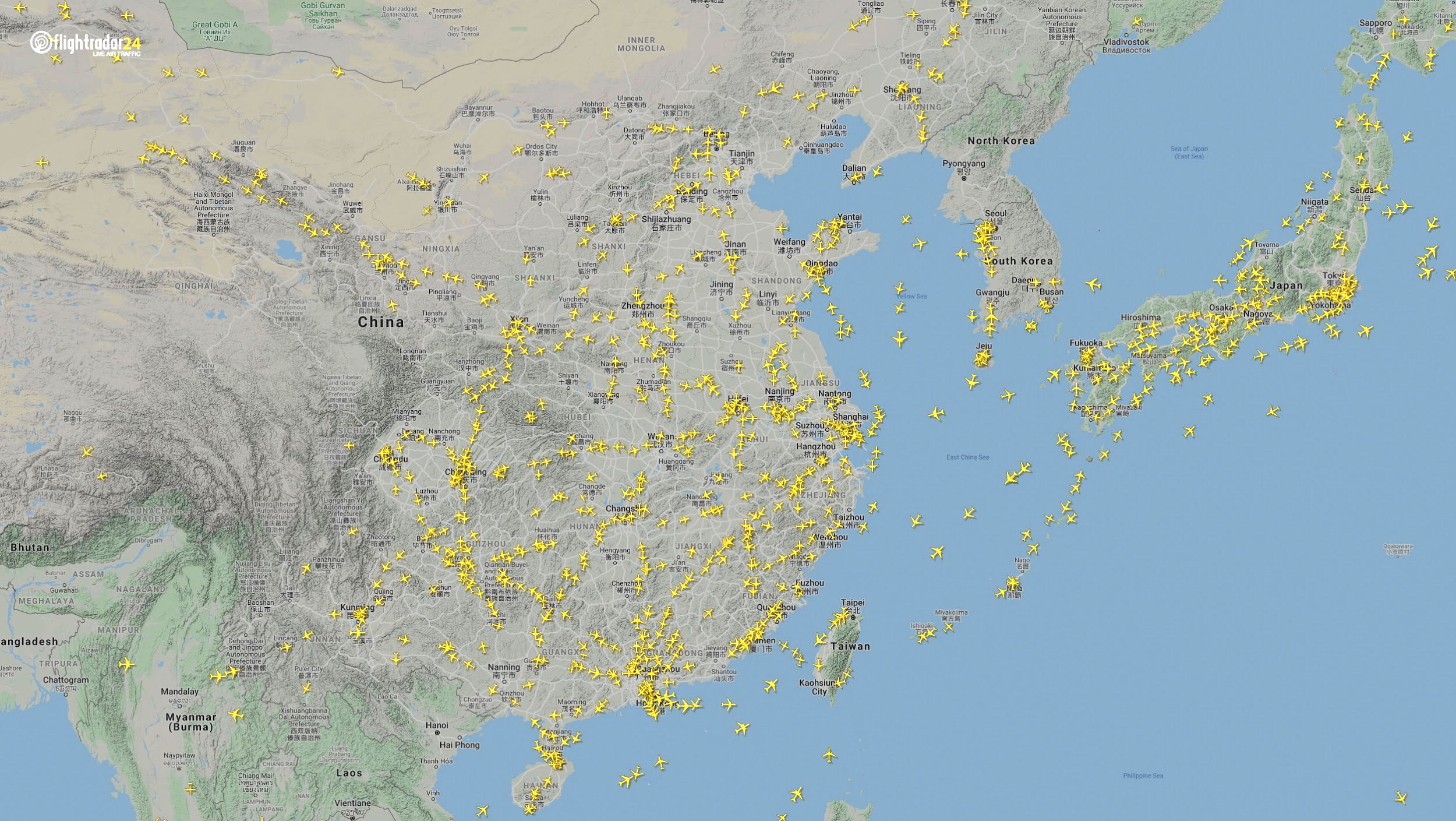
East Asia
The decrease in air traffic over East Asia has been severe and persistent. Since China and its neighbors began to experience a trade downturn as early as the third week of January, we can compare January 7 to April 7 to capture the effects of the coronavirus. As of late July, air traffic at China’s busiest airports was still down approximately 60% from normal levels.
Air traffic over East Asia January 7. (Source: Flightradar24)
Air traffic over East Asia April 7. (Source: Flightradar24)
Ground
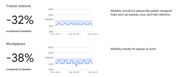
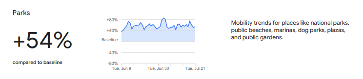
Google has released — and continues to update — a series of community mobility reports that chart movement trends in public spaces. The reports are a compilation of GPS data for Google users across the world.
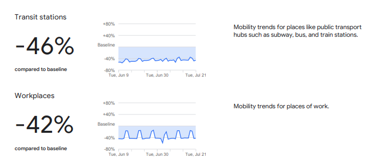
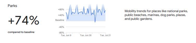
Mobility changes are particularly stark for regions hit hard by the coronavirus. New York state showed a 46% reduction in visits to transit stations and a 42% reduction in visits to workplaces in June and July compared to pre-pandemic baseline levels. New Yorkers are also visiting parks 74% more often.
Screenshot: Google
Screenshot: Google
Trends in the United States as a whole are also dramatic.
Screenshot: Google
Screenshot: Google
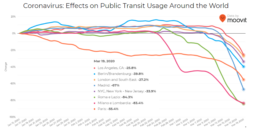
Israeli journey-planning app Moovit is using mobile phone data to document trends in public transit ridership. Many of the world’s largest metropolitan cities experienced a steep decline in ridership between mid-January and late March. Millions of people that rely on mass transit have had to cope with cumbersome rules and the danger of catching the virus itself. Efforts to reduce overcrowding on trains and buses have translated into reduced capacity requirements and therefore, lengthy wait times. The rise of remote work has also lowered public transit ridership.
Screenshot: Moovit
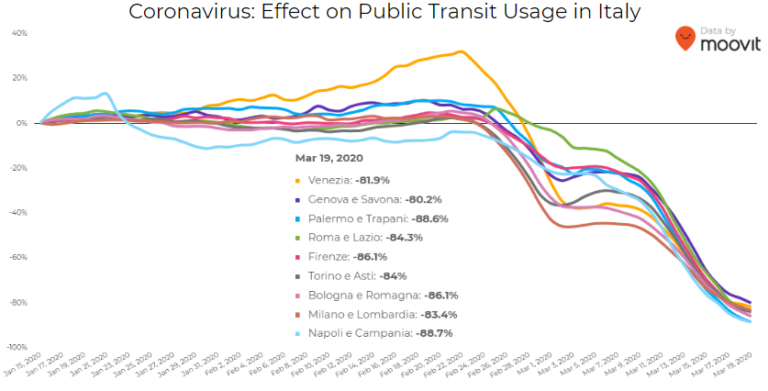
Italy was hit particularly hard – and early – by the pandemic. Two large outbreaks occurred in Northern Italy in late February, prompting widespread closures and government-mandated quarantines in Lombardy and 14 neighboring provinces. Public transit ridership plummeted when the quarantine took effect in early March.
Screenshot: Moovit
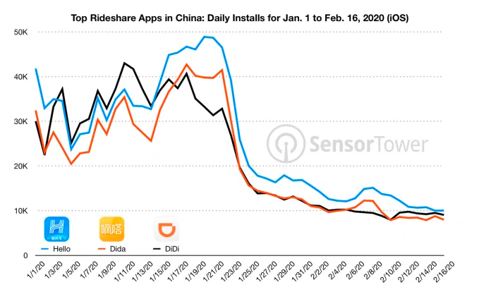
Usage of GPS-reliant ride-hailing apps has also dropped severely. Daily installs of China’s three biggest ride-hailing apps were down 75% the week of February 10 compared to the same week in 2019.
Source: Sensor Tower
American ride-hailing giants Uber and Lyft have seen similar losses. However, business for food delivery apps like Uber Eats and Grubhub are on the rise as more people stay home instead of grocery shopping.
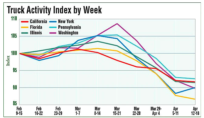
The impacts of COVID-19 have been less severe — but still significant — for the trucking industry. The U.S. trucking industry is an economic powerhouse, typically generating over 700 billion in annual revenue and transporting 72.5% of American freight. The American Transportation Research Institute generated a truck activity index based on GPS data across six states from the week of February 9 to the week of February 12. The data shows an initial spike in trucking operations due to increased demand for consumer goods and medical supplies. However, as stay-at-home orders and restrictions ceased business operations across the country, truck activity declined.
Source: American Transportation Research Institute
Coronavirus safety restrictions adopted by countries across the world have generally begun to loosen up, for better or for worse. It will be interesting to see how the coming months unfold through the lens of GNSS data.
Roi Mitt works for Regulus Cyber, a company researching GPS cybersecurity and offering various software products to protect the integrity, reliability and security of GNSS devices. The company’s products are designed for multiple industries using GPS-based time and location, in order to ensure a future in which GNSS technology is safe and reliable to use.
No, I’m not talking about the line at the grocery store to buy toilet paper and hand sanitizer. Or the line at the doctor’s office. I’m talking about that gray privacy line invisible to the naked eye, but all too accessible on our mobile devices.
On March 16, Israeli Prime Minister Benjamin Netanyahu and his cabinet approved using citizens’ smartphones to track the locations of people infected with the novel coronavirus (COVID-19), as well as anyone they might have had contact with.
Such a strategy might work — some citizens reported receiving smartphone alerts when they were near an infected person. However, it does raise the ubiquitous privacy concerns of allowing your government to know your every move.
Some may think this an acceptable use of tracking, except that the Israeli Knesset — the citizenry’s representative legislature — was not involved in the decision. The tracking didn’t require a court order, and records were to be kept until the new regulation expired.
A few days later, Israel’s top court put a stop to the program, saying there would be no tracking of Israelis by the Shin Bet without Knesset oversight.
Of course, Israel is a democracy, and Netanyahu’s move is nowhere near the draconian measures undertaken by the Chinese government in response to the virus. Those actions included forcibly removing people from their homes and placing them in quarantine.
Yet China’s actions worked. As of press time, the outbreak there is under control, with no new cases reported on March 19. That’s impressive, if one can trust the state news. After all, this is the same country that warned the doctor who discovered the virus not to talk about it. Dr. Li Wenliang died in February of the disease.
Privacy versus public health: Something to think about while social distancing at home.
UPDATE: Israel’s High Court of Justice put a stop to the tracking on Thursday, March 19. The court declared that the Shin Bet security service may not track confirmed and suspected coronavirus patients if a Knesset panel to oversee this practice isn’t set up by noon Tuesday, according to Israel news agency Haaretz.
Israel’s internal security agency Shin Bet is using citizens’ smartphones to track the locations of people infected with the novel coronavirus (COVID-19) as well as anyone they might have had contact with, news agencies are reporting. Some citizens report receiving smartphone alerts when they have been near an infected person.
Privacy concerns. The tracking doesn’t require a court order and records will be kept until the regulations expire, according to Israeli news source Haaretz. The regulation can be renewed, and the country’s Health Ministry can keep the location records for 60 days after the regulation expires.
Israeli Prime Minister Benjamin Netanyahu told The New York Times that the government would approve the plan Monay night. “We have to maintain the balance between the rights of the individual and needs of general society, and we are doing that,” he told the newspaper.
No legislature involved. The plan was reportedly approved by cabinet members without approval of the Knesset, the Israeli legislature, which has just been sworn into office and has not yet convened.