The TraceME module TM-178, targeted for tracing and controlling vehicles and other powered equipment, is now upgraded with optional LoRa, Wi-Fi, Bluetooth Smart (BLE), ANT/ANT+ and proprietary RF. The upgrades enable integration with existing wireless networks and specific custom mobile apps on smartphones and tablets.
The KCS BV LoRa technology offers a communication range up to 60 kilometers, line of sight. The module offers an advanced indoor and outdoor location-based positioning solution, which covers a variety of Internet of Things (IoT) applications and enables stolen object or vehicle recovery.
The TM-178 is equipped with external power and battery backup connection, basic I/O-connectivity and multiple on-board sensors. The unit contains multiple integrated antennas for GPS/GLONASS, GSM (2G/3G) and RF functionality. The functionality of the module can be remotely programmed to fit any job. From basic/general functionality to advanced/low-level application specific detailed functionality.
With a compact size of 91 x 40 millimeters and weighing 30 grams, along with a battery lifespan of more than 10 years, the module offers endless OEM integration possibilities. Optionally, the module can be ordered in a robust IP67 housing.
TM-178 Features
GPS
GSM/GPRS/EDGE coverage
Basic I/O-connectivity
Long-range RF coverage
Optional Features
GPS + GLONASS
UMTS/HSPA+
LoRa
Bluetooth Smart (BLE), ANT/ANT+, iBeacon
Wi-Fi
Robust IP67 housing
External RF antennas
Internal battery, no need for external power supply
Xsens has launched BASE, an online technology platform with a community forum and a knowledge base on 3D motion tracking technology and products.
On BASE.xsens.com, the knowledge base contains inside information about micro-electro-mechanical system (MEMS) sensors, inertial measurement units (IMU), sensor fusion algorithms, body-motion tracking and motion capture.
It also provides best practices, tips and tricks for the use of Xsens’ successful products the MTi series, the MTw and the MVN wearable motion capture solutions. A second section of BASE is the community forum with direct access to Xsens’ engineers and other Xsens users.
The knowledge base and community forum make it easier to integrate the MTi or MTw and to get the most out of MVN. If a question is not answered in the knowledge base, it is straightforward to ask a question to the community. With short response times from either other Xsens users or the entire Xsens engineering team, the user community is a quick way to continue development, Xsens said.
BASE is a next step by Xsens to support the growing community and interest in inertial technology. It further enhances the interaction between users and Xsens.
“Although Xsens makes it easy to use inertial technology in their applications, the underlying technology is complex and there are many features for specific applications,” said Remco Sikkema, Xsens marketing manager. “Understanding the technology makes it easier to integrate the products and be successful with Xsens.”
With BASE, engineers and engineering teams in the Xsens community can come closer together. The primary goal is to make Xsens customers more successful by providing a platform to exchange information.
There is no need to register for BASE to access the community forum and the knowledge base. To ask questions or comment on articles, registration is possible via SSO or email.
Cargo that comes into the Rotterdam, The Netherlands, shipping port could very well be guided by a new GPS system.
APM Terminals Rotterdam operates at the important European gateway with a fleet of more than 70 straddle carriers. The straddle carriers have been equipped with GPS Lite, made by U.K.-based International Terminal Solutions (ITS).
GPS Lite tracks the straddle carriers.(Photo: ITS)
GPS Lite, the latest version of ITS’s G-POS GPS tracking system, provides real-time visibility so that valuable resources aren’t wasted hunting for or handling misplaced containers.
Testing. To ensure the new system was rolled out smoothly and provided the required reliability and accuracy, extensive tests were done on two straddle carriers.
Following the success of these tests, the system was rolled out in phases to the rest of the fleet.
APM Terminals Rotterdam uses the COSMOS Terminal Operating System. For COSMOS users, G-POS connects to the radio data terminal on each straddle carrier in the same way as the legacy system it replaced.
It is fully compliant with COSMOS interface specifications and uses the same cable connections to make the system swap compatible.
Rotterdam port: A straddle carrier is in the foreground. (Photo: APM Terminals Rotterdam)
ITS can provide a range of GPS accuracy options wih G-POS, depending on customer needs. Accuracy can range from 2 centimeters up to 0.7 meters, with various types of differential GPS correction methods used.
G-POS provides automated, real-time, error-free data, enabling a live accurate database to improve storage and retrieval decisions, and to optimize equipment use.
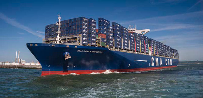
The container shipping industry uses between 20–25 million containers, only a small number of which are tracked. A company called Traxens is on the verge of changing that.
In July, the Switzerland-based Mediterranean Shipping Company (MSC) joined worldwide container shipping company CMA CGM to invest in the French start-up. Under the deal, both CMA CGM and MSC will be represented on the board of directors of Traxens.
Traxens cargo tracker. (Photo: Traxens)
CMA CGM and MSC transport about 25 percent of the world’s shipping containers.
Established in 2012, Traxens has been developing solutions for the cargo logistics sector and has created a new multi-modal container monitoring and coordination system to provide real data for logistics.
By the last quarter of 2016, CMA CGM and MSC will have installed Traxens devices across their fleets.
“We see container monitoring as an important innovation in providing our customers with a high quality of service, while also being able to monitor our outputs accurately,” said MSC CEO Diego Aponte. “We believe that shipping lines should naturally compete on service, but should cooperate in the area of technology and innovation.”
“This should be the start of deployment on a massive scale,” said Tim Baker, Traxens director of marketing and communications.
CMA CGM, which has been backing Traxens since 2012, said that the investment is a part of its global digital strategy. Its 536 vessels call on more than 420 world ports. MSC operates an integrated network of road, rail and sea on more than 200 trade routes.
Each Traxens device has GPS on board, but other methods can be used to save battery life, which affects the overall cost of ownership of the solution. “For instance, once we have determined that a container is on board a ship, we can use the AIS ship-positioning data rather than the GPS on the device — especially as the device may be under deck with no view of the sky,” Baker said.
Also to save power, critical decisions on location are made by the devices locally rather than transmitting position up to the cloud and making decisions there. “It is much less power hungry to evaluate GPS position on the device, compare location with expected location, and then decide whether the information is worth transmitting than to send each position to the cloud just in case it happens to be interesting,” Baker explained.
KCS BV has upgraded its successful TraceME module TM-178, targeted for tracing and controlling vehicles and other powered equipment.
The TM-178/R9H7 module has been upgraded with optional LoRa, Wi-Fi, Bluetooth Smart (BLE), ANT/ANT+ and proprietary RF, which enables easy integration with existing wireless networks and specific custom mobile apps on smartphones and tablets.
The LoRa technology offers a communication range up to 60 kilometers line of sight. The module offers an advanced indoor and outdoor location-based positioning solution, which covers a variety of Internet of Things (IoT)-applications and enables stolen object and vehicle recovery.
The TM-178 is equipped with external power and battery backup connection, basic I/O-connectivity and multiple onboard sensors. The unit contains multiple integrated antennas for GPS/GLONASS, GSM (2G/3G) and RF functionality. The functionality of the module can be remotely programmed to fit any job, from basic/general functionality to advanced/low-level application-specific detailed functionality.
With a compact size of 91 x 40 millimeters, weight of 30 grams, and a battery lifespan of more than 10 years, the module offers endless OEM integration possibilities. Optionally, the module can be ordered in a robust IP67 housing.
Above is the STORIES documentary video holiday card, which contains images of Yassan’s journey and the people and places he encountered along the way.
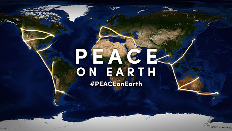
The daytime version of Yassan’s world-stretching art message of peace.
Peace on Earth: That’s the message spelled out across the globe by GPS artist Yassan in time for the holiday season.
Yassan created a massive, international work of GPS art around the theme of world peace and, in the process, is attempting to break his own Guinness world record for the largest GPS drawing. Yassan is the Guinness world record holder for the largest GPS drawing by an individual. GPS World previously reported on his “Marry Me” project.
Yassan visits Times Square in New York City, at coordinates 40.7593 ° N, 73.9852 ° W.
With the help of Japan Airlines and its partners, Yassan’s latest project covered 65,700 miles (105,734 km) around the globe, beginning in Tokyo and ending in San Jose del Cabo, Mexico. He traveled through Asia, Oceania, the Middle East, Europe, Africa and the Americas, and visiting 24 cities on six continents.
To create his GPS drawings, Yassan carries an iPhone and GPS tracker that records his GPS location data as he travels. He then uploads this information to create a drawing on a map. The finished piece of GPS art — a planetary-scale holiday message for the world — spells “PEACE” across the planet.
Yassan visits with Buddhist Monks in Colombo, Sri Lanka: 6.9165° N, 79.8568° E
While a relatively new art form, GPS art is a natural progression stemming from much older, large-scale art forms. “In tracing the history of GPS art, you can draw a clear line of artistic evolution,” said Yassan, “beginning with the ancient Nazca lines in Peru, through Michael Heizer and his work with motorcycle tracks in the Nevada desert, to Richard Long’s walks through the English countryside, to the modern GPS artists.”
Yassan continues, “Peace on Earth has proven very difficult to achieve, but is, at the heart of it, a very simple concept. I hope that this holiday message can convey this idea to the world.”
A stop in London near Parliament: 51.5007° N, 0.1226° W
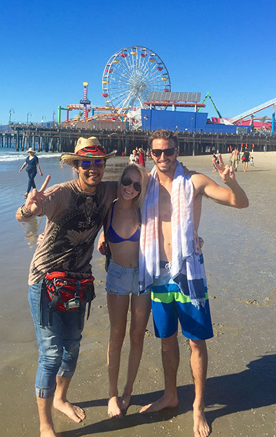
On this journey, a video production crew, led by director and STORIES creator client Mark Apicella, accompanied Yassan, documenting the creation of this artwork as well as the artist’s interactions with local people at each of the 33 stops along this epic journey.
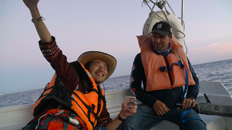
Yassan makes a stop in Los Angeles with a visit to the edge of the continent, at 34.0074° N, 118.4966° W.Yassan celebrates at his final stop to complete the downstroke of the “P,” at a place appropriately named “El Fin de la Tierra” — the end of the Earth, near Cabo San Lucas, Mexico: 22.8741° N, 109.8962° W.
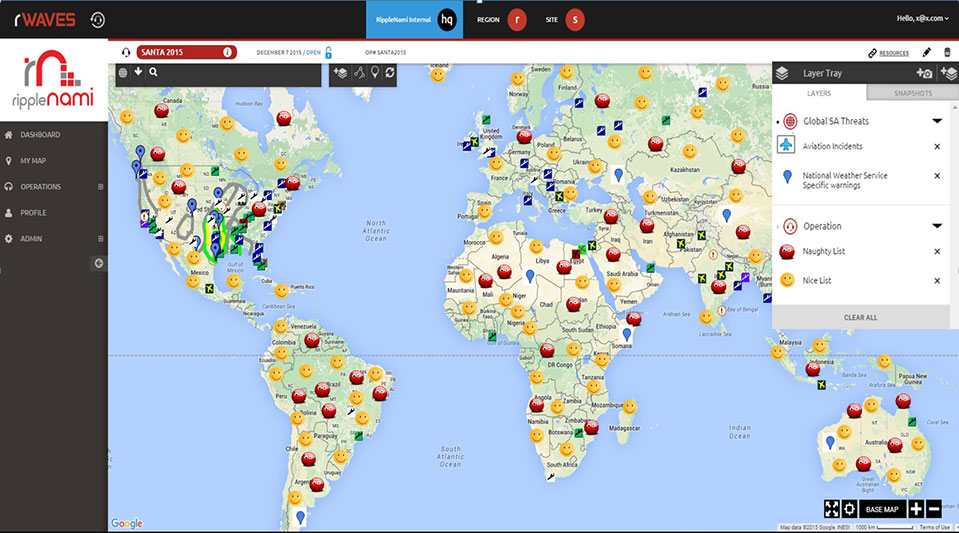
This holiday season, Santa Claus is using innovative technology to become even more efficient. He will be using RippleNami, a cloud-based visualization platform, to efficiently and safely deliver presents.
Our favorite jolly man is one busy fellow. Not only does he have to keep track of the naughty and nice kids all year long and make the appropriate number of toys and lumps of coal, he then has to visit the homes of children all over the world in a single night. There are many things Santa has to keep in mind as he’s planning his yearly trek across the globe — such as weather conditions, flight patterns of other aircraft, and which homes have chimneys. How does Santa possibly keep track of everything?
RippleNami, a cloud-based visualization platform, allows users such as Santa to access data from countless sources and customize information layers into an easy-to-use map. Below is a snapshot of the data Santa can integrate into the RippleNami platform to efficiently and safely deliver presents this year.
Weather Conditions — Poor weather conditions can significantly impact Santa’s route. Fog in particular has traditionally been a difficulty, even with the help of Rudolph’s nose. RippleNami allows Santa to track fog in real time, so he knows when Rudolph’s nose is necessary, and when the reindeer can take a break.
Aviation Incidents — Santa’s sleigh isn’t the only thing flying on Christmas Eve. Tracking flight patterns and visualizing where aviation incidents have recently occurred help Santa avoid collisions and plan the fastest route.
Naughty and Nice Lists — Santa is diligent in keeping track of which kids are naughty and which are nice. He makes a list, and checks it twice! But even Santa could use help planning how many toys versus lumps of coal he needs to pack in his sleigh before the big night. And what if a child who has been nice all year long suddenly throws a fit Christmas Eve? With RippleNami, Santa will be alerted in real time and can pick up some extra coal accordingly.
Here is a visual of what Santa sees when he’s using the platform.
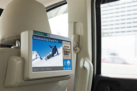
With the service, media players display a content loop with information specific to the vicinity of the vehicle.
MediaSignage has released GPS-powered, location-based services (LBS) for digital signage. The tool provides specific geo-targeting of advertising campaigns based on the location of the screen.
The GPS-enabled location targeting works well for buses, taxis and trains, because advertisers can more easily target their digital signage content based on a targeted geographic radius, MediaSignage said in a press release.
For instance, a taxicab may provide digital signage behind the headrest and allow local advertisers to target messages to patrons that ride within the cab. When a moving car, bus or train enters the desired radius (such as close to a specific restaurant or local venue), the installed media player displays a new content loop with information specific to the vicinity. Once the media player moves out of that vicinity, the original content loop resumes.
MediaSignage has designed the tool to be simple and affordable, enabling any business owner to have their message presented in a matter of a few minutes. Users can log in to StudioLite, set the radius on a map, and set the priority duration for each content resource that is to be displayed. Users can set radius location information for several desired areas within a geographic footprint.
When users combine the power of GPS tracking into moving digital signage, the ability to target for advertising purposes becomes extremely powerful, MediaSignage said. Placing local advertisements in taxi, bus, train and even Uber cars provides a powerful tool for selling ads and targeting customers.
“We are extremely pleased and excited by this latest feature implementation within our system,” said MediaSignage president Nate Nead. “It provides an additional value-adding tool for digital signage business owners and operators, allowing them to better monetize their display screens in a host of different and non-traditional environments. We hope our users will take full advantage of the new features and that the features will provide a profit-enhancing tool for their businesses.”
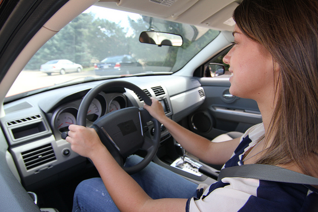
Telit’s cellular and GNSS Internet of Things (IoT) modules will integrate Yon Motor, a new product from Nastek Indústria e Tecnologia, bringing to market a tiny vehicle tracker with a user-friendly mobile app. Besides vehicle security, speed is a top concerns for parents of teenage drivers. Yon Motor targets this market, delivering real-time location and speed data to a smartphone app along with a number of vehicle security features.
The innovative project was developed in partnership with Telit. The company’s GL865-QUAD and SL871 GPS modules are integrated in the miniature Yon Motor to deliver machine-to-machine communication and location awareness respectively. The free Yon Motor mobile app is available for download in iOS and Android.
“What parent would not want to know about their children’s night out or would not sleep better knowing that they are respecting speed limits? The idea of Yon Motor was to create something that could get people closer through Internet of Things,” says Lauro Cruz, CTO, Nastek. The Yon Motor tracker was built with latest generation technology. Moreover, the solution is lightweight and waterproof, permitting parents to secure it to any motor vehicle.
“The Yon mobile app lets users follow vehicle movements in real time and can be downloaded for free to a smartphone. The tracker helps combat car accidents involving young people, since parents have full visibility of their children’s driving speeds and the routes they take,” Cruz said.
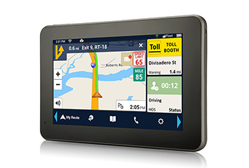
The Magellan RoadMate RC9496T-LMB commercial navigator.
Magellan is integrating its RoadMate RC9496T-LMB fleet navigation device with Position Logic’s advanced GPS tracking software solution. The partnership allows Position Logic service providers to leverage all Magellan RoadMate RC9496T-LMB devices.
The RoadMate RC9496T-LMB, a 7-inch Android GPS fleet navigation device, is available now to current and prospective Magellan and Position Logic customers. Position Logic, a division of KORE, provides precision location-based services for business-to-business applications.
The Magellan and Position Logic integration delivers a powerful and seamless end-to-end communication and navigation solution for fleets, the companies said. The solution includes the RC9496T-LMB, an active mobile terminal, allowing real-time two-way communication between driver and dispatch when paired with Position Logic’s GPS tracking software. Users can send and receive important information to immediately identify driver status including route-receipt, in-route or on-scene, and deliver real-time messages to improve driver productivity. The solution delivers critical information for field service fleets, emergency services, roadside assistance and many more applications.
“Position Logic is an innovative technology leader in the location based services space. We are pleased to partner with them and offer the Magellan RC9496T-LMB to Position Logic customers,” said Stig Pedersen, associate vice president of product management for Magellan. “The combination of our two services delivers a highly efficient and flexible way for dispatchers to communicate with drivers in real-time, saving time, money and frustration.”
The RC9496T-LMB is also connected to Magellan’s SmartGPS Eco cloud, providing drivers and fleet managers with customizable time and money saving content such as: real-time fuel price information, weather and truck speed limit warnings.
“We are pleased to have the RoadMate RC9496T-LMB integrated. The Magellan integration further complements our Workflow/Dispatch module; improving communication between the dispatcher and driver and enhanced stop management,” said Felix Lluberes, executive vice president, advanced applications, KORE. “I am certain our service providers will be able to leverage the device and deliver more comprehensive services.”
The Magellan RoadMate RC9496T-LMB is available now. It has an MSRP of $399.
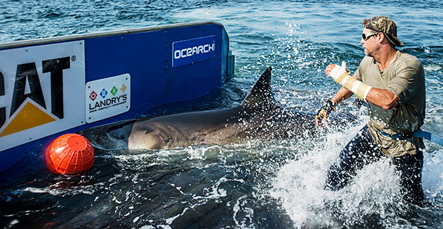
Global Tracking Project Demystifies the Ocean’s Top Predators
Chris Fischer helps tag Katharine, a 14-foot 2-inch, 2,300-pound great white, on Sept. 17, 2012. Katherine cruises the East Coast of the United States. (Photo: OCEARCH)
By Tracy Cozzens Photos courtesy of OCEARCH / R. Snow
Where are sharks? What are their migratory patterns? And how close do they come to shore? Until recently, the life cycle of sharks has been a mystery. The nonprofit OCEARCH is tagging and tracking a variety of sharks, and sharing the data with scientists around the world.
OCEARCH’s Global Shark Tracker app.
Since 2007, OCEARCH has tagged a total of 200 sharks, including 80 great whites, 80 tiger sharks and a few smaller species. About 50 tags are actively sending data to a publicly available shark tracker, also accessible with an iOS and Android app. OCEARCH also has popular Twitter feeds and Facebook pages for its most famous sharks, and Mary Lee (@MaryLeeShark, 86,100 followers) and Katherine (@Shark_Katharine, 32,300 followers). The access has changed the conversation from fear of a shark interaction to curiosity about their movements and life cycles, explained OCEARCH Founder Chris Fischer.
Before the shark tracking project, “We lacked the critical data on our large apex predators’ life history. We didn’t understand where they were mating, where they were giving birth, and these large complicated migrations that they make,” Fischer said.
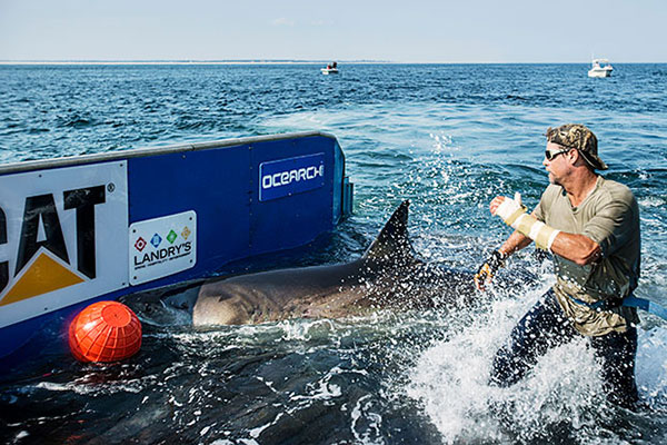
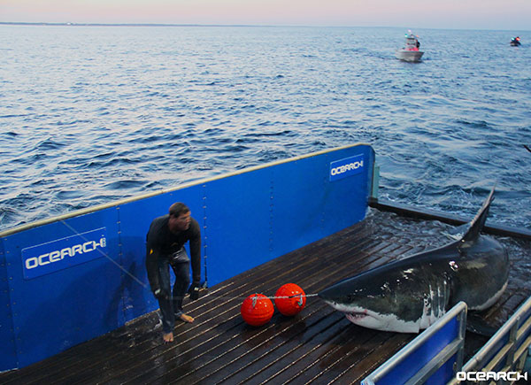
Pulling a great white shark from the water long enough to tag it was a daunting hurdle that OCEARCH overcame by bringing together professional mariners, ocean experts and the academic community to solve the problem. The answer is a hydraulic lift system designed for shark tagging installed on the M/V OCEARCH research vessel. Once a shark is on the line, it’s maneuvered into a custom hydrauic lift. The 75,000-pound-capacity platform is designed to safely lift mature sharks for access by a multi-disciplined research team, who rush to conduct about 12 studies within 15 minutes before setting the shark free. The shark is guided by hand in the water on and off the lift.
This hydraulic lift allows scientists to pull in and tag a live mature shark, in this case Mary Lee.
Once OCEARCH figured out how to capture and tag the sharks, the organization invited multiple institutions to share the data. “We decided to open source the data and give the tracking data away so that the world could track the sharks and be involved in the project at the same time as the Ph.D.s. And that’s where the Global Shark Tracker really came about: it was including the world in solving this puzzle in real time in this journey.”
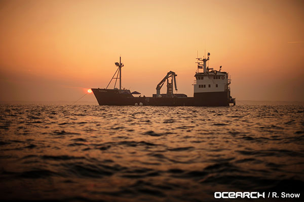
The M/V OCEARCH now travels around the globe “to help the scientists who study our ocean’s giants explode their knowledge forward as fast as we can,” Fischer said. “So we have the critical data we need to keep these balance-keepers, these lions of the ocean, our large sharks with a bright future.”
Research expeditions are conducted worldwide aboard the M/V OCEARCH, which serves as both a mothership and at-sea laboratory.
The long-term goal is gaining a clear picture of the sharks’ needs, so that the oceans can be properly managed. “They’re the fundamental building block of the future of the ocean. If we don’t understand our apex predators, the top of the food chain, if we don’t understand how to manage them toward abundance, then we can’t manage the whole system toward abundance,” Fischer said.
More than 50 of the world’s leading institutions and more than 80 ocean scientists are involved collaborating and sharing data, a different paradigm from the classic way researchers work. “We realized quickly the old institutional way of researchers holding their data close to the vest and not sharing it with the world, trying to get ahead of one another to get papers published, wasn’t really effective for creating a movement and awareness around the future of the ocean at scale,” Fischer said.
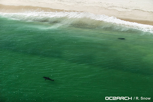
Great White shark Katherine spotted by plane before being captured and tagged.
Information on where and when sharks swim and migrate can be leveraged for public safety, Fischer said. “Once we solve the puzzle of the migrations, the sharks then repeat the migrations to the same areas at the same times of the year. It allows people to get the rhythm of their lives and understand when they’re passing through their areas, and when they’re there and when they’re not.”
The sharks are tagged accelerometers, and with SPOT trackers from Wildlife Computers (short for Smart Position and Temperature Tag). Data from the accelerometers show that the animals regularly recover and start swimming strongly within 2–4 hours after release. Data from the Global Shark Tracker provides strong evidence that the animals tagged show long-term survival and long-distance migrations indicative of normal function and reproductive cycles, according to OCEARCH.
A SPOT tracker (top) and an accelerometer are attached to Mary Lee’s dorsal fin.
SPOT tags are designed to function in salt water. The tag is mounted on a shark’s dorsal fin and provides location data when a shark’s fin breaks the surface for at least 90 seconds. The five-year battery life of the trackers has helped scientists decipher the sharks’ three-year migratory loops. After that time, the sharks tend to shed the trackers. “We just borrow that access for five years, to solve the puzzle and collect the data,” Fischer said.
The data from OCEARCH has revealed that sharks come right to shore, into the breakwater, more often than most people thought. Also, their range is much bigger than expected, with some juvenile sharks discovered migrating all the way from Cape Cod to New Orleans.
Wearable fitness trackers such as FitBit could help military patients recover quicker, according to Col. Deydre Teyhen, an official with from the Defense Health Headquarter’s Office of the Surgeon General. The trackers could help patients with musculoskeletal conditions gauge how much physical activity they can handle without exacerbating their injuries, Teyhen told an audience at a conference hosted by tech association, AFCEA and reported by NextGov.
Device-agnostic software is needed to allow soldiers to use the devices they already own, she said. “The question becomes, is it a one-size-fits-all solution?”
For instance, some patients begin to feel better before their soft tissue heals fully, and start walking around more, which could inhibit their recovery process, she explained. An effective system might send that patient a notification on their fitness tracker to say, “‘You’ve done great, at 1,000 to 2,000 steps a day,’ and it gives you a warning … ‘You might actually be doing too much and you might cause a setback.’ If you give them that warning in real time, then they can change their behaviors.”
 The KCS BV LoRa technology offers a communication range up to 60 kilometers, line of sight. The module offers an advanced indoor and outdoor location-based positioning solution, which covers a variety of Internet of Things (IoT) applications and enables stolen object or vehicle recovery.


 The TM-178/R9H7 module has been upgraded with optional LoRa, Wi-Fi, Bluetooth Smart (BLE), ANT/ANT+ and proprietary RF, which enables easy integration with existing wireless networks and specific custom mobile apps on smartphones and tablets.